
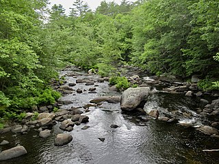
The Umpqua River on the Pacific coast of Oregon in the United States is approximately 111 miles (179 km) long. One of the principal rivers of the Oregon Coast and known for bass and shad, the river drains an expansive network of valleys in the mountains west of the Cascade Range and south of the Willamette Valley, from which it is separated by the Calapooya Mountains. From its source northeast of Roseburg, the Umpqua flows northwest through the Oregon Coast Range and empties into the Pacific at Winchester Bay. The river and its tributaries flow almost entirely within Douglas County, which encompasses most of the watershed of the river from the Cascades to the coast. The "Hundred Valleys of the Umpqua" form the heart of the timber industry of southern Oregon, generally centered on Roseburg.

The Feather River is the principal tributary of the Sacramento River, in the Sacramento Valley of Northern California. The river's main stem is about 73 miles (117 km) long. Its length to its most distant headwater tributary is just over 210 miles (340 km). The main stem Feather River begins in Lake Oroville, where its four long tributary forks join—the South Fork, Middle Fork, North Fork, and West Branch Feather Rivers. These and other tributaries drain part of the northern Sierra Nevada, and the extreme southern Cascades, as well as a small portion of the Sacramento Valley. The total drainage basin is about 6,200 square miles (16,000 km2), with approximately 3,604 square miles (9,330 km2) above Lake Oroville.

Valle San Giovanni is a small village in the province of Teramo, in the Abruzzo region of central Italy. It is a frazione of the town of Teramo.

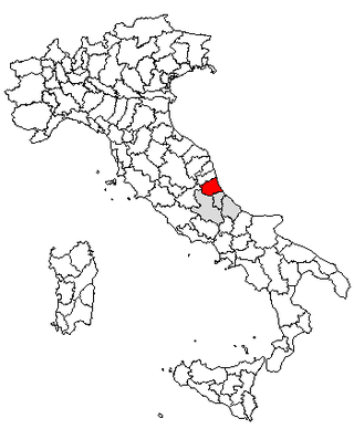
The province of Teramo is a province in the Abruzzo region of Italy. Its capital is the city of Teramo. The province has an area of 1,948 square kilometres (752 sq mi), a population of 313,029 (2012), and is subdivided into 47 comuni, see comunes of the province of Teramo. The province of Teramo shares its northern border with the province of Ascoli Piceno in the Marche region, southern and southwestern borders with the province of L'Aquila in the Abruzzo region, and a western border with the province of Rieti in the Lazio region. To the south is the province of Pescara in the Abruzzo region and to the east is the Adriatic Sea.

Teramo is a city and comune in the Italian region of Abruzzo, the capital of the province of Teramo.

The Drin is a river in Southeastern Europe with two major tributaries – the White Drin and the Black Drin and two distributaries – one discharging into the Adriatic Sea, in the Gulf of Drin and the other into the Bojana River. Its catchment area extends across Albania, Kosovo, Serbia, Greece, Montenegro and North Macedonia and is home to more than 1.6 million people. The river and its tributaries form the Gulf of Drin, an ocean basin that encompasses the northern Albanian Adriatic Sea Coast.

The Metauro is a river in the Marche region of central Italy. It rises in the Apennine Mountains and runs east for 110 kilometres (68 mi) or 121 kilometres (75 mi) if the Meta is included as its uppermost reach.

The Aterno-Pescara is a river system in Abruzzo, eastern central Italy. The river is known as the Aterno near its source in the mountains, but takes the name Pescara, actually a tributary, nearer the city of Pescara and the Adriatic Sea.

The Tagliamento is a braided river in north-east Italy, flowing from the Alps to the Adriatic Sea at a point between Trieste and Venice.

Torricella Sicura is a town and comune in the province of Teramo, in the Abruzzo region of central Italy. It is located in the natural park known as the "Gran Sasso e Monti della Laga National Park".
The Blackwater River is a 37.5-mile-long (60.4 km) river located in central New Hampshire in the United States. It is a tributary of the Contoocook River, part of the Merrimack River watershed.
Ramganga is a tributary of the river Ganges, originating in Uttarakhand state, India.

The Naches River is a tributary of the Yakima River in central Washington in the United States. Beginning as the Little Naches River, it is about 75 miles (121 km) long. After the confluence of the Little Naches and Bumping River the name becomes simply the Naches River. The Naches and its tributaries drain a portion of the eastern side of the Cascade Range, east of Mount Rainier and northeast of Mount Adams. In terms of discharge, the Naches River is the largest tributary of the Yakima River.

The Tronto is a 115-kilometre (71 mi) long Italian river that arises at Monti della Laga and ends in the Adriatic Sea at Porto d'Ascoli, San Benedetto del Tronto. It traverses the Lazio, Marche, and Abruzzo regions of Italy.
Magliano is a village in the Italian region of Abruzzo. It is a frazione of the comune of Torricella Sicura, in the Province of Teramo.
Ioanella is a frazione of the Commune of Torricella Sicura in the Province of Teramo, Italy.

Big Butte Creek is a 12-mile-long (19 km) tributary of the Rogue River in the U.S. state of Oregon. It drains approximately 245 square miles (635 km2) of Jackson County. Its two forks, the North Fork and the South Fork, both begin high in the Cascade Range near Mount McLoughlin. Flowing predominantly west, they meet near the city of Butte Falls. The main stem flows generally northwest until it empties into the Rogue Falls was incorporated in 1911, and remains the only incorporated town within the watershed's boundaries.

The Colorado River is a major river of the western United States and northwest Mexico in North America. Its headwaters are in the Rocky Mountains where La Poudre Pass Lake is its source. Located in north central Colorado it flows southwest through the Colorado Plateau country of western Colorado, southeastern Utah and northwestern Arizona where it flows through the Grand Canyon. It turns south near Las Vegas, Nevada, forming the Arizona–Nevada border in Lake Mead and the Arizona–California border a few miles below Davis Dam between Laughlin, Nevada and Needles, California before entering Mexico in the Colorado Desert. Most of its waters are diverted into the Imperial Valley of Southern California. In Mexico its course forms the boundary between Sonora and Baja California before entering the Gulf of California. This article describes most of the major features along the river.
The Livenza is a river in the Italian provinces of Pordenone, Treviso and Venice. Its source is near Polcenigo and Caneva in Pordenone. It flows in a southeasterly direction past Sacile and forms the border between the provinces of Pordenone and Treviso roughly between Brugnera and Motta di Livenza. It continues to flow in a southeasterly direction, forming the border between the provinces of Treviso and Venice before flowing into the province of Venice near Santo Stino di Livenza. It flows near La Salute di Livenza and finally enters the Adriatic Sea near Caorle.
The Salinello is a river in Italy. It is located in the province of Teramo in the Abruzzo region of southern Italy. The source of the river is in the Monti della Laga range southwest of Montagna dei Fiori. The river flows eastward and curves northeast near Civitella del Tronto. The river then curves southeast near Sant'Egidio alla Vibrata and the border with the province of Ascoli Piceno. Finally, the river flows east near Sant'Omero and enters the Adriatic Sea near Giulianova and Tortoreto Lido.
