Torosay

Last updated
Torosay
Church of Scotland Church, Craignure, Isle of Mull. - geograph.org.uk - 1528644.jpg
Torosay parish church
Argyll and Bute UK location map.svg
Red pog.svg
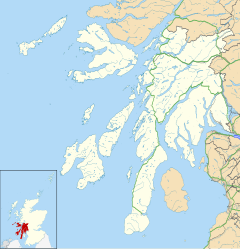
Torosay
Location within Argyll and Bute
Area140 sq mi (360 km2)
Population645 (2011)
  Density 5/sq mi (1.9/km2)
OS grid reference NM717371
Civil parish
  • Torosay
Council area
Lieutenancy area
Country Scotland
Sovereign state United Kingdom
Post town ISLE OF MULL
Postcode district PA65
Dialling code 01680
Police Scotland
Fire Scottish
Ambulance Scottish
UK Parliament
Scottish Parliament
List of places
UK
Scotland
56°28′2″N5°42′2″W / 56.46722°N 5.70056°W / 56.46722; -5.70056
Parishes of the Isle of Mull (1891) Torosay shown in red (labelled 10) Map of the parishes of the Isle of Mull (1891).jpg
Parishes of the Isle of Mull (1891)Torosay shown in red (labelled 10)

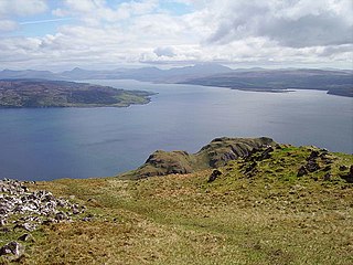
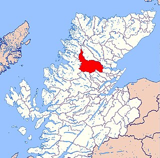
Torosay is a civil parish on the Isle of Mull in the county of Argyll, Scotland, part of the Argyll and Bute council area. It is one of three parishes on the island and extends over the central and south-eastern part. It is bordered by the parish of Kilninian and Kilmore in the north and Kilfinichen and Kilvickeon in the south-west. It extends about 12 miles (19 kilometres) east-west and 10 miles (16 kilometres) north-south. On the north-east coast it is separated from the mainland by the Sound of Mull. On its south-east coast, part of it is almost severed from the rest of the parish by the sea lochs Spelve and Buie, together with the freshwater loch Uisg, in between. This peninsula, which includes the hamlet of Croggan, is joined to the main island by a small isthmus at Kinlochspelvie and another at the settlement of Lochbuie. There is a smaller sea loch Loch Don, which gives its name to the hamlet of Lochdon (or Lochdonhead). [1] Further north, there is a bay at Craignure which is the location of a ferry port.

Contents

The parish touches the west coast of Mull at Loch na Keal and includes the island of Eorsa. The River Ba, which flows into this loch, takes the overflow of the freshwater loch Loch Ba 2 miles (3.2 kilometres) inland. Also in the west of the parish, by its south-west border, is Ben More (3,169 ft (966 m)), the highest point in the island (the name means great mountain in Gaelic). [1]


At the 2011 census, the population of the civil parish was 645. 17.5% had some knowledge of Gaelic. [2] In 1891 80% were Gaelic speaking. [3] The area of the parish is 89,584 acres (140.0 sq mi; 362.5 km2). [4]


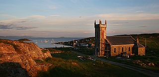
The parish church of Torosay, which is in Craignure, dates from 1783. Its style is plain Georgian oblong. It underwent repairs in 1828 and again in 1832, when it was struck by lightning. [5] [6] In the 19th century, churches were built by the government at Kinlochspelvie and Salen, resulting in separate quoad sacra (church only) parishes; but the former is now reunited with Torosay, while the latter still exists . [7] [1]


The name Torosay appears to be derived from the Gaelic word for a conical hill and influenced by the common Old Norse ending ay , meaning island. [6] [8]

The parish council was formed in 1895 with 7 elected members. [9] This was replaced by Mull District Council in 1930, which had 6 members, 3 of whom were the County Councillors for Mull and 3 elected to the District Council from wards based on the three parishes. [10] [11] Since 1976 there has been an Isle of Mull community council. [12] [13] [14]


Landmarks


Settlements

Related Research Articles

<span class="mw-page-title-main">Argyll and Bute</span> Council area of Scotland

Argyll and Bute is one of 32 unitary council areas in Scotland and a lieutenancy area. The current lord-lieutenant for Argyll and Bute is Jane Margaret MacLeod. The administrative centre for the council area is in Lochgilphead at Kilmory Castle, a 19th-century Gothic Revival building and estate. The current council leader is Robin Currie, a councillor for Kintyre and the Islands.

<span class="mw-page-title-main">Isle of Mull</span> Island off the coast of Scotland

The Isle of Mull or just Mull is the second-largest island of the Inner Hebrides and lies off the west coast of Scotland in the council area of Argyll and Bute.

<span class="mw-page-title-main">Argyll</span> Historic county in Scotland

Argyll, sometimes called Argyllshire, is a historic county and registration county of western Scotland.

<span class="mw-page-title-main">Coll</span> Island and parish in the Inner Hebrides, Scotland

Coll is an island located west of the Isle of Mull in the Inner Hebrides of Scotland. Coll is known for its sandy beaches, which rise to form large sand dunes, for its corncrakes, and for Breacachadh Castle. It is in the council area of Argyll and Bute.

<span class="mw-page-title-main">Duart Castle</span> Castle in Scotland

Duart Castle, or Caisteal Dhubhairt in Scottish Gaelic, is a castle on the Isle of Mull, beside the Sound of Mull off the west coast of Scotland, within the council area of Argyll and Bute. The castle dates back to the 13th century and is the seat of Clan MacLean. One source states that the castle was "brought back from ruin in 1911". The regimental colours of the WW1 Canadian Expeditionary Force 236th Battalion, CEF are laid up in the Great Hall.

<span class="mw-page-title-main">Clan Maclean</span> Highland Scottish clan

Clan Maclean is a Highlands Scottish clan. They are one of the oldest clans in the Highlands and owned large tracts of land in Argyll as well as the Inner Hebrides. Many early MacLeans became famous for their honour, strength and courage in battle. They were involved in clan skirmishes with the Mackinnons, Camerons, MacDonalds and Campbells, as well as all of the Jacobite risings.

<span class="mw-page-title-main">Craignure</span> Ferry port on Isle of Mull, Scotland

Craignure is a village and the main ferry port on the Isle of Mull, Argyll and Bute, Scotland. The village is within the parish of Torosay.

<span class="mw-page-title-main">Salen, Mull</span> Human settlement in Scotland

Salen is a settlement on the Isle of Mull, Scotland. It is on the east coast of the island, on the Sound of Mull, approximately halfway between Craignure and Tobermory at the narrowest part of the island. The full name of the settlement is 'Sàilean Dubh Chaluim Chille'. In 1991 it had a population of 500.

<span class="mw-page-title-main">Sound of Mull</span> Sound between the Inner Hebridean island of Mull and mainland Scotland

The Sound of Mull is a sound between the Inner Hebridean island of Mull and mainland Scotland. It forms part of the Atlantic Ocean.

<span class="mw-page-title-main">Resolis</span> Human settlement in Scotland

Resolis is a village and parish on the B9163 road, in the Black Isle in Scotland. It is part of the Presbytery of Ross. In 2011 it had a population of 362.

<span class="mw-page-title-main">Croggan</span> Human settlement in Scotland

Croggan is a small scattered settlement on the Loch Spelve sea loch, in the south of the Isle of Mull, Argyll and Bute, Scotland. It is located in the Torosay parish. The nearest village is Lochbuie.

Moonzie is a small parish in Fife, Scotland, about 3 miles north-west of Cupar. It is bounded on the west by Creich, on the north by Kilmany, on the south-east by Cupar and on the south-west by Monimail.

<span class="mw-page-title-main">Abdie</span> Human settlement in Scotland

Abdie is a parish in north-west Fife, Scotland, lying on the south shore of the Firth of Tay on the eastern outskirts of Newburgh, extending about 3 miles eastwards to the boundary of Dunbog parish, with which it is now united ecclesiastically and for the Community Council. It is also bounded by Collessie on the south and has a small border with the parish of Moonzie in the south-east.

Kincardine is a civil parish in the Scottish council area of Stirling and the former county of Perthshire in the historic district of Menteith.

<span class="mw-page-title-main">Lochdon</span> Human settlement in Scotland

Lochdon or Lochdonhead is a small village on the Isle of Mull, in the council area of Argyll and Bute, off the west coast of Scotland. The village is within the parish of Torosay, just south of Craignure on the A849 at the head of Loch Don. The name Lochdonhead means "The head of the bad loch".

<span class="mw-page-title-main">Kincardine (Ardgay and District)</span> Human settlement in Scotland

Kincardine is an extensive civil parish and Community council area on the south side of the Kyle of Sutherland, within the Highland unitary authority area of Scotland, the largest settlement being Ardgay.

Kildonan is a parish in Sutherland, Scotland. It is located in the east next to the boundary with Caithness. It has a coast line of about 5 miles, but extends about 25 miles inland. Its main settlement is Helmsdale.

<span class="mw-page-title-main">Lochbroom, Highland</span> Human settlement in Scotland

Lochbroom is a civil parish in Ross and Cromarty, Scotland, part of the Highland Unitary Authority area. Its name is Gaelic (Lochbraon), meaning "loch of rain showers". It completely surrounds Loch Broom, a sea loch extending from 7 miles (11 km) inland from the Minch on the west coast of Scotland. The former parish church stands at the head of this loch, hence the name of the parish. Lochbroom is also a Community council area, but the north-west corner of the parish is the Coigach community council area.

<span class="mw-page-title-main">Kilfinichen and Kilvickeon</span> Civil parish on Isle of Mull, Scotland

Kilfinichen and Kilvickeon is a civil parish on the Isle of Mull in the county of Argyll, Scotland, part of the Argyll and Bute council area. It is one of three parishes on the island and extends over the south-western part and includes the islands of Iona, Erraid and Inch Kenneth. It is bordered by the parish of Torosay in the north and east. It extends about 23 miles north-east to south-west and is 18 miles wide.

<span class="mw-page-title-main">Kilninian and Kilmore</span> Civil parish on Isle of Mull, Scotland

Kilninian and Kilmore is a civil parish on the Isle of Mull in the county of Argyll, Scotland, part of the Argyll and Bute council area. It is one of three parishes on the island and extends over the north-western part. It is bordered by the parish of Torosay in the south-east. It extends about 15 miles north-west to south-east and is 13 miles wide.

References

  1. 1 2 3 Ordnance Gazetteer of Scotland, by Francis H. Groome; publ. Thomas C. Jack, Edinburgh,1901. (Article on Torosay)
  2. Census of Scotland 2011, Table KS101SC Usually Resident Population, publ. by National Records of Scotland. Web site http://www.scotlandscensus.gov.uk/ retrieved April 2021. See "Standard Outputs", Table KS101SC, Area type: Civil Parish
  3. Tenth Decennial Census of the Population of Scotland, Taken 5th April 1891, publ. H.M.S.O. Edinburgh 1893; Table 1, p.12
  4. Census of Scotland 1931. Preliminary Report. Table 17 - Population and Acreage of Civil Parishes alphabetically arranged. Publ. H.M.S.O. 1931
  5. Historic Environment Scotland website portal.historicenvironment.scot/designation/LB17970 retrieved March 2024
  6. 1 2 New Statistical Acccount Vol 7 (Article on Torosay), publ. William Blackwood & Sons, Edinburgh, 1845; pp.277-292
  7. Website of North Mull Parishes (Church of Scotland) www.northmullparish.org retrieved March 2024. Note: The parishes have a common minister.
  8. Place-names of Scotland, by James Johnston, publ. David Douglas, Edinburgh, 1892; p.237
  9. The Parish Council Nominations in the Glasgow Herald, 21 March 1895; p.8
  10. Local Government (Scotland) Act, 1929
  11. The Edinburgh Gazette 7 March 1930; p.265
  12. Community Councils website, managed on behalf of the Scottish Government www.communitycouncils.scot/community-council-finder Retrieved April 2021
  13. Local Government (Scotland) Act 1973
  14. Website of Isle of Mull community council - mull-community-council.co.uk/ - retrieved March 2024