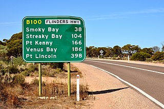
Flinders Highway connects the South Australian towns of Ceduna and Port Lincoln, a distance of 396 kilometres (246 mi) Flinders Highway – along with Lincoln Highway – presents an alternative but somewhat longer coastal route between Ceduna and Port Augusta, compared to the more direct route along Eyre Highway. It is designated route B100.
South Road and its southern section as Main South Road outside of Adelaide is a major north–south conduit connecting Adelaide and the Fleurieu Peninsula, in South Australia. It is one of Adelaide's most important arterial and bypass roads. As South Road, it is designated part of route A2 within suburban Adelaide. As Main South Road, it is designated part of routes A13 and B23.
Portrush Road is a major arterial route through the eastern suburbs of Adelaide, the capital of South Australia. This name covers many consecutive streets and is not widely known to most drivers except for the southernmost section, as the entire allocation is still best known as by the names of its constituent parts: Hampstead Road, Taunton Road, Ascot Avenue, Lower Portrush Road, and Portrush Road proper. This article will deal with the entire length of the corridor for sake of completion, as well to avoid confusion between declarations. Portrush Road is designated route A17.

Cross Road is a major arterial road that travels east–west through the inner southern suburbs of the Australian city of Adelaide. It is designated route A3.
Grand Junction Road is the longest east–west thoroughfare in the Adelaide metropolitan area, traversing through Adelaide's northern suburbs approximately 8 kilometres north of the Adelaide city centre.
Port Road is a major road in Adelaide, South Australia connecting the Adelaide city centre with Port Adelaide. It is 12 km (7.5 mi) long, and is designated part of route R1 within central Adelaide, and beyond as route A7.
Adelaide–Mannum Road is a road that runs through the northern Adelaide Hills between the South Australian capital, Adelaide and Mannum on the Murray River. It is designated route A10 in the metropolitan area and B10 in rural areas, and is 79 kilometres in length. This name covers many consecutive streets and is not widely known to most drivers, as the entire allocation is still best known as by the names of its constituent parts: Northcote Terrace, North East Road, Torrens Valley Road, Randell Road and Adelaide Road. This article will deal with the entire length of the corridor for sake of completion, as well to avoid confusion between declarations.
Salisbury Highway is a 15 kilometre major connecting road in the northern suburbs of the Adelaide metropolitan area. It is designated part of route A9.

Sir Donald Bradman Drive is a major arterial road that travels east–west through the western suburbs of Adelaide, South Australia. It is the main route from the Adelaide city centre to the Adelaide Airport.
Victor Harbor Road is a major road in South Australia that runs south from Main South Road at Old Noarlunga on the southern fringes of suburban Adelaide to Victor Harbor on the Fleurieu Peninsula. It is designated part of route A13.
Victoria Road is a major road in Adelaide, South Australia, connecting Port Adelaide to Outer Harbor on the LeFevre Peninsula. It is designated part of route A16.
Lower North East Road is an arterial road in the northeastern suburbs of Adelaide, South Australia. It links the north-eastern corner of Adelaide to Houghton in the Adelaide Hills, and is an urban alternative to North East Road.
Adelaide has two city ring routes, that loop around the Adelaide city centre and North Adelaide, known as the Inner and Outer Ring Routes.
Strathalbyn Road is a South Australian road connecting the towns of Aldgate, Mylor, Echunga, Macclesfield and Strathalbyn, designated part of route B33.
Marion Road is a north–south arterial road through the western suburbs of Adelaide, South Australia, named after its traversal through the suburb of Marion and the local government area of City of Marion. It is designated part of route A14.
Regency Road is a main east-west road forming a continuous connection between the inner northern suburbs of Adelaide, South Australia. Located approximately 6 kilometres (3.7 mi) north of the city centre, Regency Road carries a large amount of freight traffic, being located near Regency Park and the Churchill Road industrial area.
Churchill Road is an arterial road in the inner northern suburbs of Adelaide, Australia.
Prospect Road is a north–south road in the inner north suburbs of Adelaide, Australia.
McIntyre Road is an arterial road crossing through northern and northeastern suburbs of Adelaide in South Australia. It is designated route A18.
Grange Road is an arterial road in the western suburbs of Adelaide, South Australia. It runs from the coast at Grange to South Road, close to the city centre.

