

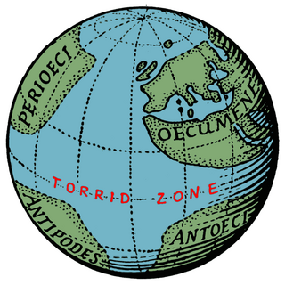
The torrid zone was the name given by ancient Greek and Roman geographers to the equatorial area of the Earth, so hot that it was impenetrable. That notion became a deterrent for European explorers until the 15th century.
The torrid zone was the name given by ancient Greek and Roman geographers to the equatorial area of the Earth, so hot that it was impenetrable. That notion became a deterrent for European explorers until the 15th century.
Aristotle posited that the western half of the temperate zone on the other side of the world from Greece might be habitable and that, because of symmetry, there must be in the Southern Hemisphere a temperate zone corresponding to that in the northern. He thought, however, that the excessive heat in the torrid zone would prevent the exploration. [1]
Strabo referred to:
the meridian through Syene is drawn approximately along the course of the Nile from Meroë to Alexandria, and this distance is about ten thousand stadia; and Syene must lie in the centre of that distance; so that the distance from Syene to Meroë is five thousand stadia. And when you have proceeded about three thousand stadia in a straight line south of Meroë, the country is no longer inhabitable on account of the heat, and therefore the parallel though these regions, being the same as that through the Cinnamon-producing Country, must be put down as the limit and the beginning of our inhabited world on the South. [2]
In 8 AD the poet Ovid wrote in his Metamorphoses .
...the celestial vault is cut by two zones on the right and two on the left, and there is a fifth zone between, hotter than these, so did the providence of God mark off the enclosed mass with the same number of zones, and the same tracts were stamped upon the earth. The central zone of these may not be dwelt in by reason of the heat [3]
Pomponius Mela, the first Roman geographer, asserted that the Earth had two habitable zones, a north and a south one. The second population were known as Antichthones. However, it would be impossible to get into contact with each other because of the unbearable heat at the equator (De orbis situ 1.4).
Many Europeans had assumed that Cape Bojador, in Western Sahara, marked the beginning of the impenetrable torrid zone until 1434, when the Portuguese sailed past the cape and reported that no torrid zone existed. [4]
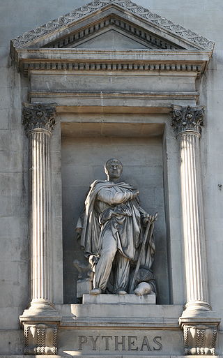
Pytheas of Massalia was a Greek geographer, explorer and astronomer from the Greek colony of Massalia. He made a voyage of exploration to northwestern Europe in about 325 BC, but his account of it, known widely in antiquity, has not survived and is now known only through the writings of others.

Eratosthenes of Cyrene was a Greek polymath: a mathematician, geographer, poet, astronomer, and music theorist. He was a man of learning, becoming the chief librarian at the Library of Alexandria. His work is comparable to what is now known as the study of geography, and he introduced some of the terminology still used today.

Strabo was a Greek geographer, philosopher, and historian who lived in Asia Minor during the transitional period of the Roman Republic into the Roman Empire.

The tropics are the regions of Earth surrounding the Equator. They are defined in latitude by the Tropic of Cancer in the Northern Hemisphere at 23°26′10.1″ (or 23.43614°) N and the Tropic of Capricorn in the Southern Hemisphere at 23°26′10.1″ (or 23.43614°) S. The tropics are also referred to as the tropical zone and the torrid zone.

Cecrops was a mythical king of Attica which derived from him its name Cecropia, having previously borne the name of Acte or Actice. He was the founder and the first king of Athens itself though preceded in the region by the earth-born king Actaeus of Attica. Cecrops was a culture hero, teaching the Athenians marriage, reading and writing, and ceremonial burial.

In Greek mythology, Lichas was Heracles' servant, who brought the poisoned shirt from Deianira to Hercules because of Deianira's jealousy of Iole, which killed him.

The history of geodesy (/dʒiːˈɒdɪsi/) began during antiquity and ultimately blossomed during the Age of Enlightenment.
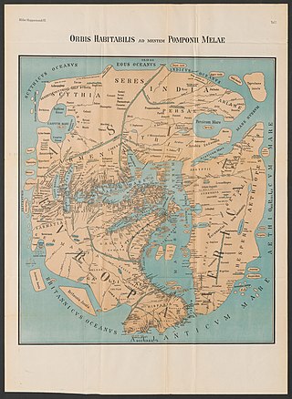
Pomponius Mela, who wrote around AD 43, was the earliest known Roman geographer. He was born in Tingentera and died c. AD 45.
Crates of Mallus was a Greek grammarian and Stoic philosopher, leader of the literary school and head of the library of Pergamum. He was described as the Crates from Mallus to distinguish him from other philosophers by the same name. His chief work was a critical and exegetical commentary on Homer. He is also famous for constructing the earliest known globe of the Earth.

The climes in classical Greco-Roman geography and astronomy were the divisions of the inhabited portion of the spherical Earth by geographic latitude.

The Cataracts of the Nile are shallow lengths of the Nile river, between Khartoum and Aswan, where the surface of the water is broken by many small boulders and stones jutting out of the river bed, as well as many rocky islets. In some places, these stretches are punctuated by whitewater, while at others the water flow is smoother but still shallow.
Deimachus or Daimachus was a Greek from Plataeae, who lived during the third-century BCE. He became an ambassador to the court of the Mauryan ruler Bindusara "Amitragatha" in Pataliputra in India. Deimachus was sent by Antiochus I Soter.
Amanirenas, was queen regnant of the Kingdom of Kush from the end of the 1st century BCE to beginning of the 1st century CE. She is known for halting the Roman expansion into Kush in present-day Sudan.
The five main latitude regions of Earth's surface comprise geographical zones, divided by the major circles of latitude. The differences between them relate to climate. They are as follows:

The Macrobians (Μακροβίοι) were a legendary people and kingdom positioned in the Horn of Africa mentioned by Herodotus. Later authors place them in India instead. It is one of the legendary peoples postulated at the extremity of the known world, in this case in the extreme south, contrasting with the Hyperboreans in the extreme north.

Regio Patalis is Latin for “the region of Patala”, that is the region around the ancient city of Patala at the mouth of the Indus River in Sindh, Pakistan. The historians of Alexander the Great state that the Indus parted into two branches at the city of Patala before reaching the sea, and the island thus formed was called Patalene, the district of Patala. Alexander constructed a harbour at Patala.
Rhoiteion was an ancient Greek city in the northern Troad region of Anatolia, also known as Ῥοίτιον ἄκρον. Its territory was bounded to the south and west by the Simoeis river and to the east by Ophryneion. It was located on the Baba Kale spur of Çakal Tepe north of Halileli and west of İntepe in Çanakkale Province, Turkey.

Earth's circumference is the distance around Earth. Measured around the equator, it is 40,075.017 km (24,901.461 mi). Measured passing through the poles, the circumference is 40,007.863 km (24,859.734 mi).
Bybassus or Bybassos or Bubassus or Bubassos was a town in ancient Caria. Ephorus, according to Stephanus of Byzantium, wrote Bybasstum or Bybasston (Βύβασστον) and Bybastium or Bybastion (Βυβάστιον); and Diodorus means the same place, when he calls it Bubastus of the Chersonesus. Pliny the Elder has a "regio Bubassus;" and he adds, "there was a town Acanthus, otherwise called Dulopolis." He places the "regio Bubassus" next to Triopia, the district of Triopium. Finally, Pomponius Mela mentions a Bubassius Sinus. The Bubassia Chersonesus is mentioned by Herodotus. Herodotus tells a story of the Cnidians attempting to cut a canal through a narrow neck of land for the purpose of insulating their peninsula, and protecting themselves against the Persians; they were at the work while Harpagus was conquering Ionia. The isthmus where they made the attempt was five stadia wide, and rocky. This place cannot be the isthmus which connects the mainland with the high peninsula, once called Cape Krio (now Cape Deveboynu, for it is sandy, and Strabo says that Cape Krio was once an island, but in his time was connected with the land by a causeway. Besides this, the chief part of the city of Cnidus was on the mainland; though we cannot be sure that this was so in the time of Harpagus. The passage in Herodotus is somewhat obscure, but mainly because it is ill pointed. His description is in his usually diffuse, hardly grammatical, form. Herodotus says, "Both other Hellenes inhabit this country and Lacedaemonian colonists, Cnidians, their territory being turned to the sea, and commencing from the Chersonesus Bubassiae, and all the Cnidia being surrounded by the sea, except a small part (for on the north it is bounded by the Gulf Ceramicus, and on the south by the sea in the direction of Syme and Rhodus; now at this small part, being about five stadia, the Cnidians were working to dig a canal." It is clear, then, that he means a narrow neck some distance east of the town of Cnidus.
Cerasus or Kerasous was a town of ancient Pontus, on the Black Sea coast, a little to the west of Trapezus. The Ten Thousand, in their retreat, came to Trapezus, and leaving Trapezus, "they arrive on the third day at Cerasus, an Hellenic city on the sea, a colony of the Sinopeis, in Colchis." The Anonymous geographer of Ravenna places Cerasus 60 stadia east of Coralla, and 90 west of Hieron Oros, and on a river of the same name. The name, and possibly the population, of the town were translated to Pharnacia in the Hellenistic era.
{{cite book}}: CS1 maint: location (link)