Last updated Glyph of Cempoala, the capital city of Totonacapan
Totonacapan[pronunciation?] refers to the historical extension where the Totonac people of Mexico dominated, as well as to a region in the modern states of Veracruz and Puebla. The historical territory was much larger than the currently named region, extending from the Cazones River in the north to the Papaloapan River in the south and then west from the Gulf of Mexico into what is now the Sierra Norte de Puebla region and into parts of Hidalgo. When the Spanish arrived, the Totonac ethnicity dominated this large region, although they themselves were dominated by the Aztec Empire. For this reason, they allied with Hernán Cortés against Tenochtitlán. However, over the colonial period, the Totonac population and territory shrank, especially after 1750 when mestizos began infiltrating Totonacapan, taking political and economic power. This continued into the 19th and 20th centuries, prompting the division of most of historical Totonacpan between the states of Puebla and Veracruz. Today, the term refers only to a region in the north of Veracruz where Totonac culture is still important. This region is home to the El Tajín and Cempoala archeological sites as well as Papantla, which is noted for its performance of the Danza de los Voladores.
The earliest human settlements in the area date back to about 2000 BCE with agriculture practiced early with those communities on the coast having seafood prominent in the diet, especially mollusks. The area thrived with many small villages and ceremonial center because of abundant agricultural production. The beginning of the Classic period around 300BCE brought great changes to the region as it became part of an important trade route between Teotihuacan and the Maya. Evidence of Teotihuacan influence become evident including religion and architecture.[1]
The name "Totonacapan" is from the Totonac people (+ "pan" meaning "place"), who probably arrived to the area between the 8th and 9th centuries. It was populated by other cultures before this, which have since been lost.[1] It is not known how the Totonacs came to occupy and dominate the region, and there are several theories, some of which point to links with Teotihuacan and/or a migration from the interior towards the Gulf coast.[2] Their main archeological sites include El Tajín, Cempoala and Yohualichan (in the Sierra Norte de Puebla). El Tajín is considered crucial to Totonac identity.[3] The territory originally extended from the Papaloapan River in the south to the Cazones River in the north, the Gulf of Mexico on the east and into the Sierra Madre Oriental mountains to the west into what is now the Sierra Norte de Puebla and perhaps even as far as Tulancingo. However, these western areas had become ethnically mixed due to influxes of Nahuas and Otomis long before the Spanish arrived. They were also heavily influenced by the olmec.[1][2]
19th century Carl Nebel lithograph of people from Totonacapan
When the Spanish arrived in the 16th century, the region was dominated by the Totonacs, who were then in turn dominated by the Aztec Empire. Because of this, the Totonacs allied with the Spanish against the Aztecs to conquer Tenochtitlán .[4][3] However, war, disease and forced labor brought the Totonac population down drastically. The Totonac population in Cempoala is estimated to have been about 80,000 when the Spanish arrived in 1519 but with only eighty left in 1550.[2] The Spanish also took their lands for cattle raising until the ethnicity occupied only about half of what it used to. In many areas, the Totonac population was replaced by Spanish, mestizo and African peoples. Until the 17th century, the Spanish mostly respected Totonac leadership as their help against the Aztec made them non-threatening militarily. Evangelization was likewise slow, with only sixteen parishes in all of Totonacapan by 1750.[3]
This means that until 1750, the political and social situation in Totonacapan was relatively stable. However, from this time to the present various political, social and economic developments have served to weaken and split Totonac control over its historical territory. Mestizos began to take indigenous land and felt sufficiently powerful enough to begin taking political and military power. From 1750 to 1820, there were a series of Totonac revolts against these incursions, especially in the Papantla and Orizaba regions. This rebellion caused the Totonacs to ally with the cause for independence early, led by Serafín Olarte, but they were crushed by royalist forces.[3]
The struggle continued after Independence with a new insurrection led by Olarte's son, Mariano Olarte with the flash point being the prohibition of Totonac Holy Week rites, which the Puebla diocese deemed “too pagan.” The first president of Mexico, Guadalupe Victoria, who had fought with Serafín Olarte, mediated the dispute but was unable to get the diocese to relent.[3] The rebellions by the Totonac spurred mestizo and Spanish authorities into a series of moves that resulted in the splitting of historical Totonacapan mostly between the modern states of Veracruz and Puebla, with some small areas now part of Hidalgo over the course of the 19th century. Borders fluctuated over this time but were set by the beginning of Mexican Revolution.[3][5]
The mestizos, meanwhile, were privatizing communally held land, confiscating religious property and prohibiting public worship to weaken the power of indigenous authorities. The Totonacs had some luck in turning the tide during the Mexican Revolution but these gains were lost in the 1930s. The process of dividing Totonacapan into various smaller entities politically and economically continued through the 20th century. One development was the construction of the Mexico City-Tuxpan highway and the development of petroleum extraction in the Poza Rica area. The Teziutlán-Tlatlauquitepec highway to Tenampulco reinforced a Veracruz/Puebla border.[3]
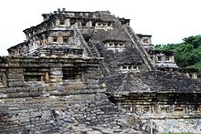
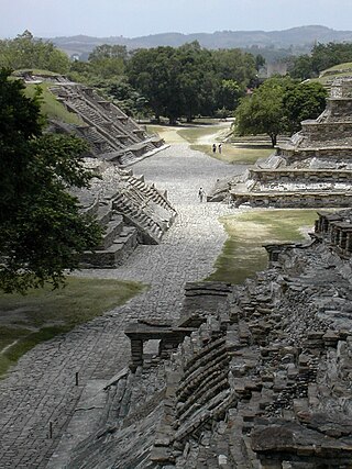
The most important archeological site in the region is El Tajín, located near Papantla, and is one of the largest and most important cities of the Classic era of Mesoamerica. A part of the Classic Veracruz culture, El Tajín flourished from 600 to 1200 C.E. and during this time numerous temples, palaces, ballcourts, and pyramids were built.[7]
El Tajín was named a World Heritage Site in 1992, due to its cultural importance, especially to the Totonac people and its architecture.[8] This architecture includes the use of decorative niches and cement in forms unknown in the rest of Mesoamerica.[9] Its best-known monument is the Pyramid of the Niches, but other important monuments include the Arroyo Group, the North and South Ballcourts and the palaces of Tajín Chico.[10] Since the 1970s, El Tajin has been the most important archeological site in Veracruz for tourists, attracting over 650,000 visitors a year.[11]
The next most important site is Cempoala which during the height of the Totonacs, was the most important city. It was still important when the Spanish arrived, but it became mostly abandoned afterwards.[4]
The area contains some of the earliest known archeological sites in Veracruz such as Trapiche, Chalahuite el Viejón, Limoncito and Tlalixcoyan. One of the earliest sites dates to around 1500 BCE is Remojadas which is considered the center of a pre Totonac culture called by the same name.[1]
Most of the modern Totonacapan of Veracruz state extends from the coast to the edges of the Sierra Madre Oriental, with altitudes of between zero and 800 meters above sea level.[4] Most of it has a hot and humid climate with extreme lows reaching 5C in the highest elevations and high temperatures reaching 38C between March and June. The average annual temperature ranges from 15 to 20C. Annual rainfall averages between 1,500 and 1,800mm per year with most falling between July and November.[4]
The most important rivers include Cazones, Tecolutla and Necaxa, which is a tributary of the Tecolutla. There are also numerous streams the largest of which include the Zozocolco, the Tecacán and the Chumatlán. The wild vegetation is tropical rainforest, rich in hardwoods with include species such as cedar,[specify] mahogany (Swietenia humilis and S. macrophylla), kapok fibre trees (Ceiba pentandra), Mexican laurel, Salix (willow) and fig species.[4][12] However, their range is limited to less than 4,000 hectares (9,900 acres) in about seven municipalities. Wildlife includes squirrels, rabbits, armadillos, opossums, fresh and saltwater shrimp, trout, and various bird species.[4]
Economy
Fields in Cazones de Herrera
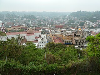
Totonacapan is one of Mexico poorest regions, despite the fact that there is oil production in and around Poza Rica. The reason is that much of the region is still isolated and rural. For example, Mecatlan is one of the sixty poorest municipalities in the country, with half of home without running water and seventy percent with dirt floors. Illiteracy is four times the national level.[13] Infrastructure such as roadways and housing is in poor condition especially in the mountain areas.[14] The construction of bridges is considered to be important to the regions development, especially to connect the coastline with the interior cities of Mexico.[15]
The principal economic activities are agriculture, the raising of cattle and in some areas, fishing. The coastal areas mostly produce corn with two harvests per year along with beans, chili peppers, oranges, limes, grapefruit, mandarin oranges, sugar cane, bananas, vanilla, sesame seed and more. The mountain areas principally grow coffee, black pepper, sapote and red mamey. Much of the citrus fruit is exported. Aside from cattle there is some other livestock such as pigs, sheep, horses and domestic fowl as well as bees.[12][4]
The mountain areas of the region are home to the vanilla plant, which is a kind of orchid which produces the bean from which the flavoring comes.[16][17] The bean was highly valued long before the arrival of the Spanish, used for religious rituals, perfumes and healing potions as well as a flavoring. When the Aztecs conquered Totonacapan, part of the tribute was in vanilla beans, mostly used to flavor chocolate drinks in Tenochtitlán. In the recent past, vanilla was a major trade in the region, with a number of vanilla “barons” in the first half of the 20th century making fortunes as middlemen and exporters. However, it began to be grown more cheaply elsewhere and the creation of synthetic vanilla collapsed the market for authentic Mexican vanilla. Despite the quality due to ideal growing conditions, Mexico produces only fifteen percent of the world's vanilla. However, a number of entrepreneurs are working to bring the crop back experimenting with production rates and promoting the quality of Totonacapan-grown vanilla.[18] The best vanilla still comes from here.[16]
Panorama of downtown Poza Rica
The Tecolutla, Nautla and Vega de la Torre zones are fishing centers were cooperatives catch catfish, crayfish and other species although crayfish species are endangered.[12]
The main industry is related to oil and gas production although this is limited to the very north of the region.[12] There are also some small industries dedicated to the production of bricks, piloncillo, furniture and handcrafts.[4]
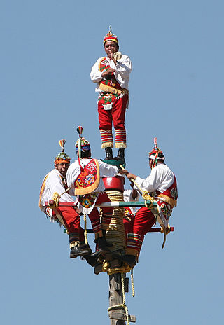
One nascent economic initiative is ecotourism, with nature parks such as Parque Xanath just outside Papantla and the Totonac culture, especially the Voladores and the growing of vanilla. Papantla is the modern capital of Totonac culture, with a Volador pole in the atrium of the main church. Zozocolca has various waterfalls surrounded by large and leafy trees and slabs of rock which guide the water. Parque Takilhsukut is a nature park which is also dedicated to the preservation of Totonac culture with workshops, concerts, and more for both visitors and the local population. Its school for Voladores has children as young as nine. It is one of the sites of the Cumbre Tajín annual festival.[19]
Demographics and culture
Totonac man in church atrium of Papantla
Although the Totonac people are no longer the dominant population in Totonacapan, their culture remains an important part of the Veracruz region still named for them. The various municipalities have formal, generally mestizo-dominated, governments but there are also councils of elders in many indigenous communities which have various relationships with the various municipal authorities.[4]
Totonac languages are principally spoken in Veracruz, the north of Puebla and some areas of Hidalgo. Both of the main branches of the language are spoken in Totonacapan in Veracruz where about half of all Totonac speakers live.[2] The percentage of ethnic Totonacs which speak the language is declining as parents stop teaching it to their children. This phenomenon is more pronounced in the lowland areas where it has all but disappeared in some places. The largest concentration of speakers is in Papantla with large concentrations on the Veracruz/Puebla border.[2]
Traditional dances play an important part in Totonac identity. There are four basic categories: Voladores, those depicting aspects of the Spanish conquest, Afro-European and those which were imposed by Catholic clergy such as those performed during Las Posadas.[3] The best known of these dances is the Ritual Ceremony of the Voladores of Papantla, which has been recognized as an Intangible Cultural Heritage by UNESCO.[20] However, these dances are also waning and survive mostly in marginalized communities. In very poor communities, dances are dying out because the people do not have the time or money to make or maintain the elaborate costumes. As older instructors die, there are no younger ones to take their place.[21]
Most of the population is Catholic although these are split into those who practice the traditional mix of indigenous and Catholic beliefs and reform Catholics who put less emphasis on the political and social aspects of traditional religious practice. In the 1950s, Protestantism was introduced to the area by the Instituto Lingüístico de Verano which now includes evangelists, Baptists and Pentecostals.[3]
Much of the region's cuisine is based on corn, along with wild and cultivated plants and fruits.[22] Much of traditional cuisine survives because of the area's relative remoteness and traditional women still cook over wood fires, grinding corn and other foods on metates. Dishes include soups made from squash, sweet corn and beans. Beans are flavored with sesame seed. Small dishes include tlacoyos with beans, chili peppers with sesame seed, tamales with salted fish, turkey and other fillings, enchiladas zampadas. Vegetable dishes include a green called quelite with beans or with herbs and eggs, chayote with squash seeds, enchiladas with mamey and nopal cactus with eggs. Seafood dishes include shrimp in various preparations including with sesame seed and sweet potato and grilled fish. Meats include various domestic fowl, pork, beef and rabbit, often smoked. Most ingredients are indigenous with a few exceptions such as sesame seed and almonds.[23] Another common dish is zacahuil, which is a kind of corn pudding.[16]
The Cumbre Tajín is considered to be one of Mexico's five largest festivals and one of the 100 most important in the world. Centered on three sites over five days, the aim of the event is to promote Totonacapan's culture, identity and economy. The event had an economic impact of between 180 and 200 million pesos with over 400,000 visitors, temporarily employing 8,000 workers. The event attracts over 5,000 artists from Veracruz, Mexico and the world with about the same number of activities.[24]
Related Research Articles
Veracruz, formally Veracruz de Ignacio de la Llave, officially the Estado Libre y Soberano de Veracruz de Ignacio de la Llave, is one of the 31 states which, along with Mexico City, comprise the 32 Federal Entities of Mexico. Located in eastern Mexico, Veracruz is bordered by seven states, which are Tamaulipas, San Luis Potosí, Hidalgo, Puebla, Oaxaca, Chiapas, and Tabasco. Veracruz is divided into 212 municipalities, and its capital city is Xalapa-Enríquez.
The Totonac are an indigenous people of Mexico who reside in the states of Veracruz, Puebla, and Hidalgo. They are one of the possible builders of the pre-Columbian city of El Tajín, and further maintained quarters in Teotihuacán. Until the mid-19th century they were the world's main producers of vanilla.
Papantla is a city and municipality located in the north of the Mexican state of Veracruz, in the Sierra Papanteca range and on the Gulf of Mexico. The city was founded in the 13th century by the Totonacs and has dominated the Totonacapan region of the state since then. The region is famed for vanilla, which occurs naturally in this region, the Danza de los Voladores and the El Tajín archeological site, which was named a World Heritage Site. Papantla still has strong communities of Totonacs who maintain the culture and language. The city contains a number of large scale murals and sculptures done by native artist Teodoro Cano García, which honor the Totonac culture. The name Papantla is from Nahuatl and most often interpreted to mean "place of the papanes". This meaning is reflected in the municipality's coat of arms.
El Tajín is a pre-Columbian archeological site in southern Mexico and is one of the largest and most important cities of the Classic era of Mesoamerica. A part of the Classic Veracruz culture, El Tajín flourished from 600 to 1200 CE and during this time numerous temples, palaces, ballcourts, and pyramids were built. From the time the city fell, in 1230, to 1785, no European seems to have known of its existence, until a government inspector chanced upon the Pyramid of the Niches.
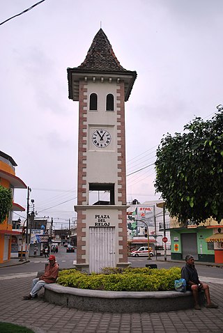
Poza Rica, formally: Poza Rica de Hidalgo is a city and its surrounding municipality in the Mexican state of Veracruz. Its name means "rich well/pond". It is often thought that the name came to be because it was a place known for its abundance of oil. In reality, before oil was discovered, there existed a pond rich in fish, which gave origin to the city’s name. In the 20th century oil was discovered in the area. It has since been almost completely extracted. This has resulted in the decline of oil well exploration and drilling activities, though there are still many oil facilities.
The Totonacan languages are a family of closely related languages spoken by approximately 290,000 Totonac and Tepehua people in the states of Veracruz, Puebla, and Hidalgo in Mexico. At the time of the Spanish conquest Totonacan languages were spoken all along the gulf coast of Mexico. During the colonial period, Totonacan languages were occasionally written and at least one grammar was produced. In the 20th century the number of speakers of most varieties have dwindled as indigenous identity increasingly became stigmatized encouraging speakers to adopt Spanish as their main language.
The Danza de los Voladores, or Palo Volador, is an ancient Mesoamerican ceremony/ritual still performed today, albeit in modified form, in isolated pockets in Mexico. It is believed to have originated with the Nahua, Huastec and Otomi peoples in central Mexico, and then spread throughout most of Mesoamerica. The ritual consists of dance and the climbing of a 30-meter pole from which four of the five participants then launch themselves tied with ropes to descend to the ground. The fifth remains on top of the pole, dancing and playing a flute and drum. According to one myth, the ritual was created to ask the gods to end a severe drought. Although the ritual did not originate with the Totonac people, today it is strongly associated with them, especially those in and around Papantla in the Mexican state of Veracruz. The ceremony was named an Intangible cultural heritage by UNESCO in order to help the ritual survive and thrive in the modern world. The Aztecs believed that Danza de los Voladores was the symbol of their culture.
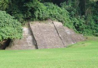
Cuyuxquihui is an archaeological site located in the Tecolutla valley of Veracruz, Mexico, in the region of the Totonac culture, about 22 kilometres (14 mi) southeast of El Tajín or 5 kilometres (3.1 mi) southeast of Paso de Correo.
Tecolutla is a town and municipality located on the Tecolutla River on the eastern coast of the state of Veracruz in Mexico. It has the closest beaches to Mexico City, and much of its economy is based on tourism, as it is only a four- or five-hour drive from the capital. It is the northern end of a tourist corridor along the Gulf of Mexico called the "Emerald Coast," which extends down to the city of Veracruz.
The Sierra Norte de Puebla is a rugged mountainous region accounting for the northern third of the state of Puebla, Mexico. It is at the intersection of the Trans-Mexican Volcanic Belt and the Sierra Madre Oriental, between the Mexican Plateau and the Gulf of Mexico coast. From the Mesoamerican period to the 19th century, this area was part of a larger region called Totonacapan, and area dominated by the Totonac people, extending further east to the Gulf of Mexico. Political maneuvers to weaken the Totonacs led to the region being divided between the modern states of Puebla and Veracruz with the Puebla section given its current name. Until the 19th century, the area was almost exclusively indigenous, with the four main groups still found here today, Totonacs, Nahuas, Otomis and Tepehuas, but coffee cultivation brought in mestizos and some European immigrants who took over political and economic power. While highly marginalized socioeconomically, the area has been developed heavily since the mid 20th century, especially with the building of roadways linking it to the Mexico City area and the Gulf coast.
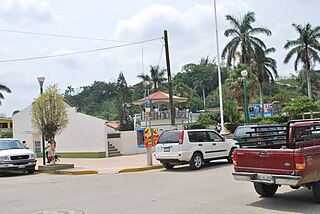
Cazones de Herrera, or Cazones, is a town and municipality located in the north of the Mexican state of Veracruz on the Gulf of Mexico. While it has tourist attractions along its shore, especially in the Barra de Cazones area, the municipality, including the seat, has a high level of socioeconomic marginalization. Most of the municipality's population works in agriculture.
Tihuatlán is a city and its surrounding municipality located in the north of the Mexican state of Veracruz, about 316 km (196 mi) from the state capital Xalapa. The municipality has a surface of 828.29 km2 (319.80 sq mi). The municipality has a population of 92,726 inhabitants as 2020, however, only 16 % resides in the municipal seat.
San Rafael Municipality is a municipality located in the Mexican state of Veracruz. The municipal seat is San Rafael, Veracruz.
Serafin Olarte was a Totonac chief and general who led a revolt against Spanish rule during the Mexican War of Independence in Veracruz.
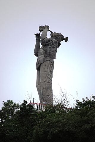
Teodoro Cano Garcia is an artist from Papantla, Veracruz, Mexico who is best known for his mural work depicting the Totonac culture of his native region in northern Veracruz. Cano was discovered by Diego Rivera, who helped Cano as a youth enter the prestigious San Carlos Academy and then employed him as an assistant with the mural work being done at the Ciudad Universitaria in Mexico City. Cano painted his first solo mural in 1953, and since then has produced paintings, murals, sculptures, photography, book illustrations and more, including creating a high relief technique with a cement base. However, Cano is best known for his mural work which depicts and promotes the Totonac culture, and much of his work can be seen in his hometown, including a monumental sculpture of a Volador dancer overlooking the city. Cano also worked as an academic for over 36 years, recently retiring, but he continues to work as an artist based in Xalapa.
Huatusco is an archaeological site located in the Carrillo Puerto municipality, near the small, almost deserted town of Santiago Huatusco, on the northern bank of the Rio Atoyac in the Rancho El Fortin. The importance of the site due to the nearly undamaged pyramid from prehispanic times, the largest part of the actual temple is still standing, in the state of Veracruz, Mexico.
Mesa de Cacahuatenco is a Mesoamerican pre-Columbian archeological site, located in the municipality of Ixhuatlán de Madero in northern Veracruz, Mexico, south of the Vinasca River.
Las Choapas is a recently found archaeological site located within the municipality of Las Choapas, in the southeastern border of the Veracruz State, inside the San Miguel de Allende Ejido, bordering the municipalities of Huimanguillo, Tabasco and Ostuacán, in Chiapas.
The Tecolutla River is a river in the state of Veracruz in Mexico, and the main drainage of the historical and cultural region of Totonacapan. It is principally fed by four rivers that rise in the Sierra Norte de Puebla: from north to south, they are the Necaxa, the Lajajalpan, the Tecuantepec and the Apulco. These rivers converge in the municipality of Espinal, Veracruz, and from here the Tecolutla flows about 100 kilometres (62 mi) east through the coastal plain and the municipalities of Papantla and Gutiérrez Zamora to its mouth at the town of Tecolutla on the Gulf of Mexico, On its south bank the Tecolutla receives the Joloapan River near Paso del Correo, and the Chichicatzapan River via the Ostiones estuary near its mouth.
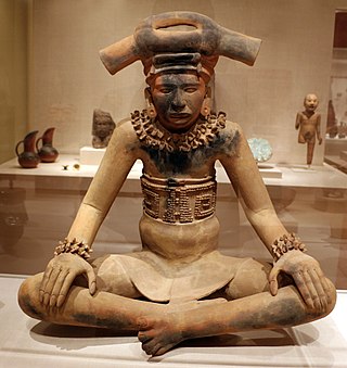
The Totonac culture or Totonec culture was a culture that existed among the indigenous Mesoamerican Totonac people who lived mainly in Veracruz and northern Puebla. Originally, they formed a confederation of cities, but, in later times, it seems that they were organized in three dominions: North, South and Serran. Its economy was agricultural and commercial. They had large urban centers such as: El Tajín (300–1200), which represents the height of the Totonac culture, Papantla (900–1519) and Cempoala (900–1519).
1 2 3 4 5 6 7 8 9 10 11 Masferrer Kan, Elio (2004). Totonacos (in Spanish). Mexico: Comisión Nacional para el Desarrollo de los Pueblos Indígenas and Programa de las Naciones Unidas para el Desarrollo. ISBN970-753-025-1. Retrieved May 9, 2012.
↑ Elio Roberto Masferrer Kan. "Tercera parte"(PDF). Cambios y Continuidad Entre los Totonacos de la Sierra Norte de Puebla (MA). Universidad Iberoamericana. Retrieved March 22, 2012.
↑ "Regionalización"[Regions]. Enciclopedia de los Municipios y Delegaciones de México - Veracruz (in Spanish). Mexico: Instituto para el Federalismo y el Desarrollo Municipal and Secretaría de Gobernación. 2010. Archived from the original on May 17, 2011. Retrieved May 9, 2012.
↑ Wilkerson, S. Jeffery K. (1987). El Tajin: A Guide for Visitors. pp.72–73. ISBN968-499-293-9.
↑ María Elena Ferral (November 23, 2008). "Mejora comunicación en el Totonacapan"[Improve communications in Totonacapan]. Diario de Xalapa (in Spanish). Xalapa, Veracruz. Retrieved May 9, 2012.
1 2 3 Núñez, Cecilia (June 14, 2009). "Veracruz con olor a vainilla" [Veracruz with the smell of vanilla]. Reforma (in Spanish). Mexico City. p.7.
↑ López Ibarra, Luis Angel (October 25, 2007). "Negocio sabor vainilla" [Business with vanilla flavor]. Economista (in Spanish). Mexico City.
This page is based on this Wikipedia article Text is available under the CC BY-SA 4.0 license; additional terms may apply. Images, videos and audio are available under their respective licenses.