
Traralgon is a town located in the east of the Latrobe Valley in the Gippsland region of Victoria, Australia and the most populous city in the City of Latrobe and the region. The urban population of Traralgon at the 2021 census was 26,907. It is the largest and fastest growing city in the greater Latrobe Valley area, which has a population of 77,168 at the 2021 Census and is administered by the City of Latrobe.

Morwell is a town in the Latrobe Valley area of Gippsland, in South-Eastern Victoria, Australia approximately 152 km (94 mi) east of Melbourne.

The Latrobe Valley is an inland geographical district and urban area of the Gippsland region in the state of Victoria, Australia. The traditional owners are the Brayakaulung of the Gunai nation. The district lies east of Melbourne and nestled between the Strzelecki Ranges to the south and the Baw Baw Ranges, part of the Great Dividing Range, to the north. Mount St Phillack is the highest peak to the north of the Latrobe Valley, due north of Moe. The highest peak to the south is Mt Tassie, south of Traralgon.
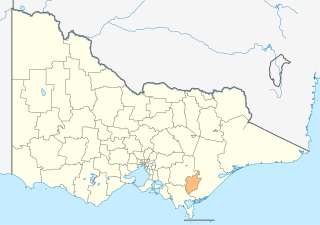
The City of Latrobe is a local government area in the Gippsland region in eastern Victoria, Australia, located in the eastern part of the state. It covers an area of 1,426 square kilometres (551 sq mi) and in June 2018 had a population of 75,211. It is primarily urban with the vast majority of its population living within the four major urban areas of Moe, Morwell, Traralgon, and Churchill, and other significant settlements in the LGA include Boolarra, Callignee, Glengarry, Jeeralang, Newborough, Toongabbie, Tyers, Yallourn North and Yinnar. It was formed in 1994 from the amalgamation of the City of Moe, City of Morwell, City of Traralgon, Shire of Traralgon, and parts of the Shire of Narracan and Shire of Rosedale. The Yallourn Works Area was added in 1996. When formed, the municipality was called the Shire of La Trobe, but on 6 April 2000, it adopted its current name.

Haileybury is a private school with campuses in Keysborough, Brighton East, Berwick, Darwin, Northern Territory and Melbourne's CBD. It also has an international campus in the Tianjin outer district of Wuqing, China. Haileybury operates under the model of parallel education, which consists of Haileybury College and Haileybury Girls College. Haileybury has been described as the largest independent school in Australia.

Princes Freeway is a 159-kilometre (99 mi) Australian freeway, divided into two sections, both located in Victoria, Australia. The freeway links Melbourne to Geelong in the west, and to Morwell in the east. It continues beyond these extremities as the Princes Highway towards Adelaide to the west and Sydney to the northeast. The freeway bears the designation M1.

Caulfield Grammar School is a private, co-educational, Anglican, International Baccalaureate, day and boarding school, located in Melbourne, Victoria, Australia. Founded in 1881 as a boys' school, Caulfield Grammar began admitting girls exactly one hundred years later. The school amalgamated with Malvern Memorial Grammar School (MMGS) in 1961, with the MMGS campus becoming Malvern Campus.

Moe is a town in the Latrobe Valley in the Gippsland region of Victoria, Australia. It is approximately 130 kilometres east of the central business district of Melbourne, 45 kilometres due south of the peak of Mount Baw Baw in the Great Dividing Range and features views of the Baw Baw Ranges to the north and Strzelecki Ranges to the south.

Kardinia International College is a private K-12 school located in Bell Post Hill, Geelong, Victoria, Australia. It is a triple campus college, residing on the site of the former Morongo Girls' College and has two other campuses, one in Lovely Banks, Geelong and another located in Chiang Mai, Thailand. Enrolment across the school is usually around 1800 full time students.

Victoria is a state in southeastern Australia. It is the second-smallest state, with a land area of 227,444 km2 (87,817 sq mi); the second-most-populated state, with a population of over 6.7 million; and the most densely populated state in Australia. Victoria is bordered by New South Wales to the north and South Australia to the west, and is bounded by the Bass Strait to the south, the Great Australian Bight portion of the Southern Ocean to the southwest, and the Tasman Sea to the southeast. The state encompasses a range of climates and geographical features from its temperate coastal and central regions to the Victorian Alps in the northeast and the semi-arid north-west.
Federation University Australia Gippsland Campus is an Australian university campus located in the town of Churchill 142 km east of Melbourne. Its main neighbouring towns in the region are Morwell and Traralgon. Formerly a branch of Monash University, on 1 January 2014 it became part of Federation University Australia. Study areas at the campus include Arts ; Business; Education; Information Technology; Nursing; Midwifery; Sport, Outdoor and Physical Education; Psychology; Science; Engineering and Visual Arts.
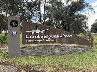
Latrobe Regional Airport is located between the Latrobe Valley towns of Morwell and Traralgon, Victoria, Australia. The airport is about 160 kilometres east of Melbourne, off the Princes Highway, 4 nautical miles west of Traralgon.

Essendon Keilor College was founded in 1992 from the amalgamation of Queens Park Secondary College, Essendon High School, Niddrie High School and Keilor Heights Secondary College.

Lavalla Catholic College is a dual-campus independent Roman Catholic co-educational secondary day school, located in the towns of Traralgon and Newborough in the Gippsland region of Victoria, Australia. Currently, the school has approximately 1,200 students enrolled across all campuses.

The Gippsland League is an Australian rules football and netball league in the Gippsland region of Victoria, Australia. It is considered the only AFL Victoria major league in Gippsland.
Willow Grove is a town and rural farming community located in the Baw Baw foothills. It is northwest of Moe in Victoria, Australia and North of Trafalgar. It has a primary school, football club, tennis courts, community hall, general store, CFA shed, and kindergarten. It is a popular tourist destination where people can enjoy trail bike riding, camping, four wheel driving & hunting. The next town to the west is Hill End and to the east Tanjil South. Willow Grove is situated within the Shire of Baw Baw and shares the postcode 3825. At the 2006 census, Willow Grove and the surrounding area had a population of 221.
Chairo Christian School is a multi-campus co-educational private, non-denominational Christian School with campuses in Drouin, Victoria, Drouin East, Pakenham, Victoria, Leongatha, Victoria, and Traralgon, Victoria.
The Kelso High Campus of Denison College of Secondary Education is a government-funded co-educational comprehensive secondary day school campus, located in Kelso, in the Central West region of New South Wales, Australia.
Churchill is a town in the Latrobe Valley, located in central Gippsland in the east of Victoria, Australia. The town had a population of 4,568 at the 2016 census, and is part of the Latrobe City local government area. The town was named in honour of former British prime minister Sir Winston Churchill, who had died earlier in the year the town's establishment was announced.
Evelyn Maude "Eva" West was an Australian accountant and local government administrator.

