Trentwood, Washington

Last updated
Trentwood, Washington
Locale
Spokane County Washington Incorporated and Unincorporated areas Trentwood Highlighted.svg
Location of Trentwood, Washington
Coordinates: 47°41′59″N117°12′39″W / 47.69972°N 117.21083°W / 47.69972; -117.21083
CountryUnited States
State Washington
County Spokane
Area
  Total1.8 sq mi (4.6 km2)
  Land1.8 sq mi (4.6 km2)
  Water0.0 sq mi (0.0 km2)
Elevation
2,028 ft (618 m)
Population
 (2000)
  Total4,388
  Density2,482.2/sq mi (958.4/km2)
Time zone UTC-8 (Pacific (PST))
  Summer (DST) UTC-7 (PDT)
FIPS code 53-72310 [1]
GNIS feature ID1512737 [2]

Trentwood is a locale and former census-designated place (CDP) in Spokane County, Washington, United States, east across the Spokane River from Irwin. The population was 4,388 at the 2000 census. Trentwood joined the other unincorporated communities in the region to form the city of Spokane Valley in 2003.

Contents

History

Trentwood was originally called East Trent because of its position across the Spokane River from Irwin, formerly named Trent. Rather than a centralized town, East Trent was a loose collection of communities including a rail station named Steno, after a local court stenographer, and Trentwood Orchards, so named because of an economy of lumber and fruit trees. In 1917, after the stenographer died as well as many of the fruit trees, the railroad and communities came together under the name Trentwood. [3]

Geography

Trentwood is located at 47°41′59″N117°12′39″W / 47.69972°N 117.21083°W / 47.69972; -117.21083 (47.699595, -117.210791). [4]

According to the United States Census Bureau, the CDP had a total area of 1.8 square miles (4.7 km2), of which, 1.8 square miles (4.7 km2) is land and 0.56% is water.

Demographics

As of the census [1] of 2000, there were 4,388 people, 1,546 households, and 1,179 families residing in the CDP. The population density was 2,482.2 per square mile (958.4/km2). There were 1,632 housing units at an average density of 923.2 per square mile (356.4/km2). The racial makeup of the CDP was 92.68% White, 0.71% African American, 1.07% Native American, 2.71% Asian, 0.11% Pacific Islander, 0.71% from other races, and 2.01% from two or more races. Hispanic or Latino of any race were 2.39% of the population.

There were 1,546 households, out of which 42.6% had children under the age of 18 living with them, 57.2% were married couples living together, 13.8% had a female householder with no husband present, and 23.7% were non-families. 18.2% of all households were made up of individuals, and 4.4% had someone living alone who was 65 years of age or older. The average household size was 2.82 and the average family size was 3.20.

In the CDP, the age distribution of the population shows 31.1% under the age of 18, 8.5% from 18 to 24, 31.4% from 25 to 44, 21.9% from 45 to 64, and 7.2% who were 65 years of age or older. The median age was 34 years. For every 100 females, there were 104.2 males. For every 100 females age 18 and over, there were 100.9 males.

The median income for a household in the CDP was $41,128, and the median income for a family was $45,455. Males had a median income of $31,968 versus $25,368 for females. The per capita income for the CDP was $16,566. About 7.9% of families and 8.6% of the population were below the poverty line, including 8.3% of those under age 18 and 14.1% of those age 65 or over.

Related Research Articles

<span class="mw-page-title-main">Loughman, Florida</span> Census-designated place in Florida, United States

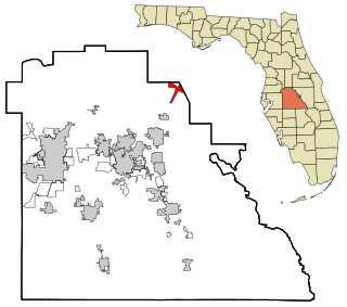
Loughman (LOFF-mǝn) is a census-designated place (CDP) in the northeast corner of Polk County, Florida, United States, near the Osceola county line. The population was 1,385 at the 2000 census. It is part of the Lakeland–Winter Haven Metropolitan Statistical Area. This area has grown rapidly since 2000 due, in large part, to its proximity to Walt Disney World and the Orlando, Florida area.

Pistakee Highlands is a census-designated place (CDP) in McHenry County, Illinois, United States. It consists primarily of an unincorporated area of McHenry County adjoining Pistakee Bay, within the McHenry post office, and is located just northeast of Johnsburg. Per the 2020 census, the population was 3,237.

<span class="mw-page-title-main">Fairmont, Illinois</span> Census-designated place in Illinois, United States

Fairmont is a census-designated place (CDP) in Will County, Illinois, United States. The population was 2,389 at the 2020 census.

<span class="mw-page-title-main">Yarmouth Port, Massachusetts</span> Census-designated place in Massachusetts, United States

Yarmouth Port is a census-designated place (CDP) in the town of Yarmouth in Barnstable County, Massachusetts, United States. The population was 5,320 at the 2010 census.

<span class="mw-page-title-main">Nakaibito, New Mexico</span> CDP in New Mexico, United States

Nakaibito is a census-designated place (CDP) in McKinley County, New Mexico, United States. The population was 455 at the 2000 census.

Brices Creek is an unincorporated area and census-designated place (CDP) in Craven County, North Carolina, United States. The population was 3,073 at the 2010 census. It is part of the New Bern, North Carolina Metropolitan Statistical Area.

<span class="mw-page-title-main">South Huntingdon Township, Westmoreland County, Pennsylvania</span> Township in Pennsylvania, United States

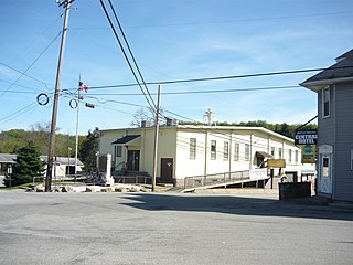
South Huntingdon Township is a township in Westmoreland County, Pennsylvania, United States. The population was 5,412 at the 2020 census.

<span class="mw-page-title-main">Fairburn, South Dakota</span> Town in South Dakota, United States

Fairburn is a town in Custer County, South Dakota, United States. The population was 60 at the 2020 census.

Villa Heights is a census-designated place (CDP) in Henry County, Virginia, United States. The population was 717 at the 2010 census. It is part of the Martinsville Micropolitan Statistical Area.

<span class="mw-page-title-main">Clarkston Heights-Vineland, Washington</span> CDP in Washington, United States

Clarkston Heights-Vineland is a census-designated place (CDP) in Asotin County, Washington, United States. It is part of the Lewiston, ID–WA Metropolitan Statistical Area. The population was 7,275 at the 2020 census.

<span class="mw-page-title-main">Country Homes, Washington</span> CDP in Washington, United States

Country Homes is a census-designated place (CDP) in Spokane County, Washington, United States. The population was 6,251 at the 2020 census. The campus of Whitworth University is located in Country Homes.

<span class="mw-page-title-main">Dishman, Washington</span> Locale in Washington, United States

Dishman is a locale and former census-designated place (CDP) in Spokane County, Washington, United States. Founded by Addison T. Dishman (II), who operated a nearby rock quarry in 1889, its population was 10,031 at the 2000 census. Dishman has been part of Spokane Valley since 2003.

<span class="mw-page-title-main">Fairwood, Spokane County, Washington</span> CDP in Washington, United States

Fairwood is a census-designated place (CDP) in Spokane County, Washington, United States. The population was 10,541 at the 2020 census.

<span class="mw-page-title-main">Greenacres, Washington</span> Locale in Washington, United States

Greenacres is a locale and former census-designated place (CDP) in Spokane County, Washington, United States. The locale is almost entirely split between the city of Spokane Valley and unincorporated Spokane County, with a small portion being located within the city of Liberty Lake. Greenacres retains its own post office.

<span class="mw-page-title-main">Liberty Lake, Washington</span> City in Washington, United States

Liberty Lake is a city in Spokane County, Washington, United States located adjacent to the eponymous lake. Located just over a mile west of the Washington–Idaho border, Liberty Lake is both a suburb of Spokane, Washington and a bedroom community to Coeur d'Alene, Idaho. The population was 12,003 at the 2020 census.

<span class="mw-page-title-main">Millwood, Washington</span> City in Washington, United States

Millwood is a city in Spokane County, Washington, United States. The population was 1,786 at the 2010 census. Millwood is a suburb of Spokane, and is surrounded on three sides by the city of Spokane Valley. The Spokane River flows along the northern edge of the city. The city is home to the National Register of Historic Places listed Millwood Historic District.

<span class="mw-page-title-main">Opportunity, Washington</span> Locale in Washington, United States

Opportunity is a locale and former census-designated place in Spokane County, Washington, United States. The population was 25,065 at the 2000 census.

<span class="mw-page-title-main">Otis Orchards-East Farms, Washington</span> CDP in Washington, United States

Otis Orchards-East Farms is a census-designated place (CDP) in Spokane County, Washington, United States, near the county's border with Idaho. The population was 6,299 at the 2020 census. The CDP includes the unincorporated communities of Otis Orchards and East Farms. Otis Orchards contains the bulk of the businesses of the community.

<span class="mw-page-title-main">Veradale, Washington</span> Locale in Washington, United States

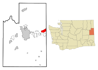
Veradale—originally known as Vera—is a locale and former census-designated place in Spokane County, Washington, United States. The population was 9,387 at the 2000 census. Veradale retains its own post office.

<span class="mw-page-title-main">Loveland Park, Ohio</span> Census-designated place in Ohio, United States

Loveland Park is a census-designated place (CDP) located in Symmes Township, Hamilton County and Deerfield Township, Warren County, in the southwestern part of the U.S. state of Ohio. The CDP is named after the city of Loveland. The population was 1,737 at the 2020 census.

References

  1. 1 2 "U.S. Census website". United States Census Bureau . Retrieved 2008-01-31.
  2. "US Board on Geographic Names". United States Geological Survey. 2007-10-25. Retrieved 2008-01-31.
  3. Phillips, James Wendell (1971). Washington State place names. Seattle: University of Washington Press. p. 146.
  4. "US Gazetteer files: 2010, 2000, and 1990". United States Census Bureau. 2011-02-12. Retrieved 2011-04-23.