Cochabamba, from Quechua qucha or qhucha, meaning "lake", pampa meaning "plain", is one of the nine departments of Bolivia. It is known to be the "granary" of the country because of its variety of agricultural products from its geographical position. It has an area of 55,631 km2. Its population in the 2012 census was 1,758,143. Its capital is the city of Cochabamba, known as the "City of Eternal Spring" and "The Garden City" because of its spring-like temperatures all year.
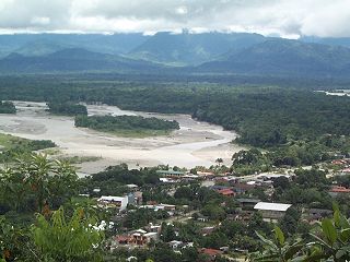
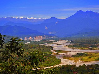
Chapare (Spanish:[tʃaˈpaɾe], also called The Chapare, is a rural province in the northern region of Cochabamba Department in central Bolivia. Most of the territory consists of valley rainforests that surround the area's main waterway, the Chapare River, which is also a tributary of the Amazon River. The provincial capital is Sacaba, 11 km east of Cochabamba. Its principal town is Villa Tunari, a popular tourist destination.

Ayopaya is a province in the Cochabamba Department, Bolivia. Its capital is Ayopaya.

Quillacollo is a province in the Cochabamba Department, Bolivia. It is known for its festival in August where people from all over Bolivia come and pay homage to the Virgin of Urqupiña. Quillacollo is said to be one of the fastest-growing cities in Bolivia.
Moxos is a province in the Beni Department, Bolivia. It is named after the Moxos savanna.

Madidi is a national park in the upper Amazon river basin in Bolivia. It was established in 1995 with a total land area of 18,958 km2. Together with the nearby protected areas Manuripi-Heath and Apolobamba and the Manu Biosphere Reserve (Peru), Madidi is part of one of the largest protected areas in the world.

The Cordillera Oriental or Eastern Cordillera is a set of parallel mountain ranges of the Bolivian Andes, emplaced on the eastern and north eastern margin of the Andes. Large parts of Cordillera Oriental are forested and humid areas rich in agricultural and livestock products. Geologically, the Cordillera Oriental is formed by the Central Andean fold and thrust belt.
Villa Tunari or Tunari is a location in the department of Cochabamba, Bolivia. It is the seat of the Villa Tunari Municipality, the third municipal section of the Chapare Province. According to the census 2012 the population was 3,213 in the town which is an increment from 2,510 registered during the 2001 census.
Bolivia's drinking water and sanitation coverage has greatly improved since 1990 due to a considerable increase in sectoral investment. However, the country continues to suffer from what happens to be the continent's lowest coverage levels and from low quality of services. Political and institutional instability have contributed to the weakening of the sector's institutions at the national and local levels. Two concessions to foreign private companies in two of the three largest cities—Cochabamba and La Paz/El Alto—were prematurely ended in 2000 and 2006 respectively. The country's second largest city, Santa Cruz de la Sierra, relatively successfully manages its own water and sanitation system by way of cooperatives. The government of Evo Morales intends to strengthen citizen participation within the sector. Increasing coverage requires a substantial increase of investment financing.
The Chapare River is a river in Bolivia, which is a tributary of the Mamoré River in the Amazon Basin. The river has its source at the confluence of Espíritu Santo River and San Mateo River in the Cochabamba Department at Villa Tunari. It is the main waterway of Chapare Province in central Bolivia.
The privatization of water supply and sanitation in Bolivia took place during the second mandate of Bolivian President Hugo Banzer (1997-2001) in the form of two major private concessions: one in La Paz/El Alto to Aguas del Illimani S.A. (AISA), a subsidiary of the French Suez in 1997; and a second one in Cochabamba to Aguas del Tunari, a subsidiary of the multinationals Biwater and Bechtel in 1999.

The Cochabamba Water War, also known as the Bolivian Water War, was a series of protests that took place in Cochabamba, Bolivia's fourth largest city, between December 1999 and April 2000 in response to the privatization of the city's municipal water supply company SEMAPA. The wave of demonstrations and police violence was described as a public uprising against water prices.

Isiboro Sécure National Park and Indigenous Territory is a protected area and Native Community Land in Bolivia situated between the north of the Cochabamba Department and the south of the Beni Department. It protects part of the Bolivian Yungas ecoregion. The indigenous people living within the park belong to the Tsimané, Yuracaré, and Mojeño-Trinitario peoples. The southern portion of the park has been colonized by agricultural settlers, primarily coca farmers, since the 1970s. The Bolivian government estimates that 10% of the park has been deforested by their presence.
Entre Ríos is a small town in the Cochabamba Department of the South American Republic of Bolivia.

Quillacollo Municipality is the first municipal section of the Quillacollo Province in the Cochabamba Department, Bolivia. Its capital is Quillacollo. At the time of census 2001 the municipality had 104,206 inhabitants.

Villa Tunari Municipality is the third municipal section of the Chapare Province in the Cochabamba Department, Bolivia. Its seat is Villa Tunari. The population grew from 52,886 to 71,146 during 2001 to 2012 according to the census. Only 8,692 of the population are urban and are concentrated in the small towns of Villa Tunari (3.213), Eterazama (3,359) and Villa 14 the Septiembre (2,123). The municipality is famous for tourist especially the Villa Tunari town where the tourist industry is concentrated with infrastructure, and also because of the closeness of the Machia Park.
Vinto Municipality is the fourth municipal section of the Quillacollo Province in the Cochabamba Department, Bolivia. Its seat is Vinto.

The Villa Tunari – San Ignacio de Moxos Highway, also known as the Cochabamba–Beni Highway is a road project in Bolivia connecting the towns of Villa Tunari and San Ignacio de Moxos. It would provide the first direct highway link between the two departments. The project has an expected overall cost of $415 million and extends 306 kilometres (190 mi), divided into three segments: Segment I from Villa Tunari to Isinuta, Segment II from Isinuta to Monte Grande, and Segment III from Monte Grande to San Ignacio de Moxos. Opposition to the highway by local indigenous communities, environmentalists, as well as shifting relations between the Bolivian government and the project's builders and funders interrupted construction of Segment I from October 2011 until October 2013, indefinitely delayed Segment II, and postponed construction of Segment III until June 2015. Segment II will proceed after the government has promised to raise living standards in the area.
The Pact of Unity is an evolving national alliance of Bolivian grassroots organizations in support of indigenous and agrarian rights, land reform, the rewriting of the 1967 constitution through a Constituent Assembly, and a left-indigenous transformation of the Bolivian state. Since 2005, the Pact has been a close ally of Bolivian President Evo Morales, and it forms the nucleus of the National Coordination for Change, a pro-government alliance.

The Misicuni Multiplepurpose Project, better known as the Misicuni Dam, is a concrete-face rock-fill dam constructed on the Misicuni River about 35 km (22 mi) northwest of the city of Cochabamba, Bolivia. The dam will divert water from the Misicuni River to the Cochabamba Valley for several purposes to include providing water for irrigation and municipal water uses. In addition, the dam has an associated 120 MW hydroelectric power station, powered by 3 turbines 40 MW each. Construction on the dam began in June 2009 but was halted in November 2013 due to contract disputes. The company finished the construction and is started the operations in September 2017.
