
Flagstaff is a city in, and the county seat of Coconino County, Arizona, in the southwestern United States. As of the 2020 United States census, the population was 76,831.

Coconino County is a county in the north-central part of the U.S. state of Arizona. Its population was 145,101 at the 2020 census. The county seat is Flagstaff. The county takes its name from Cohonino, a name applied to the Havasupai people. It is the second-largest county by area in the contiguous United States, behind San Bernardino County, California. It has 18,661 sq mi (48,300 km2), or 16.4% of Arizona's total area, and is larger than the nine smallest states in the U.S.

The Coconino National Forest is a 1.856-million acre United States National Forest located in northern Arizona in the vicinity of Flagstaff, with elevations ranging from 2,600 feet to the highest point in Arizona at 12,633 feet. Originally established in 1898 as the "San Francisco Mountains National Forest Reserve", the area was designated a U.S. National Forest by Pres. Theodore Roosevelt on July 2, 1908, when the San Francisco Mountains National Forest Reserve was merged with lands from other surrounding forest reserves to create the Coconino National Forest. Today, the Coconino National Forest contains diverse landscapes, including deserts, ponderosa pine forests, flatlands, mesas, alpine tundra, and ancient volcanic peaks. The forest surrounds the towns of Sedona and Flagstaff and borders four other national forests; the Kaibab National Forest to the west and northwest, the Prescott National Forest to the southwest, the Tonto National Forest to the south, and the Apache-Sitgreaves National Forest to the southeast. The forest contains all or parts of nine designated wilderness areas, including the Kachina Peaks Wilderness, which includes the summit of the San Francisco Peaks. The headquarters are in Flagstaff. The Coconino National Forest consists of three districts: Flagstaff Ranger District, Mogollon Rim Ranger District, and Red Rock Ranger District, which have local ranger district offices in Flagstaff, Happy Jack, and Sedona.
Kendrick Mountain Wilderness is a 6,510-acre (26.3 km2) wilderness area in the U.S. State of Arizona. It lies north of the city of Flagstaff on the Coconino Plateau in Coconino County. Kendrick Mountain Wilderness was designated a protected Wilderness area by Congress in 1984. About two thirds of the wilderness is contained within the Kaibab National Forest. Kendrick Mountain Wilderness contains 10,418-foot (3,175 m) Kendrick Peak, upon which a fire lookout has been located since the early 1900s.

Oak Creek Canyon is a river gorge located in northern Arizona between the cities of Flagstaff and Sedona. The canyon is often described as a smaller cousin of the Grand Canyon because of its scenic beauty. State Route 89A enters the canyon on its north end via a series of hairpin turns before traversing the bottom of the canyon for about 13 miles (21 km) until the highway enters the town of Sedona.

U.S. Route 89 (US 89) is a U.S. Highway in the U.S. state of Arizona that begins in Flagstaff and heads north to the Utah border northwest of Page. US 89 is among the first U.S. Highways established in Arizona between November 11, 1926 and September 9, 1927. Until 1992, US 89 started at the international border in Nogales and was routed through Tucson, Phoenix and Prescott between Nogales and Flagstaff. State Route 79 and State Route 89 are both former sections of US 89.

The 2009 California wildfires were a series of 9,159 wildfires that were active in the US state of California, during the year 2009. The fires burned more than 422,147 acres of land from early February through late November, due to Red Flag conditions, destroying hundreds of structures, injuring 134 people, and killing four. The wildfires also caused at least US$134.48 million in damage. Although the fires burned many different regions of California in August, the month was especially notable for several very large fires which burned in Southern California, despite being outside of the normal fire season for that region.

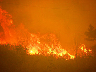
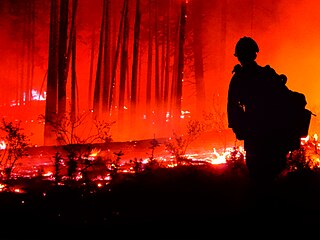
The Schultz Fire was a wildfire which burned over 15,000 acres (6,100 ha), including Schultz Peak in Coconino National Forest near Flagstaff, Arizona, in June 2010. The suspected cause is a campfire left unattended, and the United States Forest Service is offering a $2500 reward for information.
The 2012 Colorado wildfires were an unusually devastating series of Colorado wildfires, including several separate fires that occurred throughout June, July, and August 2012. At least 34,500 residents were evacuated in June.

The Tinder Fire was a wildfire that burned 16,309 acres (6,600 ha) of the Coconino National Forest in the U.S. state of Arizona during April and May 2018. The fire was detected by a United States Forest Service (USFS) lookout tower on April 27, 2018, and firefighters began working to contain its spread within the day. Benefiting from strong winds, low humidity, and high temperatures, the fire grew rapidly over late April, prompting the closure of Arizona State Route 87 and evacuation orders for 1,000 houses in Coconino County. These orders remained until May 4. Almost 700 firefighters were involved in combating the fire, which was fully contained on May 24. The investigation into the fire determined that the Tinder Fire was caused by a prohibited campfire.

Woodbury Fire was a wildfire in the Superstition Wilderness, northwest of Superior, Arizona, that started on June 8, 2019. The fire burned a total area of 123,875 acres. It was the fifth largest wildfire in Arizona’s history. The blaze caused the evacuation of homes, road and campground closures, endangered wildlife habitats, and the destruction of hiking trails and archaeological sites.

The Goodwin Fire was a wildfire that burned 28,516 acres (11,540 ha) in the U.S. state of Arizona over 16 days, from June 24 to July 10, 2017. The fire destroyed 17 homes and damaged another 19 structures, but no firefighters or civilians were injured or died in the fire. Investigators did not determine any particular cause for the fire.

The 2021 Arizona wildfire season was a series of wildfires that burned across the state of Arizona, United States. Wildfires across the state burned 524,428 acres (212,228 ha) of land in at least 1,773 fires throughout the state, fueled in part by a drought, hot temperatures, and thunderstorms producing dry lightning. At one point in late June, over 20 active wildfires were burning across the state.

The Rafael Fire was a wildfire that started near Perkinsville, Arizona on June 18, 2021. The fire has burned 78,065 acres (31,592 ha) and was fully contained on July 15, 2021.

The Backbone Fire was a wildfire that started near Payson, Arizona on June 16, 2021. The fire burned 40,855 acres (16,533 ha) was fully contained on July 19, 2021.

The 2020 Maricopa County wildfires were a series of major and non-major wildfires that took place in Maricopa County, Arizona, from the month of May to the month of October. In the year 2020, Arizona saw one of its worst fire seasons in the states history. Due to the lack of precipitation needed in Arizona, the state fell into an ongoing drought from late 2020 and 2021. High winds were also present during the summer when fire season is mostly active in the state. These factors led to the wildfires in Maricopa County to be destructive and costly.
This article is a summary of the 2022 Arizona wildfire season, comprising the series of significant wildfires that burned in the U.S. state of Arizona during the calendar year 2022. According to statistics published by the Southwest Coordination Center, a total of 1,263 fires burned a total of 143,601 acres in Arizona in 2022.
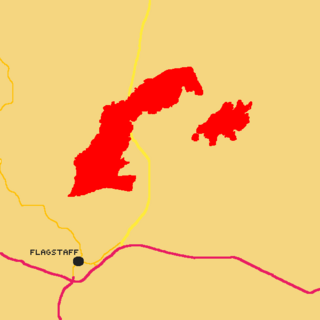
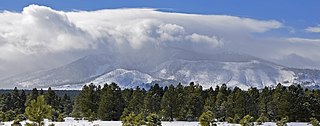
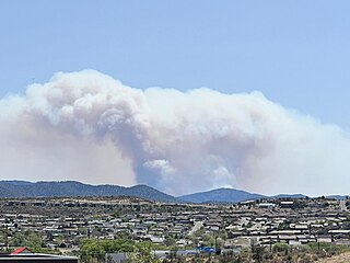
The June 2022 Flagstaff wildfires was a series of wildfires burning near the city of Flagstaff, Arizona. At least three wildfires were reported near Flagstaff and caused hundreds of people to evacuate. However, two of the three reported fires, which are the Haywire and Double fires, combined on June 13. Before the merger of both of the fires, the Double Fire burned 500 acres (200 ha). The first wildfire to be discovered was the Pipeline Fire on June 12 at around 10:15 AM (MST); By Monday evening on June 13, the fire burned 5,000 acres (2,000 ha). As of June 13, 2022, no injuries or deaths have been reported, and one structure has been destroyed.
The Boundary Fire was a wildfire that burned 17,788 acres (7,199 ha) of the Coconino and Kaibab National Forests in Arizona. The fire was ignited on June 1 when lightning struck a spot on the northeast side of Kendrick Peak within the Coconino National Forest. The Boundary Fire immediately began producing smoke that could be seen from the Grand Canyon, which was blown by high winds that also fanned the fire itself over local communities and infrastructure. The fire burned out on July 3, 2017.

