Turrell, Arkansas

Last updated
Turrell, Arkansas
Turrell AR 07.jpg
Downtown Turrell
Crittenden County Arkansas Incorporated and Unincorporated areas Turrell Highlighted 0570430.svg
Location of Turrell in Crittenden County, Arkansas.
Coordinates: 35°22′20″N90°16′17″W / 35.37222°N 90.27139°W / 35.37222; -90.27139
Country United States
State Arkansas
County Crittenden
Area
[1]
  Total5.36 sq mi (13.89 km2)
  Land5.35 sq mi (13.85 km2)
  Water0.02 sq mi (0.05 km2)
Elevation
[2]
220 ft (70 m)
Population
 (2020)
  Total517
  Density96.71/sq mi (37.34/km2)
Time zone UTC-6 (Central (CST))
  Summer (DST) UTC-5 (CDT)
ZIP code
72384
Area code 870
FIPS code 05-70430
GNIS feature ID2405613 [2]

Turrell is a city in Crittenden County, Arkansas, United States. Per the 2020 census, the population was 517. [3]

Contents

Geography

Turrell is located in northern Crittenden County and is bordered by the town of Gilmore to the north. Turrell is located on Arkansas Highway 77, just southeast of the junction where Interstate 55 and U.S. Routes 61 merge. Prior to 2021, US 63 merged here too. Interstate 55 leads south 24 miles (39 km) to Memphis, Tennessee, and north 42 miles (68 km) to Blytheville, Arkansas, near the Missouri border. US 61/Interstate 555 leads northwest 45 miles (72 km) to Jonesboro.

The Burlington Northern-Santa Fe Railroad runs through Turrell. Two major lines of the Burlington Northern-Santa Fe Springfield Division converge at Turrell (the Thayer South and the River subdivisions), which funnel trains from the Springfield, Missouri, yard and the St. Louis yard, respectively, to Turrell. Once these two lines converge, the trackage then goes to Memphis. The railroad was formerly the St. Louis–San Francisco Railway (better known as the Frisco). The Frisco Railroad was absorbed by the Burlington Northern in 1980.

According to the United States Census Bureau, Turrell has a total area of 5.4 square miles (14.0 km2), of which 0.02 square miles (0.05 km2), or 0.33%, is water. [4]

Demographics

Historical population
CensusPop.Note
1930 456
1940 51512.9%
1950 67030.1%
1960 79418.5%
1970 783−1.4%
1980 1,04133.0%
1990 988−5.1%
2000 957−3.1%
2010 615−35.7%
2020 517−15.9%
U.S. Decennial Census [5]
2010 [6] 2020 [7]

2020 census

Turrell city, Arkansas – Racial and ethnic composition
Note: the U.S. census treats Hispanic/Latino as an ethnic category. This table excludes Latinos from the racial categories and assigns them to a separate category. Hispanics/Latinos may be of any race.
Race / Ethnicity (NH = Non-Hispanic)Pop 2010 [6] Pop 2020 [7] % 2010% 2020
White alone (NH)873414.15%6.58%
Black or African American alone (NH)52345885.04%88.59%
Native American or Alaska Native alone (NH)000.00%0.00%
Asian alone (NH)010.00%0.19%
Pacific Islander alone (NH)000.00%0.00%
Some Other Race alone (NH)000.00%0.00%
Mixed Race or Multi-Racial (NH)3120.49%2.32%
Hispanic or Latino (any race)2120.33%2.32%
Total615517100.00%100.00%

2000 Census

As of the census [8] of 2000, there were 957 people, 326 households, and 222 families residing in the town. The population density was 176.1 inhabitants per square mile (68.0/km2). There were 357 housing units at an average density of 65.7 per square mile (25.4/km2). The racial makeup of the city was 19.44% White, 78.79% Black or African American, 0.10% Native American, 0.94% from other races, and 0.73% from two or more races. 2.93% of the population were Hispanic or Latino of any race.

There were 326 households, out of which 30.7% had children under the age of 18 living with them, 32.5% were married couples living together, 29.1% had a female householder with no husband present, and 31.9% were non-families. 27.6% of all households were made up of individuals, and 11.7% had someone living alone who was 65 years of age or older. The average household size was 2.94 and the average family size was 3.70.

In the town, the population was spread out, with 34.1% under the age of 18, 8.7% from 18 to 24, 23.6% from 25 to 44, 21.4% from 45 to 64, and 12.2% who were 65 years of age or older. The median age was 33 years. For every 100 females, there were 90.6 males. For every 100 females age 18 and over, there were 79.3 males.

The median income for a household in the town was $15,000, and the median income for a family was $21,750. Males had a median income of $26,250 versus $14,861 for females. The per capita income for the town was $8,908. About 38.1% of families and 41.0% of the population were below the poverty line, including 50.8% of those under age 18 and 30.4% of those age 65 or over.

Education

Public education for early childhood, elementary and secondary school students is primarily provided by the Marion School District, [9] which leads to graduation from Marion High School.

On July 1, 2010, [10] the former Turrell School District consolidated with the Marion School District, thus closing the former Turrell High School. [11] The Turrell High School mascot was the Rockets and its boys basketball teams won two consecutive Class A state basketball championships in 1999 and 2000 and the girls won the state title in 1987.

Notable person

Related Research Articles

<span class="mw-page-title-main">Smyth County, Virginia</span> County in Virginia, United States

Smyth County is a county located in the U.S. state of Virginia. As of the 2020 census, the population was 29,800. Its county seat is Marion.

<span class="mw-page-title-main">Crittenden County, Arkansas</span> County in Arkansas, United States

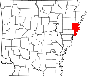
Crittenden County is a county located in the U.S. state of Arkansas. As of the 2020 census, the population was 48,163. The county seat is Marion, and the largest city is West Memphis.

<span class="mw-page-title-main">West Crossett, Arkansas</span> CDP in Arkansas, United States

West Crossett is a census-designated place (CDP) in Ashley County, Arkansas, United States. Per the 2020 census, the population was 1,144.

<span class="mw-page-title-main">Harrell, Arkansas</span> Town in Arkansas, United States

Harrell is a town in Calhoun County, Arkansas, United States. The population was 254 at the 2010 census. It is part of the Camden Micropolitan Statistical Area.

<span class="mw-page-title-main">Anthonyville, Arkansas</span> Town in Arkansas, United States

Anthonyville is a town in Crittenden County, Arkansas, United States. The population was 161 at the 2010 census, down from 250 in 2000.

<span class="mw-page-title-main">Crawfordsville, Arkansas</span> Town in Arkansas, United States

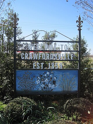
Crawfordsville, historically Crawfordville, is a town in Crittenden County, Arkansas, United States. The population was 479 at the 2010 census.

<span class="mw-page-title-main">Earle, Arkansas</span> City in Arkansas, United States

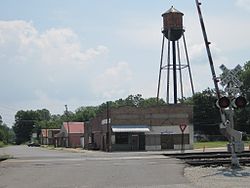
Earle is a city in Crittenden County, Arkansas, United States. Per the 2020 census, the population was 1,831.

<span class="mw-page-title-main">Edmondson, Arkansas</span> Town in Arkansas, United States

Edmondson is a town in Crittenden County, Arkansas, United States. The population was 427 at the 2010 census.

<span class="mw-page-title-main">Gilmore, Arkansas</span> City in Arkansas, United States

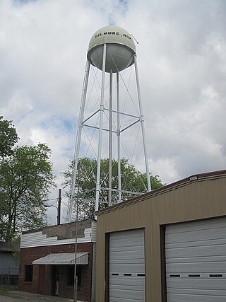
Gilmore is a city in Crittenden County, Arkansas, United States. Per the 2020 census, the population was 176.

<span class="mw-page-title-main">Horseshoe Lake, Arkansas</span> Town in Arkansas, United States

Horseshoe Lake is a town in Crittenden County, Arkansas, United States. The population was 264 at the 2020 census.

<span class="mw-page-title-main">Jennette, Arkansas</span> Town in Arkansas, United States

Jennette is a town in Crittenden and St. Francis counties, Arkansas, United States. The population was 118 at the 2020 census.

<span class="mw-page-title-main">Jericho, Arkansas</span> Town in Arkansas, United States

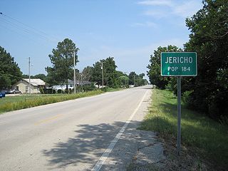
Jericho is a town in Crittenden County, Arkansas, United States. The population was 119 at the 2010 census, down from 184 in 2000.

<span class="mw-page-title-main">Sunset, Arkansas</span> Town in Arkansas, United States

Sunset is a town in Crittenden County, Arkansas, United States. The population was 198 at the 2010 census.

<span class="mw-page-title-main">Carthage, Arkansas</span> Town in Arkansas, United States

Carthage is a town in Dallas County, Arkansas, United States. The population was 343 at the 2010 census.

<span class="mw-page-title-main">Bradley, Arkansas</span> City in Arkansas, United States

Bradley is a city in Lafayette County, Arkansas, United States. The population was 628 at the 2010 census.

<span class="mw-page-title-main">Hoxie, Arkansas</span> City in Arkansas, United States

Hoxie is a city in Lawrence County, Arkansas, United States. It lies immediately south of Walnut Ridge. The population was 2,780 at the 2010 census.

<span class="mw-page-title-main">Bassett, Arkansas</span> Town in Arkansas, United States

Bassett is a town in Mississippi County, Arkansas, United States. The population was 124 at the 2020 census, down from 173 in 2010.

<span class="mw-page-title-main">Landmark, Arkansas</span> CDP in Arkansas, United States

Landmark is a census-designated place (CDP) in Pulaski County, Arkansas, United States. Per the 2020 census, the population was 3,585. It is part of the Little Rock–North Little Rock–Conway Metropolitan Statistical Area.

<span class="mw-page-title-main">Hardy, Arkansas</span> City in Sharp and Fulton counties, US

Hardy is the 2nd oldest city in Sharp and Fulton counties in the U.S. state of Arkansas. The population was 765 in 2020.

<span class="mw-page-title-main">Burlington, Kansas</span> City in Coffey County, Kansas, United States

Burlington is a city in and the county seat of Coffey County, Kansas, United States. As of the 2020 census, the population of the city was 2,634.

References

  1. "2020 U.S. Gazetteer Files". United States Census Bureau. Retrieved October 29, 2021.
  2. 1 2 U.S. Geological Survey Geographic Names Information System: Turrell, Arkansas
  3. "Turrell city, Arkansas". United States Census Bureau . Retrieved April 15, 2022.
  4. "Geographic Identifiers: 2010 Demographic Profile Data (G001): Turrell city, Arkansas". U.S. Census Bureau, American Factfinder. Archived from the original on February 12, 2020. Retrieved June 19, 2014.
  5. "Decennial Census of Population and Housing by Decades". US Census Bureau.
  6. 1 2 "P2 Hispanic or Latino, and Not Hispanic or Latino by Race – 2010: DEC Redistricting Data (PL 94-171) – Turrell city, Arkansas". United States Census Bureau .
  7. 1 2 "P2 Hispanic or Latino, and Not Hispanic or Latino by Race – 2020: DEC Redistricting Data (PL 94-171) – Turrell city, Arkansas". United States Census Bureau .
  8. "U.S. Census website". United States Census Bureau . Retrieved 2008-01-31.
  9. "2020 CENSUS - SCHOOL DISTRICT REFERENCE MAP: Crittenden County, AR" (PDF). U.S. Census Bureau . Retrieved 2022-09-22.
  10. "ConsolidationAnnex_from_1983.xls" (Archive). Arkansas Department of Education. Retrieved on October 13, 2017.
  11. Lesnick, Gavin (12 April 2010). "VIDEO: Turrell School District consolidated into Marion". Arkansas Democrat-Gazette . Retrieved 11 February 2013.