Twechar

Last updated

Twechar
Bar Hill from the air (geograph 4517293).jpg
Twechar and Bar Hill
East Dunbartonshire UK location map.svg
Red pog.svg
Twechar
Location within East Dunbartonshire
Population1,340 (mid-2020 est.) [1]
OS grid reference NS698754
Council area
Lieutenancy area
Country Scotland
Sovereign state United Kingdom
Post town GLASGOW
Postcode district G65
Dialling code 01236
Police Scotland
Fire Scottish
Ambulance Scottish
UK Parliament
Scottish Parliament
List of places
UK
Scotland
55°57′04″N4°05′06″W / 55.951°N 4.085°W / 55.951; -4.085 Coordinates: 55°57′04″N4°05′06″W / 55.951°N 4.085°W / 55.951; -4.085

Twechar is a small former mining village historically in Dunbartonshire and administered by the council area of East Dunbartonshire, Scotland close to the boundary with North Lanarkshire. [2] It lies between the larger towns of Cumbernauld, Kilsyth and Kirkintilloch. [3] The Forth and Clyde Canal runs close to the village to the north, and closely follows the line of the Antonine Wall. [4] There are visible remains of the wall on Bar Hill and the Roman Fort is a local tourist attraction. [5]

Contents

History

RIB 2180. Tablet of the Second Legion from Shirva, Twechar. Titulihunteriani00macdrich raw 0141a2.png
RIB 2180. Tablet of the Second Legion from Shirva, Twechar.

The etymology of the name is probably ‘causeway or pavement’. [7] Several old documents show Twechar with various spellings including maps by Charles Ross, [8] and William Roy. [9] There is a long history of mining activity in the Twechar locality but it was not until the coming of William Baird & Co. to the area, about 1860, that a close-knit mining community was created. [10] Before that time Shirva was described as having the best farm land in the parish. [11] Several tombstones from a possible Roman Cemetery were found at Shirva House. [12] A legionary slab was also discovered. In 2020 a replica of the Eastermains stone was installed in Twechar. It was found on near the discovery site of the 20th Legion's slab: on Eastermains Farm (which adjoins Whitehill), west of Inchbelly Bridge, east of Kirkintilloch and is often associated with Auchendavy. [13] It has been scanned and a video produced. [14] It is similar to two other distance slabs of the Sixth Legion. [15] [16]

Mining

Pits were sunk at Twechar and Gartshore and a row of workers' houses was built on the south bank of the Forth and Clyde canal, just east of Twechar Bridge.

The coal mining industry begun by the Bairds in the 1860s lasted for just over a century. Twechar No.1 Pit, on the north bank of the canal to the east of Twechar Bridge, closed in 1964, while Gartshore 9/11, the very last colliery in the area, was shut down in 1968. Thereafter some Twechar men travelled each day to collieries such as Bedlay and Cardowan in Lanarkshire, until they too were closed, during the early 1980s.

Baird & Co. provided rail connections to their local pits at an early date but for many years much of their coal was transported to market by canal boat. During the 1860s the canal company permitted Baird & Co. to place a railway swing bridge over the canal, a short distance to the west of Twechar road bridge, for the purpose of forming a connection between collieries on either side of the canal. As part of the deal the coal company agreed to transport a proportion of its coal by canal although this requirement lapsed early in the twentieth century. However, the swing bridge continued in use until the mid-1960s, its hand-winding apparatus having been made redundant on 1 January 1963, when the canal closed.

Housing

Old postcard of Barrhill Rows Twechar miner's housing.jpg
Old postcard of Barrhill Rows
Unsafe Twechar Swing Bridge prior to repair Twechar Bridge (geograph 1896813).jpg
Unsafe Twechar Swing Bridge prior to repair
Twechar from the air Twechar from the air (geograph 5308166).jpg
Twechar from the air

The original housing provided by William Baird & Co soon proved inadequate and around 1880 the Barrhill Rows were constructed at right angles to Main Street, on its western side. [20]

At first there were four rows, supplemented by two more about 1900, by which date the total number of dwellings in the rows was 160. The row nearest the canal included a Gartsherrie Co-operative shop and accordingly was known as the 'Store Row'.

Initially the houses had no sanitation and were lit by paraffin lamps. Communal wash houses were provided at intervals along each row. Most of the houses were of the two-apartment (room & kitchen) variety.

A great improvement was made in 1925, when Baird & Co. (in response to considerable pressure from the miners themselves, over the years) provided good quality modern housing for their mine workers at Burnbrae, Annieston, Sunnyhill and adjacent streets. There were 200 dwellings in all, some two-apartment and some three-apartment, built in two-story blocks of four. They were provided with bathrooms and electric lighting. When these houses were built the old row on the south bank of the canal was demolished. The Barrhill Rows, however, lasted until 1957. The Baird houses of 1925 are currently being demolished and little remains of Burnbrae, Whitelaw Terrace, Shirva lea and Merryflats ( Nov 09 ). Later housing was provided by Dunbartonshire County Council at MacDonald Crescent (1939), Alexander Avenue (1948) and Kelvin View (about 1955).

In the 2001 census, the population was recorded as 1,363, a drop of over 9% from the previous census in 1991. [21]

Schools

The village also had its own secondary education in Twechar School (now Twechar Primary School) until secondary schools in Cumbernauld and Kirkintilloch opened and secondary age pupils were sent by bus to these schools.

Pupils from Twechar Primary now go on to further education at the new state of the art Kirkintilloch High School. [22] The Roman Catholic children are taught in Kirkintilloch for their primary and at the new St Ninian's High School, Kirkintilloch for their secondary education. the primary school has an estimate of 70-90 pupils ( 2010 .

Transport

Twechar railway station on the Kelvin Valley Railway served the village and area from 1878 to 1951. It was named Gavell from 1878 until 1924.

Redevelopment

The war memorial on Twechar's Main Street. War memorial twechar.JPG
The war memorial on Twechar's Main Street.

The reopening of the Forth & Clyde Canal, in May 2001, brought with it great opportunities for the development of Twechar, which lies close to the canal's half-way point. [23]

Currently the village is undergoing a regeneration, EDC and private enterprise have put forward proposals to build approximately 200+ new houses, older housing stock in the "National Coal Board" scheme will be demolished from late 2007 onwards if the plan goes ahead.

Newer small business units have also been built in the small enterprise park opposite the war memorial, and an application for new housing has been raised with the council for new housing next to Kelvin View (November 2009). As of February 2012, residents have been moving into their new homes at the new Kelvin View housing site near the top end of Davison Crescent, the tenants seem very happy with their new homes.

Various new walkways have also been made, in and around the village and the glen.

The local leisure centre has undergone an expensive renovation and has been re-titled " The Twechar healthy living and enterprise centre." There is also a pharmacy run by M & D Green Dispensing Chemists Ltd. Negotiations to obtain a GP have been ongoing for some time.

An area to the rear of the former Masonic Hall (Lodge Barrhill Twechar 1444) has already been developed for boating purposes on the canal, a slipway and floating pontoon are already in-situ, hopefully there will be a community canal boat in place in the near future.

Churches

There is a Church of Scotland congregation, Twechar Parish Church, which shares a minister with Banton. The Roman Catholic villagers are served by St. John of the Cross Chapel in Twechar. There is also a Church of the Nazarene.

Roman Tombstones

Several Roman tombstones have been found at Shirva. [24] Several of them have been scanned and videos have been produced. They are sometimes connected with Auchendavy since Wester Shirva Farm is about halfway between there and Bar Hill. Archaeological excavations at Bar Hill have in turn revealed a formerly unknown early Roman 'marching' camp to the south of the Fort, and an artesian well in the Commandant's courtyard which has produced numerous finds, presumably hastily tossed in by the Romans as they abandoned the Fort and wall. Twechar has in fact 3 Roman camps – both aforementioned sites at Bar Hill and another in the farmer's field adjacent to St John of the Cross.

Titulihunteriani00macdrich raw 0139ShirvaRS37.png
RS 37. A sepulchral banquet. Video. [25]
Titulihunteriani00macdrich raw 0139ShirvaRS38b.png
RS 38. Another sepulchral banquet. Video. [26]
Titulihunteriani00macdrich raw 0149c.png
RIB 2181. [27] Tombstone for Flavius Lucianus. Video. [28]
Twechar Parish Church Twechar Parish Church (geograph 3036627).jpg
Twechar Parish Church
Shirva Pend Shirva Pend (geograph 2288210).jpg
Shirva Pend
Titulihunteriani00macdrich raw 0151 RIB2182.png
RIB 2182. [29] Tombstone for Salmanes Video. [30]
Titulihunteriani00macdrich raw 0151 RIB2183.png
RIB 2183. [31] Tombstone for Verecunda. Video. [32]
Titulihunteriani00macdrich raw 0149b2.png
Fragment of tombstone from Shirva, Twechar. Video. [33]
Titulihunteriani00macdrich raw 0145Shirva.png
Stone fragment possibly from Shirva, Twechar
Twechar tombstones. [34]

Related Research Articles

<span class="mw-page-title-main">East Dunbartonshire</span> Council area of Scotland

East Dunbartonshire is one of the 32 council areas of Scotland. It borders the north of Glasgow and contains many of the affluent areas to the north of the city, including Bearsden, Milngavie, Milton of Campsie, Balmore and Torrance, as well as many of the city's commuter towns and villages. East Dunbartonshire also shares borders with North Lanarkshire, Stirling and West Dunbartonshire. The council area covers parts of the historic counties of Dunbartonshire, Lanarkshire and Stirlingshire.

<span class="mw-page-title-main">Bishopbriggs</span> Town in Scotland

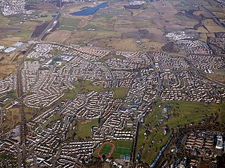
Bishopbriggs is a town in East Dunbartonshire, Scotland. It lies on the northern fringe of Greater Glasgow, approximately 4 miles (6 km) from the city centre. Historically in Lanarkshire, the area was once part of the historic parish of Cadder - originally lands granted by King William the Lion to the Bishop of Glasgow, Jocelin, in 1180. It was later part of the county of Lanarkshire, and then an independent burgh from 1964 to 1975. Today, Bishopbriggs' close geographic proximity to Glasgow now effectively makes it a suburb and commuter town of the city. The town's original Gaelic name Coille Dobhair reflects the name of the old parish of Cadder, but modern Gaelic usage uses Drochaid an Easbaig, a literal translation of Bishopbriggs. It was ranked the 2nd most desirable postcode in Scotland to live in following a study by the Centre for Economic and Business Research in 2015 and 2016.

<span class="mw-page-title-main">Legio VI Victrix</span> Roman legion

Legio VI Victrix was a legion of the Imperial Roman army founded in 41 BC by the general Octavian. It was the twin legion of VI Ferrata and perhaps held veterans of that legion, and some soldiers kept to the traditions of the Caesarian legion.

<span class="mw-page-title-main">Kilsyth</span> Human settlement in Scotland

Kilsyth is a town and civil parish in North Lanarkshire, roughly halfway between Glasgow and Stirling in Scotland. The estimated population is 10,380. The town is famous for the Battle of Kilsyth and the religious revivals of the 18th, 19th, and 20th centuries. The town now has links with Cumbernauld at one time being part of Cumbernauld and Kilsyth District Council. The towns also have the same members of parliament at Holyrood and Westminster.

<span class="mw-page-title-main">Summerston</span> Human settlement in Scotland

Summerston is a residential area of Glasgow, Scotland. With most of the housing constructed in the 1970s, it is situated in the far north of the city and is considered to be part of the larger Maryhill district, but has a different postcode; other nearby neighbourhoods are Gilshochill to the south and Cadder to the south-east. With open farmland to the north-east, Summerston is separated from the southern parts of the town of Bearsden to the north-west by the River Kelvin and a golf course.

<span class="mw-page-title-main">Duntocher</span> Human settlement in Scotland

Duntocher is a village in West Dunbartonshire, Scotland. It has an estimated population of 6,850. The etymology of the name of the village indicates that its name means "the fort on the causeway".

<span class="mw-page-title-main">River Kelvin</span> River in Scotland

The River Kelvin is a tributary of the River Clyde in northern and northeastern Glasgow, Scotland. It rises on the moor south east of the village of Banton, east of Kilsyth. At almost 22 miles (35 km) long, it initially flows south to Dullatur Bog where it falls into a man made trench and takes a ninety degree turn flowing west through Strathkelvin and along the northern boundary of the bog parallel with the Forth and Clyde Canal.

<span class="mw-page-title-main">Old Kilpatrick</span> Human settlement in Scotland

Old Kilpatrick, is a village in West Dunbartonshire, Scotland. It has an estimated population of 4,820. It belonged to the parish of Old Kilpatrick which itself was only a few thousand people strong.

<span class="mw-page-title-main">Cadder</span> Human settlement in Scotland

Cadder is a district of the town of Bishopbriggs, East Dunbartonshire, Scotland. It is located 7 km north of Glasgow city centre, 0.5 km south of the River Kelvin, and approximately 1.5 km north-east of Bishopbriggs town centre, sited on the route of the Forth and Clyde Canal. There is a Glasgow council housing scheme of a similar name, generally pronounced Cawder, in the district of Lambhill some 3 miles (5 km) to the south-west along the Canal, which was built in the early 1950s. Similarly, within Cadder, there is Cawder Golf Club, which also uses that original pronunciation.

<span class="mw-page-title-main">Torrance, East Dunbartonshire</span> Human settlement in Scotland

Torrance is a relatively affluent village in East Dunbartonshire, formerly Stirlingshire, Scotland, located eight miles north of Glasgow city centre. Torrance used to mainly consist of farmland. The village was once famous as a resting place for workers on their way to the Campsie Fells four miles north. The Forth and Clyde Canal has a wharf nearby at Hungryside, and the A807 runs along its southern edge. The village has an active community charity whose aims are to improve the village facilities.

<span class="mw-page-title-main">Castlecary</span> Human settlement in Scotland

Castlecary is a small historic village in North Lanarkshire, Scotland, directly adjacent to the border with Falkirk. It has long been associated with infrastructure, being adjacent to a bridged river, a Roman fort and roads, a nationwide canal, a Victorian railway viaduct, and a modern motorway. Castlecary is close to the town of Cumbernauld but like Dullatur and Luggiebank is not officially part of the town. Around 1725, the barony of Castlecary, with a population of just seventeen families, was disjoined from the parish of Falkirk, and annexed to Cumbernauld quoad sacra. Castlecary is also near Allandale which, though in the Falkirk council area, was built for Castlecary fireclay workers.

<span class="mw-page-title-main">Forth and Clyde Canal Pathway</span> Canal walkway

The Forth and Clyde canal pathway runs between the Firth of Forth and the Firth of Clyde and is a 106-kilometre-long (66 mi) footpath and cycleway that runs across Scotland, between Bowling, west of Glasgow, and Lochrin Basin in Edinburgh. The path runs on the towpaths of the Forth & Clyde and Union Canals and is entirely off road. The path is well maintained and its surface is generally good, although there are some stretches particularly between Falkirk and the outskirts of Edinburgh where wet weather leads to muddy conditions unsuitable for road intended bicycles. It is well used by walkers and cyclists, and designated as one of Scotland's Great Trails by NatureScot. It also forms part of the National Cycle Network, being designated as Route 754. Sustrans advises that the path is best followed from the Clyde to the Forth because the prevailing wind is from the south west. Much of the path is also suitable for experienced horseriders, although in some places low bridges, narrow aqueducts and gates may restrict access for horses.

<span class="mw-page-title-main">Stewart MacDonald</span>

Stewart MacDonald is a Scottish Labour Party local government councillor. He was elected to the East Kirkintilloch and Twechar Ward of East Dunbartonshire Council in the 2007 election. He is also a member of Kirkintilloch Community Council and the Bridgeton Burns Club, and was a director of the East Dunbartonshire Municipal Bank between 2007 and 2015 and the East Dunbartonshire Leisure and Culture Trust from 2010 to the present.

The Kelvin Valley Railway was an independent railway designed to connect Kilsyth, an important mining town in central Scotland, with the railway network. It connected Kilsyth to Kirkintilloch and thence over other railways to the ironworks of Coatbridge, and to Maryhill, connecting onwards to the Queen's Dock at Stobcross.

<span class="mw-page-title-main">Donald's Quay</span> Human settlement in Scotland

Donald's Quay was once the location of the northern terminus of the Erskine Ferry then run by Lord Blantyre of Erskine House that provided foot passengers with a crossing of the River Clyde, giving direct access between Dunbartonshire and Renfrewshire. At some point in the early 19th century the northern terminus of the Erskine Ferry moved to a site closer to Old Kilpatrick and opposite the Ferry House at Erskine, before closure in 1971 when the Erskine Bridge was completed. Donald's Quay once had an approximately 170-foot-long (52-metre) stone pier that was used by coal boats that transferred their loads into canal barges on the Forth & Clyde Canal at Ferrydyke Wharf and thereby avoided paying fees at the Bowling Basin. The quay was demolished during the construction of the Lanarkshire and Dumbartonshire Railway in 1896.

<span class="mw-page-title-main">Bar Hill Fort</span>

Bar Hill Fort was a Roman fort on the Antonine Wall in Scotland. It was built around the year 142 A.D.. Older maps and documents sometimes spell the name as Barr Hill. A computer generated fly around for the site has been produced. Lidar scans have been done along the length of the wall including Bar Hill. Sir George Macdonald wrote about the excavation of the site. Many other artefacts have also been found at Shirva, about a mile away on the other side of Twechar.

<span class="mw-page-title-main">Auchendavy</span>

Auchendavy was a Roman fort on the Antonine Wall in Scotland. Much of the site archeology was destroyed by the builders of the Forth and Clyde Canal. Between Bar Hill and Balmuildy the wall roughly follows the southern bank of the River Kelvin. The site of the fort is north of Kirkintilloch's northern border. It can be seen as a mound mid-way between the Forth and Clyde Canal and the road.

<span class="mw-page-title-main">Glasgow Bridge, Kirkintilloch</span>

Glasgow Bridge is the site of a road bridge over the Forth and Clyde Canal; it is also the site of a Roman fortlet, on the Antonine Wall, halfway between the Roman forts at Kirkintilloch and Cadder.

<span class="mw-page-title-main">Balmuildy</span>

Balmuildy is the site of a Roman fort on the Antonine Wall in Scotland. It is one of only two forts on the Antonine Wall to have been found with stone ramparts; the other is Castlecary. A digital reconstruction of the fort has been created.

<span class="mw-page-title-main">Kirkintilloch East and North and Twechar (ward)</span> Local government ward of East Dunbartonshire

Kirkintilloch East and North and Twechar is one of the seven wards used to elect members of the East Dunbartonshire Council. It elects three Councillors. The current entity was technically created in 2017 following a boundary review, but has largely the same boundaries as the 2007 Kirkintilloch East and Twechar ward, which as its name suggests encompassed the eastern parts of Kirkintilloch and the separate village of Twechar further east, up to the boundary with Kilsyth and Cumbernauld in North Lanarkshire.

References

  1. "Mid-2020 Population Estimates for Settlements and Localities in Scotland". National Records of Scotland. 31 March 2022. Retrieved 31 March 2022.
  2. Morrison, Sue (2017). Twechar An Oral History of a Pit Village (PDF). Twechar: Oral History Research & Training Consultancy. Retrieved 16 February 2018.
  3. Forman, Adam (1845). The new statistical account of Scotland (Vol 8 ed.). Edinburgh and London: W. Blackwood and Sons. pp. 168–211. Retrieved 11 February 2018.
  4. "OS 25 inch 1892-1949". National Library of Scotland. Ordnance Survey. Retrieved 26 October 2017.
  5. Beers, Roy (14 January 2018). "New app takes a time travel trip to area's Roman past". The Falkirk Herald. Retrieved 11 February 2018.
  6. "RIB 2180. Building Inscription of the Second Legion". Roman Inscriptions of Britain. Retrieved 2 June 2018.
  7. Drummond, Peter, John (2014). An analysis of toponyms and toponymic patterns in eight parishes of the upper Kelvin basin (PDF). Glasgow: Glasgow University. p. 314. Retrieved 3 July 2017.
  8. "Ross' map with Twechar over the Kelven Water". NLS. Retrieved 27 January 2018.
  9. "Roy's map of the Lowlands". NLS. Retrieved 27 January 2018.
  10. Watson, Thomas (1894). Kirkintilloch, town and parish. Glasgow: J. Smith. p. 138. Retrieved 13 October 2017.
  11. Forman, Adam (1845). The new statistical account of Scotland (Vol 8 ed.). Edinburgh and London: W. Blackwood and Sons. p. 197. Retrieved 11 February 2018.
  12. "Shirva". Canmore. Historic Environment Scotland. Retrieved 2 June 2018.
  13. "OS 25 inch map 1892-1949, with Bing opacity slider". National Library of Scotland. Ordnance Survey. Retrieved 12 October 2017.
  14. "Distance Slab of the Sixth Legion, Eastermains" . Retrieved 14 November 2017.
  15. Sabljak, Ema (26 December 2020). "Rediscovering the Antonine Wall £2.1m project makes mark". Glasgow Evening Times.
  16. Mitchell, Jenness (28 December 2020). "Roman replica takes pride of place near Antonine Wall site". STV news.
  17. McVail, John C. (1911). Housing of Scottish miners : report on the housing of miners in Stirlingshire and Dunbartonshire. Glasgow: Robert MacLehose. p. 14. Retrieved 11 February 2018.
  18. Dalton, Alastair (1 February 2018). "'Unsafe' bridges force indefinite Forth & Clyde Canal closure". The Scotsman. Retrieved 11 February 2018.
  19. "Bridge restrictions & operational changes". Scottish Canals. Scottish Canals. Retrieved 17 January 2019.
  20. McVail, John C. (1911). Housing of Scottish miners : report on the housing of miners in Stirlingshire and Dunbartonshire. Glasgow: Robert MacLehose. pp. 33–34. Retrieved 11 February 2018.
  21. "Key Statistics for Settlements and Localities Scotland" (PDF). 2001 Census. General Register Office for Scotland. 25 March 2003. Archived from the original (PDF) on 25 November 2010. Retrieved 8 March 2013.
  22. "Kirkintilloch High School - Home". Kirkintilloch.e-dunbarton.sch.uk. Retrieved 13 April 2012.
  23. Sutton, Sandra. "Short Film Clips – Oral Testimony". twecharpitvillage. Retrieved 16 February 2018.
  24. "OS 25 inch 1892-1949". National Library of Scotland. Ordnance Survey. Retrieved 26 October 2017.
  25. "Fragment of a tombstone, Twechar" . Retrieved 2 June 2018.
  26. "Fragment of tombstone, Shirva, Twechar" . Retrieved 2 June 2018.
  27. "RIB 2181. Funerary inscription for Flavius Lucianus". Roman Inscriptions of Britain. Retrieved 26 May 2018.
  28. "Graveslab of Flavius Lucianus, Shirva, Twechar" . Retrieved 2 June 2018.
  29. "RIB 2182. Funerary inscription for Salmanes". Roman Inscriptions of Britain. Retrieved 26 May 2018.
  30. "Graveslab of Salmanes, Shirva, Twechar" . Retrieved 2 June 2018.
  31. "RIB 2183. Funerary inscription for Verecunda". Roman Inscriptions of Britain. Retrieved 26 May 2018.
  32. "Grave Stone of Verecunda" . Retrieved 2 June 2018.
  33. "Fragment of a tombstone, Shirva, Twechar" . Retrieved 2 June 2018.
  34. Macdonald, Sir George (1934). The Roman wall in Scotland, by Sir George Macdonald (2d ed., rev., enl., and in great part rewritten ed.). Oxford: The Clarendon press. p. 447. Retrieved 11 October 2017.