
James IV was King of Scotland from 11 June 1488 until his death at the Battle of Flodden in 1513. He inherited the throne at the age of fifteen on the death of his father, James III, at the Battle of Sauchieburn, following a rebellion in which the younger James was the figurehead of the rebels. James IV is generally regarded as the most successful of the Stewart monarchs. He was responsible for a major expansion of the Scottish royal navy, which included the founding of two royal dockyards and the acquisition or construction of 38 ships, including the Michael, the largest warship of its time.

The Battle of Flodden, Flodden Field, or occasionally Branxton or Brainston Moor was a battle that was fought on 9 September 1513 during the War of the League of Cambrai between the Kingdom of England and the Kingdom of Scotland and resulted in an English victory. The battle was fought near Branxton, in the county of Northumberland, in northern England, between an invading Scots army under King James IV and an English army commanded by the Earl of Surrey. In terms of troop numbers, it was the largest battle ever fought between the two kingdoms.
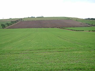
Branxton is a village and civil parish in northern Northumberland, England. It lies about 3 miles (5 km) from the England-Scotland border and about 4 miles (6 km) from the Scottish border town of Coldstream, just off the A697 Newcastle-Edinburgh road. At the 2011 Census, the population of the parish was 123, increasing slightly from 121 at the 2001 Census.
Norhamshire was an exclave of County Durham in England. It was first mentioned in 995, when it formed part of the lands of the priory at Lindisfarne. When the lands north of the River Tees were partitioned into Northumberland and County Durham it, along with Bedlingtonshire and Islandshire, stayed under the jurisdiction of Durham despite being north of the River Tyne.

Norham is a village and civil parish in Northumberland, England, It is located 7 miles (11 km) south-west of Berwick on the south side of the River Tweed where it is the border with Scotland.
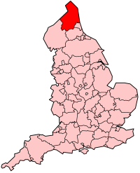
Northumberland, England's northernmost county, is a land where Roman occupiers once guarded a walled frontier, Anglian invaders fought with Celtic natives, and Norman lords built castles to suppress rebellion and defend a contested border with Scotland. The present-day county is a vestige of an independent kingdom that once stretched from Edinburgh to the Humber, hence its name, meaning literally 'north of the Humber'. Reflecting its tumultuous past, Northumberland has more castles than any other county in England, and the greatest number of recognised battle sites. Once an economically important region that supplied much of the coal that powered the industrial revolution, Northumberland is now a primarily rural county with a small and gradually shrinking population.

The River Till is a river of north-eastern Northumberland. It is a tributary of the River Tweed, of which it is the only major tributary to flow wholly in England. Upstream of the locality of Bewick Bridge, 8.5 km to the southeast of Wooler the river is known as the River Breamish. It rises on Comb Fell in the Cheviot Hills.

Tweedmouth is part of the town of Berwick-upon-Tweed in Northumberland, England. It is located on the south bank of the River Tweed and is connected to Berwick town centre, on the north bank, by two road bridges and a railway bridge. Tweedmouth has historically always been part of England, in contrast to the walled town of Berwick which came under Scottish control for several periods in the Middle Ages. The local nickname for people from Tweedmouth is "Twempies". In 1951 the parish had a population of 6410.

The Ladykirk and Norham Bridge connects Ladykirk in the Borders, Scotland, with Norham in Northumberland, England, across the River Tweed. It's one of three bridges that cross it along the Anglo-Scottish Border, the others being the Coldstream Bridge and the Union Chain Bridge; out of these, the Ladykirk and Norham Bridge is the youngest, opening to the public in 1888.

Coldstream Bridge, linking Coldstream, Scottish Borders with Cornhill-on-Tweed, Northumberland, is an 18th-century Category A/Grade II* listed bridge between England and Scotland, across the River Tweed. The bridge carries the A697 road across the Tweed.

The Royal Border Bridge spans the River Tweed between Berwick-upon-Tweed and Tweedmouth in Northumberland, England. It is a Grade I listed railway viaduct built between 1847 and 1850, when it was opened by Queen Victoria. It was designed by Robert Stephenson. It was built for the York, Newcastle and Berwick Railway and is still in regular use today, as part of the East Coast Main Line. Despite its name, the bridge does not in fact span the border between England and Scotland, which is approximately three miles further north.

The Royal Tweed Bridge is a road bridge in Berwick-upon-Tweed, Northumberland, England crossing the River Tweed. It was intended to divert traffic from the 17th century Berwick Bridge, and until the 1980s it formed part of the A1 road, the main route from London to Edinburgh. However, the construction of the A1 River Tweed Bridge to the west of Berwick has since reduced the Royal Tweed Bridge's importance.

Ford is a small village and civil parish in Northumberland, England, about 13 miles (21 km) from Berwick-upon-Tweed. The parish also includes Etal.
This timeline summarises significant events in the history of Northumbria and Northumberland.

The Anglo-Scottish Wars comprise the various battles which continued to be fought between the Kingdom of England and the Kingdom of Scotland from the time of the Wars of Independence in the early 14th century through to the latter years of the 16th century.

Twizell Castle is a Grade II* listed building and a Scheduled Ancient Monument which stands on a bend of the River Till at Tillmouth Park, Northumberland, northern England. Below it, the medieval Twizell Bridge spans the river. It is located 10 miles (16 km) south-west of Berwick Upon Tweed. The site is visible from a public footpath, which passes the castle from the road. The gardens of the castle contain the earthwork remains of the once lost medieval village of Twizell, whilst the massive ruin presents the remains of an 18th-century castle which was never completed.
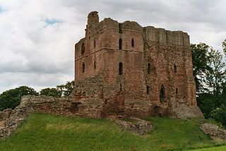
Norham Castle is a castle in Northumberland, England, overlooking the River Tweed, on the border between England and Scotland. It is a Grade I listed building and a Scheduled Ancient Monument. The castle saw much action during the wars between England and Scotland.

The Anglo-Scottish border is a border separating Scotland and England which runs for 96 miles (154 km) between Marshall Meadows Bay on the east coast and the Solway Firth in the west.
Ladykirk is a village on the B6470 in the Scottish Borders area of Scotland, and the former Berwickshire, just north of the River Tweed and the Anglo-Scottish border. The town was formerly known as Upsettlington, but King James IV of Scotland renamed the town Ladykirk; the church is also known as St Mary's Church or Kirk of Steill. Ladykirk stands directly opposite Norham Castle, Northumberland, England
Scottish invasions of England occurred several times over a period of centuries. This is a list of notable invasions.

