Ulnaby

Last updated

Ulnaby
Ulnaby Hall Farm - geograph.org.uk - 75415.jpg
Ulnaby Hall Farm, site of lost village
Durham UK location map.svg
Red pog.svg
Ulnaby
Location within County Durham
Area0.16 km2 (0.062 sq mi)
Population0 
  Density 0/km2 (0/sq mi)
OS grid reference NZ226172
Unitary authority
Ceremonial county
Region
Country England
Sovereign state United Kingdom
Post town DARLINGTON
Postcode district DL2
Dialling code 01325
Police Durham
Fire County Durham and Darlington
Ambulance North East
UK Parliament
List of places
UK
England
County Durham
54°33′14″N1°38′59″W / 54.553966°N 1.649818°W / 54.553966; -1.649818

Ulnaby is an abandoned village and scheduled ancient monument in the grounds of Ulnaby Hall Farm, near High Coniscliffe, County Durham, England. The toft village was occupied from the late-13th to the 16th century and temporary buildings were erected in the 19th century. Ulnaby Hall farm appears to have been built in the late-16th century, supplanting a high status medieval manorial enclosure associated with the original village. It is thought that the village shrank because of the change from labour-intensive arable farming to pasture, [1] before being abandoned and the site was subsumed into the farm as pasture. [2]

Contents

Location

The site is 6.8 km north-west of Darlington, in the grounds of Ulnaby Hall Farm, between Ulnaby Lane and the B6279, near High Coniscliffe, County Durham. The earthworks cover an area of 0.16 km2 under pasture, with the actual village covering 6.6 hectares. There are ridge and furrow areas to the north and west. There is visible evidence of two east–west rows of tofts either side of an east–west hollow way, and on the north side of the hollow way is the village green. The site, which slopes gently to the south, is bounded by roads on the north and west sides, and a stream to the south. Beneath the pasture the archaeology is on boulder clay overlying the Magnesian Limestone. Three fields make up the site: an 1841 document says that the western field was called Back Field, the eastern field was Garths and the southern field was New Acridge Carr. The fields immediately to the west of the site were called Kiln Field and Lime Kiln Field, and there is evidence of quarrying in Back Field. A garth in this context is an enclosed garden, yard or paddock, and would refer to the existing earthworks. Carr refers to marshland in the context of old pasture. [2]

History

Context

The name, "Ulnaby", is possibly derived from the Old Norse for Ulfhethin's farm, which could imply that there was a pre-medieval settlement locally. Although archaeologists have not found reason to date the village itself before medieval times, there is local evidence of worked flints, a Bronze Age awl, three late Neolithic or early Bronze Age bowl barrows and the Roman road Dere Street, all within 3 kilometres. Roman items have been found locally at High Carlbury, High Coniscliffe and Ulnaby farm itself. [2]

Village and manor occupation

Ulnaby Hall farm Ulnaby Hall - geograph.org.uk - 137045.jpg
Ulnaby Hall farm

The village itself is believed to have been occupied from the late 13th to the 16th century; at first a few small tofts on the same hollow way which still leads east–west through the lost village. In the mid-12th century the land belonged to the Greystoke family, and by the late 13th century it was the property of William de Somerville, who exchanged it for Scottish land held by the Marmadukes. In 1320 a Marmaduke widow gave the land to Sir Thomas, Earl of Lancaster, and after Sir Thomas was executed in 1322 it reverted to the Neville family, at a time when the Carlbury and Ulnaby estates were jointly worth £20 per annum: quite profitable at that time. Before he died, it is thought possible that Lancaster redesigned the village around the green, and that he built the manor house in 1320 for a steward at the position now occupied by the southernmost farm buildings. The steward would have collected the peasants' dues for the absent landlord. [3] Ulnaby and its associated manor belonged to the House of Neville from 1343 to 1573, and it is also possible that the original manor on the site, where Ulnaby Hall now stands, was built by Sir Ralph de Neville around 1354. [2] Charles Neville forfeited it in 1571 for his part in the Rising of the North. Queen Elizabeth I granted it to the Tailboys family of Thornton Hall on 20 June 1573. [4]

The last medieval building survived on this spot until the 19th century, used as barn Ulnaby 011.jpg
The last medieval building survived on this spot until the 19th century, used as barn

Documents of 1629 and 1654 indicate that the estate consisted of the manor, four tofts, three cottages, five barns, three gardens and orchards, a water cornmill and dovecote, with 100 acres (0.40 km2) each of arable and meadow, 200 acres (0.81 km2) of pasture and 5 acres (20,000 m2) of woodland. [2] It has been suggested that around 1573 the Tailboys family replaced the original manor with Ulnaby Hall and farm, possibly re-using material from the old manor house. The village dwindled in size until it became part of the farm; by 1629, three – not four – tofts remained, according to one source. [3] [4] Ulnaby Hall has been thought to date from 1609: [5] this is possible as the earliest part of the hall dates from late 16th to early 17th century. [2] [6] Old maps show that Ulnaby village contained one last building of presumed medieval origin in 1855 beside the north-east corner of the present farm buildings, but that this was gone by 1896; it is said that it was used as a barn until the 1870s. [3] Some farm cottages were then added, and these still exist. It is thought that the reduction in size of the village was in response to the success of the cloth industry, which encouraged change from labour-intensive arable land to pasture. [4]

Archaeological surveys and excavations

English Heritage and NDVA Group

These earthworks were garths or toft enclosures Ulnaby 012.jpg
These earthworks were garths or toft enclosures

A non-intrusive earthwork survey was done by English Heritage's Archaeological Survey and Investigation team in 2007. [4] This suggested that there had been a village there without a green, then a toft village consisting of two rows of small farmsteads around a green. After that, some tofts were added and some abandoned. Next to the village there was an enclosed area including a manor, fishpond, dovecote and orchard. [4] At the same time as the English Heritage survey, the Northumberland and Durham Vernacular Architecture Group undertook a measured survey of Ulnaby Hall. They thought that a raised rectangular earthwork in the old village green could possibly have been the earliest evidence of village habitation, perhaps indicating an earlier manor or even a Roman building. They found possible lynchets on the north side of the old road as the hollow way enters the village from the east. [2]

View north to Walworth Castle Hotel, showing Ulnaby's ridge and furrow fields in foreground Ulnaby 019.jpg
View north to Walworth Castle Hotel, showing Ulnaby's ridge and furrow fields in foreground

The manorial enclosure was at least 1.6 hectares, and is considered to have been fairly high status. It was bounded by a wall of dressed limestone blocks, and contained a fishpond and dovecote. The fishpond was cut into an old ridge and furrow field, and the residence itself is believed to be underneath the present Ulnaby Hall. There is evidence of a succession of buildings on the site, terminating in the 19th century, but the village had shrunk by the 17th century, indicating the effect of the change from labour-intensive arable land to pasture. A survey of Ulnaby Hall shows a single-phase build in the late 16th century of a south-facing building of one large room over another and two wings at the back, with service rooms to the west. Two of the original gardens, to the south and east of the hall, still exist, and the third was probably the garth field or paddock to the south of the farm track. There was a smithy, five barns and orchards. [2] One of the peasant houses was quite large, having three rooms. [3] It is thought that the southern end of the site, around the water channel, was a marshy area that provided the village with various resources, and that it was drained in the 18th century. [3]

Time Team and Wessex Archaeology

In April 2008, archaeological television programme Time Team excavated the site. [7] A total of eight trenches were dug, and the report was written by Wessex Archaeology. Evidence was found of occupation from the late 13th or early 14th centuries until some time in the 15th century, when activity appears to have centred on the western tofts of the north row, and one or two tofts in the south row, until the 16th century. The double row of tofts with village green appeared to be the original pattern, and there was no evidence of pre-medieval occupation. The hollow way was cobbled and continued in regular use until the 19th century. Earlier buildings were found to be cruck-built with stone bases to the walls, and later ones probably stone-built. The manorial enclosure, early earthwork on the village green and the hollow way were not excavated. [2]

Preservation

The site is now listed as scheduled ancient monument, English Heritage Archive number 20961. [2] Ulnaby Hall survives as a Grade II listed building with its farm. Some of its blocked-up windows are said to date back to the 16th or 17th century. [3] An ancient sycamore tree and terrace in a field in front of the hall are survivors from one of the original gardens. [3] Ulnaby Hall is surrounded by fields of earthworks under pasture, showing banks, ditches, walls and hollow ways. Possibly one of the fishponds was at the south end of the site, fed by the water channel. It is thought that it is the use of land as pasture which has preserved the site unchanged since the village was deserted. [4] Around 2008, Ulnaby Hall Farm opened the site and farm as a visitor attraction. [8] A reconstruction painting of the medieval village has been produced for visitors, along with a self-guided walk leaflet. [3] Stiles, gates and bridges have been constructed for the use of visitors and to protect the earthworks, and guided walks were offered to local people by English Heritage. Wildlife at the site includes hares and owls. [5]

Ulnaby site looking east: hollow way once led from Ulnaby to Thornton Hall Ulnaby 010.jpg
Ulnaby site looking east: hollow way once led from Ulnaby to Thornton Hall

See also

Related Research Articles

<span class="mw-page-title-main">Open-field system</span> Prevalent ownership and land use structure in medieval agriculture

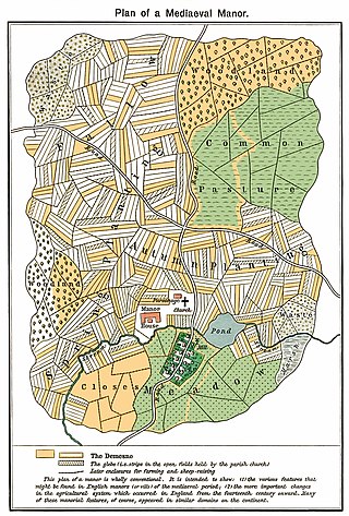
The open-field system was the prevalent agricultural system in much of Europe during the Middle Ages and lasted into the 20th century in Russia, Iran, and Turkey. Each manor or village had two or three large fields, usually several hundred acres each, which were divided into many narrow strips of land. The strips or selions were cultivated by peasants, often called tenants or serfs. The holdings of a manor also included woodland and pasture areas for common usage and fields belonging to the lord of the manor and the religious authorities, usually Roman Catholics in medieval Western Europe. The farmers customarily lived in separate houses in a nucleated village with a much larger manor house and church nearby. The open-field system necessitated co-operation among the residents of the manor.

<span class="mw-page-title-main">Quarrendon</span> Human settlement in England

Quarrendon or Quarrendon Leas is a medieval English village near Aylesbury in Buckinghamshire, England, which has been depopulated since the 16th century and is now a scheduled monument.

<span class="mw-page-title-main">Archdeacon Newton</span> Human settlement in England

Archdeacon Newton is a hamlet and rural parish of several farms in the borough of Darlington and the ceremonial county of County Durham, in England. The population taken at the 2011 Census was less than 100. Details are maintained in the parish of Walworth. It is associated with an abandoned village site under pasture and farm buildings, and situated a short distance to the north-west of Darlington. The lost settlement was in existence by the early 15th century, and remained inhabited at least until the 1890s. There was a moated manor house at the southern end, part of which remains as the Old Hall, now a barn. At the north end of the site was the chapel, and in the middle were tofts and enclosures, with a ridge and furrow field and a trackway leading to the south-east. The site of the abandoned village is now a scheduled monument and the Old Hall is a listed building.

<span class="mw-page-title-main">Carlbury</span> Village in County Durham, England

Carlbury is a hamlet in the civil parish of High Coniscliffe in County Durham, in England. It is situated a few miles to the west of Darlington, on the north bank of the River Tees between Piercebridge to the west, and High Coniscliffe to the east. High and Low Carlbury once constituted a slightly larger settlement, but most of the hamlet at Low Carlbury became derelict and was demolished by the late 1940s. A few buildings remain.

<span class="mw-page-title-main">Piercebridge</span> Human settlement in England

Piercebridge is a village and civil parish in the borough of Darlington and the ceremonial county of Durham, England. The population of the civil parish as of the 2011 census was 113. It is situated a few miles west of the town of Darlington. It is on the site of a Roman fort of AD 260–270, which was built at the point where Dere Street crossed the River Tees. Part of the fort is under the village green. The village is sited where the York-Newstead Roman road known as Dere Street crosses the River Tees.

<span class="mw-page-title-main">High Coniscliffe</span> Human settlement in England

High Coniscliffe is a parish and village in the borough of Darlington and ceremonial county of County Durham, England. The parish includes Carlbury and Low Coniscliffe. It is part of Heighington and Coniscliffe ward, and is situated approximately 4 miles (6.4 km) west of Darlington. At the 2011 Census the population of this civil parish was 242.

<span class="mw-page-title-main">Low Coniscliffe</span> Human settlement in England

Low Coniscliffe is a village in the civil parish of Low Coniscliffe and Merrybent, in County Durham, England. The population of the civil parish taken at the 2011 Census was 716. It is situated 3 miles (4.8 km) west of Darlington. Its present built-up area is confined in practice between the A1, the A67 and the Tees, but its old boundaries probably extend much further. Its most obvious landmark on the A67 is the Baydale Beck Inn. The village contains a couple of listed buildings and the probable site of a medieval manor house. There was once a gallows in the village. A rare fungus Rhodotus palmatus was found nearby.

<span class="mw-page-title-main">Sulgrave</span> Human settlement in England

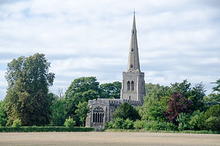
Sulgrave is a village and civil parish in West Northamptonshire, England, about 5 miles (8 km) north of Brackley. The village is just south of a stream that rises in the parish and flows east to join the River Tove, a tributary of the Great Ouse.

<span class="mw-page-title-main">Walworth, County Durham</span> Human settlement in England

Walworth is a central small village with outlying farmsteads, which together constitute a scattered village in the borough of Darlington and the ceremonial county of County Durham, England. It is a civil parish which does not have a church. The population of this civil parish at the 2011 Census was 240. It is situated 2.5 miles (4.0 km) to the north-west of Darlington. The nucleus of the central village is the 16th-century Walworth Castle, which is now a hotel. On the north side of the village, around North Farm, are earthworks signifying a lost settlement, grouped around a barn which was once a chapel.

<span class="mw-page-title-main">Docking, Norfolk</span> Human settlement in England

Docking is a village and ancient civil parish in the north-west of the English county of Norfolk. It is near the North Norfolk Coast Site of Special Scientific Interest.

<span class="mw-page-title-main">Knaptoft</span> Human settlement in England

Knaptoft is a deserted medieval village and civil parish in the Harborough district of Leicestershire and lies approximately 9.7 miles (15.6 km) south of the city of Leicester, England. According to the University of Nottingham English Place-names project, the settlement name Knaptoft could mean "cnafa" for 'a boy, a young man, a servant, a menial, or a personal name' and 'toft', the plot of ground in which a dwelling stands. The population of the civil parish at the 2011 census was 47.

<span class="mw-page-title-main">Appleby Magna</span> Human settlement in England

Appleby Magna is a village and civil parish in the North West Leicestershire district, in the county of Leicestershire, England. It includes the small hamlets of Appleby Parva and Little Wigston.

<span class="mw-page-title-main">Thornton-le-Street</span> Village and civil parish in North Yorkshire, England

Thornton-le-Street is a village and parochial and civil parish in the Hambleton District of North Yorkshire, England. It is part of the civil parish of Thornton-le-Moor and Thornton-le-Street for District purposes. As the population remained less 100 at the 2011 Census details are included in the civil parish of Thornton-le-Moor. In 2015, North Yorkshire County Council estimated the population to have been 90.

<span class="mw-page-title-main">Cliffe, Richmondshire</span> Village and civil parish in North Yorkshire, England

Cliffe is a small village and civil parish in Richmondshire district of North Yorkshire, England. A stream called the Glen runs through the village to the Tees. It is in the Teesdale and Yorkshire Dales national park. It is about 6 miles (10 km) west of Darlington, 10 miles (16 km) north of Richmond and near Piercebridge.

<span class="mw-page-title-main">Colmworth</span> Village and civil parish in England

Colmworth is a village and civil parish in the Borough of Bedford in the county of Bedfordshire, England about 6.5 miles (10 km) north-east of Bedford.

<span class="mw-page-title-main">Stainsby, North Yorkshire</span> Former village in Yorkshire, England

Stainsby, in North Yorkshire, England, is an abandoned village near the Acklam suburb of Middlesbrough and town of Thornaby. Little more than mounds near the A19 road are now visible. The site is a scheduled monument.

<span class="mw-page-title-main">Walworth Castle</span> Manor house in County Durham, England

Walworth Castle is an 11th-century castle, situated at Walworth, near Darlington, County Durham, England. It is a Grade 1 listed building. It was completed around 1600, probably by Thomas Holt for Thomas Jenison. It stands on the site of a former manor house or castle built in the 12th century by the Hansard family. The estate passed through the hands of the Ayscoughs and Aylmers besides the Hansards and Jenisons, and became a prisoner-of-war camp during World War II and then a girls' boarding school after the war. It has been a hotel since 1981.

<span class="mw-page-title-main">Legsby</span> Small village and civil parish in the West Lindsey district of Lincolnshire, England

Legsby is a small village and civil parish in the West Lindsey district of Lincolnshire, England. The population of the civil parish at the 2011 census was 193. It is situated approximately 13 miles (20 km) north-east from the city and county town of Lincoln and 3 miles (5 km) south-east from the town of Market Rasen.

<span class="mw-page-title-main">Thornton Hall, High Coniscliffe</span>

Thornton Hall is a privately owned 16th century manor house at High Coniscliffe, near Darlington, County Durham. It is a Grade I listed building.

References

  1. "Wessex Archaeology". Ulnaby Hall, High Coniscliffe. 27 April 2009. p. 6. Retrieved 17 March 2010.
  2. 1 2 3 4 5 6 7 8 9 10 Hall, Naomi (November 2008). "Wessex Archaeology". Ulnaby Hall, High Coniscliffe. Retrieved 17 March 2010.
  3. 1 2 3 4 5 6 7 8 Ulnaby Deserted Medieval Village: a self guided walk (leaflet). English Heritage. 2008. p. 6.
  4. 1 2 3 4 5 6 "English Heritage". Ulnaby medieval village. Retrieved 17 March 2010.
  5. 1 2 "Helm". Ulnaby. English Heritage. 2008. Retrieved 17 March 2010.
  6. "NTRDL". Ulnaby Hall. Nottingham Tree Ring Dating Laboratory. 8 October 2007. Retrieved 17 March 2010.
  7. "Time Team archaeologists dig deep to find ancient village". The Northern Echo. 19 April 2008. Retrieved 17 March 2010.
  8. "Visit Darlington". Medieval Ulnaby. Darlington Borough Council. 2008–2009. Retrieved 17 March 2010.

Visiting

Maps and photos

Time Team videos

Ulnaby in context of other historical sites