Umlazi

Last updated

Umlazi
Umlazi, South Africa.jpg
Umlazi
South Africa KwaZulu-Natal location map.svg
Red pog.svg
Umlazi
South Africa adm location map.svg
Red pog.svg
Umlazi
Africa location map.svg
Red pog.svg
Umlazi
Coordinates: 29°58′S30°53′E / 29.967°S 30.883°E / -29.967; 30.883
Country South Africa
Province KwaZulu-Natal
Municipality eThekwini
Area
[1]
  Total47.46 km2 (18.32 sq mi)
Population
 (2011) [1]
  Total404,811
  Density8,500/km2 (22,000/sq mi)
Racial makeup (2011)
[1]
   Black African 99.4%
   Coloured 0.1%
   Indian/Asian 0.2%
   White 0.1%
  Other0.1%
First languages (2011)
[1]
   Zulu 91.4%
   Xhosa 3.0%
   English 2.3%
   S. Ndebele 1.2%
  Other2.3%
Time zone UTC+2 (SAST)
Postal code (street)
4066
PO box
4031
Website http://umlazi.co.za/

Umlazi is a township in KwaZulu-Natal, South Africa, located south-west of Durban. Organisationally and administratively it forms part of the eThekwini Metropolitan Municipality and its South Municipal Planning Region.

Contents

It is the fourth largest township in South Africa, after Soweto, Tembisa and Katlehong. [2] Umlazi is the only township in the country that has its own registration plate, which is NUZ. It is divided into 26 sections, A through to Z, with the exception of I, O and X, but with an addition of AA, BB and CC.

Etymology

According to legend, the name Umlazi comes from "umlaza", the Zulu word for the sour acid produced from fermented or sour milk. It is believed that when King Shaka was passing through the area, he refused to drink from a local river claiming it had the taste of "umlaza". The area was called Umlazi after this incident.

Geography

Umlazi is approximately 15 kilometres (9 mi) south-west of the Durban CBD, between the uMlaza River to the north and uMbokodweni River to the south, with the smaller Siphingo River flowing in the southern parts of the township. It lies at an average altitude of approximately 101 m (331 ft) above sea level in the hills south-east of Durban. [3]

Its neighbouring towns are Chatsworth to the north, Mobeni to the north-east, Malukazi to the south-east, the defunct Durban International Airport and Isipingo to the east, eZimbokodweni and Golokodo to the south and Esidweni, Inwabi and Ehlanzeni to the east.

Infrastructure

Umlazi, like many townships in the urban areas of Cape Town, Port Elizabeth, Durban, and Johannesburg, is witnessing increased private and government investments, as seen in the construction of new shopping complexes, primary and secondary schools, universities of technology and libraries.

The new educational infrastructure is particularly , as an affordable, easily accessible quality secondary education is valuable for many children in Umlazi, particularly with regards to their search for employment following school. Most young residents do not attend tertiary institutions due to their family's limited financial resources.

There are now three shopping malls in Umlazi, the Mega-Philani Shopping Centre, Kwa-Mnyandu Shopping Centre and Umlazi Mega City Mall which is located just off the freeway that exits to Umlazi. The recently built KwaMnyandu Shopping Centre opened its doors on 5 June 2014.

Almost all sections in Umlazi have a clinic and a police station. The King Zwelithini Stadium, which is located on the Griffiths Mxenge Highway, has been revamped for the 2010 FIFA World Cup it is home to AmaZulu FC football club that is based in and around Umlazi.

Education

Umlazi has two FET Colleges, Umlazi Coastal College V and BB Campuses, which are the equivalent of American Community Colleges, and a university, Mangosuthu University of Technology. There are schools that produce 100% Matric (Grade 12) pass rate, including Ogwini Comprehensive Technical High School [4] Umlazi Comprehensive Technical High School (ComTech), Menzi High School, Velabahleke High School, Zwelibanzi High School and Qhilika High School. About 30% of homes in Umlazi are informal settlements (tin and wooden shacks). Most of these informal settlements have been demolished and replaced with brand new homes and roads that are part of the Residential Development Project (RDP).[ citation needed ]

Transport

Roads

Umlazi is serviced by two freeways, namely the N2 Outer Ring Road, running in a north–south direction from KwaDukuza to Port Shepstone and the M4 Inkosi Albert Luthuli Freeway, running in a north–south direction from the R102/M30 interchange towards Durban in the north-east. The main arterial route intersecting Umlazi is the M30 Griffiths Mxenge Highway (previously Mangosuthu Highway) which connects the township with Durban, via the M4, to the north-east and with Umbumbulu to the west.

Of importance is also the R102 South Coast Road, bypassing Umlazi to the east and connects it with Durban to the north-east and with Isipingo and Prospecton to the south-east, and the M35 Sipho Mkhize Drive, connecting the southern parts of Umlazi with Lotus Park to the south-east and with Folweni to the south-west.

Notable people


Related Research Articles

<span class="mw-page-title-main">Outer Ring Road, Durban</span> Road in South Africa

The Durban Outer Ring Road is a half ring road that circles the coastal city of Durban, South Africa. It is part of the N2 highway which links the North and South Coasts of KwaZulu-Natal.

<span class="mw-page-title-main">Victoria Mxenge</span> South African activist

Victoria Nonyamezelo Mxenge was a South African anti-apartheid activist; she was trained as a nurse and midwife, and later began practising law.

<span class="mw-page-title-main">Ballito</span> Place in KwaZulu-Natal, South Africa

Ballito is an affluent beachside town located in KwaZulu-Natal, South Africa. Ballito is about 40 kilometres (25 mi) north of Durban and 24 kilometres south of KwaDukuza. It forms part of the KwaDukuza Local Municipality, and iLembe District Municipality. Dolphins and Whales are common on this stretch of the North Coast shoreline, hence the nickname Dolphin Coast. The name of the town Ballito is named after the Italian word for "small ball".

<span class="mw-page-title-main">Amanzimtoti</span> Settlement in South Africa

Amanzimtoti, locally nicknamed Toti, and officially renamed to eManzimtoti, is a coastal town just south of Durban in KwaZulu-Natal, South Africa. Located at the mouth of the aManzimtoti River, the town is well known for its warm climate and numerous beaches, and is a popular tourist destination, particularly with surfers. Although Amanzimtoti is now incorporated into the eThekwini Metropolitan Municipality or the Greater Durban metropolitan area, it is also a town in its own right.

Isipingo is a town situated 19 kilometres (12 mi) south of Durban in KwaZulu-Natal, South Africa and currently forms part of eThekwini Metropolitan Municipality. The town is named after the Siphingo River, which in turn is thought to be named for the intertwining cat-thorn shrubs (Scutia myrtina) present in the area, or the river's winding course.

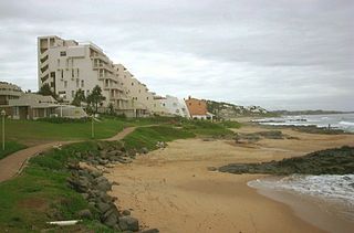
Kingsburgh is a coastal resort town along the South Coast of KwaZulu-Natal, South Africa, approximately 32 kilometres south-west of Durban.

oThongathi Place in KwaZulu-Natal, South Africa

oThongathi, previously and still commonly known as Tongaat, is a town in KwaZulu-Natal, South Africa, about 40 kilometres (25 mi) north of Durban and 28 kilometres (17 mi) south of KwaDukuza. It now forms part of eThekwini Metropolitan Municipality, or the Greater Durban area. The area is home to the oldest Indian community in South Africa, having been where the first indentured Indian laborers settled in 1860 to work in the sugar-cane plantations. Much of the architectural style in the town was the work of Ivan Mitford-Barberton, and many buildings are in the Cape Dutch style of architecture.

<span class="mw-page-title-main">N2 (South Africa)</span> National road in South Africa

The N2 is a national route in South Africa that runs from Cape Town through George, Gqeberha, East London, Mthatha, Port Shepstone and Durban to Ermelo. It is the main highway along the Indian Ocean coast of the country. Its current length of 2,255 kilometres (1,401 mi) makes it the longest numbered route in South Africa.

Mangosuthu University of Technology (MUT) is a university of technology situated in Umlazi near the city of Durban, South Africa, on a site overlooking the Indian Ocean. MUT is located in the academic hub in the eThekwini metropole. It is a residential university.

<span class="mw-page-title-main">Bluff, KwaZulu-Natal</span> Place in KwaZulu-Natal, South Africa

Bluff or The Bluff is a geographical area, containing eight suburbs in Durban, eThekwini Metropolitan Municipality, KwaZulu-Natal Province, South Africa. The Bluff forms a large part of the South Durban Basin, a sub-region located south of Durban.

Griffiths Mlungisi Mxenge was born in KwaRayi, a rural settlement outside of King Williams Town, Eastern Cape. He was a civil rights lawyer, a member of the African National Congress (ANC) and a South African anti-apartheid activist.

La Lucia is a wealthy suburb located in uMhlanga, north of Durban, in the KwaZulu-Natal province of South Africa. It was named after Lucia Michel. She and her husband Albert Michel founded the sugar cane farm La Lucia.

The M4 is a north–south metropolitan route in the eThekwini Metropolitan Municipality and partially in the KwaDukuza Local Municipality, South Africa. It runs from the N2 at the defunct Durban International Airport to Ballito via the Durban Central Business District (CBD) and uMhlanga. The sections between the airport and the southern edge of the CBD, and between the northern edge of the CBD and the exit to uMhlanga are classified as freeway. On the section from the southern edge of the CBD to the Bram Fischer Street/Soldier's Way junction, the M4 is cosigned with the R102.

<span class="mw-page-title-main">Metrorail KwaZulu-Natal</span> Commuter rail system in the Greater Durban region

Metrorail KwaZulu-Natal is a network of commuter rail services in and around the city of Durban in KwaZulu-Natal province, South Africa. It is operated by Metrorail, a division of the Passenger Rail Agency of South Africa (PRASA).

Umbogintwini is a suburb located approximately 23 km south-west of Durban, in the KwaZulu-Natal province of South Africa and forms part of the eThekwini Metropolitan Municipality.

Prospecton is an industrial suburb located south of Durban in KwaZulu-Natal, South Africa.

KwaMakhutha is a township in KwaZulu-Natal, South Africa, located south-west of Durban and means "at the Makhutha location".

The M5 is a long metropolitan route in the eThekwini Metropolitan Municipality, South Africa. It starts in KwaMashu in the north-western townships of Durban. It passes through the townships of KwaMashu, Newlands East, Newlands West, Ntuzuma and KwaDabeka. It then passes through the industrial town of New Germany and the leafy towns of Pinetown and Queensburgh before entering Durban and ending with the R102 in the Umbilo industrial area.

Mobeni is a suburb of Durban in KwaZulu-Natal, South Africa and forms part of the heavily industrialised South Durban Basin, a sub-region south of Durban.

The M30 also named Griffiths Mxenge Highway is a metropolitan route in the eThekwini Metropolitan Municipality, South Africa linking the city of Durban with Umbumbulu, south-west of the city via Umlazi.

References

  1. 1 2 3 4 "Main Place Umlazi". Census 2011.
  2. Staff Writer. "These are the biggest townships in South Africa". businesstech.co.za. Retrieved 20 December 2018.
  3. "Umlazi topographic map, elevation, terrain". Topographic maps. Retrieved 10 November 2022.
  4. South Africa. "Ogwini Comprehensive Technical High School, in Umlazi P, Umlazi, KwaZulu-Natal". Pathfinda.com. Retrieved 2 July 2016.
  5. "Samke Makhoba | TVSA". www.tvsa.co.za. Retrieved 22 February 2019.