
Catonsville is a census-designated place (CDP) in Baltimore County, Maryland, United States. The population was 41,567 at the 2010 census. The community lies to the west of Baltimore along the city's border. Catonsville contains the majority of the University of Maryland, Baltimore County (UMBC), a major public research university with close to 14,000 students.

Streetcars in Washington, D.C. transported people across the city and region from 1862 until 1962.
The Los Angeles Railway was a system of streetcars that operated in Central Los Angeles and surrounding neighborhoods between 1895 and 1963. The system provided frequent local services which complimented the Pacific Electric "Red Car" system's largely commuter-based interurban routes. The company carried many more passengers than the Red Cars, which served a larger and sparser area of Los Angeles.
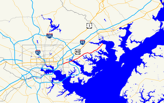
Maryland Route 150 (MD 150) is a state highway in the U.S. state of Maryland. Known for most of its length as either Eastern Avenue or Eastern Boulevard, the highway runs 13.01 miles (20.94 km) from U.S. Route 40 (US 40) in Baltimore east to Graces Quarters Road in Chase in eastern Baltimore County. MD 150 connects Baltimore with its southeastern suburbs of Dundalk, Essex, and Middle River. The state highway also links those communities with Interstate 95 (I-95), I-695, I-895, and Martin State Airport. MD 150 was constructed from Baltimore to Middle River and in Chase in the mid-1920s. The road was completed through Middle River in the early 1930s. Between 1942 and 1944, MD 150 was reconstructed as a four-lane divided highway with interchanges to improve access between Baltimore and the Glenn L. Martin Company aircraft manufacturing plant in Middle River. The highway has followed several routes since it was extended west into the city of Baltimore in the mid-1940s; the present route in East Baltimore was established shortly after 2000.

Streetcars and interurbans operated in the Maryland suburbs of Washington, D.C., between 1890 and 1962. Lines in Maryland were established as separate legal entities, but eventually they were all owned or leased by DC Transit. Unlike the Virginia lines, the Washington and Maryland lines were scheduled as a single system. Most of the streetcars were built with grand plans in mind, but none succeeded financially. A combination of the rise of the automobile, various economic downturns and bustitution eventually spelled the end of streetcars in southern Maryland.

The Third Avenue Railway System (TARS), founded 1852, was a streetcar system serving the New York City boroughs of Manhattan and the Bronx along with lower Westchester County. For a brief period of time, TARS also operated the Steinway Lines in Long Island City.
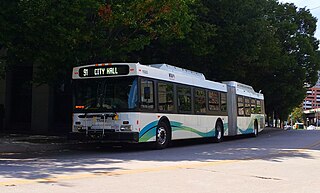
Route 91 is a bus route operated by the Maryland Transit Administration in Baltimore. The line currently runs from Sinai Hospital to City Hall, serving the communities of Pimlico, Arlington, Walbrook, and Bolton Hill, Coppin State College and the corridors of Garrison Boulevard and Eutaw Place. The line has the second-highest farebox recovery rate of all MTA bus lines.

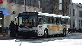
Route 14 is a bus route operated by the Maryland Transit Administration between Baltimore and Annapolis, Maryland. At most times, the line operates from the Patapsco Light Rail Stop in southern Baltimore with short turns at Jumper's Hole in Pasadena. The bus route, one of the longest local routes operated by MTA, is the successor to the Baltimore and Annapolis Railroad interurban, and mainly operates along the parallel Ritchie Highway, serving Brooklyn Park, Glen Burnie, Pasadena, and Severna Park. When the Light Rail is not running, Route 14 runs all the way to downtown Baltimore, mostly along Hanover Street.
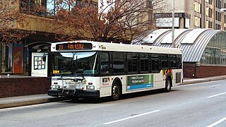
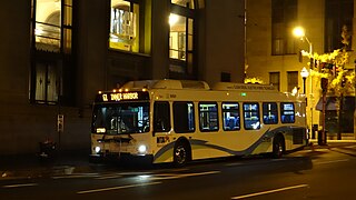
Route 23 is a bus route operated by the Maryland Transit Administration in Baltimore and its suburbs. The line currently runs from the Wal-Mart parking lot in Catonsville, Maryland east through downtown Baltimore to the Fox Ridge community in Essex, serving the corridors of Edmondson Avenue on the west side and Eastern Avenue on the east, and the communities of Edmondson Village, Allendale, Rosemont, Patterson Park, and Eastpoint, and is one of the most heavily used bus routes operated by the MTA.
LocalLink 95 is a bus route operated by the Maryland Transit Administration in Baltimore. The line currently runs from the intersection of Roland Avenue and Lake Avenue in Roland Park south to the Inner Harbor via Roland Avenue, University Parkway, Charles Street and St. Paul Street.

Route 7 was a bus route operated by the Maryland Transit Administration in Baltimore. The line, which operated between 1959 and 2017, ran from Canton, Baltimore to the Mondawmin Metro Subway Station, serving the communities of Butcher's Hill, Little Italy, and Sandtown-Winchester.

Route 10 is a bus route operated by the Maryland Transit Administration in Baltimore and its suburbs. The line currently runs from the Wal-Mart parking lot in Catonsville to Bullneck Road/Turner's Station Dundalk mostly along the corridors of Frederick Road on the west side and Eastern Avenue on the east side, serving the communities of Yale Heights, Pigtown, downtown Baltimore, Fells Point, and Highlandtown.
Route 13 is a bus route operated by the Maryland Transit Administration in Baltimore. The line currently runs from Walbrook Junction in West Baltimore to Canton, mostly along North Avenue. The line has two main branches, both operating to Canton: one that operates via Fells Point and the other via Linwood and East Streets. Both these branches serve Johns Hopkins Hospital. Additionally, selected trips on weekdays and Saturdays operate to the block of Milton Avenue, Federal Street, and Patterson Park Avenue.
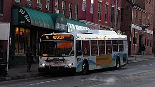
Route 15 is a bus route operated by the Maryland Transit Administration in Baltimore and its suburbs. The line currently runs from Security Square Mall, Westview Mall, Windsor Hills, or Walbrook Junction through downtown Baltimore and northeast to Overlea, with selected peak hour express trips to Perry Hall. The main roads on which it operates include Security Boulevard, Windsor Mill Road, Forest Park Avenue, Poplar Grove Street, Edmondson Avenue, Saratoga Street, Gay Street, and Belair Road, and is one of the most heavily used bus routes operated by the MTA.

Route 36 is a bus route operated by the Maryland Transit Administration in Baltimore and its suburbs. The line currently runs from the intersection of York Road and Northern Parkway to the Riverview, with some trips making short turns at Washington Boulevard and Monroe Street. The line serves the corridors of The Alameda, Kirk Avenue, Guilford Avenue, and Washington Boulevard.

Maryland Route 166 is a state highway in the U.S. state of Maryland. The state highway runs 2.71 miles (4.36 km) from Interstate 195 (I-195) in Arbutus north to MD 144 in Catonsville. MD 166 consists of two sections: a short freeway section that serves as a northern continuation of I-195 and provides access to the University of Maryland, Baltimore County (UMBC), and a segment of Rolling Road, a major north–south highway in western Baltimore County. Rolling Road dates to the colonial era as a highway used to transport tobacco from plantations to river ports. North Rolling Road, which connects Catonsville with Woodlawn and Milford Mill, has always been a county highway. South Rolling Road was constructed as a state highway by the early 1920s between what were to become U.S. Route 1 and US 40. Parts of South Rolling Road were transferred to county maintenance after they were severed by the construction of I-95 and a freeway relocation of the southern end of MD 166 in the early 1970s.

Route 44 is a bus route operated by the Maryland Transit Administration in Baltimore and its suburbs. The line currently runs from Rosedale Industrial Park near Pulaski Highway just outside the Baltimore city limits on the east side of the city across the northern portion of the city to Security Square Mall, with selected peak hour trips to the Social Security Administration. Some early morning trips before 7 AM lay over at the Centers for Medicare and Medicaid Services (CMS) headquarters. The line operates mostly along Frankford Avenue, Echodale Avenue, East Belvedere Avenue, Northern Parkway, Rogers Avenue, and Gwynn Oak Avenue, serving the communities of Gardenville, Hamilton, Belvedere Park, Homeland, Roland Park, Pimlico, and Arlington, and the western suburb of Woodlawn.

LocalLink 22 is a bus route operated by the Maryland Transit Administration in Baltimore. The line currently operates between the Mondawmin Metro Subway Station and Bayview Medical Center, serving Television Hill, the Woodberry Light Rail Stop, Hampden, The Rotunda, Homewood, Johns Hopkins University, Waverly, Belair-Edison, and Highlandtown.

Route 57 is a bus route operated by the Maryland Transit Administration in Baltimore and its suburbs. The line currently runs from the Rogers Avenue Metro Subway Station in Northwest Baltimore to Security Square Mall, with selected trips to the Social Security Administration headquarters in Woodlawn. The line serves the corridor of Gwynn Oak Avenue and the communities of Howard Park, Gwynn Oak, and Windsor Mill.

Express BusLink 150 is a bus route operated by the Maryland Transit Administration in Baltimore, Ellicott City, and Columbia, Maryland. The line currently operates between the Village of Harper's Choice in Columbia and Harbor East, mostly via US-29 and US-40, serving The Mall in Columbia and Catonsville.
