University, Mississippi

Last updated

University, Mississippi
USA Mississippi location map.svg
Red pog.svg
University
Location in Mississippi
Usa edcp location map.svg
Red pog.svg
University
Location in the United States
Coordinates: 34°21′55″N89°32′6″W / 34.36528°N 89.53500°W / 34.36528; -89.53500
CountryUnited States
State Mississippi
County Lafayette
Area
[1]
  Total0.70 sq mi (1.82 km2)
  Land0.70 sq mi (1.82 km2)
  Water0.00 sq mi (0.00 km2)
Elevation
500 ft (200 m)
Population
 (2020)
  Total4,696
  Density6,670.45/sq mi (2,574.13/km2)
Time zone UTC−6 (Central (CST))
  Summer (DST) UTC−5 (CDT)
ZIP Code
38677
Area code 662
FIPS code 28-75520
GNIS feature ID2586613

University is a census-designated place (CDP) and the official name for an area covering a portion of the University of Mississippi (Ole Miss) campus, in Lafayette County, Mississippi, United States. [2] The CDP is surrounded by the city of Oxford. [3] [4] Its official United States Postal Service designation is "University, Mississippi", with a ZIP Code of 38677.

Contents

The population at the 2010 census was 4,202, [5] while the 2014 enrollment for Ole Miss was 20,112 in 2014. [6]

The University CDP is an enclave surrounded by the city of Oxford, west of its downtown area. It has an area of 0.70 square miles (1.82 km2), all of it recorded as land. [7]

Demographics

Historical population
CensusPop.Note
2010 4,202
2020 4,69611.8%
U.S. Decennial Census [8]

Education

The CDP is in the Oxford School District. [9] The district operates Oxford High School.

Climate

According to the Köppen Climate Classification system, university has a humid subtropical climate, abbreviated "Cfa" on climate maps. The hottest temperature recorded in University was 110 °F (43.3 °C) on September 5, 1925, while the coldest temperature recorded was −13 °F (−25.0 °C) on January 21, 1985. [10]

Climate data for University, Mississippi, 1991–2020 normals, extremes 1893–present
MonthJanFebMarAprMayJunJulAugSepOctNovDecYear
Record high °F (°C)80
(27)
84
(29)
91
(33)
93
(34)
98
(37)
104
(40)
108
(42)
107
(42)
110
(43)
98
(37)
89
(32)
81
(27)
110
(43)
Mean maximum °F (°C)72.1
(22.3)
75.2
(24.0)
82.2
(27.9)
87.0
(30.6)
90.8
(32.7)
94.9
(34.9)
97.1
(36.2)
97.7
(36.5)
94.8
(34.9)
89.4
(31.9)
80.1
(26.7)
72.8
(22.7)
98.8
(37.1)
Average high °F (°C)52.3
(11.3)
57.1
(13.9)
65.8
(18.8)
74.2
(23.4)
82.0
(27.8)
88.6
(31.4)
91.3
(32.9)
91.0
(32.8)
86.2
(30.1)
76.1
(24.5)
64.3
(17.9)
55.0
(12.8)
73.7
(23.1)
Daily mean °F (°C)41.4
(5.2)
45.1
(7.3)
53.5
(11.9)
61.6
(16.4)
70.4
(21.3)
77.7
(25.4)
80.7
(27.1)
79.8
(26.6)
73.9
(23.3)
62.6
(17.0)
51.9
(11.1)
44.2
(6.8)
61.9
(16.6)
Average low °F (°C)30.6
(−0.8)
33.8
(1.0)
41.2
(5.1)
48.9
(9.4)
58.9
(14.9)
66.8
(19.3)
70.2
(21.2)
68.6
(20.3)
61.6
(16.4)
49.2
(9.6)
39.5
(4.2)
33.3
(0.7)
50.2
(10.1)
Mean minimum °F (°C)12.2
(−11.0)
17.3
(−8.2)
22.5
(−5.3)
31.5
(−0.3)
42.2
(5.7)
55.3
(12.9)
61.1
(16.2)
59.3
(15.2)
45.7
(7.6)
32.2
(0.1)
22.3
(−5.4)
17.5
(−8.1)
9.7
(−12.4)
Record low °F (°C)−13
(−25)
−10
(−23)
7
(−14)
21
(−6)
31
(−1)
43
(6)
50
(10)
48
(9)
32
(0)
20
(−7)
6
(−14)
−10
(−23)
−13
(−25)
Average precipitation inches (mm)5.13
(130)
5.82
(148)
5.61
(142)
6.30
(160)
5.35
(136)
5.22
(133)
4.35
(110)
3.90
(99)
3.99
(101)
4.10
(104)
4.30
(109)
6.45
(164)
60.52
(1,536)
Average snowfall inches (cm)0.8
(2.0)
0.2
(0.51)
0.1
(0.25)
0.0
(0.0)
0.0
(0.0)
0.0
(0.0)
0.0
(0.0)
0.0
(0.0)
0.0
(0.0)
0.0
(0.0)
0.0
(0.0)
0.1
(0.25)
1.2
(3.01)
Average precipitation days (≥ 0.01 in)12.010.811.710.311.010.210.08.87.47.99.812.2122.1
Average snowy days (≥ 0.1 in)0.60.40.10.00.00.00.00.00.00.00.00.31.4
Source 1: NOAA [11]
Source 2: National Weather Service [10]

Related Research Articles

<span class="mw-page-title-main">Lafayette County, Mississippi</span> County in Mississippi, United States

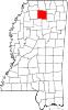
Lafayette County is a county in the U.S. state of Mississippi. At the 2020 census, the population was 55,813. Its county seat is Oxford. The local pronunciation of the name is "la-FAY-et." The county's name honors Marquis de Lafayette, a French military hero and American general who fought during the American Revolutionary War.

<span class="mw-page-title-main">College, Alaska</span> Census-designated place in Alaska, United States

College is a census-designated place (CDP) in Fairbanks North Star Borough, Alaska, United States. It is part of the Fairbanks, Alaska Metropolitan Statistical Area. As of the 2020 census, the population was 11,332, down from 12,964 in 2010. College is the third-most populated CDP in Alaska.

<span class="mw-page-title-main">Oxford, Mississippi</span> City in Mississippi, United States

Oxford is the 14th most populous city in Mississippi, and the county seat of Lafayette County, 75 miles (121 km) southeast of Memphis. A college town, the University of Mississippi or "Ole Miss" is adjacent to the city. Founded in 1837, it is named for Oxford, England.

<span class="mw-page-title-main">Bedford, Wyoming</span> Census-designated place in Wyoming, United States

Bedford is a census-designated place (CDP) in Lincoln County, Wyoming, United States. The population was 465 at the 2020 census.

Mississippi State is a census-designated place in Oktibbeha County, Mississippi, United States. It is the official designated name for the area encompassing Mississippi State University, which lies partly in the nearby incorporated municipality of Starkville. The population at the 2020 census was 4,968.

<span class="mw-page-title-main">Flaming Gorge, Utah</span> CDP in Utah, United States

Flaming Gorge is a census-designated place in Daggett County, Utah, United States. The population was 83 at the 2010 census.

<span class="mw-page-title-main">Winterville, Mississippi</span> Census-designated place in Mississippi, United States

Winterville is a census-designated place and unincorporated community located in Washington County, Mississippi, near Mississippi Highway 1. Winterville is approximately 3 miles (4.8 km) north of Greenville, the county seat, and approximately 4 miles (6.4 km) south of Lamont.

<span class="mw-page-title-main">Panther Burn, Mississippi</span> Census-designated place in Mississippi, United States

Panther Burn is a census-designated place and unincorporated community located along U.S. Route 61 in northwestern Sharkey County, Mississippi, United States. It has a post office with the ZIP code of 38765.

Delta City is a census-designated place and unincorporated community located on Mississippi Highway 434 in Sharkey County, Mississippi. Delta City is approximately 6 miles (9.7 km) east of Panther Burn and approximately 5 miles (8.0 km) north of Nitta Yuma. Although an unincorporated community, Delta City has a zip code of 39061.

<span class="mw-page-title-main">Moselle, Mississippi</span> Unincorporated community in Mississippi, US

Moselle is a census-designated place and unincorporated community in southern Jones County, Mississippi. The community is part of the Laurel micropolitan area.

<span class="mw-page-title-main">Eastabuchie, Mississippi</span> Community in Mississippi, U.S.

Eastabuchie is a census-designated place and unincorporated community in southwestern Jones County, Mississippi. It is located along U.S. Route 11, just north of the Forrest County line. the community has a post office with the ZIP code 39436. Eastabuchie is part of the Laurel Micropolitan Statistical Area.

Grace is a census-designated place and unincorporated community in Issaquena County, Mississippi, United States. It is located several miles northeast of Mayersville.

<span class="mw-page-title-main">Nitta Yuma, Mississippi</span> Census-designated place in Mississippi, United States

Nitta Yuma is a census-designated place and unincorporated community located in Sharkey County, Mississippi, United States. Nitta Yuma is located along U.S. Route 61, approximately four miles north of Anguilla.

<span class="mw-page-title-main">Scott, Mississippi</span> Census-designated place in Mississippi, United States

Scott is a census-designated place and unincorporated community located in Bolivar County, Mississippi, United States on Mississippi Highway 1. Scott is approximately 5 miles (8.0 km) north of Lamont and approximately 7 miles (11 km) south of Benoit.

<span class="mw-page-title-main">Skene, Mississippi</span> Census-designated place in Mississippi, United States

Skene is a census-designated place and unincorporated community located in Bolivar County, Mississippi, United States on Mississippi Highway 446. Skene is approximately 3 miles (4.8 km) west of Boyle and approximately 7 miles (11 km) north of Shaw. Skene was a station on the Boyle and Sunflower branch of the former Yazoo and Mississippi Valley Railroad.

<span class="mw-page-title-main">Symonds, Mississippi</span> Census-designated place in Mississippi, United States

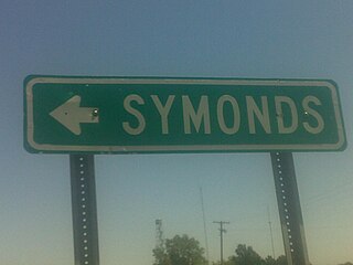
Symonds is a census-designated place and unincorporated community located in Bolivar County, Mississippi, United States. Symonds is approximately 3 miles (4.8 km) southeast of Malvina and approximately 4 miles (6.4 km) northwest of Pace. Symonds is located on the former Yazoo and Mississippi Valley Railroad.

Longview is a census-designated place and unincorporated community located along Mississippi Highway 12 in Oktibbeha County, Mississippi. Longview is approximately 7 miles (11 km) southwest of Starkville and approximately 8 miles (13 km) northeast of Sturgis.

Paris is a census-designated place and unincorporated community in Lafayette County, Mississippi, United States. Paris is located at the junction of Mississippi Highway 9W and Mississippi Highway 315 10 miles (16 km) east of Water Valley.

Tula is a census-designated place and unincorporated community in Lafayette County, Mississippi, United States. Tula is located on Mississippi Highway 331 7.5 miles (12.1 km) west-southwest of Toccopola.

Mississippi Valley State University is a census-designated place in Leflore County, Mississippi, United States. The population at the 2020 census was 805. It is the location of Mississippi Valley State University and is adjacent to Itta Bena.

References

  1. "2020 U.S. Gazetteer Files". United States Census Bureau. Retrieved July 24, 2022.
  2. "2020 CENSUS - CENSUS BLOCK MAP: University CDP, MS" (PDF). U.S. Census Bureau . Retrieved August 14, 2022. Univ of Mississippi (blue text)
    "2020 CENSUS - CENSUS BLOCK MAP: Oxford city, MS" (PDF). U.S. Census Bureau. p. 1 (PDF p. 2/5). Retrieved August 14, 2022. Univ of Mississippi
  3. U.S. Geological Survey Geographic Names Information System: University Census Designated Place
  4. U.S. Geological Survey Geographic Names Information System: Oxford
  5. "Total Population: 2010 Census DEC Summary File 1 (P1), University CDP, Mississippi". data.census.gov. U.S. Census Bureau. Retrieved March 30, 2020.
  6. "Quick Facts | University of Mississippi". www.olemiss.edu. Retrieved September 10, 2015.
  7. "U.S. Gazetteer Files: 2019: Places: Mississippi". U.S. Census Bureau Geography Division. Retrieved March 30, 2020.
  8. "Census of Population and Housing". Census.gov. Retrieved June 4, 2016.
  9. "2020 CENSUS - SCHOOL DISTRICT REFERENCE MAP: Lafayette County, MS" (PDF). U.S. Census Bureau . Retrieved July 21, 2022. - Text list
  10. 1 2 "NOAA Online Weather Data – NWS Memphis". National Weather Service. Retrieved February 27, 2023.
  11. "U.S. Climate Normals Quick Access – Station: University, MS". National Oceanic and Atmospheric Administration. Retrieved February 27, 2023.