
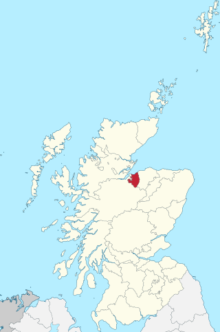
Urquhart and Logie Wester is a parish within the county of Ross and Cromarty, Scotland. It is situated in the area known as the Black Isle and is in the Highland (council area).
Urquhart and Logie Wester is a parish within the county of Ross and Cromarty, Scotland. It is situated in the area known as the Black Isle and is in the Highland (council area).
The parishes of Urquhart and Logiebride were united to form one parish in 1845. [1] Logiebride forms the western half of the parish hence Logie Wester, and Urquhart forms the eastern half. Both Urquhart and Logiebride previously had their own parish churches, both of which are now in ruins. [2] However today there are several more modern churches in the parish of Urquhart and Logie Wester. The Battle of Logiebride took place in 1597.
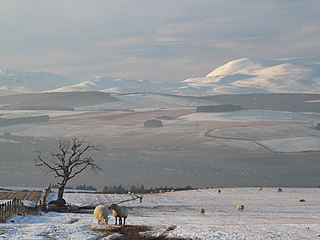
A medieval parish and a parish for civil and religious purposes from the sixteenth century until 1975. The boundaries of the civil parish were altered by the Boundary Commissioners in 1891. [3] The largest village within the parish is Conon Bridge. Other settlements within the parish include the village Easter Kinkell, the hamlet Bishop Kinkell and the small village Culbokie.

The Highlands is a historical region of Scotland. Culturally, the Highlands and the Lowlands diverged from the Late Middle Ages into the modern period, when Lowland Scots language replaced Scottish Gaelic throughout most of the Lowlands. The term is also used for the area north and west of the Highland Boundary Fault, although the exact boundaries are not clearly defined, particularly to the east. The Great Glen divides the Grampian Mountains to the southeast from the Northwest Highlands. The Scottish Gaelic name of A' Ghàidhealtachd literally means "the place of the Gaels" and traditionally, from a Gaelic-speaking point of view, includes both the Western Isles and the Highlands.

Perthshire, officially the County of Perth, is a historic county and registration county in central Scotland. Geographically it extends from Strathmore in the east, to the Pass of Drumochter in the north, Rannoch Moor and Ben Lui in the west, and Aberfoyle in the south; it borders the counties of Inverness-shire and Aberdeenshire to the north, Angus to the east, Fife, Kinross-shire, Clackmannanshire, Stirlingshire and Dunbartonshire to the south and Argyllshire to the west. It was a local government county from 1890 to 1930.

Cromartyshire is a historic county in the Highlands of Scotland, comprising the medieval "old shire" around the county town of Cromarty and 22 enclaves and exclaves transferred from Ross-shire in the late 17th century. The largest part, six times the size of the old shire, is Coigach, northwest from Ullapool. In 1890, Cromartyshire was merged with Ross-shire into the administrative county of Ross and Cromarty, which in 1975 was merged into the new council area of Highland.

Ross and Cromarty, also referred to as Ross-shire and Cromartyshire, is a variously defined area in the Highlands and Islands of Scotland. There is a registration county and a lieutenancy area in current use, the latter of which is 8,019 square kilometres in extent. Historically there has also been a constituency of the Parliament of the United Kingdom, a local government county, a district of the Highland local government region and a management area of the Highland Council. The local government county is now divided between two local government areas: the Highland area and Na h-Eileanan Siar. Ross and Cromarty border Sutherland to the north and Inverness-shire to the south.

Caithness is a historic county, registration county and lieutenancy area of Scotland.
Moray; or Morayshire, called Elginshire until 1919, is a historic county, registration county and lieutenancy area of Scotland, bordering Nairnshire to the west, Inverness-shire to the south, and Banffshire to the east. It was a local government county, with Elgin the county town, until 1975. The county was officially called Elginshire, sharing the name of the Elginshire parliamentary constituency, so named since 1708.

Stirlingshire or the County of Stirling is a historic county and registration county of Scotland. Its county town is Stirling.
The County of Nairn is a historic county, registration county and lieutenancy area of Scotland. The county was used for local administration until the county council, based at the county town of Nairn, was abolished in 1975 under the Local Government (Scotland) Act 1973, the area becoming one of the eight districts of the two-tier Highland region. This arrangement ended in 1996 when the Highland council area was made a unitary authority.

Skye and Lochalsh is one of eight former local government districts of the two-tier Highland region of Scotland. The main offices of the Skye and Lochalsh district council were in Portree, on the Isle of Skye.
EastAberdeenshire was a Scottish county constituency of the House of Commons of the Parliament of the United Kingdom from 1868 to 1918 and from 1950 to 1983. It elected one Member of Parliament (MP) by the first past the post system of election.
The Diocese of Moray was one of the most important of the medieval dioceses of the Roman Catholic Church in Scotland. Its territory was in central northern Scotland.

The Diocese of Ross was an ecclesiastical territory or diocese in the Highland region of Scotland during the Middle Ages and Early modern period. The Diocese was led by the Bishop of Ross, and the cathedral was, latterly, at Fortrose. The bishops of the Early Church were located at Rosemarkie. The diocese had only one Archdeacon, the Archdeacon of Ross, first attested in 1223 with the appearance of Archdeacon Robert, who was consecrated bishop of Ross on 21 June 1249 x 20 June 1250. There is only one known Dean of Christianty (sic), one Donald Reid called the dean of christianty of Dingwall on 12 June 1530.

Inverness-shire is a historic county, registration county and lieutenancy area of Scotland. Covering much of the Highlands and Outer Hebrides, it is Scotland's largest county, though one of the smallest in population, with 67,733 people or 1.34% of the Scottish population.
Easter Kinkell is a rural village, in the parish of Urquhart and Logie Wester, in the area known as Black Isle, in the county of Ross-shire, Scottish Highlands. It is also in the Scottish council area of Highland.

Fortrose Cathedral was the episcopal seat (cathedra) of the medieval Scottish diocese of Ross in the Highland region of Scotland. It is probable that the original site of the diocese was at Rosemarkie, but by the 13th century the canons had relocated a short distance to the south-west, to the site known as Fortrose or Chanonry. According to Gervase of Canterbury, in the early 13th century the cathedral of Ross was manned by Céli Dé (culdees).

Glenurquhart or Glen Urquhart is a glen running to the west of the village of Drumnadrochit in the Highland council area of Scotland.
Kinkell may refer to:
Logie is a parish and village in east Fife, Scotland, 5 miles north-east of Cupar.
Strathglass is a strath or wide and shallow valley in the Northwest Highlands of Scotland down which runs the meandering River Glass from the point at which it starts at the confluence of the River Affric and Abhainn Deabhag to the point where, on joining with the River Farrar at Struy, the combined waters become the River Beauly.
57°34′N4°23′W / 57.57°N 4.39°W
| | This Highland location article is a stub. You can help Wikipedia by expanding it. |