Val Vogna

Last updated
Val Vogna
Val Vogna-Sant Antonio under snow.jpg
Sant'Antonio, Val Vogna
Italy provincial location map 2016.svg
Red pog.svg
Val Vogna
Floor elevation1100-3200
Long-axis directioneast-west
Geography
Population centersRiva Valdobbia
Borders onValle d'Otro, Valle Artogna, Valle del Lys
Coordinates 45°48′52.56″N7°55′49.4″E / 45.8146000°N 7.930389°E / 45.8146000; 7.930389
RiversVogna, Rissuolo

Val Vogna (I' Vejin [1] in Walser) is a lateral valley of Valsesia, inside the municipality of Riva Valdobbia, Italy.

Contents

West of Riva Valdobbia town, opens the Val Vogna, a side valley just in part served by paved road, on the old so-called Antica via d'Aosta “ancient Aosta Track”, [2] that united Riva Valdobbia to Gressoney-Saint-Jean through the colle di Valdobbia, the Valdobbia Pass.

Geography

Riva Valdobbia and the plains at confluence of the Sesia river and the Vogna torrent. Riva Valdobbia Plains-Vogna Valley.jpg
Riva Valdobbia and the plains at confluence of the Sesia river and the Vogna torrent.

Val Vogna opens west of Riva Valdobbia as a tributary of the Sesia Valley, with Val d'Otro north and Valle Artogna south. The general direction of the valley is East to West, with a slight moonshaped round turn pointing southwest at the end. There is only one notable tributary to the Vogna torrent, the Rissuolo torrent from Corno Bianco peak. The Rissuolo torrent makes a sharp cut in the middle of the north slope and reaches the main valley just west of La Peccia Hamlet, passing under the so-called Napoleonic Bridge.

Val Vogna was an emigration route, connecting Valsesia and Val d'Aosta through the colle Valdobbia pass (2480 m.).

The Antica via d'Aosta, later renamed via Regia (Royal path), follows the Vogna Valley up to the Napoleonic Bridge: here, the track leaves the main valley and climbs on the west bulkhead of the Rissuolo torrent valley, up to La Montata Hamlet (m. 1739) and then inside up to Colle Valdobbia and its Ospizio Sottile mountain hut.

On the pass, the rifugio Ospizio Sottile [3] was built in the 19th century to give shelter to people moving in and out the valley.

The “Aosta Track” was a major emigration route for most of the Sesia Valley people going for seasonal works abroad, mostly in France. The Sesia Valley goes basically eastward from the Monte Rosa to Varallo and the plains, so it was much shorter to pass the mountains in this relative safe spot.

As the migrations period were early in spring and late in the autumn, accidents due to bad weather and avalanches were frequent. A small provisionary hut was built, then the more substantial Ospizio in stone was built and dedicated to Nicolao Sottile, a priest that worked hard to find the money and volunteers for the building. Today, the Ospizio Sottile is a common destination for hikers and mountaineers.

Roads

Riva Valdobbia and the road going uphill into Vogna Valley Riva Valdobbia-hairpin turns up to Madonna delle Pose.jpg
Riva Valdobbia and the road going uphill into Vogna Valley

The valley has a paved road that starts near Riva Valdobbia's cemetery and goes up with few hairpin turns to the frazione (hamlet) Cà di Janzo and then gently uphill to Sant'Antonio Hamlet, obliterating the old tracks.

A dirt road begins from Sant'Antonio school house (now a restaurant and mountain hut in the GTA route [4] ) and goes up to just under La Peccia hamlet, but its use by offroad vehicles is restricted to farmers and local inhabitants.

Paths and hikes

Val Vogna offers many hikes. [5]

The emigration route connecting Valsesia and Val d'Aosta is the Antica via d'Aosta, later renamed via Regia (Royal path): This track is identified as No.201 [6] by Club Alpino Italiano, with a black 1 on a red/yellow/red triparted marking on stones and trees.

The track 1a [7] variant leaves the main one after La Montata and heads west on the woods on a short track to the Alpe Larecchio a former mountain lake basin, now a pasture land of marshes and grassfields, where a small nucleus of few houses is still in use to make Toma cheese.

Track 1c [8] gets a different route, from Alpe Larecchio to the west, up to Lago della Balma lake and then east on the peaks to reach the Colle Valdobbia.

Horace Bénédict de Saussure followed the entire valley on his Great Tour of the Alpes: [9] the GTA (or no.205 path [10] ) continued gently uphill from the Napoleonic Bridge following Vogna Torrent up to Alpe Maccagno another ancient pasture land at 2188m with few stone houses: this was the place of the original Toma del Maccagno cheese, while nowadays the name is in use by many producers, mostly on the Biella area that lay behind Passo del Maccagno Pass.

The CAI No.202 path [11] (bold 2 on red/yellow/red) leaves the dirt road midway between Sant'Antonio and La Peccia Hamlet to head up the east bank of the Rissuolo valley to Alpe Pile where the Rifugio Abate Carestia [12] mountain hut is located and then up to Lago Bianco and Lago Nero (White and Black Lake) or the Corno Bianco, 3320 m., the highest peak in the Vogna valley in ma maze of sub-tracks.

No.211 track gets to Corno Bianco in a more direct way, while No.210 starts from the lower hamlet of Ca di' Janzo, on the paved road, and climbs directly to Selveglio Hamlet and then the Cima Mutta peak 2135, the north bulkhead of the Vogna Valley overlooking Riva Valdobbia.

The frazioni Alte or Via della Fede ring

Oro hamlet in Vogna Valley seen from Selveglio hamlet along the "frazioni alte" trial Val Vogna-Oro seen from Selveglio.jpg
Oro hamlet in Vogna Valley seen from Selveglio hamlet along the "frazioni alte" trial

The above-mentioned tracks are mostly for experienced or dedicated hikers. A less strenuous but more interesting walk is the so-called giro delle Frazioni Alte, the Higher Hamlets ring. This ring is also marked as Via della Fede (Faith path) or "via dell'Arte" [13] by separate organizations, making some confusion in signs and names.

Basically, the tour touches all the hamlets of the lower Vogna valley, in an in-depth exploration of how Walsers lived up to the 19th century.

Each hamlet is a self-sufficient nucleus, with a fountain, a community oven and a small chapel, but they are few hundred meters away from one another creating a larger sparse community.

The ring has a roughly triangular fixed route, with the lower road (the above-mentioned No.1 track) from Ca' di Janzo and the higher path from Selveglio converging on La Peccia. The steep slope between the two paths doesn't allow to easily connect the lower and the higher hamlets, except for the Sant'Antonio-Rabernardo shortcut.

Related Research Articles

<span class="mw-page-title-main">Monte Rosa</span> Massif in Switzerland and Italy

Monte Rosa is a mountain massif in the eastern part of the Pennine Alps, on the border between Italy and Switzerland (Valais). The highest peak of the massif, amongst several peaks of over 4.000 m, is the Dufourspitze, the second highest mountain in the Alps and western Europe, after Mont Blanc. The east face of the Monte Rosa towards Italy has a height of about 2.400 meters and is the highest mountain wall of the Alps.

<span class="mw-page-title-main">Alagna Valsesia</span> Comune in Piedmont, Italy

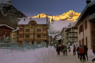
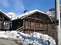
Alagna Valsesia is a comune and small village high in the Valsesia alpine valley in the province of Vercelli, Piedmont, northern Italy, a UNESCO World heritage site since 2013. It is a tourist place for mountaineering and winter sports, and it is internationally renowned for the freeride off-piste skiing. It is also the traditional starting point for the Margherita Hut climb, at 4,554 metres (14,941 ft) above sea level, the highest building in Europe. It was originally settled by Walser at the beginning of the 12th century. It is located at an elevation of 1,191 metres (3,907 ft) just south of the Monte Rosa, elevation 4,638 metres (15,217 ft) ; It is very close to Milan and to the international Milan–Malpensa Airport.

<span class="mw-page-title-main">Riva Valdobbia</span> Frazione in Piedmont, Italy

Riva Valdobbia is a fraction in the Province of Vercelli in the Italian region Piedmont, located about 90 kilometres (56 mi) north of Turin and about 70 kilometres (43 mi) northwest of Vercelli. It's an Italian town of 265 inhabitants located in the upper Valsesia, in the province of Vercelli, in Piedmont.

<span class="mw-page-title-main">Tanzio da Varallo</span> Italian painter

Antonio d'Enrico, called Tanzio da Varallo, or simply il Tanzio was an Italian painter of the late-Mannerist or early Baroque period.

<span class="mw-page-title-main">Geography of Piedmont</span>

The Geography of Piedmont is that of a territory predominantly mountainous, 43.3%, but with extensive areas of hills which represent 30.3% of the territory, and of plains (26.4%).

<span class="mw-page-title-main">Biellese Alps</span> Mountain range in Italy

The Biellese Alps are a sub-range of the Pennine Alps located between Piemonte and Aosta Valley (Italy).

<i>Grande Traversata delle Alpi</i>

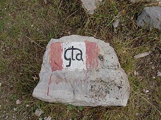
The Grande Traversata delle Alpi (GTA) is a long-distance hiking trail in the Italian region of Piedmont. In about 1,000 kilometres (620 mi) and 55 day hikes, it runs through the arc formed by the western Alps from the Pennine Alps through the Graian and Cottian Alps to the Maritime and Ligurian Alps. There are a number of transverse valleys along the route. Day hikes typically connect high-lying valley communities with each other via historic pass routes.

<span class="mw-page-title-main">Monte Barone</span> Mountain in Italy

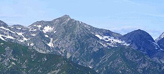
Monte Barone is a mountain of the Alpi Biellesi, a sub-range of the Pennine Alps. Due to its isolation it offers a noteworthy point of view towards the Po plain and can be seen from quite a long distance away.

<span class="mw-page-title-main">Corno Bianco</span> Mountain in Italy

Corno Bianco is a mountain of the Pennine Alps. It's a popular climbing destination of Valsesia.

<span class="mw-page-title-main">Monte Cresto</span> Mountain in Italy

Monte Cresto (2,548 m) is the third highest peak of the Province of Biella after Monte Mars (2,600 m) and Monte Bo (2,556 m).

<span class="mw-page-title-main">Passo dei Salati</span> Mountain pass in Italy

The Passo dei Salati is a mountain pass that between the Valsesia (Piedmont) and the Valley of Lys. The pass was also known by the name of the Colle Inferiore de Pisse. The term salati recalls of an ancient passage of Roman soldiers. It connects the villages of Alagna Valsesia and Gressoney-La-Trinité.

CoEur is a Christian devotional and hiking route in Italy and Switzerland. Its Italian subtitle, Nel cuore dei cammini d'Europa, translates as "In the heart of Europe's paths".

<span class="mw-page-title-main">Corno Bussola</span> Mountain in Italy

Corno Bussola is a 3,023 metres high peak on the Italian side of the Pennine Alps.

<span class="mw-page-title-main">Punta Leynir</span> Mountain in Italy

The Punta Leynir is a 3,238 metres high mountain belonging to the Italian side of Graian Alps.

<span class="mw-page-title-main">Cima Altemberg</span> Mountain in Italy

The Altemberg is a mountain in the Pennine Alps of north-western Italy; with an elevation of 2,395 m (7,858 ft) is the highest peak of the Alpi Cusiane.

<span class="mw-page-title-main">Monte Antoroto</span> Mountain in Italy

The Monte Antoroto is a mountain of the Ligurian Alps located in Piedmont.

<span class="mw-page-title-main">Monte Capezzone</span> Mountain in Italy

The Monte Capezzone is a mountain in the Pennine Alps of north-western Italy; with an elevation of 2,421 m (7,943 ft) is the highest peak of the Strona Valley.

<span class="mw-page-title-main">Monte I Gemelli</span> Mountain in Italy

The Monte I Gemelli is an Alpine mountain located between Aosta Valley and Piedmont.

<span class="mw-page-title-main">Monte Massone</span> Mountain in Italy

The Monte Massone, at an elevation of 2,161 m (7,090 ft), is a mountain of the Pennine Alps in North-western Italy.

<span class="mw-page-title-main">Palasinaz Lakes (Italy)</span> Group of Italian Lakes

The Palasinaz Lakes are a group of lakes located in the Italian Alps, in the Aosta Valley region of northern Italy.

References

  1. Sergio Maria Gilardino, I Walser e la loro lingua - Dal grande Nord alle Alpi, Alagna Valsesia, Zeisciu, 2008
  2. "La Montagna attraversata : pellegrini, soldati e mercanti (The Mountain crossed: pilgrims, soldiers and merchants)" (PDF) (in Italian).
  3. "Rifugio Ospizio Sottile m2480". Archived from the original on 2016-03-16.
  4. "Sant'Antonio di Val Vogna, community of Riva Valdobbia". gtapiemonte.it.
  5. "Sentieri e itinerari CAI Sezione di Varallo" (in Italian). Retrieved 2024-01-14.
  6. "Colle Valdobbia - Ospizio Sottile - Sentiero Ca' di Janzo-Colle Valdobbia - Ospizio Sottile - Valsesia".
  7. "Bivio sul sentiero 201-Pian del Celletto - Sentiero bivio sul sentiero 201-Pian del Celletto - Valsesia".
  8. "Colle Valdobbia - Ospizio Sottile per il Lago della Balma - Sentiero Alpe Larecchio-Colle Valdobbia - Ospizio Sottile - Valsesia".
  9. "Rifugio Rivetti – San Antonio Val Vogna". gtapiemonte.it.
  10. "Passo del Maccagno - Sentiero Loc. Peccia - Ponte Napoleonico-Passo del Maccagno - Valsesia".
  11. "Corno Bianco dal Vallone del Rissuolo - Sentiero Ca' di Janzo, bivio sull'itinerario 201-Corno Bianco - Valsesia".
  12. "Rifugio Carestia, Alpe Pile Val Vogna - Valsesia, Monte Rosa".
  13. "Sentieri dell'arte sui monte della Valsesia" (PDF) (in Italian). Retrieved 2024-01-14.