Papua is a province of Indonesia, comprising the northern coast of Western New Guinea together with island groups in Cenderawasih Bay to the west. It roughly follows the borders of Papuan customary region of Tabi Saireri. It is bordered by the sovereign state of Papua New Guinea to the east, the Pacific Ocean to the north, Cenderawasih Bay to the west, and the provinces of Central Papua and Highland Papua to the south. The province also shares maritime boundaries with Palau in the Pacific. Following the splitting off of twenty regencies to create the three new provinces of Central Papua, Highland Papua, and South Papua on 30 June 2022, the residual province is divided into eight regencies (kabupaten) and one city (kota), the latter being the provincial capital of Jayapura. The province has a large potential in natural resources, such as gold, nickel, petroleum, etc. Papua, along with four other Papuan provinces, has a higher degree of autonomy level compared to other Indonesian provinces.

Transport in Papua New Guinea is mainly based around roads and air travel. It is in many cases heavily limited by the mountainous terrain and copious amount of rainfall and frequent severe weather occurring in many locations, such as Lae, Papua New Guinea. The capital, Port Moresby, is not linked by road to any of the other major towns and many highland villages can only be reached by light aircraft or on foot.
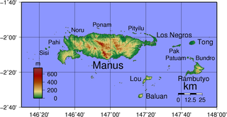
Manus Island is part of Manus Province in northern Papua New Guinea and is the largest of the Admiralty Islands. It is the fifth-largest island in Papua New Guinea, with an area of 2,100 km2 (810 sq mi), measuring around 100 km × 30 km. Manus Island is covered in rugged jungles which can be broadly described as lowland tropical rain forest. The highest point on Manus Island is Mt. Dremsel, 718 metres (2,356 ft) above sea level at the centre of the south coast. Manus Island is volcanic in origin and probably broke through the ocean's surface in the late Miocene, 8 to 10 million years ago. The substrate of the island is either directly volcanic or from uplifted coral limestone.
The Sko or Skou languages are a small language family spoken by about 7000 people, mainly along the Vanimo coast of Sandaun Province in Papua New Guinea, with a few being inland from this area and at least one just across the border in the Indonesian province of Papua.

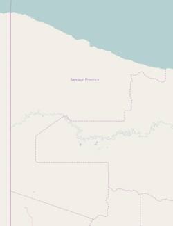
Sandaun Province is the northwesternmost mainland province of Papua New Guinea. It covers an area of 35,920 km2 and has a population of 248,411. The capital is Vanimo. In July 1998 the area surrounding the town Aitape was hit by an enormous tsunami caused by a Magnitude 7.0 earthquake which killed over 2,000 people. The five villages along the west coast of Vanimo towards the International Border are namely; Lido, Waromo, Yako, Musu and Wutung.
Jayapura is the capital and largest city of the Indonesian province of Papua. It is situated on the northern coast of New Guinea island and covers an area of 940.0 km2 (362.9 sq mi). The city borders the Pacific Ocean and Yos Sudarso Bay to the north, the sovereign state of Papua New Guinea to the east, Keerom Regency to the south, and Jayapura Regency to the west.
Kavieng is the capital of the Papua New Guinean province of New Ireland and the largest town on the island of the same name. The town is located at Balgai Bay, on the northern tip of the island. As of 2009, it had a population of 17,248.

West Papua, formerly Irian Jaya Barat, is a province of Indonesia. It covers the two western peninsulas of the island of New Guinea, the eastern half of the Bird's Head Peninsula and the Bomberai Peninsula, along with nearby smaller islands. The province is bordered to the north by the Pacific Ocean, to the west by the Halmahera Sea and the Ceram Sea, to the south by the Banda Sea, and to the east by the province of Central Papua and the Cenderawasih Bay. Manokwari is the province's capital and largest city. West Papua is the second-least populous province in Indonesia. It had a population of 1,134,068 at the 2020 Census, and the official estimate for mid 2021 was 1,156,840. However the total area and population will be reduced by the Parliamentary decision on 17 November 2022 to create a 38th province of Indonesia, comprising Sorong city and the regencies of Sorong, South Sorong, Raja Ampat, Maybrat and Tambrauw. The reduced West Papua Province will thus have a mid-2021 population estimated at only 551,791.

Wewak is the capital of the East Sepik province of Papua New Guinea. It is on the northern coast of the island of New Guinea. It is the largest town between Madang and Jayapura. It is the see city (seat) of the Roman Catholic Diocese of Wewak.
Tourism in Papua New Guinea is a fledgling industry but there are attractions for the potential visitor which include culture, markets, festivals, diving, surfing, hiking, fishing and the unique flora and fauna. Papua New Guinea receives an increasing number of visitors each year, with approximately 184,000 international arrivals in 2015.
PNG Air is an airline based on the grounds of Jacksons International Airport, Port Moresby, Papua New Guinea. It operates scheduled domestic and international flights, as well as contract corporate charter work. Its main base is Jacksons International Airport.
Lido is a large village on the north-western coast of Papua New Guinea, close to Vanimo, and approximately 45 minutes drive from the border with Indonesia. It is located in Bewani-Wutung Onei Rural LLG. The village forms a stereotypical tropical village, including coconut trees and grass-roofed huts.
Krisa also known as Krisi is a village in Bewani-Wutung Onei Rural LLG, Sandaun Province, Papua New Guinea, 20 kilometers south of the provincial capital of Vanimo. In the local language, the village, its people and the local language itself are all known as I'saka.

Dortheys Hiyo Eluay International Airport, also known as Sentani International Airport is an airport serving Jayapura, the capital of Papua province, Indonesia, on the island of New Guinea. It is located in the Sentani District, approximately 40 km from downtown Jayapura; the name 'Sentani' is taken from a Lake Sentani nearby. It is the easternmost airport in Indonesia, the main hub, and the largest airport in the island of New Guinea. On 14 October 2019 the management of the airport was taken over by PT Angkasa Pura I (Persero).

New Guinea is the world's second-largest island with an area of 785,753 km2 (303,381 sq mi). Located in Oceania in the southwestern Pacific Ocean, the island is separated from Australia by the 150-kilometre wide Torres Strait, though both landmasses lie on the same continental shelf. Numerous smaller islands are located to the west and east. The eastern half of the island is the major land mass of the independent state of Papua New Guinea. The western half, known as Western New Guinea, forms a part of Indonesia and is organized as the provinces of Papua, Central Papua, Highland Papua, South Papua, Southwest Papua, and West Papua. The largest cities on the island are Jayapura and Port Moresby.

Indonesia – Papua New Guinea relations are foreign relations between Indonesia and Papua New Guinea, two bordering countries north of Australia.
Pagi, or Bembi, is a Papuan language spoken by 2,000 people in five villages in Sandaun Province and in Vanimo District of Papua New Guinea, near the border with Indonesian Papua.
Vanimo is a Skou language of Papua New Guinea which extends from Leitre to Wutung on the Papua New Guinea - Indonesian border.

Southwest Papua is a province of Indonesia, and is a fraction of Western New Guinea. Despite being named southwest, it is a misnomer and this province is actually located in the northwest edge of Papua. The area that belongs to this province includes the Greater Sorong area which consists of Sorong City, Sorong Regency, South Sorong Regency, Maybrat Regency, Tambrauw Regency, and Raja Ampat Regency. The Draft Law (RUU) on the Establishment of the Southwest Papua Province has been passed into law and becomes the 38th province in Indonesia.