Bridgewater is an incorporated town in Rockingham County, Virginia, United States. The population was 6,596 at the 2020 census. It is included in the Harrisonburg, Virginia Metropolitan Statistical Area.

The Yarra River or historically, the Yarra Yarra River, is a perennial river in south-central Victoria, Australia.

Newport is a suburb in Melbourne, Victoria, Australia, 10 km (6.2 mi) south-west of Melbourne's Central Business District, located within the City of Hobsons Bay local government area. Newport recorded a population of 13,658 at the 2021 census.

Rockland Lake State Park is a 1,133-acre (4.59 km2) state park located in the hamlets of Congers and Valley Cottage in the eastern part of the Town of Clarkstown in Rockland County, New York, United States. The park is located on a ridge of Hook Mountain above the west bank of the Hudson River. Included within the park is the 256-acre (1.04 km2) Rockland Lake.

Albert Park is a large public park in the City of Port Phillip, an inner suburban LGA of Melbourne, Victoria, Australia. Located 3 km (1.9 mi) south of the Melbourne central business district, the park encompasses 2.25 km2 of parkland around the 1.8 km (1.1 mi) long Albert Park Lake, a 0.49 km2 Y-shaped artificial lake used both for water sports and public recreation.

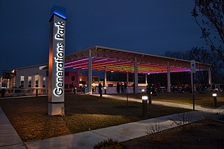
The Greater Grand Forks Greenway is a huge greenway bordering the Red River and Red Lake River in the twin cities of Grand Forks, North Dakota and East Grand Forks, Minnesota. At 2,200 acres (9 km2), the Greenway is more than twice the size of New York City's Central Park. It has an extensive, 20-mile (32 km) system of bike paths, which are used by bikers, walkers, joggers, and rollerbladers. In 2007, the system was designated as a National Recreation Trail by the National Park Service.

Ponoka is a town in central Alberta, Canada. It is located at the junction of Highway 2A and Highway 53, 59 kilometres (37 mi) north of Red Deer and 95 kilometres (59 mi) south of Edmonton.

The Forest Preserve District of Cook County is a governmental commission in Cook County, Illinois, that owns and manages land containing forest, prairie, wetland, streams, and lakes. These land holdings are primarily managed as undeveloped natural areas and for outdoor recreation. The Forest Preserve District encompasses approximately 70,000 acres of land or approximately 11% of the land in Cook County, which contains the city of Chicago and is the most densely populated urban metropolitan area in the Midwest. The Forest Preserves also owns the lands on which the Brookfield Zoo and the Chicago Botanic Garden operate. The Cook County Board of Commissioners also serves ex-officio as the board for the district. The Forest Preserve District headquarters is located in River Forest, Illinois.
Yarra Bend Park 260-hectare (640-acre) park in the Melbourne suburb of Kew. Located 4 km northeast of Melbourne's CBD, it is the largest area of natural bushland left in inner Melbourne. The most notable feature of the park is the Yarra River which flows for 12 km through it. The park hosts two golf courses, two historic boathouses, sheds and a number of cycle and walking trails. It receives approximately 1.5 million visitors per year.

Warriors' Path State Park is a 950-acre (3.84 km²) Tennessee State Park in Colonial Heights, Tennessee, an area within the city of Kingsport. It is named for the Great Indian Warpath that was used by the Iroquois in war raids with the Cherokee and other tribes. The park is located around the Fort Patrick Henry Reservoir and Duck Island on the South Fork Holston River. This land was acquired from the Tennessee Valley Authority in 1952.

Rossdale is a river valley neighbourhood in the city of Edmonton, Alberta, Canada, located immediately south of the downtown core. It is a popular residential neighbourhood with easy access to downtown, the University of Alberta, the Edmonton river valley park system, and other amenities.

Holiday Park is a neighbourhood in south-central Saskatoon, Saskatchewan. Located within Saskatoon's Ward 2, Councillor Hilary Gough represents the area's interests at City Hall.

William Hawrelak Park is a park in Edmonton, Alberta. Formerly known as Mayfair Park, it was initially going to be developed into a 500-lot subdivision; however, when the Strathcona Land Syndicate forfeited their taxes the city obtained the title for the land in 1922. This land lay unused until 1954, when Mayor William Hawrelak proposed to create a 350-acre (1.4 km2) riverside park in this area as it would “fit into the overall park development of the City along the lines of the zoo, and the golf courses and other picnic areas”. The digging of the man-made lakes began in 1959 and later was completed in 1964 but had few facilities. The official opening day of Mayfair Park was on Dominion Day, July 1, 1967. It was renamed in 1982 for Hawrelak, who died in office in 1975 while serving as mayor of Edmonton.

Buffalo Pound Provincial Park is in southern Saskatchewan, Canada, about 30 kilometres (19 mi) north-east of Moose Jaw and 86 kilometres (53 mi) north-west of the city of Regina. Access to the provincial park is from Highways 301 and 202.

The North Saskatchewan River valley parks system, also known as the Ribbon of Green or the River Valley Parks, is a continuous collection of urban parks around the North Saskatchewan River valley in the Edmonton Metropolitan Region of Alberta, Canada. The park system encompasses over 7,300 hectares of parkland, making it the largest contiguous area of urban parkland in the country. The park system is made up of over 30 provincial and municipal parks situated around the river from Devon to Fort Saskatchewan, with trails connecting most of the parks together.

Spokane, Washington has a rich sporting culture and the area residents are active in many spectator and participant sports. Although Spokane lacks any major, nationally recognized professional sports team, Spokane has a sports friendly atmosphere, and was recognized and rated #99 in the Sporting News 2006 "99 Best Sporting Cities" list. In 2009, Sports Business Journal rated Spokane as the fifth best minor league sports market in America out of 239 markets.

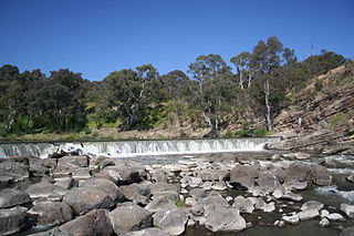
The Yarra River is a river in southern Victoria, Australia that flows through the city of Melbourne. There are many parklands, including state parks and national parks, that adjoin the river along its 250 km length. Every park listed has walking tracks, smaller parks usually have unsealed paths, while bigger parks will have sealed pathways suitable for walking and cycling. The Yarra River Trail runs along much of the length of the river's lower reaches through Melbourne. Most parks listed have parking available, the quality and quantity of which varies according to the size of the park. Dogs are not permitted in parklands adjoining the river unless otherwise stated in special off-lead areas.
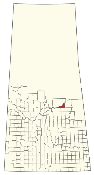
The Rural Municipality of Nipawin No. 487 is a rural municipality (RM) in the Canadian province of Saskatchewan within Census Division No. 14 and SARM Division No. 4.
Hermitage is a residential area in the northeast portion of the City of Edmonton in Alberta, Canada. It was established in 1970 through Edmonton City Council's adoption of the Hermitage General Outline Plan, which guides the overall development of the area.

Rundle Park is a municipal park in Edmonton, Canada, and a major park in the North Saskatchewan River Valley parks system. The park overlooks the North Saskatchewan River, and there is a pedestrian bridge that connects Gold Bar Park and Rundle Park together. The park features paved paths, sport amenities, and numerous ponds.