Victoria Swing Bridge

Last updated

Victoria Swing Bridge
Victoria Bridge (geograph 1904589).jpg
Coordinates 55°58′43″N3°10′12″W / 55.9787251°N 3.1699057°W / 55.9787251; -3.1699057
Crosses Water of Leith
Characteristics
Material Wrought iron
Total length212 feet (65 m)
Width24 feet (7.3 m)
Longest span120 feet (37 m)
History
Engineering design byRendel and Robertson
Construction start1871
Construction end1874
Construction cost£30,000
Location
Victoria Swing Bridge

The Victoria Swing Bridge is a swing bridge in Leith docks, Edinburgh, Scotland, which carries a dock road (and previously twin railway lines) across the Water of Leith at a point where it is canalised as the Inner Harbour.

Contents

History

Engraving of the bridge carrying a train from around 1879 Leith docks swing bridge-001.jpg
Engraving of the bridge carrying a train from around 1879

The bridge was built between 1871 and 1874 to service the new docks. [1] It was engineered by Rendel and Robertson, with J. H. Bostock as resident engineer. [1] McDonald & Grant were contractors for the foundations, and the bridge was built by the Skerne Iron Works. [1] The works cost around £30,000. [1]

Until the completion of the Kincardine Bridge, also in Scotland, in 1936, it is thought to have been the longest clear swing bridge span in Britain [1] (The Swing Bridge, River Tyne, completed two years after the Victoria Bridge, has a longer deck span).

In 1974, the bridge was designated a Category A listed building by Historic Environment Scotland (HES). [2]

Despite some renovation of the bridge that was completed in 2000, [3] HES put the structure on the Buildings at Risk Register in 2020 with a risk category of "Moderate". This followed reports of the poor condition of the deck, with timber rotting in places and vegetation taking hold. [4]

In 2021, Forth Ports was granted listed building consent for a full refurbishment programme, the work to include renovation of the two walkways, re-decking of the carriageway, replacement of the decked turning circle areas and repainting of the metalwork. The project, which is being financed by a "private six-figure investment", is being carried out in phases. [5] As of January 2024 the work is still in progress.

Design

The footpath on the north side of the bridge Victoria Swing Bridge, Leith Docks Sept 2007 (5970359683).jpg
The footpath on the north side of the bridge

It was 212 feet (65 m) long in total, with a clear span of 120 feet (37 m), and a roadway width of 24 feet (7.3 m). [1] The bridge was constructed from wrought iron, and weighed 620 tonnes (610 long tons; 680 short tons), including 60 tonnes (59 long tons; 66 short tons) of timber decking and 240 tonnes (240 long tons; 260 short tons) of kentledge counterweight. [1] The bridge carried two tracks of a dock railway and a road, and there are footpaths on either side outside the truss structure. [1] [6] The tracks and roadway have now been removed, and the bridge has a wooden deck. [6]

The bridge was powered hydraulically by a power station just to the north. [7] [8] It swung to the north, and the space afforded for the counterbalance can still be seen. [8]

It has been succeeded by a new bridge further downstream, which carries a road & tramline known as Ocean Drive. [9] [8]

Related Research Articles

<span class="mw-page-title-main">Millau Viaduct</span> Cable-stayed bridge in Occitanie, France

The Millau Viaduct is a multispan cable-stayed bridge completed in 2004 across the gorge valley of the Tarn near Millau in the Aveyron department in the Occitanie Region, in Southern France. The design team was led by engineer Michel Virlogeux and English architect Norman Foster. As of October 2023, it is the tallest bridge in the world, having a structural height of 336.4 metres (1,104 ft).

<span class="mw-page-title-main">Broadway Bridge (Manhattan)</span> Bridge in Manhattan, New York

The Broadway Bridge is a vertical-lift bridge across the Harlem River Ship Canal in the borough of Manhattan in New York City. It connects the neighborhoods of Inwood on Manhattan Island and Marble Hill on the mainland. The bridge consists of two decks. The lower deck carries Broadway, which is designated as U.S. Route 9 at this location. The upper deck carries the New York City Subway's IRT Broadway–Seventh Avenue Line, serving the 1 train.

<span class="mw-page-title-main">Ladykirk and Norham Bridge</span> Bridge in Borders, Scotland

The Ladykirk and Norham Bridge connects Ladykirk in the Borders, Scotland, with Norham in Northumberland, England, across the River Tweed. It's one of three bridges that cross it along the Anglo-Scottish Border, the others being the Coldstream Bridge and the Union Chain Bridge; out of these, the Ladykirk and Norham Bridge is the youngest, opening to the public in 1888.

<span class="mw-page-title-main">Spokane Street Bridge</span> Swing bridge in Seattle, Washington, United States

The Spokane Street Bridge, also known as the West Seattle Low-Level Bridge, is a concrete double-leaf swing bridge in Seattle, Washington. It carries Southwest Spokane Street over the Duwamish River, connecting Harbor Island to West Seattle. It has two separate end-to-end swing-span sections, each 480 feet (150 m) long. Its construction was finished in 1991, replacing an earlier bridge destroyed by a collision. It is named after Spokane Street, which itself is named after Spokane, Washington, which is named after the Spokane people.

<span class="mw-page-title-main">Connel Bridge</span> Cantilever bridge that spans Loch Etive in Scotland

Connel Bridge is a cantilever bridge that spans Loch Etive at Connel in Scotland. The bridge takes the A828 road across the narrowest part of the loch, at the Falls of Lora. It is a category B listed structure.

<span class="mw-page-title-main">Cumberland Basin (Bristol)</span> Place in Bristol, England

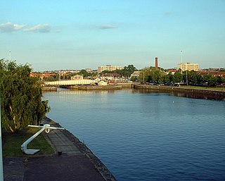
The Cumberland Basin is the main entrance to the docks of the city of Bristol, England. It separates the areas of Hotwells from the tip of Spike Island.

<span class="mw-page-title-main">Jamestown Viaduct</span> Bridge

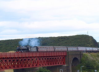
The Jamestown Viaduct is part of the northern approach to the Forth Bridge in Scotland. It crosses the hamlet of Jamestown and the village of North Queensferry in Fife.

<span class="mw-page-title-main">Slateford Aqueduct</span> Bridge in Slateford

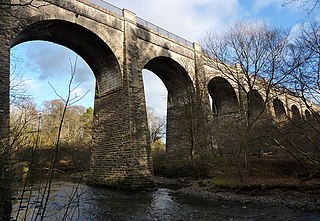
The Slateford Aqueduct is a navigable aqueduct that carries the Union Canal over the Water of Leith at Slateford, Edinburgh, Scotland. Completed in 1822, it has eight arches and spans a length of 500 feet (150 m).

<span class="mw-page-title-main">Avon Aqueduct</span> Bridge in Linlithgow

The Avon Aqueduct is a navigable aqueduct that carries the Union Canal over the River Avon, near Linlithgow, Scotland.

<span class="mw-page-title-main">South Bridge, Edinburgh</span> Bridge in Edinburgh, Scotland, UK

South Bridge is a road bridge and street in Edinburgh, Scotland, between the High Street, where it meets the North Bridge, to Nicolson Street at the south. It forms a continuous roadway over the steep valley scoured parallel to the High Street when the crag and tail landscape of the city was formed. The bridge dips down from the High Street to the Cowgate, which runs under the largest arch of the bridge, before climbing back up to its terminus at Nicolson Street.

<span class="mw-page-title-main">Dean Bridge</span> Bridge in Edinburgh, Scotland

The Dean Bridge spans the Water of Leith in the city of Edinburgh on the A90 road to Queensferry on the Firth of Forth. It carries the roadway, 447 feet (136 m) long and 39 feet (12 m) broad, on four arches rising 106 feet (32 m) above the river. The bridge was one of the last major works before retirement of the bridge designer, civil engineer Thomas Telford, and was completed in 1831 when he was seventy-three years old.

<span class="mw-page-title-main">Caledonian Railway Bridge</span> Bridge

The Caledonian Railway Bridge is a bridge crossing the River Clyde at Broomielaw in Scotland. It is adjacent to Glasgow Central Station.

<span class="mw-page-title-main">Ashton Avenue Bridge</span> Bridge in Bristol, England

The Ashton Avenue Bridge is a pedestrian, cycling and busway bridge in Bristol, England. Grade II listed, it was constructed as a road-rail bridge as part of the Bristol Harbour Railway. It now carries a Bristol MetroBus guided busway route and National Cycle Network cycle routes.

<span class="mw-page-title-main">Forth Bridge</span> Railway bridge over the Firth of Forth in Scotland

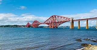
The Forth Bridge is a cantilever railway bridge across the Firth of Forth in the east of Scotland, 9 miles west of central Edinburgh. Completed in 1890, it is considered a symbol of Scotland, and is a UNESCO World Heritage Site. It was designed by English engineers Sir John Fowler and Sir Benjamin Baker. It is sometimes referred to as the Forth Rail Bridge, although this is not its official name.

<span class="mw-page-title-main">Newbattle Viaduct</span> Railway bridge in Midlothian, Scotland, UK

The Newbattle Viaduct, sometimes also called the Lothianbridge, Newtongrange or Dalhousie Viaduct, carries the Borders Railway, which opened in 2015, over the River South Esk near Newtongrange, Midlothian, Scotland.

<span class="mw-page-title-main">Drygrange Old Bridge</span> Bridge

The Drygrange Old Bridge is a disused road bridge over the River Tweed near Melrose in the Scottish Borders.

<span class="mw-page-title-main">Kelso Bridge</span> Bridge

The Kelso Bridge or Rennie's Bridge is a bridge across the River Tweed at Kelso, in the Scottish Borders.

<span class="mw-page-title-main">Trinity Chain Pier</span>

Trinity Chain Pier, originally called Trinity Pier of Suspension, was built in Trinity, Edinburgh, Scotland in 1821. The pier was designed by Samuel Brown, a pioneer of chains and suspension bridges. It was intended to serve ferry traffic on the routes between Edinburgh and the smaller ports around the Firth of Forth, and was built during a time of rapid technological advance. It was well used for its original purpose for less than twenty years before traffic was attracted to newly developed nearby ports, and it was mainly used for most of its life for sea bathing. It was destroyed by a storm in 1898; a building at the shore end survives, much reconstructed, as a pub and restaurant called the Old Chain Pier.

References

  1. 1 2 3 4 5 6 7 8 "Edinburgh, Leith Docks, Victoria Swing Bridge". Canmore . Edinburgh: Royal Commission on the Ancient and Historical Monuments of Scotland . Retrieved 23 September 2014.
  2. "Victoria Swing Bridge, Leith Docks". Listed Buildings. Historic Environment Scotland. 5 September 2014. Retrieved 30 January 2024.
  3. "Audio Trail". The Water of Leith Conservation Trust. Retrieved 30 January 2024.
  4. "Victoria Swing Bridge, Leith". Buildings at Risk Register for Scotland. Historic Environment Scotland. Retrieved 30 January 2024.
  5. "Edinburgh grants listed building consent for Victoria Swing Bridge repairs". Scottish Construction Now. 5 November 2021. Retrieved 30 January 2024.
  6. 1 2 "Victoria Swing Bridge". leithlocalhistorysociety.org.uk. Retrieved 23 September 2014.
  7. "Edinburgh, Leith Docks, Alexandra Dry Dock, Hydraulic Power Station". rcahms.gov.uk. Retrieved 23 September 2014.
  8. 1 2 3 Google (23 September 2014). "Victoria Swing Bridge" (Map). Google Maps . Google. Retrieved 23 September 2014.
  9. "Edinburgh, Leith Docks, Victoria Bridge". rcahms.gov.uk. Retrieved 23 September 2014.