Victoria Tunnel (Newcastle)

Last updated

Victoria Tunnel
Victoria Tunnel (Newcastle) near Ouse Street 2010-02-19.jpg
A lit section of the Victoria Tunnel near the Ouse Street entrance
Overview
Location Newcastle upon Tyne, England
StartTown Moor
End River Tyne
Operation
Work begun1839
Opened7 April 1842 (1842-04-07)
Technical
Length2.25 miles (3.6 km)
Lowest elevation26 meters
Tyne and Wear UK location map.svg
Red pog.svg
Location within Tyne and Wear

The Victoria Tunnel is a subterranean wagonway that runs under Newcastle upon Tyne, England, from the Town Moor down to the River Tyne. It was built between 1839 and 1842 to transport coal from Leazes Main Colliery in Spital Tongues, to riverside staithes (jetties), ready for loading onto boats for export.

Contents

The tunnel was driven through boulder clay, and formed by a base course of stone supporting a brick arch. Loaded wagons descended the incline of the tunnel under their own weight, and were rope-hauled back to the colliery by a stationary engine. The colliery closed in January 1860 and the tunnel was abandoned until the start of the Second World War, when it was converted for use as an air-raid shelter.

The tunnel is 2.4 miles (3.9 km) in length with a maximum depth of 85 feet (26 m) and drops 222 feet (68 m) from entrance to exit. It remains largely intact.

History

Victorian wagonway

When it opened in 1835, the Leazes Main or Spital Tongues colliery was one of many coal mines around Newcastle. The Industrial Revolution demand for coal was high.

Initially, the coal was carried on carts from the colliery through the streets of Newcastle upon Tyne to the river for shipping. This was slow, as the town was largely in a medieval layout, with narrow cobbled streets (Grainger Town was in the early stages of construction) and expensive due to road taxes. Porter and Latimer, the colliery owners, employed a local engineer, William E. Gilhespie, [1] to construct an underground wagonway. [2] An overground wagonway following much the same route was mooted, but the Freemen of Newcastle would not give permission for tracks to be laid across the Town Moor. A more direct route to Elswick, about two miles (3 km) upstream from the mouth of the Ouseburn, was also ruled out, because the old Tyne Bridge prevented ships sailing beyond Newcastle (the Swing Bridge would not be built until 1873). Building a staithe here would require paying the keelmen to take the coal downstream of the bridge before it could be loaded into the colliers, thereby significantly reducing the profit margin on each load of coal shipped.

Construction

Permission to build the tunnel was granted in 1838 and work started the following year. The tunnel was probably dug in sections. The engineers would have excavated a shaft down to the right level then tunneled out to link up with the next section. John Cherry was appointed to manage the tunneling. He was a former Yorkshire Lead Miner who had previously been employed as a miner at the Leazes Main Colliery. Building works were carried out by the firm of David Nixon, a builder of Prudhoe Street, Newcastle upon Tyne. [3] Some 200 workers were employed in the construction of the tunnel and Thomas Fordyce in his Local Records for 8 January 1842 reported:

The workmen, to the number of two hundred, were regaled with a substantial supper and strong ale, supplied by Mrs. Dixon, the worthy hostess of the Unicorn Inn, Bigg-market, Newcastle. The Albion band attended, and enlivened the joyous occasion with their music. [4]

The walls of the tunnel were lined in stone, and a double brick arch supported the roof. It is approximately 7 ft 5 in (2.26 m) high and 6 ft 3 in (1.91 m) wide. This was just large enough to accommodate the custom-built chaldron wagons.

Transporting the coal

Because of the gradual gradient of the tunnel, loaded wagons were able to roll along a standard gauge rail track to the river. A rope was tied to the last wagon in the train and a stationary steam engine at the top of the tunnel hauled the empty wagons back up to the pithead.

Grand opening

The Victoria Tunnel was named after the popular, young Queen Victoria. It was officially opened by the Mayor of Newcastle on 7 April 1842. A crowd of spectators including the sheriff and important merchants gathered on the quayside and at 1 pm cannons were fired as a train of eight wagons appeared out of the tunnel. Four of the wagons contained coal, and the others a "company of ladies and gentlemen and a band of musicians". [5]

Pit closure

The Victoria Tunnel was a financial success: it reduced the cost of transporting coal from the pit to the river by 88%. [6] The colliery, however, was not a success and closed in 1860. [7]

Having taken two and a half years to build, the tunnel was in use for just eighteen years.

Air raid shelter

As Britain prepared for war in 1939, the public were instructed to practise "Air Raid Precautions" to protect themselves from bombs dropped by the German Luftwaffe. In Newcastle, the city engineer developed plans to convert the Victoria Tunnel into a communal air raid shelter that could hold 9,000 people.

Converting the tunnel

Entrance, Claremont Road. Entree Tunnel Victoria Newcastle Tyne 1.jpg
Entrance, Claremont Road.

Converting the tunnel into an air raid shelter cost £37,000. [8] The tunnel was cleaned of coal dust and whitewashed in some places. Several concrete blast walls were added to stop potential bomb debris from entering the tunnel. Electric lighting was fitted and a new concrete floor was laid. Wooden benches and about 500 bunk beds were installed along the walls. Chemical toilets enclosed in canvas cubicles were built near the entrances.

Sixteen new entrances to the tunnel were originally planned, seven of which were added: [2] Claremont Road, Hancock Museum, St Thomas' Churchyard, Ridley Place, Shieldfield Green, Crawhall Road, and Ouse Street. At Ouse Street, it was possible to walk directly into the tunnel, while the other access points looked similar to subway entrances and involved walking down a steep corridor.

Sheltering in the tunnel

The tunnel was considered a dark, damp, and uncomfortable place to shelter. Many people were afraid to use it. Those who did remember sitting with their families and neighbours, sang songs while waiting nervously for the all-clear from above.[ citation needed ]

After the war

At the end of the war, most of the fittings were removed from the tunnel and all of its entrances except Ouse Street were closed. This entrance had been built on private land in the garden of 14 Ouse Street. [9]

Timeline

Route

The Victoria Tunnel originally ran from the site of the Spital Tongues colliery near Hunters Road. It still exists under Claremont Road, and runs past the Hancock Museum, then close to the Civic Centre and St Mary's Place. From here it travels under Northumbria University City Campus, the Central Motorway and Shieldfield to St Dominic's Church on the corner of Crawhall Road and New Bridge Street. It then continues under St Ann's Estate to an entrance on Ouse Street. The section of tunnel that continued from here to the River Tyne was demolished in 1878.

Tunnel statistics

Date opened7 April 1842
Original length2+14 miles (4 km)
Original height7 feet 5 inches (2.26 metres)
Original width6 feet 3 inches (1.91 metres)
Drop222 feet (68 m)
Deepest point85 feet (26 m)
Length accessible today766 yards (700 m)

Restoration

A 766-yard (700 m) section of the tunnel in the Ouseburn Valley is still accessible via a World War II entrance on Ouse Street. A programme of visits was first established by the Ouseburn Partnership in 1998. After a period of closure in 2006, Newcastle City Council carried out a programme of structural repairs and public safety measures, funded by the Heritage Lottery Fund and Tyne & Wear Partnership. The Victoria Tunnel Education Project developed a number of resources about the tunnel and organised public tours and school workshops from 2009. From 2010 the Ouseburn Trust has run guided tours.

A sound and light installation, commissioned from artist Adinda van 't Klooster, focuses on the themes of war, fear, and nuclear weapons, using the codenames of British military research projects as a backdrop.

Related Research Articles

<span class="mw-page-title-main">Blaydon</span> Human settlement in England

Blaydon is a town in the Metropolitan Borough of Gateshead, Tyne and Wear, England, and historically in County Durham. Blaydon, and neighbouring Winlaton, which Blaydon is now contiguous with, form the town of Blaydon-on-Tyne. The Blaydon/Winlaton ward had a population in 2011 of 13,896.

<span class="mw-page-title-main">Bowes Railway</span> British preserved standard gauge cable railway system (built 1826)

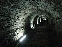
The Bowes Railway, built by George Stephenson in 1826, is the world's only operational preserved standard gauge cable railway system. It was built to transport coal from pits in Durham to boats on the River Tyne. The site is a scheduled monument. The railway is open every week on Thursday, Friday and Saturday as well as on a number of event days throughout the year.

<span class="mw-page-title-main">North Tyneside Steam Railway</span> Visitor attraction in North East England

The North Tyneside Steam Railway and Stephenson Steam Railway are visitor attractions in North Shields, North East England. The museum and railway workshops share a building on Middle Engine Lane adjacent to the Silverlink Retail Park. The railway is a standard gauge line, running south for 2 miles (3.2 km) from the museum to Percy Main. The railway is operated by the North Tyneside Steam Railway Association (NTSRA). The museum is managed by Tyne and Wear Archives and Museums on behalf of North Tyneside Council.

<span class="mw-page-title-main">History of Newcastle upon Tyne</span> Development of a city in North East England

The history of Newcastle upon Tyne dates back almost 2,000 years, during which it has been controlled by the Romans, the Angles and the Norsemen amongst others. Newcastle upon Tyne was originally known by its Roman name Pons Aelius. The name "Newcastle" has been used since the Norman conquest of England. Due to its prime location on the River Tyne, the town developed greatly during the Middle Ages and it was to play a major role in the Industrial Revolution, being granted city status in 1882. Today, the city is a major retail, commercial and cultural centre.

<span class="mw-page-title-main">Newburn</span> Human settlement in England

Newburn is a village and district of Newcastle upon Tyne, in Tyne and Wear, England. Situated on the North bank of the River Tyne, it is built rising up the valley from the river. It is situated approximately 5 miles (8 km) from the city centre, 14 miles (23 km) east of Hexham and 13 miles (21 km) south south west of Morpeth. In the 2001 census, the population was given as 9,301, increasing to 9,536 at the 2011 Census. Newburn is in the Newcastle upon Tyne district of Tyne and Wear and is part of the parliamentary constituency of Newcastle upon Tyne North.

<span class="mw-page-title-main">Fawdon</span> Human settlement in England

Fawdon is an electoral ward of Newcastle upon Tyne, in the county of Tyne and Wear, England. It is also close to the A1 western bypass. The population of the ward is 10,890, reducing to 10,090 at the 2011 Census, 5.7% of the total population of Newcastle upon Tyne. Car ownership in the area is 53.6%, lower than the city average of 54.7%. Until 1974 it was in Northumberland.

<span class="mw-page-title-main">Byker</span> Human settlement in England

Byker is a district in the east of the city and metropolitan borough of Newcastle upon Tyne, in the county of Tyne and Wear, England. Home to the Byker Wall estate, made famous by TV series Byker Grove, Byker's population was recorded at 12,206 in the 2011 census. Byker is bordered by Heaton to the north and by Shieldfield to the north east. Until 1974 it was in Northumberland.

Hazlerigg is a village and civil parish north of the City of Newcastle upon Tyne in Tyne and Wear, England. It is about 5 miles (8.0 km) north of the city centre, on the A1. It is split between Newcastle upon Tyne and North Tyneside, each side of the A1 being a different district. The parish council administer the Newcastle side, whereas the area located in North Tyneside is unparished. Much of the Newcastle Great Park development is within the area administered by the Hazlerigg Parish Council. Located in the village is a post office, a fish & chip shop, a beauty salon, a hairdresser, a garage, a convenience store and a social club that is now open under new management. In spite of having a population of 1,053, and almost 800 homes, Hazlerigg has never had a pub. The population of the civil Parish taken at the 2011 Census was 980.

<span class="mw-page-title-main">Ouseburn</span> River in Newcastle upon Tyne, England

The Ouseburn is a small river in Newcastle upon Tyne, England that flows through the city into the River Tyne. It gives its name to the Ouseburn Valley and the Ouseburn electoral ward for Newcastle City Council elections.

<span class="mw-page-title-main">Seaton Sluice</span> Human settlement in England

Seaton Sluice is a village in Northumberland. It lies on the coast at the mouth of the Seaton Burn, midway between Whitley Bay and Blyth. In the 2021 census the village had a population of 2,956.

<span class="mw-page-title-main">Spital Tongues</span> District of Newcastle upon Tyne, England

Spital Tongues is a district of Newcastle upon Tyne, located due north-west of the Newcastle City Centre. Its unusual name is believed to be derived from spital – a corruption of the word hospital, commonly found in British place names - and tongues, meaning outlying pieces of land. North of Spital Tongues is Leazes Park and the Town Moor.

The Ouseburn Valley is the name of the valley of the Ouseburn, a small tributary of the River Tyne, running southwards through the east of Newcastle upon Tyne, England. The name refers particularly to the urbanised lower valley, spanned by three impressive bridges, which is nowadays a cultural and social oasis close to the centre of Newcastle.

<span class="mw-page-title-main">Royal Victoria Infirmary</span> Hospital in Newcastle, England

The Royal Victoria Infirmary (RVI) is a 673-bed tertiary referral hospital and research centre in Newcastle upon Tyne, England, with strong links to Newcastle University. The hospital is part of the Newcastle upon Tyne Hospitals NHS Foundation Trust and is a designated academic health science centre.

<span class="mw-page-title-main">Collier (ship)</span> Bulk cargo ship to carry coal

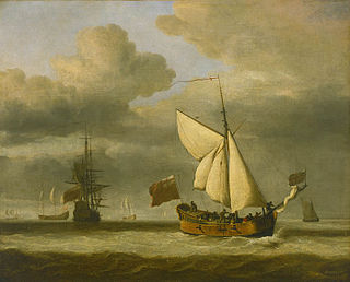
A collier is a bulk cargo ship designed or used to carry coal. Early evidence of coal being transported by sea includes use of coal in London in 1306. In the fourteenth and fifteenth centuries, coal was shipped from the River Tyne to London and other destinations. Other ports also exported coal – for instance the Old Quay in Whitehaven harbour was built in 1634 for the loading of coal. London became highly reliant on the delivery of coal by sea – Samuel Pepys expressed concern in the winter of 1666–67 that war with the Dutch would prevent a fleet of 200 colliers getting through. In 1795, 4,395 cargoes of coal were delivered to London. By 1824, this number had risen to about 7,000; by 1839, it was over 9,000. The trade continued to the end of the twentieth century, with the last cargo of coal leaving the Port of Tyne in February, 2021.

<span class="mw-page-title-main">Newcastle City Centre</span> City centre of Newcastle upon Tyne, England

Newcastle City Centre is the city centre district of Newcastle upon Tyne, England. It is the historical heart of the city and serves as the main cultural and commercial centre of the North East England region. The city centre forms the core of the Tyneside conurbation.

Seaton Burn is a village in North Tyneside, Tyne and Wear, to the north of Newcastle upon Tyne, and adjacent to Wideopen which is just south of it. It is part of the wider Seaton valley in which some Seaton villages are in Northumberland, and others in North Tyneside, Tyne and Wear. This is because the area lies on the border between the two counties.

Derwenthaugh Coke Works was a coking plant on the River Derwent near Swalwell in Gateshead. The works were built in 1928 on the site of the Crowley's Iron Works, which had at one time been the largest iron works in Europe. The coke works was closed and demolished in the late 1980s, and replaced by Derwenthaugh Park.

<span class="mw-page-title-main">Fawdon Wagonway</span>

The Fawdon Wagonway was from 1818 to 1826 a 1 mile 3 furlongs (2.2 km) long horse-drawn and partially rope-operated industrial railway in Fawdon near Newcastle upon Tyne. It was the first cable car employing a moving rope that could be picked up or released by a grip on the cars.

<span class="mw-page-title-main">Seaton Burn Wagonway</span> Cable railway near Newcastle upon Tyne, England

The Seaton Burn Wagonway was from 1826 to 1920 a partially horse-drawn and partially rope-operated industrial railway with a gauge of 4 ft 6 in near Newcastle upon Tyne.

<span class="mw-page-title-main">Monument, Newcastle upon Tyne</span> Ward in England

Monument is an electoral ward and area of Newcastle upon Tyne. It was established as an electoral ward in 2018. It takes its name from Grey's Monument. It replaced most of Westgate ward, parts of South Jesmond and some of Ouseburn.

References

  1. Tingle, Rory (24 February 2017). "Newcastle Victoria Tunnel: Take a tour of the tunnel 85ft beneath the city's streets". ChronicleLive. Newcastle upon Tyne, UK.
  2. 1 2 3 Graham, Hannah (11 February 2017). "How the Victoria Tunnel saved Geordies from WW2 bombs". ChronicleLive. Newcastle upon Tyne, UK.
  3. "The Spital Tongues Tunnel". The Monthly Chronicle of North-Country Lore and Legend (September 1887): 302.
  4. Fordyce, Thomas (1867). "8 January 1842". Local Records. 3.
  5. Richardson, Moses Aaron (1846). "1842 April 7". The Local Historian's Table Book. V.
  6. Thirkell, Phil (April 2006). "Home". victoriatunnel.info.
  7. 1 2 "Victoria Tunnel: The unknown relic hidden under the city". BBC News. 7 June 2013.
  8. Rowe, D.J. (1971). "The Victoria Tunnel". Industrial Archaeology: The Journal of the History of Industry and Technology. 7.
  9. "Ouseburn Trust". Ouseburn Trust. Retrieved 9 September 2017.

Further reading