Village Statistics, 1945

Last updated
Map of Palestine cultivated land ownership by sub-district (1945), in french "Reparatition de la propriete agraire", originally published in the Village Statistics, 1945 Palestine Land ownership by sub-district (1945).jpg
Map of Palestine cultivated land ownership by sub-district (1945), in french "Réparatition de la propriété agraire", originally published in the Village Statistics, 1945

Village Statistics, 1945 was a joint survey work prepared by the Government Office of Statistics and the Department of Lands of the British Mandate Government for the Anglo-American Committee of Inquiry on Palestine which acted in early 1946. [1] The data were calculated as of April 1, 1945, [2] and was later published and also served the UNSCOP committee that operated in 1947.

Contents

History

Previous versions of the report were prepared in 1938 and 1943. [3]

The report found the grand total of the population of Palestine was 1,764,520; 1,061,270 Muslims, 553,600 Jews, 135,550 Christians and 14,100 classified as "others" (typically Druze). [4]

Regarding the accuracy of its statistics, the report said:

The last population census taken in Palestine was that of 1931. Since that year, the population has grown considerably both as a consequence of Jewish immigration and of the high rate of natural increase among all sections of the population. The rapidity of the change in the size of the population and the length of the period elapsed since the census rendered difficult the task of estimating the population. The population estimates published here are the result of a very detailed work conducted by the Department of Statistics, by using all the statistical material available on the subject. They cannot, however, be considered as other than rough estimates which in some instances may ultimately be found to differ even considerably, from the actual figures. The estimates for the whole of Palestine are to be considered as more reliable than those for sub-districts, while the sub-district estimates can, in turn, be considered as more reliable than those of the individual localities. [5]

Population statistics were prepared in four stages. [5]

  1. The settled population for the whole of Palestine was estimated using the 1931 census data together with natural increase and recorded immigration. Unrecorded immigration of Jews was estimated using data from ships arriving, arrests, and data prepared by the Jewish Agency. Unrecorded immigration or emigration of Arabs could not be estimated "but these movements are not considered to be such as to involve very substantial errors".
  2. An initial population estimate for each sub-district was prepared from the 1931 census and natural increase, plus an allotment from the migratory increase. Then several methods were used to adjust the relative population of different sub-districts using calculations of natality, mortality and fertility in each sub-district.
  3. The settled population for each locality was provisionally estimated using several previous estimates made up to 1944. Then an overall adjustment was made to bring the total for each sub-district up to the sub-district population estimated at the previous step.
  4. The nomadic population estimated at the 1931 census was used since no reliable records for the changes were available.

Regarding the figures for land ownership, the report said: "The areas and ownership have been extracted from the Tax Distribution Lists, prepared under the provisions of the Rural Property Tax Ordinance, 1942, the Valuation Lists prepared under the Urban Property Tax Ordinance, 1940, and the Commuted Tithe records for Beersheba Sub-District, in the Gaza District." [5]

Israeli geographer Moshe Brawer noted that the report was "an important if not the foremost source of information on population, land possession and land utilization" but questioned its accuracy on several grounds. [6] For example, he wrote that aerial photographs showed the population of some localities to be exaggerated, and that land use classifications may have been biased towards categories that attracted lower taxes. [6]

See also

Related Research Articles

Nimrin Place in Tiberias, Mandatory Palestine

Nimrin was a Palestinian Arab town of 320 that was captured and depopulated by Israel during the 1948 Arab-Israeli War.

Islin Place in Jerusalem, Mandatory Palestine

Islin was a Palestinian Arab village located 21 kilometers west of Jerusalem. The village had a population of 302 inhabitants and was depopulated during the 1948 Arab-Israeli war. It was occupied by Israeli forces, possibly from the Fourth Battalion of the Harel Brigade, on 18 July 1948 during Operation Dani, causing its inhabitants to leave. Eshtaol, a moshav, was built on the village's land.

Tabsur Village in Tulkarm, Mandatory Palestine

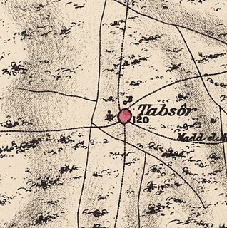
Tabsur, also Khirbat 'Azzun, was a Palestinian village located 19 kilometres southwest of Tulkarm. In 1931, the village had 218 houses and an elementary school for boys. Its Palestinian population was kicked out during the 1948 Arab-Israeli war.

Qabalan Municipality type C in Nablus, State of Palestine

Qabalan is a Palestinian town in the Nablus Governorate in the eastern West Bank, located 19 kilometers (12 mi) southeast of Nablus. According to the Palestinian Central Bureau of Statistics (PCBS), the town had a population of 7,130 inhabitants in 2007.

Mirka is a Palestinian village in the West Bank, located 12 km (7.5 mi) Southwest of the city of Jenin in the northern West Bank. According to the Palestinian Central Bureau of Statistics, the town had a population of 1,555 inhabitants in mid-year 2006.

Kur, Tulkarm Municipality type D in Tulkarm, State of Palestine

Kur is a Palestinian village in the Tulkarm Governorate in the eastern West Bank, located 19 kilometers South-east of Tulkarm.

Idnibba Place in Ramle, Mandatory Palestine

Idnibba was a Palestinian village, located at latitude 31.7426937N and longitude 34.8561001,E in the southern part of the Ramle Subdistrict. It was depopulated in 1948, at which time its population was 568, and its lands are now used by Kfar Menahem.

Naghnaghiya Village in Haifa, Mandatory Palestine

Naghnaghiya was a Palestinian Arab village, 28.5 kilometers (17.7 mi) southeast of Haifa. It was depopulated before the outbreak of the 1948 Arab-Israeli war.

Arab al-Safa Village in Baysan, Mandatory Palestine

Arab al-Safa, was a Palestinian Arab village in the District of Baysan. It was depopulated during the 1948 Arab-Israeli War. It was located 7.5 km south of Baysan.

Al-Fatur Place in Baysan, Mandatory Palestine

Al-Fatur was a Palestinian Arab village in the District of Baysan. It was depopulated during the 1947–1948 Civil War in Mandatory Palestine on May 12, 1948. It was located 11.5 km south of Baysan. The village was attacked by the Israel Defense Forces as part of Operation Gideon.

Masil al-Jizl Village in Baysan, Mandatory Palestine

Masil al-Jizl was a Palestinian Arab village in the District of Baysan. It was depopulated by the Israel Defense Forces during the Arab-Israeli War. It was attacked and depopulated on May 31, 1948, as part of Operation Gideon.

Bayt Affa Place in Gaza, Mandatory Palestine

Bayt 'Affa was a Palestinian village in the Gaza Subdistrict. It was depopulated and destroyed during the 1947–48 Civil War in Mandatory Palestine. It was located 29 km (18 mi) northeast of Gaza and Wadi al-Rana ran east of the village.

Al-Ghubayya al-Fawqa Village in Haifa, Mandatory Palestine

Al-Ghubayya al-Fawqa was a Palestinian Arab village in the Haifa Subdistrict. It was depopulated during the 1947–48 Civil War in Mandatory Palestine on April 8, 1948, during the Battle of Mishmar HaEmek. It was located 28 km southeast of Haifa.

Al-Jammasin al-Sharqi Village in Jaffa, Mandatory Palestine

Al-Jammasin al-Sharqi was a Palestinian Arab village in the Jaffa Subdistrict. It was depopulated during the 1948 Palestine War on March 17, 1948. It was located 9 km northeast of Jaffa.

Bayt Shanna Village in Ramle, Mandatory Palestine

Bayt Shanna was a Palestinian Arab village in the Ramle Subdistrict of Mandatory Palestine. It was depopulated during the 1948 Arab–Israeli War on July 15, 1948, during the second stage of Operation Dani. It was located 11.5 km southeast of Ramla.

Jilya Village in Ramle, Mandatory Palestine

Jilya was a Palestinian Arab village in the Ramle Subdistrict of Mandatory Palestine. The Romans referred to it as Jilya by Galla. It was depopulated during the 1948 Arab–Israeli War by the Givati Brigade of the first stage of Operation Dani on July 9, 1948. It was located 17 km south of Ramla.

Fara, Safad Village in Safad, Mandatory Palestine

Fara was a Palestinian Arab village in the Safad Subdistrict. It was depopulated during the 1948 Arab-Israeli War on October 30, 1948, under Operation Hiram. It was located 11.5 km north of Safad on the Wadi al-Fara.

Qabbaa Village in Safad, Mandatory Palestine

Qabba'a was a Palestinian Arab village in the District of Safad. It was depopulated during the 1948 War on May 26, 1948, by the Palmach's First Battalion of Operation Yiftach. It was located 6 km northeast of Safad.

Al-Ulmaniyya Village in Safad, Mandatory Palestine

Al-'Ulmaniyya was a Palestinian Arab village in the Safad Subdistrict. It was depopulated during the 1947–1948 Civil War in Mandatory Palestine on April 20, 1948, by the Palmach's First Battalion of Operation Yiftach. It was located 14.5 km northeast of Safad.

Madama, Nablus Municipality type C in Nablus, State of Palestine

Madama is a Palestinian village in the Nablus Governorate.

References

  1. Hadawi, S., Village statistics, 1945, A Classification of Land and Area Ownership in Palestine, pp. 11-12
  2. ורד בר-און, שימוש בתוכנות מחשב ככלי עזר בניתוח גאוגרפי היסטורי בהדגמה על "סקר הכפרים" (1945), עמ' III
  3. Finkelstein, I. (1990). "A Few Notes on Demographic Data from Recent Generations and Ethnoarchaeology". Palestine Exploration Quarterly . 122: 47–52. doi:10.1179/peq.1990.122.1.47.
  4. Department of Statistics, 1945, p. 3
  5. 1 2 3 Government of Palestine, Village Statistics 1945. Explanatory Note p. 2.
  6. 1 2 Brawer, M. (1994-12-01). "All that remains?". Israel Affairs. 1 (2): 334–345. doi:10.1080/13537129408719331. ISSN   1353-7121.