Virudhunagar district

Last updated

Virudhunagar district
Award City
Nickname: 
Virudhai
Virudhunagar district
Location in Tamil Nadu
Coordinates: 9°36′N78°00′E / 9.6°N 78°E / 9.6; 78
CountryFlag of India.svg  India
State TamilNadu Logo.svg Tamil Nadu
Taluks10
Panchayat Unions (Blocks)11
Corporation1
Municipalities6
Established15 March 1985
Administrative headquarters Virudhunagar
Talukas Aruppukkottai, Kariapatti, Rajapalayam, Sattur, Sivakasi, Srivilliputhur, Tiruchuli, Vembakottai, Virudhunagar, Watrap
Government
  CollectorDr. V P Jeyaseelan IAS
  Superintendent of PoliceThiru. Srinivasa Perumal, M.A., M.B.A, IPS
Area
  Total4,288 km2 (1,656 sq mi)
  Rank13
Highest elevation
187 m (614 ft)
Lowest elevation
69 m (226 ft)
Population
 (2011)
  Total1,942,288
  Rank15 (Tamilnadu)
  Density450/km2 (1,200/sq mi)
Languages
  Official Tamil
Time zone UTC+5:30 (IST)
PIN
626xxx
Telephone code04562
ISO 3166 code [[ISO 3166-2:IN|]]
Vehicle registration TN 67(Virudhunagar), TN 84(Srivilliputtur) TN 67W(Aruppukottai), TN 95(Sivakasi)
Central location: 9°35′N77°57′E / 9.583°N 77.950°E / 9.583; 77.950
Website virudhunagar.nic.in

Virudhunagar District is a district (an administrative district) of Tamil Nadu state in south India. Virudhunagar is the district headquarters of Virudhunagar district. Virudhunagar district was formed by the separation of Old Ramanathapuram District G.O passed on 08,March 1985 & formed in 15,March 1985 into Ramanathapuram District, Sivagangai District and the west part as Virudhunagar District. Virudhunagar District was formerly called Karmavirer Kamarajar District. As of 2011, Virudhunagar district had a population of 1,942,288 with a sex-ratio of 1,007 females for every 1,000 males. Sivakasi is the most populous and largest city in the district.

Contents

Demographics

Historical population
YearPop.±% p.a.
1901584,278    
1911654,862+1.15%
1921691,149+0.54%
1931739,064+0.67%
1941768,137+0.39%
1951859,840+1.13%
1961972,288+1.24%
19711,151,449+1.71%
19811,340,907+1.53%
19911,565,037+1.56%
20011,751,301+1.13%
20111,942,288+1.04%
source: [1]
Religions in Virudhunagar district (2011) [2]
ReligionPercent
Hinduism
93.84%
Christianity
3.47%
Islam
2.46%
Other or not stated
0.23%

According to 2011 census, Virudhunagar district had a population of 1,942,288, [3] up from 1,751,301 in 2001, [4] or about an 11% increase. The sex-ratio was 1,007 females for every 1,000 males, much above the national average of 929, [3] but down from 1,012 in 2001. [4] A total of 197,134 were under the age of six, constituting 100,827 males and 96,307 females. Scheduled Castes and Scheduled Tribes accounted for 20.59% and 0.12% of the population, respectively. The average literacy of the district was 72.02%, compared to the national average of 72.99%. [3] The district had a total of 537,748 households. There were a total of 950,158 workers, comprising 52,361 cultivators, 168,174 main agricultural labourers, 30,292 in house hold industries, 603,239 other workers, 96,092 marginal workers, 4,792 marginal cultivators, 40,528 marginal agricultural labourers, 5,006 marginal workers in household industries and 45,766 other marginal workers. [3]

Languages of Virudhunagar district (2011) [5]

   Tamil (89.51%)
   Telugu (8.87%)
   Kannada (1.35%)
  Others (0.27%)

At the time of the 2011 census, 89.51% of the population spoke Tamil, 8.87% Telugu and 1.35% Kannada as their first language. [5]

Location

River Basins in Virudhunagar district. Dark green shaded region shows the drainage basins. River Basins in Virudhunagar District.png
River Basins in Virudhunagar district. Dark green shaded region shows the drainage basins.
Relief map of Virudhunagar district. Western Ghats appear left hand side as brightly shaded region. Relief Features in Virudhunagar District.png
Relief map of Virudhunagar district. Western Ghats appear left hand side as brightly shaded region.

The district is bounded by Sivagangai district and Madurai district on the north, Tenkasi district and Tuticorin District to the south and Ramanathapuram District on east Theni district to the northwest and Idukki district of Kerala to the west.

Politics

Source: [6] [7]
DistrictNo.ConstituencyNamePartyAllianceRemarks
Virudhunagar 202 Rajapalayam S. Thangappandian Dravida Munnetra Kazhagam SPA
203 Srivilliputhur (SC) E. M. Manraj All India Anna Dravida Munnetra Kazhagam None
204 Sattur A. R. R. Raghumaran Dravida Munnetra Kazhagam (MDMK) SPA
205 Sivakasi A. M. S. G. Ashokan Indian National Congress SPA
206 Virudhunagar A. R. R. Seenivasan Dravida Munnetra Kazhagam SPA
207 Aruppukkottai K. K. S. S. R. Ramachandran Dravida Munnetra Kazhagam SPA
208 Tiruchuli Thangam Thennarasu Dravida Munnetra Kazhagam SPA

Administration

The district is divided into three revenue divisions - Sivakasi, Sattur and Aruppukottai.

The district comprises ten taluks: Aruppukkottai, Kariapatti, Rajapalayam, Sattur, Sivakasi, Srivilliputhur, Tiruchuli, Vembakottai, Virudhunagar and Watrap. [8] In total there are 600 revenue villages in this district.

This district has nine town panchayats – Seithur, Vathirairuppu, Chettiarpatti, Kariapatti, Mamsapuram, Sundarapandiam, Mallankinaru, S.Kodikulam and W.Pudupatti.

The Parliamentary Constituency number of Virudhunagar District is 34.

Economy

Virudhunagar district is leading in the country in the match industry, fireworks and printing, mostly concentrated in and around Sivakasi.[ citation needed ] Virudhunagar is the main market for oil, chicory, coffee seeds, dry chillies and pulses.[ citation needed ] There are two trade centres (Godowns) in the District one in Virudhunagar and another in Rajapalayam. Ginning factories, spinning mills, power loom and hand loom industries are also present in the district at Rajapalayam the second big weaving town in the state after Coimbatore.[ citation needed ] One of the cement plants of Ramco Cements Ltd is located in RR Nagar [9] near Viudhunagar another one located at Alankulam of Sivakasi Taluk.[ citation needed ]. In 2018, Government of India classifies Virudhunagar as one of the 112 most underdeveloped district across the country and brought it under Aspirational Districts Programme Phase 1. [10]

See also

Related Research Articles

<span class="mw-page-title-main">Aruppukkottai</span> City in Tamil Nadu, India

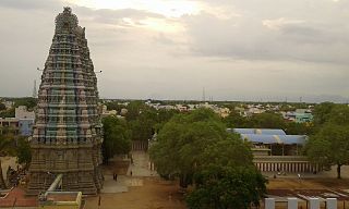
Aruppukottai is a city and a municipality in Virudhunagar district in the state of Tamil Nadu, India. Aruppukottai's classical name is "Sengattu Aravakotai". Aruppukottai is about 50 km from Madurai. It is in the middle of Madurai-Tuticorin National Highways NH-38. The villages and towns surrounding Aruppukottai makes this as a major city as well as a major transit hub and they are also famous for production of jasmine. Aruppukottai is always famous for producing yarn. Sri Ramana Maharishi was born in Tiruchuli near Aruppukottai town. Aruppukottai was part of king Sethupathi of Ramnad. King Sethupathi has Zamin Palace in Palyampatti. As of 2011, the town had a population of 2,00,000. The town also hosts two famous temples – Arulmigu Meenakshi Chokkanatha Swamy Temple built in 13th century by Pandiya King Maravarma Sundarapandiyan and Seenivasa Perumal Temple Built on the top of Malai arasan Hill.

<span class="mw-page-title-main">Sivakasi</span> City and municipal corporation in Tamil Nadu, India

Sivakasi is a city in Virudhunagar District in the Indian state of Tamil Nadu. The city is known for firecrackers and match factories that produce 70% of the country's produce. The printing industries in Sivakasi produce 30% of the total diaries produced in India. The industries in Sivakasi employ over 25,000 people and the estimated turnover of the firecracker, match making and printing industries in the city is around 20 billion (US$250 million). The major issues in the city are the frequent accidents in the firecracker factories and the high level of child labour.

<span class="mw-page-title-main">Sivaganga</span> Municipality in Tamil Nadu, India

Sivaganga is a City and headquarters of the Sivaganga district in the Indian state of Tamil Nadu.

<span class="mw-page-title-main">Virudhunagar</span> City in Tamil Nadu, India

Virudhunagar is a city and the administrative headquarter of the Virudhunagar district in the Indian state of Tamil Nadu. It is located 506 km (314 mi) southwest of the state capital Chennai and 53 km (33 mi) south of Madurai. Virudhunagar emerged as an important trade centre during the British rule. Located to the east of Kowsika River, Virudhunagar has an average elevation of 102 m (335 ft) above sea level and is largely flat with no major geological formations. The town has a humid climate and receives 780 mm (31 in) rainfall annually. It has been ruled at various times by Later Pandyas, Vijayanagar Empire, Madurai Nayaks, Chanda Sahib, Carnatic kingdom and the British. It was formerly known as Virudhupatti.

<span class="mw-page-title-main">Rajapalayam</span> Town in Tamil Nadu, India

Rajapalayam is a town in the Indian state of Tamil Nadu. It is the largest municipality in the Virudhunagar district. Rajapalayam is located on the Madurai to Quilon National Highway at a distance of 562 km south of the state capital Chennai. The economy is primarily industrial with several mills for spinning and weaving. The town is known for its mango and the Rajapalayam breed of dogs.

Sattur or Saathur is a town in Virudhunagar district in the Indian state of Tamil Nadu. As of 2011, the town had a population of 29,398.

<span class="mw-page-title-main">Vellore district</span> District of Tamil Nadu in India

Vellore district is one of the 38 districts in the Tamil Nadu state of India. It is one of the eleven districts that form the north region of Tamil Nadu. Vellore city is the headquarters of this district. As of 2011, the district had a population of 1,614,242 with a sex ratio of 1,007 females for every 1,000 males. In 2017 Vellore district ranked eleventh in list of districts in Tamil Nadu by Human Development Index.

<span class="mw-page-title-main">Melur</span> Municipality in Tamil Nadu, India

Melur is the Northern entrance of Madurai district. It is the town and municipality in the Madurai North in the Indian state of Tamil Nadu. Melur Old Name is Called Naduvi Nadu. The name Melur name comes from "Mela Nadu". Melur is called Thaigramam. It is the biggest taluk within the Madurai District. As of 2011, the town had a population of 40,017. Melur is an agricultural land in Madurai and the climate around the area is tropical.

Paramakudi or Paramagudi is the largest town in the district of Ramanathapuram in Tamil Nadu, India, with a population of over 95,579. It has been the taluk headquarters since the formation of Ramanathapuram District in 1918.

<span class="mw-page-title-main">Ramanathapuram district</span> District of Tamil Nadu in India

Ramanathapuram District, also known as Ramnad District, is one of the 38 districts an administrative districts of Tamil Nadu state in southern India. The old Ramanathapuram District consists of Present day Virudhunagar and Sivagangai districts, it touches the Western ghats and bordered with the state of Kerala and east by Bay of Bengal. It was the largest district on that time. The town of Ramanathapuram is the district headquarters. Ramanthapuram District has an area of 4,123 km2. It is bounded on the north by Sivaganga District, on the northeast by Pudukkottai District, on the east by the Palk Strait, on the south by the Gulf of Mannar, on the west by Thoothukudi District, and on the northwest by Virudhunagar District. The district contains the Pamban Bridge, an east–west chain of low islands and shallow reefs that extend between India and the island nation of Sri Lanka, and separate the Palk Strait from the Gulf of Mannar. The Palk Strait is navigable only by shallow-draft vessels. As of 2011, Ramanathapuram district had a population of 1,353,445 with a sex-ratio of 983 females for every 1,000 males. The district is home to the pilgrimage center of Rameswaram and tourist spot Dhanushkodi, an abandoned town.

<span class="mw-page-title-main">Thoothukudi district</span> District of Tamil Nadu in India

Thoothukudi District is one of the 38 districts of Tamil Nadu state in southern India. The district was formed by bifurcation of Tirunelveli district on 20 October 1986. Thoothukudi is the district headquarters and largest city of the district. The district is known for fishing as well as pearl cultivation, with an abundance of pearls being found in the seas offshore. Thoothukudi district has many historical sites such as Adichanallur and the ancient trade port of Korkai.

<span class="mw-page-title-main">Tiruchirappalli district</span> District of Tamil Nadu in India

Tiruchirappalli District is one of the 38 districts, located along the Kaveri River, in Tamil Nadu, India. The headquarters of the district is the city of Tiruchirappalli.

<span class="mw-page-title-main">Sivaganga district</span> Place in Tamil Nadu, India

Sivaganga District is one of the 38 districts in Tamil Nadu state, India. This district was formed on 15 March 1985 by trifurcation of Ramanathapuram district into Ramanathapuram, Virudhunagar and Sivagangai districts. Sivaganga is the district headquarters. Karaikudi is the most populous Town as well as City Corporation in the district. It is bounded by Pudukkottai district on the Northeast, Tiruchirapalli district on the North, Ramanathapuram district on South East, Virudhunagar district on South West and Madurai District on the West. The area's other larger towns include Sivagangai, Kalayar Kovil, Devakottai, Manamadurai, ilayangudi, Thiruppuvanam, Singampunari and Tiruppattur. As of 2011, the district had a population of 1,339,101 with a sex ratio of 1,003 females for every 1,000 males.

<span class="mw-page-title-main">Pudukkottai district</span> District in Tamil Nadu, India

Pudukkottai District is one of the 38 districts of Tamil Nadu state in southern India. The city of Pudukkottai is the district headquarters. It is also known colloquially as Pudhugai.

<span class="mw-page-title-main">Dindigul district</span> District of Tamil Nadu in India

Dindigul District is one of the 38 districts in the state of Tamil Nadu in India. Dindigul District is the largest district in Tamil Nadu by area. The district was carved out of Madurai District in 1985. It has an area of 6266.64 km2 and comprises 3 revenue divisions, 10 taluks, and 14 panchayat unions. The district is located in Southwest of Tamil Nadu. The district is bound by Madurai district in the south,Tiruppur district in the northwest, Karur district in the north, Tiruchirappalli district in the northeast, Theni district in the Southwest and Idukki district of Kerala to the west. As of 2011, the district had a population of 2,159,775 with a sex-ratio of 998 females for every 1,000 males.

<span class="mw-page-title-main">Perambalur</span> Selection Grade Municipality in Tamil Nadu, India

Perambalur is a town in the Indian state of Tamil Nadu. It is the headquarters of Perambalur district and Perambalur taluk (sub-district). As of 2011 census, the town had a population of 49,648.

Sankarankovil is a Town in the Tenkasi district in the Indian state of Tamil Nadu. It was formerly known as Sankaranayinarkoil. Sankarankovil is the home to the Sankara Narayanar Temple.

Katthivakkam is an residential and industrial area located in the northern part of Chennai. It is a part of zone 1 in Greater Chennai Corporation. It is under Thiruvottiyur taluk in Chennai district. It is a part of Thiruvottiyur(state assembly constituency) and Chennai North. Formerly a town and a municipality of Thiruvallur district in the Indian state of Tamil Nadu, it has now been absorbed by Chennai city in September 2011 and within Chennai District limit since January 2018. The neighbourhood is served by Katthivakkam railway station. As of 2011, the town had a population of 36,617.

<span class="mw-page-title-main">Tiruvarur district</span> District of Tamil Nadu in India

Thiruvarur district is one of the 38 districts in the Tamil Nadu state of India. As of 2011, the district had a population of 1,264,277 with a sex-ratio of 1,017 females for every 1,000 males.

Karaiyippatti is a town and a municipality in the Madurai district in the Indian state of Tamil Nadu. Karaiyippatti is called Thaikramam. It is the biggest taluk within the Madurai District.

References

  1. Decadal Variation In Population Since 1901
  2. "Table C-01 Population by Religion: Tamil Nadu". censusindia.gov.in. Registrar General and Census Commissioner of India. 2011.
  3. 1 2 3 4 "District Census Handbook 2011 - Virudhunagar" (PDF). Census of India . Registrar General and Census Commissioner of India.
  4. 1 2 "Census of India 2001: Basic Data Sheet: District Virudhunagar" (PDF). Registrar General & Census Commissioner, India. Archived (PDF) from the original on 25 September 2012.
  5. 1 2 "Table C-16 Population by Mother Tongue: Tamil Nadu". Census of India . Registrar General and Census Commissioner of India.
  6. "Tamil Nadu Election Results 2021: Here's full list of winners". CNBCTV18. 3 May 2021. Retrieved 22 December 2023.
  7. "Tamil Nadu Election Results 2021: Full list of winners". www.indiatvnews.com. 2 May 2021. Retrieved 22 December 2023.
  8. "NPR Report: Tamil Nadu: Virudhunagar". National Population Register, Ministry of Home Affairs, Government of India. 2011. Archived from the original on 16 July 2014.
  9. "Cements | India Cements | Ramco Cements | Cement | Best Cement in India | | Cements share price | Cements of India | Cement of India | Good Cement | Cement manufacturing company India | Cement Company | Cement manufacture | Indian Cement". ramcocements.in. Retrieved 15 July 2020.
  10. "Aspirational Districts Programme | NITI Aayog". www.niti.gov.in. Retrieved 28 September 2023.