Vulcan, Alberta

Last updated

Vulcan
Town
Town of Vulcan
Vulcan visitor centre 2013.JPG
Tourism and Trek Station
Alberta County Point Locator.svg
Red pog.svg
Vulcan
Location of Vulcan
Canada location map 2.svg
Red pog.svg
Vulcan
Vulcan (Canada)
Coordinates: 50°24′24″N113°15′18″W / 50.40667°N 113.25500°W / 50.40667; -113.25500
CountryCanada
Province Alberta
Region Southern Alberta
Census division 5
Municipal district Vulcan County
Incorporated [1]  
   Village December 23, 1912
   Town June 15, 1921
Government
[2]
  MayorEvangelina Ursu
  Governing bodyVulcan Town Council
   MP Martin Shields (Bow River-Cons)
   MLA Dave Schneider (Little Bow-UCP)
Area
 (2021) [3]
  Land6.28 km2 (2.42 sq mi)
Elevation
[4]
1,049 m (3,442 ft)
Population
 (2021) [3] [5]
  Total1,769
  Density281.8/km2 (730/sq mi)
Time zone UTC−07:00 (MST)
  Summer (DST) UTC−06:00 (MDT)
Postal code span
T0L 2B0
Area codes +1-403, +1-587
Highways Highway 23
Highway 534
Railways Canadian Pacific Kansas City
Website Official website

Vulcan is a town in southern Alberta, Canada that is surrounded by Vulcan County. It is on Highway 23, midway between the cities of Calgary and Lethbridge. The population of the town was 1,769 in 2021. [6] Now known as the "Official Star Trek Capital of Canada", Vulcan has a tourism building made to look like a landed space station, a statue of the original series Enterprise, and other Star Trek themed attractions.

Contents

History

View of the row of grain elevators in Vulcan, Alberta. After 1920. Elevators of Vulcan, Alberta. after 1920.jpg
View of the row of grain elevators in Vulcan, Alberta. After 1920.

Vulcan was named by a surveyor for the Canadian Pacific Railway after the Roman God of Fire – Vulcan. Originally, all the streets of Vulcan were named after gods and goddesses of the classical world such as Juno, Mars, and Jupiter.[ citation needed ]

The community was incorporated as a village on December 23, 1912, and then as a town on June 15, 1921. [7] In July 1927, a major tornado destroyed many homes and the new curling rink in the town. That tornado was made famous when a photograph of it approaching Vulcan was used for the "tornado" article in Encyclopædia Britannica . [8] :302

The first newspaper to serve the area was The Vulcan Review, which began in 1912 [9] and was published for one year. The Vulcan Review was followed by the Vulcan Advocate in 1913, which is still being published today [10] as member of Sun Media Community Newspapers part of Postmedia Network. [11]

Vulcan elevator row in the 1960s Vulcan elevator row 1960s.jpg
Vulcan elevator row in the 1960s

Vulcan once had nine grain elevators, more than any other location west of Winnipeg, making it the largest grain shipping point at that time.[ citation needed ] Due to the changing economics of the agricultural industry, the original elevators were taken down one by one. Today, Vulcan has only one of the "prairie skyscrapers" left that once could be seen miles away. Although not original, this last wooden elevator was built in the 1980s.[ citation needed ]

A British Commonwealth Air Training Plan air force base, RCAF Station Vulcan, was located 5.7 nautical miles (10.6 km; 6.6 mi) southwest [12] of the town during the Second World War. Many of the old hangars still exist and the runways can still be seen. It is now operated as Vulcan/Kirkcaldy Aerodrome and some of the old runways are still in use. There is a second airport, Vulcan Airport.[ citation needed ]

In 2015 the town council voted to form Heritage Advisory Board Committee to manage the historical sites in Vulcan County. [13]

Demographics

Centre Street 2008 Mainstreet Vulcan.JPG
Centre Street 2008

In the 2021 Census of Population conducted by Statistics Canada, the Town of Vulcan had a population of 1,769 living in 806 of its 876 total private dwellings, a change of

In the 2016 Census of Population conducted by Statistics Canada, the Town of Vulcan recorded a population of 1,917 living in 829 of its 879 total private dwellings, a

Economy

The town's economy is mainly tourism and agriculture-based. Wheat, canola and barley are the main crops grown in the Vulcan area.

Oil and gas is another industry that employs many residents of Vulcan.

Tourism

Vulcan's Starship FX6-1995-A, replica of the Starship Enterprise and named after Vulcan Airport's designation CFX6 Enterprise monument Vulcan Alberta 2013.JPG
Vulcan's Starship FX6-1995-A, replica of the Starship Enterprise and named after Vulcan Airport's designation CFX6

Since 1990, Vulcan has hosted the annual Vulcan Tinman Triathlon, which takes place at the beginning of June. This sprint-distance triathlon attracts nearly 1,000 participants. [15] There are classes for adults of all ages and skill levels as well as for teams and children.

The town's name has brought some attention that has helped it become a tourist attraction. [16] [17] In the Star Trek television and feature film series it is the name of the homeworld of Mr. Spock and his fellow Vulcans. Capitalizing on this coincidence, the town has built a Star Trek–themed tourist station (the Vulcan Tourism & Trek Station), which provides tourist information, displays an extensive donated collection of Star Trek memorabilia. The Trek Station also offers unique photo opportunities and interactions with iconic Star Trek characters in their ever-evolving Cosplay Costume Collection. Nearby, a replica of the starship Enterprise from Star Trek V has been mounted on a pedestal which includes writing from Star Trek alien languages such as Klingon. In 2010 Leonard Nimoy visited the town and was honoured at the town centre with a bust and handprint. A transporter, Doctors Mural and other Star Trek attractions can be experienced throughout the town. The Vulcan Tourism & Trek Station has hosted an annual Star Trek Convention (held the last weekend in July) "VulCON" since 1993 where celebrity guests are "beamed" in to spend the weekend with attendees. It is a unique convention in that celebrity guests & Trekkies get to know each other during the Meet & Greet, Q&As and a banquet and dance. This convention attracts hundreds of Star Trek fans from around the world.

The town also hosts another annual event called "Spock Days". This is a family-friendly weekend with a parade, children's spaces, a ball tournament, fireworks and more. [16]

Infrastructure

Healthcare

Vulcan Community Healthcare Centre

The Vulcan Community Healthcare Centre offers emergency and long-term care medical services. The hospital had 5,125 visits for emergency medical services in the 2013/2014 year. It has eight medical beds with 15 long-term care beds and hosts a medical clinic. [18]

Geography

Climate

Vulcan experiences a dry continental climate (Köppen climate classification Dfb) with long, cold winters and short, warm summers.

Climate data for Vulcan Canadian Climate Normals 1981-2010 Station Data
MonthJanFebMarAprMayJunJulAugSepOctNovDecYear
Record high °C (°F)15.0
(59.0)
23.0
(73.4)
20.0
(68.0)
29.0
(84.2)
33.0
(91.4)
33.0
(91.4)
36.1
(97.0)
35.5
(95.9)
35.0
(95.0)
30.5
(86.9)
22.8
(73.0)
19.0
(66.2)
36.1
(97.0)
Mean daily maximum °C (°F)−3.1
(26.4)
0.5
(32.9)
5.3
(41.5)
12.4
(54.3)
17.5
(63.5)
21.5
(70.7)
24.5
(76.1)
25.0
(77.0)
19.1
(66.4)
12.7
(54.9)
2.8
(37.0)
−2.2
(28.0)
11.3
(52.3)
Daily mean °C (°F)−8.8
(16.2)
−5.6
(21.9)
−0.7
(30.7)
5.3
(41.5)
10.5
(50.9)
14.6
(58.3)
17.0
(62.6)
17.1
(62.8)
11.7
(53.1)
5.9
(42.6)
−2.7
(27.1)
−7.8
(18.0)
4.7
(40.5)
Mean daily minimum °C (°F)−14.4
(6.1)
−11.6
(11.1)
−6.7
(19.9)
−1.8
(28.8)
3.4
(38.1)
7.6
(45.7)
9.6
(49.3)
9.2
(48.6)
4.2
(39.6)
−1.0
(30.2)
−8.1
(17.4)
−13.3
(8.1)
−1.9
(28.6)
Record low °C (°F)−37.5
(−35.5)
−37.0
(−34.6)
−31.5
(−24.7)
−20.6
(−5.1)
−6.0
(21.2)
−1.5
(29.3)
2.0
(35.6)
−2.0
(28.4)
−9.0
(15.8)
−26.0
(−14.8)
−35.0
(−31.0)
−38.3
(−36.9)
−38.3
(−36.9)
Average precipitation mm (inches)13.1
(0.52)
12.4
(0.49)
21.2
(0.83)
22.9
(0.90)
64.4
(2.54)
74.6
(2.94)
59.7
(2.35)
49.0
(1.93)
44.6
(1.76)
17.1
(0.67)
17.7
(0.70)
18.1
(0.71)
414.8
(16.33)
Average rainfall mm (inches)0.0
(0.0)
0.1
(0.00)
0.8
(0.03)
10.4
(0.41)
57.4
(2.26)
74.6
(2.94)
59.7
(2.35)
48.4
(1.91)
39.9
(1.57)
6.7
(0.26)
0.9
(0.04)
0.3
(0.01)
299.1
(11.78)
Average snowfall cm (inches)13.1
(5.2)
12.3
(4.8)
20.4
(8.0)
12.5
(4.9)
7.0
(2.8)
0.0
(0.0)
0.0
(0.0)
0.6
(0.2)
4.7
(1.9)
10.4
(4.1)
16.8
(6.6)
17.9
(7.0)
115.6
(45.5)
Average precipitation days (≥ 0.2 mm)6.55.77.66.59.911.59.88.17.45.46.56.391.1
Average rainy days (≥ 0.2 mm)0.00.20.73.89.311.59.88.06.72.70.40.353.4
Average snowy days (≥ 0.2 cm)6.55.66.93.11.10.00.00.20.93.06.26.139.5
Source: Environment and Climate Change Canada [19]

See also

Related Research Articles

<span class="mw-page-title-main">Wainwright, Alberta</span> Town in Alberta, Canada

Wainwright is a town in east-central Alberta, Canada. It is approximately 206 kilometres (128 mi) southeast of Edmonton.

<span class="mw-page-title-main">Magrath, Alberta</span> Town in Alberta, Canada

Magrath is a town in Cardston County, Alberta, Canada. Its population was 2,481 in 2021. Magrath is 32 km (20 mi) south of Lethbridge and 242 km (150 mi) south of Calgary.

<span class="mw-page-title-main">Castor, Alberta</span> Town in Alberta, Canada

Castor is a town in Alberta, Canada. It is located at the intersection of Highway 12 and Highway 861, approximately 143 km (89 mi) east of the City of Red Deer. It has an elevation 816 m (2,677 ft).

<span class="mw-page-title-main">Stettler, Alberta</span> Town in Alberta, Canada

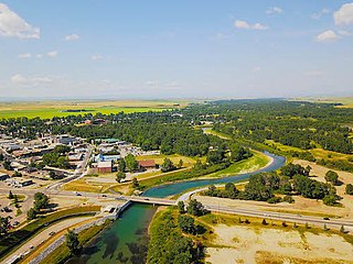
Stettler is a town in east-central Alberta, Canada that is surrounded by the County of Stettler No. 6. The town is nicknamed "The Heart of Alberta".

<span class="mw-page-title-main">Stony Plain, Alberta</span> Town in Alberta, Canada

Stony Plain is a town in the Edmonton Metropolitan Region of Alberta, Canada that is surrounded by Parkland County. It is west of Edmonton adjacent to the City of Spruce Grove and sits on Treaty 6 land.

Coronation is a town in east-central Alberta, Canada that is surrounded by the County of Paintearth No. 18. It is located at the intersection of Highway 12 and Highway 872, approximately 100 kilometres (62 mi) west of the Saskatchewan border.

<span class="mw-page-title-main">Didsbury, Alberta</span> Town in Alberta, Canada

Didsbury is a town in central Alberta, Canada at the foothills of the Rocky Mountains. It is located next to Alberta Highway 2A, near the Queen Elizabeth II Highway. Didsbury is within the Calgary-Edmonton corridor. Didsbury is approximately the half-way point between the cities of Calgary and Red Deer.

<span class="mw-page-title-main">High River</span> Town in Alberta, Canada

High River is a town within the Calgary Metropolitan Region of Alberta, Canada. It is approximately 68 kilometres (42 mi) south of Calgary, at the junction of Alberta Highways 2 and 23. High River had a population of 14,324 in 2021.

<span class="mw-page-title-main">Rimbey</span> Town in Alberta, Canada

Rimbey is a town in central Alberta, Canada. It is located at the junction of Highways 20 and 53 in the Blindman River valley area approximately 62 kilometres (39 mi) northwest of Red Deer and 145 kilometres (90 mi) southwest of Edmonton.

Blackfalds is a town in central Alberta, Canada. It is located along Highway 2A 13.5 km north of Red Deer. The town's name, Waghorn, changed in 1903 to Blackfalds, after Blackfalds, a Scottish hamlet.

<span class="mw-page-title-main">Grande Cache</span> Hamlet in Alberta, Canada

Grande Cache is a hamlet in West-Central Alberta, Canada within and administered by the Municipal District of Greenview No. 16. It is located on Highway 40 approximately 145 kilometres (90 mi) northwest of Hinton and 435 kilometres (270 mi) west of Edmonton. Grande Cache overlooks the Smoky River, is at the northern edge of Alberta's Rockies, and serves as a gateway to the Willmore Wilderness Park. The hamlet held town status prior to 2019.

Paradise Valley is a village in central Alberta, Canada. It is east of Highway 897 approximately 37 km (23 mi) south of Kitscoty.

<span class="mw-page-title-main">Crossfield, Alberta</span> Town in Alberta, Canada

Crossfield is a town in the Calgary Metropolitan Region of Alberta, Canada that is surrounded by Rocky View County. It is located on Highway 2A 43 km (27 mi) north of the City of Calgary.

<span class="mw-page-title-main">Breton, Alberta</span> Village in Alberta, Canada

Breton is a village in central Alberta, Canada. It is located roughly 95 kilometres (59 mi) southwest of Edmonton.

Lomond is a village in southern Alberta, Canada that is surrounded by Vulcan County. It is located at the intersection of Highway 845 and Highway 531, approximately 74 kilometres (46 mi) southwest of Brooks and 49 kilometres (30 mi) east of Vulcan. The village is a farming service community. Lomond was named for Loch Lomond, Scotland.

<span class="mw-page-title-main">Vulcan County</span> Municipal district in Alberta, Canada

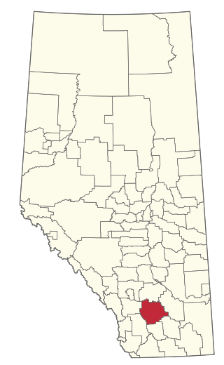
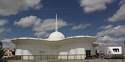
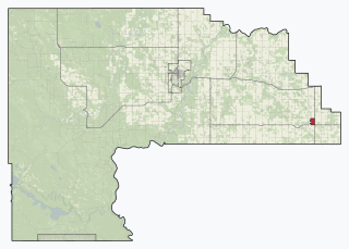
Vulcan County is a municipal district in Alberta, Canada. Located in Census Division No. 5, its municipal office is located in the Town of Vulcan.

<span class="mw-page-title-main">Beaver Mines</span> Hamlet in Alberta, Canada

Beaver Mines is a hamlet in southern Alberta, Canada within the Municipal District of Pincher Creek No. 9. It is located in the foothills of the Canadian Rockies on Highway 507, approximately 19 km (12 mi) west of Pincher Creek.

<span class="mw-page-title-main">Acadia Valley</span> Hamlet in Alberta, Canada

Acadia Valley is a hamlet in southeast Alberta, Canada within the Municipal District (MD) of Acadia No. 34. The MD of Acadia No. 34's municipal office is located in Acadia Valley.

Ashmont, Alberta is a hamlet in northern Alberta, Canada within the County of St. Paul No. 19. It is located near the intersection of Highway 28 and Highway 36, approximately 33 kilometres (21 mi) northwest of the Town of St. Paul. It has an elevation is 2,073 feet (632 m).

<span class="mw-page-title-main">Waterton Park</span> Community in Alberta, Canada

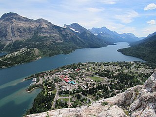
Waterton Park, commonly referred to as Waterton, is a hamlet in southwestern Alberta, Canada within Improvement District No. 4 Waterton.

References

  1. "Location and History Profile: Town of Vulcan" (PDF). Alberta Municipal Affairs. October 7, 2016. p. 716. Retrieved October 13, 2016.
  2. "Municipal Officials Search". Alberta Municipal Affairs. May 9, 2019. Retrieved October 1, 2021.
  3. 1 2 3 "Population and dwelling counts: Canada, provinces and territories, and census subdivisions (municipalities)". Statistics Canada. February 9, 2022. Retrieved February 9, 2022.
  4. "Alberta Private Sewage Systems 2009 Standard of Practice Handbook: Appendix A.3 Alberta Design Data (A.3.A. Alberta Climate Design Data by Town)" (PDF) (PDF). Safety Codes Council. January 2012. pp. 212–215 (PDF pages 226–229). Archived from the original (PDF) on October 16, 2013. Retrieved October 9, 2013.
  5. "Population and dwelling counts: Canada and population centres". Statistics Canada. February 9, 2022. Retrieved February 13, 2022.
  6. 1 2 "Population and dwelling counts, for Canada, provinces and territories, and census subdivisions (municipalities), 2016 and 2011 censuses – 100% data (Alberta)". Statistics Canada. February 8, 2017. Retrieved February 8, 2017.
  7. "Location and History Profile: Town of Vulcan". Alberta Municipal Affairs. May 5, 2015. Retrieved May 7, 2015.
  8. Encyclopaedia Britannica: A New Survey of Universal Knowledge. Encyclopaedia Britannica. 1962.
  9. "Vulcan Review". Internet Archive. March 19, 1912. Retrieved January 25, 2020.
  10. "The Vulcan Advocate" . Retrieved January 25, 2020.
  11. "Vulcan Advocate". vulcanadvocate. Retrieved March 8, 2023.
  12. Canada Flight Supplement. Effective 0901 Z 16 July 2020 to 0901Z 10 September 2020.
  13. "Preserving Vulcan's heritage". The Vulcan Advocate. April 24, 2015. Retrieved January 25, 2020.
  14. "About Vulcan, Alberta's Star Ship FX6-1995-A - Vulcan Tourism". Archived from the original on July 2, 2010. Retrieved July 29, 2010.
  15. The Vulcan Tinman Triathlon. "The Vulcan Tinman Triathlon: History". The Vulcan Tinman Triathlon. Retrieved February 2, 2018.
  16. 1 2 Pawlowski, A. (August 22, 2013). "Live long and prosper in Vulcan, the 'Star Trek Capital of Canada'". NBC News . Retrieved August 22, 2013.
  17. Cernetig, Miro (September 8, 1990). "Small Town Ties Spacey Idea: Vulcan turns to 'Star Trek' to boost image". The Globe and Mail .
  18. "Health | Vulcan". Archived from the original on December 14, 2015. Retrieved August 25, 2015.
  19. "Canadian Climate Normals 1981-2010 Station Data". Environment and Climate Change Canada. September 25, 2013. Retrieved August 21, 2019.

50°24′N113°15′W / 50.400°N 113.250°W / 50.400; -113.250 (Vulcan)