Waldkirchen

Last updated
Waldkirchen
Waldkirchen, FRG - Sickling nordl - Waldkirchen, FRG v W 04.JPG
Waldkirchen seen from the west
DEU Waldkirchen COA.svg
Coat of arms
Location of Waldkirchen within Freyung-Grafenau district
Waldkirchen in FRG.svg
Germany adm location map.svg
Red pog.svg
Waldkirchen
Bavaria location map.svg
Red pog.svg
Waldkirchen
Coordinates: 48°43′49.72″N13°36′4.1″E / 48.7304778°N 13.601139°E / 48.7304778; 13.601139 Coordinates: 48°43′49.72″N13°36′4.1″E / 48.7304778°N 13.601139°E / 48.7304778; 13.601139
Country Germany
State Bavaria
Admin. region Niederbayern
District Freyung-Grafenau
Government
   Mayor (202026) Heinz Pollak [1]
Area
  Total80.06 km2 (30.91 sq mi)
Elevation
573 m (1,880 ft)
Population
 (2020-12-31) [2]
  Total10,732
  Density130/km2 (350/sq mi)
Time zone UTC+01:00 (CET)
  Summer (DST) UTC+02:00 (CEST)
Postal codes
94065
Dialling codes 08581
Vehicle registration FRG
Website www.waldkirchen.de

Waldkirchen is the biggest town in the district of Freyung-Grafenau in Germany.

Contents

History

Waldkirchen township Waldkirchen1.jpg
Waldkirchen township

Mentioned for the first time in 1203, it soon became an important trading place along the "Goldener Steig" (Golden Path), a salt-trading route between Bavaria and Bohemia in the late Middle Ages. In the 13th century the Bishop of Passau gave Waldkirchen the title of a "Markt" (market). After several raids by Bohemian soldiers during the 15th century the city built a "Ringmauer", a big stonewall, to surround it, which is still to be seen in many places of the city.

Belonging to the Bishop of Passau's territory for more than 600 years, the city became part of the Kingdom of Bavaria in 1806 and in 1871 of the German Empire.

Waldkirchen burned down six times between 1492 and 1945. The last fire was on April 26, 1945, when the 16th Company of Regiment Grossdeutschland, SS Panzer Grenadier Division "Das Reich" arrived from St. Pölten, Austria. Each squad of ten men was armed with one light machine gun, one machine pistol, two Panzerfaust and rifles. Eight civilians were killed in combat with the 11th Armored Division, and 48 houses and city's historical church were destroyed. In the course of the action 120 families also lost shelter. The devastated city was rebuilt during the 1950s and was chartered in 1972.

Waldkirchen was host of the 2007 Landesgartenschau.

Inhabitants

Religion

Attractions and Tourism

City Wall Ringmauer l.jpg
City Wall

Attractions in the town include the City Wall, St. Peter's and St. Paul's Churches, the Schratzlgaenge (hidden labyrinth under the town) and the marketplace.

Tourism

Waldkirchen's main "industry" is tourism. Embedded in the Bavarian Forest, Waldkirchen is close to Prague, Munich and Vienna.

Famous people

Related Research Articles

Passau is a Landkreis (district) in the southeast of Bavaria. It encloses the city of Passau geographically from two sides. Neighboring districts are Rottal-Inn, Deggendorf, Freyung-Grafenau. To the south it borders Austria.

Altötting Place in Bavaria, Germany

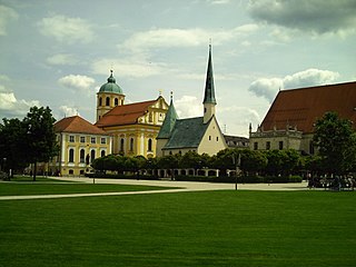
Altötting is a town in Bavaria, capital of the district Altötting of Germany. For 500 years it has been the scene of religious pilgrimages by Catholics in honor of Mary, including a visit by Pope John Paul II in 1980 and one by Pope Benedict XVI in 2006.

Burghausen, Altötting Place in Bavaria, Germany

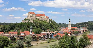
Burghausen is the largest town in the Altötting district of Upper Bavaria in Germany. It is situated on the Salzach river, near the border with Austria. Burghausen Castle rests along a ridgeline, and is the longest castle in the world.

Aldersbach Place in Bavaria, Germany

Aldersbach is a municipality in the district of Passau in Bavaria in Germany. The former Cistercian Aldersbach Abbey, of which the Baroque church remains, is located in the village. There is also a brewery with museum. Aldersbach has around 4,500 inhabitants.

Eichendorf Place in Bavaria, Germany

Eichendorf(Bavarian: Oachadoaf) is a municipality in the district of Dingolfing-Landau in Bavaria in Germany.

Pocking Place in Bavaria, Germany

Pocking is a town in the district of Passau, in Lower Bavaria, Germany. It is situated about 30 km south-west of Passau, close to the Austrian border.

Freyung, Bavaria Place in Bavaria, Germany

Freyung is a town in Bavaria, Germany, capital of the Freyung-Grafenau district. It is situated in the Bavarian Forest mountain range, near the border with Austria and the Czech Republic.

Grafenau, Bavaria Place in Bavaria, Germany

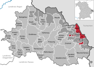
Grafenau is a town in the Freyung-Grafenau district, in Bavaria, Germany. 32 km north of Passau, the town is situated in the Bavarian Forest and is the base of the Bavarian Forest National Park Authority. Grafenau is a holiday destination with a variety of kinds of accommodation from self-catering apartments to a "holiday village".

Neuötting Place in Bavaria, Germany

Neuötting is a town in the district of Altötting, in Bavaria, Germany. It is situated on the river Inn, 2 km north of Altötting, about 70 km north of Salzburg, 80 southwest of Passau and almost 100 km east of Munich. It is a stop on the railway line between Munich and Simbach.

Haidmühle Place in Bavaria, Germany

Haidmühle is a municipality in the district of Freyung-Grafenau in Bavaria in Germany.

Philippsreut Place in Bavaria, Germany

Philippsreut is a municipality in the district of Freyung-Grafenau in Bavaria, Germany. It lies on the border with the Czech Republic.

Bad Griesbach Place in Bavaria, Germany

Bad Griesbach im Rottal, or just Bad Griesbach, is a town in the district of Passau in Bavaria in Germany.

Haarbach Place in Bavaria, Germany

Haarbach is a municipality in the district of Passau in Bavaria in Germany.

Neuburg am Inn Place in Bavaria, Germany

Neuburg am Inn is a municipality in the district of Passau in Bavaria in Germany.

Sonnen Place in Bavaria, Germany

Sonnen is a small municipality in the district of Passau in Bavaria in Germany. It is located in the Danube forest, lower Bavarian forest and is located mostly in the district Passau at a height of 700 to 900 meters. Sonnen lies 28 km from Passau, 9 km from Hauzenberg and from the forest itself 13 km. Sonnen borders with upper Austria which lies only 8 km away.

Tiefenbach, Passau Place in Bavaria, Germany

Tiefenbach is a municipality in the district of Passau in Bavaria in Germany.

Sankt Englmar Place in Bavaria, Germany

Sankt Englmar is a municipality in the district of Straubing-Bogen in Bavaria, Germany.

Hutthurm municipality in Bavaria, Germany

Hutthurm is a municipality in the district of Passau in Bavaria in Germany.

Ortenburg (Bavaria) Place in Bavaria, Germany

Ortenburg is a municipality and old market town in the district of Passau in Bavaria in Germany.

Untergriesbach Place in Bavaria, Germany

Untergriesbach is a municipality in the district of Passau in Bavaria in Germany.

References

  1. Liste der ersten Bürgermeister/Oberbürgermeister in kreisangehörigen Gemeinden, Bayerisches Landesamt für Statistik, 15 July 2021.
  2. "Tabellenblatt "Daten 2", Statistischer Bericht A1200C 202041 Einwohnerzahlen der Gemeinden, Kreise und Regierungsbezirke". Bayerisches Landesamt für Statistik und Datenverarbeitung (in German). June 2021.