
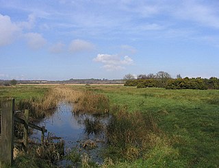
Titchwell Marsh is an English nature reserve owned and managed by the Royal Society for the Protection of Birds (RSPB). Located on the north coast of the county of Norfolk, between the villages of Titchwell and Thornham, about 8 km (5.0 mi) east of the seaside resort of Hunstanton, its 171 hectares include reed beds, saltmarshes, a freshwater lagoon and sandy beach, with a small woodland area near the car park. This internationally important reserve is part of the North Norfolk Coast Site of Special Scientific Interest (SSSI) and the Norfolk Coast Area of Outstanding Natural Beauty (AONB), and is also protected through Natura 2000, Special Protection Area (SPA) and Ramsar listings.

Ouse Washes is a linear 2,513.6-hectare (6,211-acre) biological Site of Special Scientific Interest stretching from near St Ives in Cambridgeshire to Downham Market in Norfolk. It is also a Ramsar internationally important wetland site, a Special Protection Area for birds, a Special Area of Conservation and a Nature Conservation Review site, Grade I. An area of 186 hectares between March and Ely is managed by the Wildlife Trust for Bedfordshire, Cambridgeshire and Northamptonshire and another area near Chatteris is managed by the Royal Society for the Protection of Birds. The Wildfowl & Wetlands Trust manages another area near Welney.

The Somerset Levels are a coastal plain and wetland area of Somerset, England, running south from the Mendips to the Blackdown Hills.

Crossrail was a railway construction project centred around London. It aimed to provide a high-frequency hybrid commuter rail and rapid transit system crossing the capital from suburbs on the west to east, by connecting two major railway lines terminating in London: the Great Western Main Line and the Great Eastern Main Line. The project was approved in 2007, and construction began in 2009 on the central section and connections to existing lines that became part of the route, which has been named the Elizabeth line in honour of Queen Elizabeth II who opened the line on 17 May 2022 during her Platinum Jubilee. The central section of the line between Paddington and Abbey Wood opened on 24 May 2022, with 12 trains per hour running in each direction through the core section in Central London.
Foulness Island is a closed island on the east coast of Essex in England, which is separated from the mainland by narrow creeks. In the 2001 census, the usually resident population of the civil parish was 212, living in the settlements of Churchend and Courtsend, at the north end of the island. The population reduced to 151 at the 2011 Census. The island had until recently a general store and post office. The George and Dragon pub in Churchend closed in 2007, while the church of St Mary the Virgin closed in May 2010. In 2019, the Southend Echo reported plans for the church to be converted into a five-bedroom home.

RSPB Minsmere is a nature reserve owned and managed by the Royal Society for the Protection of Birds (RSPB) at Minsmere, Suffolk. The 1,000-hectare (2,500-acre) site has been managed by the RSPB since 1947 and covers areas of reed bed, lowland heath, acid grassland, wet grassland, woodland and shingle vegetation. It lies within the Suffolk Coast and Heaths Area of Outstanding Natural Beauty and the Suffolk Heritage Coast area. It is conserved as a Site of Special Scientific Interest, Special Area of Conservation, Special Protection Area and Ramsar site.
Minsmere is a place in the English county of Suffolk. It is located on the North Sea coast around 3.5 miles (5.6 km) north of Leiston and 1.5 miles (2.4 km) south-east of Westleton within the Suffolk Coast and Heaths AONB. It is the site of the Minsmere RSPB reserve and the original site of Leiston Abbey.

The River Alde and River Ore form a river system in Suffolk, England passing by Snape and Aldeburgh. The River Alde and River Ore meet northwest of Blaxhall. From there downriver the combined river is known as the River Alde past Snape and Aldeburgh, and then again as the River Ore as it approaches Orford and flows by a shingle spit before emptying into the North Sea.

Wallasea Wetlands is a reclaimed wetlands area located in Essex, England. It has been created as part of a government-funded wetlands scheme to halt the decline of wild and endangered birds caused by the drainage and development of former wetland sites. It is the largest man-made marine wetland area in the United Kingdom.

The River Crouch is a small river that flows entirely through the English county of Essex.

The Caldicot and Wentloog Levels are two areas of low-lying estuarine alluvial wetland and intertidal mudflats adjoining the north bank of the Severn Estuary, either side of the River Usk estuary near Newport in south east Wales. They are also known collectively as the Monmouthshire Levels or Gwent Levels, and the name Wentloog is sometimes spelled Wentlooge in official publications.
The River Roach is a river that flows entirely through the English county of Essex. It is one of four main streams that originate in the Rayleigh Hills to the west, and flow east. They then flow towards the centre of the Rochford Basin, a circular feature which may have been caused by an asteroid impact in the Late Oligocene or Early Miocene periods. To the east of Rochford, the river becomes tidal, and is governed by the Crouch Harbour Authority. It joins the River Crouch between Wallasea Island and Foulness Island. To the west of Rochford, there is some doubt as to which of the four streams is officially the Roach.
The Steart Peninsula is a peninsula in Somerset, England. At its outermost tip is Fenning Island, at the tip of which is Stert Point which is the eastern end of the West Somerset Coast Path. North of Stert Point lies Stert Island, which was joined to the peninsula until about 1798. The peninsula consists largely of low-lying flat farmland, and projects northwards on the west side of Stockland Reach, the lower stretches of the estuary of the River Parrett.

Newport Wetlands is a wildlife reserve covering parts of Uskmouth, Nash and Goldcliff, in the south-east of the city of Newport, South Wales.

Ham Wall is an English wetland National Nature Reserve (NNR) 4 kilometres (2.5 mi) west of Glastonbury on the Somerset Levels. It is managed by the Royal Society for the Protection of Birds (RSPB). Since the last Ice Age, decomposing plants in the marshes of the Brue valley in Somerset have accumulated as deep layers of peat that were commercially exploited on a large scale in the twentieth century. Consumer demand eventually declined, and in 1994 the landowners, Fisons, gave their old workings to what is now Natural England, who passed the management of the 260 hectares Ham Wall section to the RSPB.

The North Norfolk Coast Site of Special Scientific Interest (SSSI) is an area of European importance for wildlife in Norfolk, England. It comprises 7,700 ha (19,027 acres) of the county's north coast from just west of Holme-next-the-Sea to Kelling, and is additionally protected through Natura 2000, Special Protection Area (SPA) listings; it is also part of the Norfolk Coast Area of Outstanding Natural Beauty (AONB). The North Norfolk Coast is also designated as a wetland of international importance on the Ramsar list and most of it is a Biosphere Reserve.
The Shotley Peninsula is a rural area east of the A137 Ipswich-Colchester road located between the rivers Stour and Orwell in Suffolk, England. The peninsula is named after the settlements of Shotley and Shotley Gate which are situated near its south-eastern tip. Other villages on the peninsula include Chelmondiston, Erwarton (Arwarton), Freston, Harkstead, Holbrook, Stutton, Tattingstone, Wherstead and Woolverstone.

Dingle Marshes is a 93-hectare (230-acre) wildlife reserve on the North Sea coast of the English county of Suffolk. The reserve is located between Dunwich and Walberswick, approximately 4 miles (6.4 km) south-west of Southwold. The marshes make up part of the Suffolk Coast National Nature Reserve along with reserves at Walberswick and Hen Reedbeds. They are owned jointly by the RSPB and Suffolk Wildlife Trust and are managed by these two organisations and Natural England. The site is in the Dunwich Heaths and Marshes Nature Conservation Review site, Grade I, the Minsmere-Walberswick Ramsar internationally important wetland site, the Minsmere to Walberswick Heaths and Marshes Special Area of Conservation, and the Minsmere-Walberswick Special Protection Area under the European Union Directive on the Conservation of Wild Birds.
Thurrock Thameside Nature Park is an Essex Wildlife Trust nature reserve located on top of the former Mucking Marshes Landfill in Thurrock, England which will eventually cover 845 acres (342 ha). It is next to the River Thames and provides good bird and ship watching. The Cory Environmental Trust Visitor Centre is located at the preserve and provides a rooftop viewing platform.

The Crouch and Roach Estuaries are a 1729 hectare biological Site of Special Scientific Interest (SSSI) at the mouth of the Crouch and Roach rivers in Essex. The Crouch part of the SSSI stretches from near Battlesbridge to Foulness Island, and the Roach from Rochford to the junction with the Crouch. Part of the site is in the Mid-Essex Coast Special Protection Area under the EC Directive on the Conservation of Wild Birds, and a Ramsar wetland site of international importance. It is also part of the Essex Estuaries Special Area of Conservation. An area of 65 hectares is managed by the Essex Wildlife Trust as the Lion Creek and Lower Raypits nature reserve and 8 hectares at Woodham Fen, both of which are managed by the Essex Wildlife Trust. A small area is also a geological SSSI, The Cliff, Burnham-on-Crouch.

