Waltershausen

Last updated
Waltershausen
Stadtkirche waltershausen.JPG
Wappen Waltershausen.png
Location of Waltershausen within Gotha district
Waltershausen in GTH.svgAspachGoldbachHainaHochheimHohenkirchenHörselLauchaOhrdrufSchwabhausenTonnaWesthausen
Germany adm location map.svg
Red pog.svg
Waltershausen
Thuringia location map.svg
Red pog.svg
Waltershausen
Coordinates: 50°53′51″N10°33′21″E / 50.89750°N 10.55583°E / 50.89750; 10.55583 Coordinates: 50°53′51″N10°33′21″E / 50.89750°N 10.55583°E / 50.89750; 10.55583
Country Germany
State Thuringia
District Gotha
Government
   Mayor (201824) Michael Brychcy [1] (CDU)
Area
  Total71.20 km2 (27.49 sq mi)
Elevation
320 m (1,050 ft)
Population
 (2020-12-31) [2]
  Total12,712
  Density180/km2 (460/sq mi)
Time zone UTC+01:00 (CET)
  Summer (DST) UTC+02:00 (CEST)
Postal codes
99880
Dialling codes 03622
Vehicle registration GTH
Website www.waltershausen.de

Waltershausen is a town in the south-western part of the district of Gotha in the state of Thuringia, Germany.

Contents

Geography

Geographic location

Located on the verge of the Thuringian Basin just before the Thuringian Forest, Waltershausen is sometimes referred to as the "gate to the Thuringian Forest".

It is close to the Großer Inselsberg, the fourth-highest mountain in the state.

Town structure

The town is divided into the seven districts of Fischbach, Schmerbach, Schwarzhausen, Winterstein, Wahlwinkel, Schnepfenthal and Langenhain.

Incorporations

On July 1 in 1950, Langenhain, Schnepfenthal-Rödichen as well as Wahlwinkel became parts of Waltershausen. 63 years later, on December 31 in 2013, the district of Emsetal (consisting of Fischbach, Schmerbach, Schwarzhausen and Winterstein) was incorporated into the town.

History

The origin of the town's name can be traced back to the 8th-9th century when, during Franconian times, a settlement called Waltershausen existed. In 1167, the town's landmark Tenneberg Castle was first mentioned in a document. [3]

The first documentary mention of Waltershausen itself dates back to 1209, precisely under the name of „Ulricus, villicius de Waltherißhusin“. It was then a part of the county of Mühlburg under the electorate of Mainz. From 1640 onwards, Waltershausen, then a subordinate to the Amt Tenneberg, became a part of the duchy of Saxe-Coburg and Gotha.

In the early nineteenth century, Waltershausen established its tradition of being a "city of dolls" due to the high number of toy and specifically doll factories in the area. In 1990, however, the industrial production of dolls came to an end.

In 1929, the Thuringian forest railway was extended to Waltershausen, thus providing a direct connection to Bad Tabarz and Gotha.

During World War II, on February 6 in 1945, Waltershausen was among several regional towns to be hit by an attack of U.S. Forces. 12 bombers dropped a total of 120 bombs on the town, causing the destruction of 21 buildings as well as 20 casualties.

Culture

Landmarks and sights

Sports

Waltershausen offers a variety of sports clubs competing on high levels. Karate athletes of Bushido Waltershausen regularly compete on the national and international stage and have won numerous titles over the years. [5] The town is also a well-known host of regional as well as national table tennis competitions. Its central sports club, ZSG Waltershausen consists of 12 different sports departments. [6]

Media

There are two renowned radio stations in Waltershausen. In 2009, the online radio channel 0800 Radio Tenneberg went on air with daily coverage. Four years later, TMR-radio.de launched, providing recent news and a variety of music. [7]

Recurring events

Waltershausen's Christmas market Christmas Market in Waltershausen.jpg
Waltershausen's Christmas market

The town's biggest event is the annual town fair, taking place in mid-July under a different motto each year. Another recurring event is the medieval castle fair at the beginning of each September.

In December, usually on the weekend of second advent, the annual Christmas market takes place in front of the town hall. A day before Carnival's Monday, a traditional Carnival's parade has been held in Waltershausen for over 25 years.

Religion

There are a total of seven churches and chapels in Waltershausen and its surrounding districts. With the exception of a Catholic chapel established during the 20th century in the town, all of the religious institutions are of Protestant Christianity.

In 1993, Waltershausen became an ecclesiastical administrative center as chair of the Protestant-Lutheran church association of Waltershausen-Ohrdruf. [8]

Infrastructure

Industry

The local economy is highly dependent on its industrial institutions. There are several companies located in or around Waltershausen. One of the most significant examples is a factory by Hako GmbH, where multifunctional equipment transporters called Multicars are being produced.

Rockinger, a trailer hitch producing company, has a factory as well as its headquarters in the town. ContiTech, a subsidiary of Continental, also settled in Waltershausen with one of its factories. [9]

Public transport

Thuringer Waldbahn Thuringer Waldbahn. Reinhardsbrunn Bahnhof.2.ajb.jpg
Thüringer Waldbahn

Due to its proximity to the highway A4 and its own entry to one of Germany's most significant highways connecting Frankfurt and Dresden, Waltershausen is well-connected to the surrounding cities of Eisenach, Gotha as well as Erfurt. The highway is also the gateway to various other parts of Germany, making Waltershausen a very central and easily accessible place from a national perspective.

One of the best-known public transport mediums in the area is the Thüringer Waldbahn  [ de ], connecting Waltershausen to Gotha and Bad Tabarz. Its traditional and nostalgic concept have made it popular beyond the town's border, attracting even non-local tourists.

There are buses and a train line operating in Waltershausen as well.

Education

Waltershausen currently has two primary schools, a secondary school as well as the Salzmannschule Schnepfenthal, a high school focussing on foreign language education. [10]

External relations

Sister cities

International:

National:

Notable people

Hans Kehr in 1902 Kehr.JPG
Hans Kehr in 1902

Related Research Articles

Thuringia State in Germany

Thuringia, officially the Free State of Thuringia, is a state of Germany. Located in central Germany, it covers 16,171 square kilometres (6,244 sq mi), being the sixth smallest of the sixteen German States. It has a population of about 2.1 million.

Eisenach Town in Thuringia, Germany

Eisenach is a town in Thuringia, Germany with 42,000 inhabitants, located 50 kilometres west of Erfurt, 70 km southeast of Kassel and 150 km northeast of Frankfurt. It is the main urban centre of western Thuringia and bordering northeastern Hessian regions, situated near the former Inner German border. A major attraction is Wartburg castle, which has been a UNESCO World Heritage Site since 1999.

Thuringian Forest Mountain range in the German state of Thuringia

The Thuringian Forest, is a mountain range in the southern parts of the German state of Thuringia, running northwest to southeast. Skirting from its southerly source in foothills to a gorge on its north-west side is the Werra valley. On the other side of the Forest is an upper outcrop of the North German Plain, the Thuringian Basin, which includes the city Erfurt. The south and south-east continuation of the range is the highland often called the Thuringian-Vogtlandian Slate Mountains.

Gotha is a Kreis (district) in western central Thuringia, Germany. Neighboring districts are Unstrut-Hainich-Kreis, Sömmerda, the Kreis-free city Erfurt, Ilm-Kreis, Schmalkalden-Meiningen and the Wartburgkreis.

Schmalkalden-Meiningen is a Landkreis in the southwest of Thuringia, Germany. Its neighboring districts are the districts Wartburgkreis, Gotha, Ilm-Kreis, the district-free city Suhl, the district Hildburghausen, the Bavarian district Rhön-Grabfeld, and the district Fulda in Hesse.

Gotha Town in Thuringia, Germany

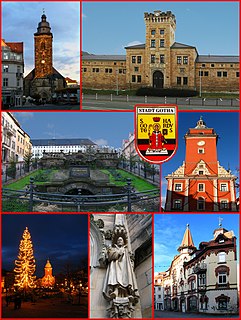
Gotha is the fifth-largest city in Thuringia, Germany, 20 kilometres west of Erfurt and 25 km east of Eisenach with a population of 44,000. The city is the capital of the district of Gotha and was also a residence of the Ernestine Wettins from 1640 until the end of monarchy in Germany in 1918. The House of Saxe-Coburg and Gotha originating here spawned many European rulers, including the royal houses of the United Kingdom, Belgium, Portugal and Bulgaria.

Ohrdruf Town in Thuringia, Germany

Ohrdruf is a small town in the district of Gotha in the German state of Thuringia. It lies some 30 km southwest of Erfurt at the foot of the northern slope of the Thuringian Forest. The former municipalities Crawinkel, Gräfenhain and Wölfis were merged into Ohrdruf in January 2019.

Oberhof, Germany Town in Thuringia, Germany

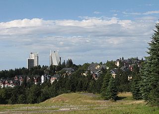
Oberhof is a town in the Schmalkalden-Meiningen district of Thuringia, Germany. Located in the Thuringian Forest mountain range, it is a winter sports center and health resort. With 1,625 inhabitants, it is visited by 144,000 tourists every year (2016). The town obtained its official city status in 1985.

Rudolstadt Town in Thuringia, Germany

Rudolstadt is a town in the German federal state Thuringia, with the Thuringian Forest to the southwest, and to Jena and Weimar to the north.

Schleiz Town in Thuringia, Germany

Schleiz is a town in the district of Saale-Orla-Kreis in Thuringia, Germany. The former municipality Crispendorf was merged into Schleiz in January 2019, and Burgk in December 2019.

Gräfenthal Town in Thuringia, Germany

Gräfenthal is a town in the district of Saalfeld-Rudolstadt in Thuringia, Germany.

Tambach-Dietharz Town in Thuringia, Germany

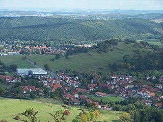
Tambach-Dietharz is a town in the district of Gotha, in Thuringia, Germany. It is situated in the Thuringian Forest, 19 km south of Gotha.

Emsetal Municipality in Thuringia, Germany

Emsetal is a former municipality in the district of Gotha, in Thuringia, Germany. It took its name from the river Emse. It consisted of the villages Fischbach, Schmerbach, Schwarzhausen and Winterstein. On 31 December 2013, it was merged into the town Waltershausen.

The Halle–Bebra railway, also known in German as the Thüringer Bahn, is a 210 kilometre-long railway line from Halle (Saale) via Erfurt and Gerstungen to Bebra, mainly in Thuringia. As far as Gerstungen the line originally belonged to the Thuringian Railway Company. From Gerstungen to Bebra, it was owned by the Frederick William Northern Railway (Friedrich-Wilhelms-Nordbahn), named after the Prussian king, Frederick William IV. It is now a two-track, electrified, standard gauge mainline operated by DB Netze. It was opened between 1846 and 1849 and was the first railway line in Thuringia. All types of trains from Regionalbahn to ICE currently run on the line except Interregio-Express. Four of the six largest cities in Thuringia are located on the line.

Gotha station Railway station in Germany

Gotha station is the main station of Gotha in the German state of Thuringia. It is served by InterCity trains and every two hours by Intercity-Express trains on the Thuringian Railway. Services on the Gotha–Leinefelde line to the north also serve the station. Passenger services on the Ohra Valley Railway (Ohratalbahn) to the south ended in December 2011.

Trams in Gotha

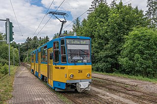
The Gotha tramway network is a network of tramways forming part of the public transport system in Gotha, a city in the federal state of Thuringia, Germany.

Free State of Coburg

The Free State of Coburg emerged from the Duchy of Saxe-Coburg and Gotha at the end of the First World War. It existed from November 1918 until its union with the Free State of Bavaria on 1 July 1920.

Hopfenberg (Waltershausen)

The Hopfenberg is a wooded hill near Winterstein in the borough of Waltershausen, in the county of Gotha in the German state of Thuringia.

Ohra Dam Dam in Landkreis Gotha

The Ohra Dam is a dam which impounds the Ohra in the German state of Thuringia. It lies on the northern side of the Thuringian Forest in the county of Gotha near the village of Luisenthal.

Hornungskuppe

The Hornungskuppe is a wooded hill, 439 m above sea level (NHN), in the Thuringian Zipfel on the border of Hesse and Thuringia in Germany. It is part of the natural region of the Seulingswald.

References

  1. Gewählte Bürgermeister - aktuelle Landesübersicht, Freistaat Thüringen, accessed 14 July 2021.
  2. "Bevölkerung der Gemeinden, erfüllenden Gemeinden und Verwaltungsgemeinschaften in Thüringen Gebietsstand: 31.12.2020". Thüringer Landesamt für Statistik (in German). June 2021.
  3. "Stadt Waltershausen:: Unsere Stadt und ihre Ortsteile:: Waltershausen:: Geschichte". www.waltershausen.de. Retrieved 2019-12-12.
  4. "1730 Tobias-Heinrich-Gottfried-Trost Organ - OrganArt Media". www.organartmedia.com. Retrieved 2019-12-12.
  5. "Bushido Waltershausen - Erfolge / Presse / Ergebnisse". www.bushidowaltershausen-sport.de (in German). Retrieved 2019-12-12.
  6. "ZSG Gruen-Weiss Waltershausen". www.zsg-waltershausen.de. Retrieved 2019-12-12.{{cite web}}: CS1 maint: url-status (link)
  7. "TMR Radio". www.tmr-radio.de. Retrieved 2019-12-12.
  8. "Ev.-Luth. Kirchenkreis Waltershausen". www.evangelisch-in-waltershausen.de. Retrieved 2019-12-12.
  9. WELT (2015-06-22). "ContiTech übernimmt Nachbar-Firma in Waltershausen" . Retrieved 2019-12-12.
  10. "Salzmannschule Schnepfenthal". salzmannschule.de. Retrieved 2019-12-12.{{cite web}}: CS1 maint: url-status (link)