
Bethel Park is a borough with home rule status in Allegheny County, Pennsylvania, United States. It is a suburb within the Pittsburgh metropolitan area, located approximately 7 miles (11 km) south of Pittsburgh. The population was 33,577 as of the 2020 census.

Union Station, also known as Pennsylvania Station and commonly called Penn Station, is a historic train station in Downtown Pittsburgh, Pennsylvania. It was one of several passenger rail stations that served Pittsburgh during the 20th century; others included the Pittsburgh & Lake Erie Railroad Station, the Baltimore and Ohio Station, and Wabash Pittsburgh Terminal, and it is the only surviving station in active use.

The Northeast Corridor Line is a commuter rail service operated by NJ Transit between the Trenton Transit Center and New York Penn Station on Amtrak's Northeast Corridor in the United States. The service is the successor to Pennsylvania Railroad commuter trains between Trenton and New York, and is NJ Transit's busiest commuter rail service. After arrival at New York Penn Station, some trains load passengers and return to New Jersey, while others continue east to Sunnyside Yard for storage. Most servicing is done at the Morrisville Yard, at the west end of the line.

Newark Penn Station is an intermodal passenger station in Newark, New Jersey. One of the New York metropolitan area's major transportation hubs, Newark Penn Station is served by multiple rail and bus carriers, making it the seventh busiest rail station in the United States, and the fourth busiest in the New York City metropolitan area.

Transportation in Philadelphia involves the various modes of transport within the city and its required infrastructure. In addition to facilitating intracity travel, Philadelphia's transportation system connects Philadelphia to towns of its metropolitan area and surrounding areas within the Northeast megalopolis.

Pittsburgh Regional Transit is the second-largest public transit agency in Pennsylvania and the 20th-largest in the United States. The state-funded agency is based in Pittsburgh and is overseen by a CEO and a board of unpaid volunteer directors, some of whom are appointed by the county executive and approved by the county council; and one each by the majority and minority leaders by each political party. After operating as the Port Authority of Allegheny County for most of its history, the agency rebranded under its current name in June 2022. In 2023, the system had a ridership of 39,730,300.

Pittsburgh Railways was one of the predecessors of Pittsburgh Regional Transit. It had 666 PCC cars, the third largest fleet in North America. It had 68 streetcar routes, of which only three are used by the Port Authority as light rail routes. With the Port Authority's Transit Development Plan, many route names will be changed to its original, such as the 41D Brookline becoming the 39 Brookline. Many of the streetcar routes have been remembered in the route names of many Port Authority buses.

A large metropolitan area that is surrounded by rivers and hills, Pittsburgh has an infrastructure system that has been built out over the years to include roads, tunnels, bridges, railroads, inclines, bike paths, and stairways; however, the hills and rivers still form many barriers to transportation within the city.

The Pittsburgh Light Rail is a 26.2-mile (42.2 km) light rail system in Pittsburgh, Pennsylvania, and surrounding suburbs. It operates as a deep-level subway in Downtown Pittsburgh, but runs mostly at-grade in the suburbs south of the city. The system is largely linear in a north-south direction, with one terminus near Pittsburgh's central business district and two termini in the South Hills. The system is owned and operated by Pittsburgh Regional Transit. The T is one of the surviving first-generation streetcar systems in North America, with the oldest portions of the network dating back to 1903 and the Pittsburgh Railways. It is also one of only three light rail systems in the United States that continues to use the broad 5 ft 2+1⁄2 in Pennsylvania Trolley Gauge on its lines instead of the 4 ft 8+1⁄2 instandard gauge. In 2023, the system had a ridership of 3,417,100.

South Hills Village is a station on Pittsburgh Regional Transit's light rail network. It is the southern terminus of both the Red and Blue lines. Port Authority's switching yard and shops are located just west of the station. The station is located in Bethel Park, Pennsylvania and is adjacent to the South Hills Village shopping complex. A large 7-floor, 2,200 space parking garage was completed in 2004 at a cost of $21.6 million and is located on site for commuters traveling from Pittsburgh's South Hills suburbs. The station itself is located at the center-back of the first floor of the garage. In addition to serving as a commuter stop, the site also handles much reverse flow traffic of shoppers from the city and more northerly suburbs.

Library station is a station on Pittsburgh Regional Transit's light rail network, located in the Library neighborhood of South Park, Pennsylvania. It is the southern terminus of the Silver Line. A 430 space park and ride lot is located on the premises, drawing travelers from both South Park and Pittsburgh's suburbs in Washington County, located just to the south. The station is named for the Library neighborhood in which it resides, despite the name, no lending library is near the station.

Willow is a station on the Overbrook branch of Pittsburgh Regional Transit's light rail network. It is located in Castle Shannon, Pennsylvania. It is a transfer point between the Red Line and the Blue and Silver Lines. The station's name was derived from Willow Avenue, the street that runs parallel with and across the light rail. No parking is available at the site and because park and ride commuters can more conveniently reach the nearby Memorial Hall station, Willow almost exclusively serves nearby apartments and individuals switching trains.

West Library is a station on the Port Authority of Allegheny County's light rail network, nearby the Library neighborhood of South Park, Pennsylvania. Primarily a park and ride stop, it features 115 spaces, designed to facilitate the flow of South Park commuters to Downtown Pittsburgh.
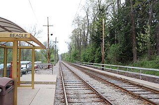
Beagle is a station on the Pittsburgh Regional Transit's light rail network, located in Bethel Park, Pennsylvania. The street level stop is designed as a small commuter stop, serving area residents who walk to the train so they can be taken toward Downtown Pittsburgh.
King's School is a station on the Port Authority of Allegheny County's light rail network, located in Bethel Park, Pennsylvania. The street level stop is designed as a small commuter stop, serving area residents who walk to the train so they can be taken toward Downtown Pittsburgh.

Mesta is a station on the Port Authority of Allegheny County's light rail network, located in Bethel Park, Pennsylvania. The street level stop is designed as a small commuter stop, serving area residents who walk to the train so they can be taken toward Downtown Pittsburgh.

Highland is a station on the Port Authority of Allegheny County's light rail network, located in Bethel Park, Pennsylvania. Located in a railroad cut, the stop is designed as a small commuter stop, serving area residents who walk to the train so they can be taken toward Downtown Pittsburgh. A staircase to each platform is available from Highland Road, which crosses over the line on an overpass. In addition, access to the outbound platform is available through a walkway which leads to Santa Fe Drive. There is no grade crossing for passengers at the station.

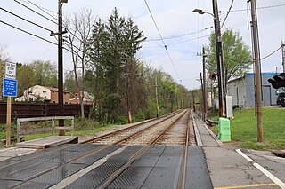
Casswell is a station on Pittsburgh Regional Transit's light rail network, located in Bethel Park, Pennsylvania. The street level stop is designed as a small commuter stop, serving area residents who walk to the train so they can be taken toward Downtown Pittsburgh.

The Blue Line is a Pittsburgh Light Rail line that runs between Downtown Pittsburgh via the Overbrook neighborhood to South Hills Village.

The Silver Line is a line on the Pittsburgh Light Rail system that runs between Downtown Pittsburgh through the Overbrook neighborhood to Library. It is the renamed service for the former Blue Line –Library branch.
