
Leicestershire is a ceremonial county in the East Midlands of England. It is bordered by Derbyshire, Nottinghamshire, and Lincolnshire to the north, Rutland to the east, Northamptonshire to the south-east, Warwickshire to the south-west, and Staffordshire to the west. The city of Leicester is the largest settlement and the county town.

Market Harborough is a market town in the Harborough district of Leicestershire, England, close to the border with Northamptonshire. The population was 24,779 at the 2021 census. It is the administrative headquarters of the Harborough district.
Lutterworth is a market town and civil parish in the Harborough district of Leicestershire, England. The town is located in southern Leicestershire, close to the borders with Warwickshire and Northamptonshire. It is located 6.4 miles north of Rugby, Warwickshire and 12 miles south of Leicester.

Melton Mowbray is a town in the Melton district in Leicestershire, England, 19 miles (31 km) north-east of Leicester, and 20 miles (32 km) south-east of Nottingham. It lies on the River Eye, known below Melton as the Wreake. The town had a population of 27,670 in 2019. The town is sometimes promoted as Britain's "Rural Capital of Food"; it is the home of the Melton Mowbray pork pie and is the location of one of six licensed makers of Stilton cheese.

Oadby and Wigston is a local government district with borough status in Leicestershire, England. It covers the two towns of Oadby, where the council is based, and Wigston, which is the larger town. Both form part of the Leicester urban area, lying south-east of the city.

Harborough is a local government district in Leicestershire, England. It is named after its main town, Market Harborough, which is where the council is based. The district also includes the town of Lutterworth and numerous villages and surrounding rural areas. In the north of the district it includes parts of the Leicester Urban Area, notably at Thurnby, Bushby and Scraptoft. Covering 230 square miles (600 km2), the district is the largest by area of the eight districts in Leicestershire and covers almost a quarter of the county.

Welford is a village and civil parish in the West Northamptonshire unitary authority area of Northamptonshire, England, just south of the River Avon and the border with Leicestershire. At the 2011 Census, the population of the parish was 1,043.

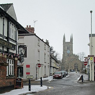
Husbands Bosworth is a large crossroads village in South Leicestershire on the A5199 road from Leicester city to Northampton and the A4304 road from Junction 20 of the M1 motorway to Market Harborough. The population of the village was 1,027 at the 2011 census.
Wilbarston is a village and civil parish in the English county of Northamptonshire in the Welland valley. It is administered as part of North Northamptonshire and is five miles east of the Leicestershire town of Market Harborough, via the A427. At the time of the 2001 census, the parish's population was 767 people, including Pipewell but reducing slightly to 753 at the 2011 Census. A Community Governance Review concluded in February 2015 resulted in the ward of Pipewell becoming part of the civil parish of Rushton.

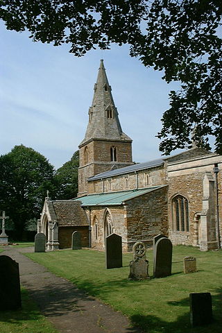
Drayton is a small village and civil parish in the Harborough district of south-east Leicestershire, bordering Northamptonshire and Rutland. It is situated 6.7 miles (11 km) northeast of Market Harborough and 5 miles (7.5 km) southwest of Uppingham on the north side of the Welland valley. Nearby villages are Bringhurst, Great Easton and Nevill Holt. The church of St James in Drayton is one of the smallest churches in England.

Scraptoft is a village in Leicestershire, England. It has a population of about 1,500, measured at the 2011 census as 1,804. It lies north of the A47 road east of Leicester, and runs directly into the built up area of Thurnby and Bushby to the south. For local government the village forms part of the district of Harborough, and constitutes a civil parish.

Great Easton is a village and civil parish in the Harborough district of Leicestershire, England. The parish had a population of 558 according to the 2001 census, increasing to 671 at the 2011 census.

Welham is a small village and civil parish in the Harborough district of Leicestershire, England. Welham lies 4 miles (6 km) north-east of Market Harborough. The village is situated on the north bank of the River Welland, which forms the border with the neighbouring county of Northamptonshire. The population is included in the civil parish of Slawston.

The A508 is a 50.961 kilometres (31.666 mi), A-class road for north–south journeys in central and south central England, forming the route from Market Harborough in Leicestershire, via Northampton, to Old Stratford in Northamptonshire, just outside Milton Keynes.

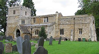
Nevill Holt is a hamlet and civil parish in the Harborough District of Leicestershire, England. It is situated about 6 miles (10 km) northeast of Market Harborough, 5 miles (8 km) northwest of Corby and lies close to the borders with Northamptonshire and Rutland. It is on the north side of the Welland valley. According to the 2001 census the parish had a population of 28. At the 2011 census the population remained less than 100 and was included in the civil parish of Horninghold.
Lubenham is a village and civil parish 2 miles (3.2 km) west of Market Harborough, in the Harborough district, in the south of Leicestershire, England. The first National Hunt Chase Challenge Cup was held in Lubenham, in the grounds of what is now Thorpe Lubenham Hall. Lubenham Parish extends to Gartree in the north and Bramfield Park in the west. The village appears in four entries in the Domesday Book of 1086.

The Robert Smyth Academy is a secondary school in Market Harborough, Leicestershire, England, for 11- to 18-year-olds. It is situated in the north of the town, on Burnmill Road, close to St Luke's Hospital.

Medbourne is a village and civil parish in the Harborough district, in the county of Leicestershire, England. The population of the civil parish at the 2011 census was 473.
Ibstock Community College is a coeducational secondary school located in Ibstock in the English county of Leicestershire.
