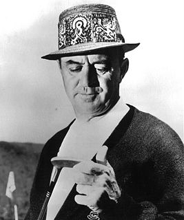
Samuel Jackson Snead was an American professional golfer who was one of the top players in the world for the better part of four decades and one of the greatest players of all time. Snead won a record 82 PGA Tour events, including seven majors. He never won the U.S. Open, though he was runner-up four times.
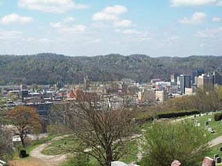
Charleston is the most populous city in, and the capital of, the U.S. state of West Virginia. Located at the confluence of the Elk and Kanawha rivers, the population during the 2017 Census Estimate was 47,929. The Charleston metropolitan area as a whole had 214,406 residents. Charleston is the center of government, commerce, and industry for Kanawha County, of which it is the county seat.

West Virginia University (WVU) is a public, land-grant, space-grant, research-intensive university in Morgantown, West Virginia, United States. Its other campuses include the West Virginia University Institute of Technology in Beckley and Potomac State College of West Virginia University in Keyser; and a second clinical campus for the University's medical and dental schools at Charleston Area Medical Center in Charleston. WVU Extension Service provides outreach with offices in all of West Virginia's 55 counties. Since 2001, WVU has been governed by the West Virginia University Board of Governors.

The Allegheny Mountain Range, informally the Alleghenies and also spelled Alleghany and Allegany, is part of the vast Appalachian Mountain Range of the Eastern United States and Canada and posed a significant barrier to land travel in less technologically advanced eras. The barrier range has a northeast–southwest orientation and runs for about 400 miles (640 km) from north-central Pennsylvania, through western Maryland and eastern West Virginia, to southwestern Virginia.

Marshall University is a public research university in Huntington, West Virginia. It was founded in 1837 and is named after John Marshall, the fourth Chief Justice of the United States.

The Virginian Railway was a Class I railroad located in Virginia and West Virginia in the United States. The VGN was created to transport high quality "smokeless" bituminous coal from southern West Virginia to port at Hampton Roads.

The Allegheny Plateau, in the United States, is a large dissected plateau area in western and central New York, northern and western Pennsylvania, northern and western West Virginia, and eastern Ohio. It is divided into the unglaciated Allegheny Plateau and the glaciated Allegheny Plateau.

The Ridge-and-Valley Appalachians, also called the Ridge and Valley Province or the Valley and Ridge Appalachians, are a physiographic province of the larger Appalachian division and are also a belt within the Appalachian Mountains extending from southeastern New York through northwestern New Jersey, westward into Pennsylvania and southward into Maryland, West Virginia, Virginia, Kentucky, Tennessee, Georgia and Alabama. They form a broad arc between the Blue Ridge Mountains and the Appalachian Plateau physiographic province. They are characterized by long, even ridges, with long, continuous valleys in between.
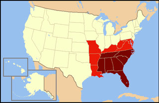
The Southeastern United States is broadly, the eastern portion of the Southern United States, and the southern portion of the Eastern United States. It comprises at least a core of states on the lower Atlantic seaboard and eastern Gulf Coast. Expansively, it includes everything south of the Mason-Dixon line, the Ohio River and the 36°30' parallel, and as far west as Arkansas and Louisiana. There is no official U.S. government definition of the region, though various agencies and departments use different definitions.
West Virginia Public Broadcasting (WVPB) is the public television and radio state network serving the U.S. state of West Virginia. It is owned by the West Virginia Public Broadcasting Authority, an agency of the West Virginia state government that holds the licenses for all Public Broadcasting Service (PBS) and National Public Radio (NPR) member stations licensed in West Virginia. It is headquartered in Charleston with studios in Morgantown and Beckley.

West Virginia Wesleyan College is a private, coeducational, liberal arts college in Buckhannon, West Virginia, United States. It has an enrollment of about 1,400 students from 35 U.S. states and 26 countries. The school was founded in 1890 by the West Virginia Conference of the United Methodist church.

The West Virginia State Capitol is the seat of government for the U.S. state of West Virginia, and houses the West Virginia Legislature and the office of the Governor of West Virginia. Located in Charleston, West Virginia, the building was dedicated in 1932. Along with the West Virginia Executive Mansion it is part of the West Virginia Capitol Complex, a historic district listed on the National Register of Historic Places.

North American telephone area code 304 was established October 1947 as one of the original area codes, and serves all of the U.S. state of West Virginia. It was overlaid with area code 681, effective March 28, 2009.

Wells Goodykoontz was a Republican politician from the U.S. state of West Virginia who served in the West Virginia Legislature representing Mingo County. He was President of the West Virginia Senate from 1917 to 1919, and a Member of the U.S. House of Representatives from the now-defunct 5th congressional district of West Virginia. He served during the 66th and 67th United States Congresses.
The Weirton–Steubenville, WV-OH Metropolitan Statistical Area, also known as the Upper Ohio Valley, is a metropolitan area consisting of two counties in the Northern Panhandle of West Virginia and one in Ohio, anchored by the cities of Weirton and Steubenville. As of the 2010 census, the MSA had a population of 124,454. In 2017, the population was estimated to have gone down to 118,250. This puts it at 329th largest in the United States.
The Parkersburg–Marietta–Vienna Metropolitan Statistical Area, as defined by the United States Census Bureau, is an area consisting of three counties in West Virginia and one in Ohio, anchored by the cities of Parkersburg, West Virginia, Marietta, Ohio, and Vienna, West Virginia. As of the 2000 census, the MSA had a population of 164,264.
The West Virginia Division of Natural Resources (WVDNR) is an agency of the government of the U.S. state of West Virginia. While formerly known as the cabinet-level Department of Natural Resources, it is now part of the West Virginia Department of Commerce. The WVDNR is responsible for wildlife management, hunting and fishing regulations, and boater safety and also oversees state parks and resorts. It also operates the West Virginia State Wildlife Center, a zoo in French Creek that exhibits West Virginian wildlife.