
Thorofare is an unincorporated community and census-designated place (CDP) located within West Deptford Township in northwestern Gloucester County, situated in the South Jersey region of the U.S. state of New Jersey. The area is served as United States Postal Service ZIP Code 08086. As of the 2020 United States census, the CDP's population was 2,806. As of the 2000 census, the population of a different geographic entity containing Thorofare, namely ZIP Code Tabulation Area 08086, was 5,424.
Cookstown is an unincorporated community and census-designated place (CDP) located within New Hanover Township in Burlington County, in the U.S. state of New Jersey. Located near Fort Dix, the area is served as United States Postal Service ZIP Code 08511.
Newport is an unincorporated community and census-designated place (CDP) located within Downe Township in Cumberland County, in the U.S. state of New Jersey. The area is served as United States Postal Service ZIP Code 08345.
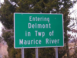
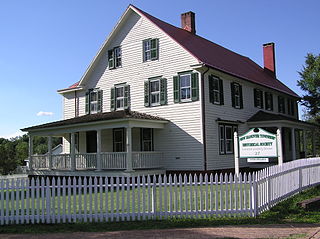
Delmont is an unincorporated community and census-designated place (CDP) located within Maurice River Township, in Cumberland County, in the U.S. state of New Jersey. The area is served as United States Postal Service ZIP Code 08314. It was first listed as a CDP in the 2020 census with a population of 122.

Ledgewood is an unincorporated community and census-designated place (CDP) located within Roxbury Township in Morris County, in the U.S. state of New Jersey. It was historically known as Drakesville after Abraham Drake, originally from Piscataway, New Jersey, who operated a mill and tavern here in the mid 1700s. The community was located on the Morris Canal.

Layton is an unincorporated community and census-designated place (CDP) located within Sandyston Township in Sussex County, in the U.S. state of New Jersey. The area is served as United States Postal Service ZIP Code 07851.
Vauxhall is an unincorporated community and census-designated place (CDP) located within Union Township in Union County, in the U.S. state of New Jersey. Vauxhall borders Millburn, Maplewood and Springfield. The area is served as United States Postal Service ZIP Code 07088.
Hewitt is an unincorporated community and census-designated place (CDP) located within West Milford Township in Passaic County, in the U.S. state of New Jersey. The area is served as United States Postal Service ZIP Code 07421. It is named for Abram Hewitt.
Landing is an unincorporated community and census-designated place (CDP) located within Roxbury Township, in Morris County, in the U.S. state of New Jersey. The community is located on the south shore of Lake Hopatcong near Hopatcong State Park. The area is served as United States Postal Service ZIP Code 07850.
Oak Ridge is an unincorporated community and census-designated place (CDP) located along the border of West Milford Township in Passaic County and Jefferson Township in Morris County, in the U.S. state of New Jersey. The area is served as United States Postal Service ZIP Code 07438.

Gillette is an unincorporated community and census-designated place (CDP) located within Long Hill Township in Morris County, in the U.S. state of New Jersey. The area is served as United States Postal Service ZIP Code 07933.
New Gretna is an unincorporated community and census-designated place (CDP) located within Bass River Township in Burlington County, in the U.S. state of New Jersey. The area is served as United States Postal Service ZIP Code 08224.
Macopin is an unincorporated community and census-designated place (CDP) located within West Milford in Passaic County, in the U.S. state of New Jersey. The area is served as United States Postal Service ZIP Code 07480.

Jobstown is an unincorporated community and census-designated place (CDP) located within Springfield Township in Burlington County, in the U.S. state of New Jersey. The area is served as United States Postal Service ZIP Code 08041.
Great Meadows is an unincorporated community and census-designated place (CDP) located within Independence Township in Warren County, in the U.S. state of New Jersey, that was created as part of the 2010 United States Census. As of the 2010 census, the CDP's population was 303.

Brookside is a historic unincorporated community and census-designated place (CDP) located within Mendham Township in Morris County, in the U.S. state of New Jersey. It is located approximately 6 mi (9.7 km) west of Morristown. It is close to the Washington Valley Historic District in neighboring Morris Township.

Port Murray is an unincorporated community and census-designated place (CDP) located within Mansfield Township in Warren County, in the U.S. state of New Jersey, that was created as part of the 2010 United States Census. As of the 2010 Census, the CDP's population was 129.

Harrisonville is an unincorporated community and census-designated place (CDP) located within South Harrison Township, in Gloucester County, in the U.S. state of New Jersey. The area is served as United States Postal Service ZIP Code 08039.

Ocean View is an unincorporated community and census-designated place (CDP) located within Dennis Township in Cape May County, in the U.S. state of New Jersey. The area is served as United States Postal Service ZIP Code 08230. The post office was established in 1872, with William Doolittle as the first postmaster.

South Dennis is an unincorporated community located within Dennis Township in Cape May County, in the U.S. state of New Jersey. It is part of the Ocean City Metropolitan Statistical Area. Its postal ZIP Code is 08245. The post office was established in 1873, with Robert Hutchinson as the first postmaster.


