Related Research Articles

Rift Valley Province of Kenya, bordering Uganda, was one of Kenya's eight provinces, before the Kenyan general election, 2013. Rift Valley Province was the largest and one of the most economically important provinces in Kenya. It was dominated by the Kenya Rift Valley which passes through it and gives the province its name. According to the 2009 Census, the former province covered an area of 182,505.1 square kilometres and would have had a population of 10,006,805, making it the largest and most populous province in the country. The bulk of the provincial population inhabited a strip between former Nairobi and Nyanza Province. The capital was the town of Nakuru.

The Pokot people live in West Pokot County and Baringo County in Kenya and in the Pokot District of the eastern Karamoja region in Uganda. They form a section of the Kalenjin ethnic group and speak the Pökoot language, which is broadly similar to the related Marakwet, Nandi, Tuken and other members of the Kalenjin language group.

Nakuru County is a county in Kenya. It is County number 32 out of the 47 Kenyan Counties. Nakuru County is a host to Kenya's Fourth City – Nakuru City. On 1 December 2021, President Uhuru Kenyatta awarded a City Charter status to Nakuru, ranking it with Nairobi, Mombasa, and Kisumu as the cities in Kenya. With a population of 2,162,202, it is the third most populous county in Kenya after Nairobi County and Kiambu County, in that order. With an area of 7,496.5 km2, it is Kenya's 19th largest county in size. Until 21 August 2010, it formed part of Rift Valley Province. Nakuru county as a whole has a pleasant climate throughout the year.

The Suguta Valley, also known as the Suguta Mud Flats, is an arid part of the Great Rift Valley in Kenya (Africa), directly south of Lake Turkana.
Kapenguria is a town in Kenya. It is the capital and largest urban center of West Pokot County. The town lies north east of Kitale on the A1 road along Kitale-Lodwar road in north Western Kenya. Kapenguria forms a municipality with a population of 40,751 as per the 2019 Kenya Population and Housing Census.

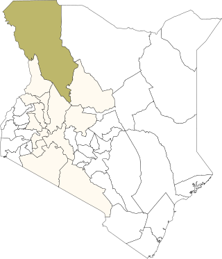
Turkana County is a county in the former Rift Valley Province of Kenya. It is Kenya's largest county by land area of 71,597.8km2 followed by Marsabit County with an area of 66,923.1km2. It is bordered by the countries of Uganda to the west; South Sudan and Ethiopia, including the disputed Ilemi Triangle, to the north and northeast; and Lake Turkana to the east. To the south and east, neighbouring counties in Kenya are West Pokot, Baringo and Samburu Counties, while Marsabit County is on the opposite shore of Lake Turkana. Turkana's capital and largest town is Lodwar. The county had a population of 926,976 at the 2019 census.
West Pokot County is a county of Kenya. Its capital and largest town is Kapenguria. The county covers an area of approximately 9,169.4 square kilometers and stretches a distance of 132 kilometers from north to south. West Pokot County is bordered to the north by Turkana County, to the east by Baringo County, to the southeast by Elgeyo-Marakwet County, to the south by Trans Nzoia County and to the west by Uganda. According to the 2019 census, the county has a population of 621,241. The county is home to Tegla Loroupe, one of the most famous Kenyan female runners.
Kacheliba Constituency is an electoral constituency in Kenya. It is one of the four constituencies of West Pokot County. The constituency has six wards, which are represented by Members of County Assembly at the West Pokot County Assembly in Kapenguria. The constituency was established before the 1988 elections in order to cater for the interests of the Kara-Pokot community following years of under representation. The constituency was created by the Electoral Commission of Kenya through a publication in the Kenya Gazette.
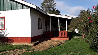
Kacheliba is a settlement in Kenya's Rift Valley Province within West Pokot County. It was the original colonial (British) capital of this county, but due to the heat and malaria, the capital was moved upland to the south to Kapenguria, where it remained.

The Great Rift Valley is part of an intra-continental ridge system that runs through Kenya from north to south. It is part of the Gregory Rift, the eastern branch of the East African Rift, which starts in Tanzania to the south and continues northward into Ethiopia. It was formed on the "Kenyan Dome" a geographical upwelling created by the interactions of three major tectonics: the Arabian, Nubian, and Somalian plates. In the past, it was seen as part of a "Great Rift Valley" that ran from Madagascar to Syria. Most of the valley falls within the former Rift Valley Province.

Sub-counties, formerly known as Districts, are the decentralised units through which government of Kenya provides functions and services. Except for the parts which fall under urban areas, sub-counties will coincide with the constituencies created under article 89 of the Constitution of Kenya. Most sub-counties have a sub-county administrator, appointed by a County Public Service Board. Even though the sub-counties are divisions of counties, powers to create new sub-counties lies with the national government. As of 2023, there are 314 sub-counties, compared to 290 constituencies. A deputy county commissioner is appointed by the state to lead each sub-county.
Uasin Gishu District, also known as Eldoret District, was one of the districts of Kenya, located in the Rift Valley Province. The town of Eldoret was its capital, administrative and commercial centre. It bordered the Trans-Nzoia District.
Turkana District was an administrative district in the Rift Valley Province of Kenya. Turkana was the northwesternmost district in Kenya. It is bordered by the countries of Uganda to the west; South Sudan and Ethiopia, including the disputed Ilemi Triangle, to the north and northeast; and Lake Turkana to the east. To the south and east, neighbouring districts in Kenya are West Pokot, Baringo and Samburu districts, while Marsabit District is located on the opposite shore of Lake Turkana.
Samburu District was a district in Rift Valley Province, Kenya. It covered an area of roughly 21,000 km2 (8,000 mi2) in northern Kenya where the Samburu tribe live. The district had a population of 143,547 in the 1999 census. It stretched north from the Wuaso Ng'iro River to the south of Lake Turkana and also includes Mount Kulal which lies just east of Lake Turkana.
Nandi District was an administrative district in the Rift Valley Province of Kenya. Its capital town was Kapsabet.
Laikipia District was a district of Kenya, located on the Equator in the Rift Valley Province of the country. The district had two major urban centres: Nanyuki to the southeast, and Nyahururu to the southwest. Its capital was Nanyuki.
Samuel Chumel Moroto is a Kenyan politician. He represents Kapenguria Constituency in the Kenyan National Assembly of the Kenyan parliament. He belongs to the Kenya African National Union (KANU) party. He is a career teacher and trade unionist. He was first elected to parliament in 2002. He hails from the Pokot community which mainly inhabits West Pokot County.
The Maliri were a people, recalled by various communities in Kenya and Uganda today, that inhabited regions on the north east of and north west borders of Uganda and Kenya respectively and later spread to regions in southern Ethiopia.
Mutai is a term used by the Maa-speaking communities of Kenya to describe a period of wars, usually triggered by disease and/or drought affecting widespread areas of the Rift Valley region of Kenya. According to Samburu and Maasai tradition, two periods of Mutai occurred during the nineteenth century. The second Mutai lasted from the 1870s to the 1890s.
References
- ↑ "Kenya Districts". www.statoids.com. Retrieved 2023-09-21.
- ↑ "description of the districts and provinces". Syracuse University. p. 4. Retrieved 2 October 2023.
- ↑ "The 2009 Kenya Population and Housing Census" (PDF). Amazonaws. p. 146. Retrieved 28 September 2023.