Western Visayas

Last updated

Western Visayas
Kabisay-an Nakatundan
Kanlurang Kabisayaan
Miagao Church.jpg
White sand beach, Boracay Island - panoramio (2).jpg
Newly renovated Jaro Belfry.jpg
Tibiao, Antique (P. Martin) - Flickr.jpg
The Ruins of Love.jpg
Clockwise from the top: Miagao Church, Jaro Belfry, The Ruins, Tibiao, Boracay
Western Visayas in Philippines.svg
Location in the Philippines
OpenStreetMap
Western Visayas
Coordinates: 11°08′N122°32′E / 11.13°N 122.53°E / 11.13; 122.53
CountryFlag of the Philippines.svg  Philippines
Island group Visayas
Regional center Iloilo City
Largest city Bacolod
Area
  Total20,794.18 km2 (8,028.68 sq mi)
Highest elevation2,465 m (8,087 ft)
Population
 (2020 census) [1]
  Total7,954,723
  Density380/km2 (990/sq mi)
Time zone UTC+8 (PST)
ISO 3166 code PH-06
Provinces
Independent Cities
Component cities
Municipalities 117
Barangays 4,051
Cong. districts 16
Languages
GDP (2023) 1.24 trillion
$22.38 billion [2]
Growth rateIncrease2.svg (7.2%) [2]
HDI Increase2.svg 0.761 (High)
HDI rank 5th in the Philippines (2019)

Western Visayas (Hiligaynon : Kabisay-an Nakatundan; Tagalog : Kanlurang Kabisayaan or Kanlurang Visayas) is an administrative region in the Philippines, numerically designated as Region VI. It consists of six provinces (Aklan, Antique, Capiz, Guimaras, Iloilo and Negros Occidental) and two highly urbanized cities (Bacolod and Iloilo City). The regional center is Iloilo City. [3] The region is dominated by the native speakers of four Visayan languages: Hiligaynon, Kinaray-a, Aklanon and Capiznon. The land area of the region is 20,794.18 km2 (8,028.68 sq mi), and with a population of 7,954,723 inhabitants, it is the second most populous region in the Visayas after Central Visayas. [4]

Contents

On May 29, 2015, the region was realigned, when Western Visayas (Region VI) lost both the province of Negros Occidental and the highly urbanized city of Bacolod to the newly formed Negros Island Region. However, the region was dissolved, resulting in the return of Negros Occidental and Bacolod to Western Visayas Region on August 9, 2017.

Etymology

The region's current name is in reference to its geographic position in the greater Visayas area.

History

Political map of Western Visayas Ph western visayas.png
Political map of Western Visayas

Regions first came into existence on September 24, 1972, when the provinces of the Philippines were organized into 11 regions by Presidential Decree No. 1 as part of the Integrated Reorganization Plan by President Ferdinand Marcos. The provinces of Aklan, Antique, Capiz, Iloilo (including its then-subprovince of Guimaras), and Negros Occidental were grouped together to form the Western Visayas region.

The province of Palawan was transferred to Region VI (Western Visayas) on May 23, 2005, by Executive Order 429. [5] The Department of the Interior and Local Government announced in June 2005 that the transfer had been completed. [6] However, Palaweños criticized the move, citing a lack of consultation, with most residents in Puerto Princesa City and all municipalities but one preferring to stay with Region IV-B. Consequently, Administrative Order No. 129 was issued on August 19, 2005, to address this backlash. This Order directed the abeyance of Executive Order 429 pending the approval of an implementation plan for the orderly transfer of Palawan from Region IV-B to Region VI. [7] Hence, Palawan is currently still part of Region IV-B.

By virtue of Executive Order No. 183 issued on May 29, 2015, by President Benigno Aquino III, the province of Negros Occidental and its capital, Bacolod, were both removed from Western Visayas in order to form the Negros Island Region along with Negros Oriental. [8] But later regained Negros Occidental and its capital, Bacolod City back into Western Visayas on August 9, 2017, when President Rodrigo Duterte dissolved the Negros Island Region, revoking Executive Order No. 183, s. 2015 through the signage of Executive Order No. 38, citing the reason of the lack of funds to fully establish the NIR according to Benjamin Diokno, the Secretary of Budget and Management. [9]

Geography

Western Visayas consists of the major island of Panay and the smaller Guimaras, as well as several outlying islands. It also includes the western half of the larger island of Negros. The region is bordered to the north by the Sibuyan Sea, northeast by the Visayan Sea, east by the province of Negros Oriental in Central Visayas, south by the Iloilo Strait and Panay Gulf, and west by the Sulu Sea.

Map shows the Koppen-Geiger climate classification of the Western Visayas region, Philippines. Climate of Western Visayas.png
Map shows the Koppen-Geiger climate classification of the Western Visayas region, Philippines.

Administrative divisions

Provinces

Western Visayas consists of 6 provinces, 2 highly urbanized cities, 14 component cities, 117 municipalities and 4,051 barangays.

Province orHUCCapitalPopulation (2020) [10] Area [11] [ failed verification ]DensityCitiesMuni.Barangay
km2sq mi/km2/sq mi
Aklan Kalibo 7.7%615,4751,760.30679.66350910017327
Antique San Jose de Buenavista 7.7%612,9742,730.671,054.32220570018590
Capiz Roxas 10.1%804,9522,594.641,001.80310800116473
Guimaras Jordan 2.4%187,842611.87236.243108000598
Iloilo Iloilo City 25.8%2,051,8994,997.641,929.604101,1001421,721
Negros Occidental Bacolod 33.0%2,623,1727,844.123,028.633308501219601
Bacolod 7.6%600,783160.7162.053,7009,60061
Iloilo City 5.8%457,62678.3430.255,80015,000180
Total7,954,72320,778.298,022.54380980161174,051
  •    Bacolod City and Iloilo City are highly urbanized cities ; figures are excluded from Negros Occidental and Iloilo respectively.
  • On May 23, 2005, Executive Order 429 ordered Palawan and the independent city of Puerto Princesa transferred from Region IV-B to Region VI. [7] But on August 19, 2005, Administrative Order 129 ordered the transfer held in abeyance. [5]
Governors and vice governors
ProvinceImageGovernorPolitical PartyVice Governor
Gov Miraflores.png Jose Enrique Miraflores PDP–Laban Reynaldo Quimpo
Official Seal of Antique.svg
Gov Cadiao.png Rhodora Cadiao NUP Edgar Denosta
Gov Castro.png Fredenil Castro Lakas James Magbanua
Gov Nava.png Joaquin Carlos Rahman Nava NUP John Edward Gando
Iloilo Provincial Seal.png
Gov Defensor.png Arthur Defensor Jr. NUP Christine Garin
Ph seal negros occidental.png
Gov Lacson.png Eugenio Jose Lacson NPC Jeffrey Ferrer

Cities


  •   Regional center

Demographics

Population census of Western Visayas
YearPop.±% p.a.
1903 1,083,474    
1918 1,347,249+1.46%
1939 2,173,579+2.30%
1948 2,530,517+1.70%
1960 3,078,305+1.65%
1970 3,618,326+1.63%
1975 4,146,390+2.77%
1980 4,525,615+1.77%
1990 5,393,333+1.77%
1995 5,776,938+1.30%
2000 6,211,038+1.57%
2007 6,843,643+1.35%
2010 7,102,438+1.36%
2015 7,536,383+1.14%
2020 7,954,723+1.07%
Data in 2015 includes Negros Occidental and Bacolod.
Source: Philippine Statistics Authority [1] [12]

Languages

Western Visayas Language Map. Western Visayas Language Map.png
Western Visayas Language Map.

The native languages of Western Visayas are:

Economy

A view of Iloilo City as seen in January 2019 R. Mapa Street, Iloilo City (01-2019).jpg
A view of Iloilo City as seen in January 2019

The major trading and commercial centers of Western Visayas are the cities of Iloilo City in Iloilo; Bacolod and Kabankalan in Negros Occidental; Roxas City in Capiz; San Jose in Antique; and Kalibo in Aklan. Metro Iloilo, composed of Iloilo City and the municipalities of Oton, San Miguel, Pavia, Leganes, Santa Barbara, and Cabatuan, and the island province of Guimaras, is the center for commercial, financial, and industrial activities in the region.

Transportation

Airports

International

Domestic

Municipal

Other

Rail

Proposals to re-connect again Iloilo-Roxas, Iloilo-Kalibo, Iloilo-Malay (Aklan) and Iloilo-San Jose (Antique) from the Iloilo City via rail was included in the revival of the currently defunct Panay Railways network which has a station in Santa Barbara town proper. [20]

Related Research Articles

<span class="mw-page-title-main">Visayas</span> Archipelago in the Philippines

The Visayas, or the Visayan Islands, are one of the three principal geographical divisions of the Philippines, along with Luzon and Mindanao. Located in the central part of the archipelago, it consists of several islands, primarily surrounding the Visayan Sea, although the Visayas are also considered the northeast extremity of the entire Sulu Sea. Its inhabitants are predominantly the Visayan peoples.

<span class="mw-page-title-main">Panay</span> Island in the Philippines

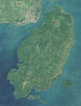
Panay is the sixth-largest and fourth-most populous island in the Philippines, with a total land area of 12,011 km2 (4,637 sq mi) and has a total population of 4,542,926 as of 2020 census. Panay comprises 4.4 percent of the entire population of the country. The City of Iloilo is its largest settlement with a total population of 457,626 inhabitants as of 2020 census.

<span class="mw-page-title-main">Iloilo</span> Province in Western Visayas, Philippines

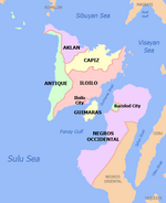
Iloilo, officially the Province of Iloilo, is a province in the Philippines located in the Western Visayas region. Its capital and largest city is Iloilo City, the regional center of Western Visayas. Iloilo occupies the southeast portion of the Visayan island of Panay and is bordered by the province of Antique to the west, Capiz to the north, the Jintotolo Channel to the northeast, the Guimaras Strait to the east, and the Iloilo Strait and Panay Gulf to the southwest.

<span class="mw-page-title-main">Negros Occidental</span> Province in Western Visayas, Philippines

Negros Occidental, officially the Province of Negros Occidental (Hiligaynon: Kapuoran sang Nakatungdang Negros (Negros Occidental; Tagalog: Lalawigan ng Kanlurang Negros, is a province in the Philippines located in the Western Visayas region. Its capital is the city of Bacolod, of which it is geographically situated and grouped under by the Philippine Statistics Authority, but remains politically independent from the provincial government. It occupies the northwestern half of the large island of Negros, and borders Negros Oriental, which comprises the southeastern half. Known as the "Sugarbowl of the Philippines", Negros Occidental produces more than half the nation's sugar output.

<span class="mw-page-title-main">Guimaras</span> Province in Western Visayas, Philippines

Guimaras, officially the Province of Guimaras, is an island province in the Philippines located in the Western Visayas region. The capital is Jordan, while the largest local government unit for it is the municipality of Buenavista. The province is situated in Panay Gulf, between the islands of Panay and Negros. To the northwest is the province of Iloilo and to the southeast is Negros Occidental. The whole island is part of the Metro IloiloGuimaras, one of the twelve metropolitan areas of the Philippines.

<span class="mw-page-title-main">Capiz</span> Province in Western Visayas, Philippines

Capiz, officially the Province of Capiz, is a province in the Philippines located in the central section of Western Visayas region. Its capital is the city of Roxas. It is located at the northeastern portion of Panay Island, bordering Aklan to the north, Antique to the west, and Iloilo to the south. Capiz faces the Sibuyan Sea to the north.

<span class="mw-page-title-main">Bacolod</span> Capital of Negros Occidental, Philippines

Bacolod, officially the City of Bacolod, is a 1st class highly urbanized city in the region of Western Visayas, Philippines. It is the capital of the province of Negros Occidental, where it is geographically situated but governed administratively independent.

<span class="mw-page-title-main">Buenavista, Guimaras</span> Municipality in Guimaras, Philippines

Buenavista, officially the Municipality of Buenavista, is a 2nd class municipality and the largest settlement in the province of Guimaras, Philippines. According to the 2020 census, it has a population of 52,899 people.

<span class="mw-page-title-main">Roman Catholic Archdiocese of Jaro</span> Roman Catholic archdiocese in the Philippines

The Archdiocese of Jaro is a Latin Church archdiocese of the Catholic Church headquartered in Jaro, Iloilo City, Philippines. Its episcopal see is at the Metropolitan Cathedral of St. Elizabeth of Hungary, also the National Shrine of Our Lady of Candles, as its seat. The metropolitan archdiocese covers the provinces of Iloilo, Guimaras, Antique, and Negros Occidental. Its titular patron saint is Elizabeth of Hungary, whose feast is celebrated on November 17.

<span class="mw-page-title-main">Libacao</span> Municipality in Aklan, Philippines

Libacao, officially the Municipality of Libacao, is a 3rd class municipality in the province of Aklan, Philippines. According to the 2020 census, it has a population of 28,272 people.

<span class="mw-page-title-main">Malay, Aklan</span> Municipality in Western Visayas, Philippines

Malay, officially the Municipality of Malay, is a 1st class municipality in the province of Aklan, Philippines. It is the richest municipality in the province in terms of revenue. According to the 2020 census, it has a population of 60,077 people making it the second most populated town in Aklan.

<span class="mw-page-title-main">Nabas, Aklan</span> Municipality in Aklan, Philippines

Nabas, officially the Municipality of Nabas, is a 4th class municipality in the province of Aklan, Philippines. Nabas serves as the arrival gateway of Boracay Airport. According to the 2020 census, it has a population of 40,632 people, making it the fifth most populous town in Aklan Province..

<span class="mw-page-title-main">Kabankalan</span> Component city in Negros Occidental, Philippines

Kabankalan, officially the City of Kabankalan, is a 1st class component city in the province of Negros Occidental, Philippines. According to the 2020 census, it has a population of 200,198 people making it the second most populous city in Negros Occidental next to Bacolod.

<span class="mw-page-title-main">Sipalay</span> Component city in Negros Occidental, Philippines

Sipalay, officially the City of Sipalay, is a 4th class component city in the province of Negros Occidental, Philippines. According to the 2020 census, it has a population of 72,448 people. It is the top tourist destination in the province of Negros Occidental.

<span class="mw-page-title-main">Balasan</span> Municipality in Iloilo, Philippines

Balasan, officially the Municipality of Balasan, is a 4th class municipality in the province of Iloilo, Philippines. According to the 2020 census, it has a population of 35,064 people.

<span class="mw-page-title-main">Carles, Iloilo</span> Municipality in Iloilo, Philippines

Carles, officially the Municipality of Carles, is a 2nd class municipality in the province of Iloilo, Philippines. According to the 2020 census, it has a population of 72,637 people.

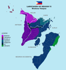
The Hiligaynon people, often referred to as Ilonggo people or Panayan people, are the second largest subgroup of the larger Visayan ethnic group, whose primary language is Hiligaynon, an Austronesian language of the Visayan branch native to Panay, Guimaras, and Negros. They originated in the province of Iloilo, on the island of Panay, in the region of Western Visayas. Over the years, inter-migrations and intra-migrations have contributed to the diaspora of the Hiligaynon to different parts of the Philippines. Today, the Hiligaynon, apart from the province of Iloilo, also form the majority in the provinces of Guimaras, Negros Occidental, Capiz, South Cotabato, Sultan Kudarat, and North Cotabato.

<span class="mw-page-title-main">Metro Iloilo–Guimaras</span> Metropolitan area in the Philippines

Metropolitan Iloilo–Guimaras, also shortened as Metro Iloilo–Guimaras or Metro Iloilo, or simply MIG, is a metropolitan area in the Western Visayas in the Philippines. It is situated on the southeastern coast of Panay, including the nearby island province of Guimaras, surrounded by the Iloilo and Guimaras straits.

<span class="mw-page-title-main">Negros</span> Island in the Philippines

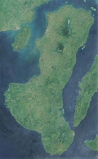
Negros is the fourth largest and third most populous island in the Philippines, with a total land area of 13,309 km2 (5,139 sq mi). The coastal zone of the southern part of Negros is identified as a site of highest marine biodiversity importance in the Coral Triangle.

The COVID-19 pandemic in Western Visayas is part of the worldwide pandemic of coronavirus disease 2019 caused by severe acute respiratory syndrome coronavirus 2. The virus reached Western Visayas on March 20, 2020, when the first case of the disease was confirmed in Bacolod. All provinces have at least one confirmed COVID-19 case.

References

  1. 1 2 Census of Population (2015). "Region VI (Western Visayas)". Total Population by Province, City, Municipality and Barangay. Philippine Statistics Authority . Retrieved June 20, 2016.
  2. 1 2 "2021 to 2023 Gross Regional Domestic Product (GRDP)". openstat.psa.gov.ph. Philippine Statistics Authority. Retrieved April 26, 2024.
  3. "History of Urban Growth of Iloilo City". Iloilo City Government. Archived from the original on June 30, 2012. Retrieved June 28, 2012.
  4. "Region 6 (Western Visayas) | Philippines Cities".
  5. 1 2 President of the Philippines. "Executive order No. 429". Office of the Press Secretary. Archived from the original on July 7, 2007.
  6. "Palawan, Puerto Princesa Transfer to Region VI" (Press release). Government of the Philippines - News. June 3, 2005.
  7. 1 2 President of the Philippines (August 19, 2005). "Administrative Order No. 129". Office of the Press Secretary. Archived from the original on July 13, 2006.
  8. "Executive Order No. 183, s. 2015". Official Gazette (Philippines). May 29, 2015. Retrieved June 5, 2015.
  9. "Duterte dissolves Negros Island Region". Rappler. August 9, 2017. Retrieved August 10, 2017.
  10. 1 2 Census of Population (2020). "Region VI (Western Visayas)". Total Population by Province, City, Municipality and Barangay. Philippine Statistics Authority . Retrieved July 8, 2021.
  11. "PSGC Interactive; List of Provinces". Philippine Statistics Authority . Archived from the original on July 11, 2016.
  12. "Population and Annual Growth Rates for The Philippines and Its Regions, Provinces, and Highly Urbanized Cities" (PDF). 2010 Census and Housing Population. Philippine Statistics Authority. Archived from the original (PDF) on September 28, 2013. Retrieved August 9, 2013.
  13. "Poverty incidence (PI):". Philippine Statistics Authority. Retrieved December 28, 2020.
  14. "Estimation of Local Poverty in the Philippines" (PDF). Philippine Statistics Authority. November 29, 2005.
  15. "2009 Official Poverty Statistics of the Philippines" (PDF). Philippine Statistics Authority. February 8, 2011.
  16. "Annual Per Capita Poverty Threshold, Poverty Incidence and Magnitude of Poor Population, by Region and Province: 1991, 2006, 2009, 2012 and 2015". Philippine Statistics Authority. August 27, 2016.
  17. "Annual Per Capita Poverty Threshold, Poverty Incidence and Magnitude of Poor Population, by Region and Province: 1991, 2006, 2009, 2012 and 2015". Philippine Statistics Authority. August 27, 2016.
  18. "Annual Per Capita Poverty Threshold, Poverty Incidence and Magnitude of Poor Population, by Region and Province: 1991, 2006, 2009, 2012 and 2015". Philippine Statistics Authority. August 27, 2016.
  19. "Updated Annual Per Capita Poverty Threshold, Poverty Incidence and Magnitude of Poor Population with Measures of Precision, by Region and Province: 2015 and 2018". Philippine Statistics Authority. June 4, 2020.
  20. Salvilla, Rex S. (July 28, 2006). "Anything Under the Sun: Panay Railways". The News Today. TNT Publishing, Inc. Retrieved June 12, 2008.