Related Research Articles

The Peak District is an upland area in England, at the southern end of the Pennines. Mostly in Derbyshire, it extends into Cheshire, Greater Manchester, Staffordshire, West Yorkshire and South Yorkshire. It is subdivided into the Dark Peak, moorland dominated by gritstone, and the White Peak, a limestone area with valleys and gorges. The Dark Peak forms an arc on the north, east and west of the district, and the White Peak covers central and southern areas. The highest point is Kinder Scout. Most of the area is within the Peak District National Park, a protected landscape designated in 1951.

Derbyshire is a ceremonial county in the East Midlands of England. It borders Greater Manchester, West Yorkshire, and South Yorkshire to the north, Nottinghamshire to the east, Leicestershire to the south-east, Staffordshire to the south and west, and Cheshire to the west. Derby is the largest settlement, and Matlock is the county town.

High Peak is a local government district with borough status in Derbyshire, England, covering a high moorland plateau in the Dark Peak area of the Peak District National Park. The district stretches from Holme Moss in the north to Sterndale Moor in the south, and from Hague Bar in the west to Bamford in the east. The population of the borough taken at the 2011 Census was 90,892. The borough is unusual in having two administrative centres for its council, High Peak Borough Council; the offices are in Buxton and Glossop. Other towns include Chapel-en-le-Frith, Hadfield, New Mills and Whaley Bridge.
Staffordshire Moorlands is a local government district in Staffordshire, England. Its council is based in Leek, the district's largest town. The district also contains the towns of Biddulph and Cheadle, along with a large rural area containing many villages. North-eastern parts of the district lie within the Peak District National Park.

The White Peak, also known as the Low Peak, is a limestone plateau that forms the central and southern part of the Peak District in England. It is mostly between 270 metres (900 ft) and 430 metres (1,400 ft) above sea-level and is enclosed by the higher altitude Dark Peak to the west, north and east.

Ilam is a village in the Staffordshire Peak District of England, lying on the River Manifold. The population of the civil parish as taken at the 2011 census was 402.

The River Dove is the principal river of the southwestern Peak District, in the Midlands of England, and is around 45 miles (72 km) in length. It rises on Axe Edge Moor near Buxton and flows generally south to its confluence with the River Trent at Newton Solney. From there, its waters reach the North Sea via the Humber Estuary. For almost its entire course it forms the boundary between the counties of Staffordshire and Derbyshire. The river meanders past Longnor and Hartington and cuts through a set of deep limestone gorges, Beresford Dale, Wolfscote Dale, Milldale and Dovedale.
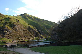
Dovedale is a valley in the Peak District of England. The land is owned by the National Trust and attracts a million visitors annually. The valley was cut by the River Dove and runs for just over 3 miles (5 km) between Milldale in the north and a wooded ravine, near Thorpe Cloud and Bunster Hill, in the south. In the wooded ravine, a set of stepping stones cross the river and there are two caves known as the Dove Holes.
Thorpe Cloud is an isolated limestone hill lying between the villages of Thorpe and Ilam on the Derbyshire/Staffordshire border at the southern end of Dovedale. It is a popular hill amongst the many day-trippers who visit the area, and provides a fine viewpoint north up the dale and south across the Midland plain.

Wolfscote Hill is a limestone hill near the village of Hartington in the Derbyshire Peak District. The summit is 388 metres (1,273 ft) above sea level.

The Manifold Way is a footpath and cycle way in Staffordshire, England. Some 8 miles (13 km) in length, it runs from Hulme End (53.1307°N 1.8480°W) in the north to Waterhouses (53.0480°N 1.8654°W) in the south, mostly through the Manifold Valley and the valley of its only tributary, the River Hamps, following the route of the former Leek and Manifold Valley Light Railway, a 2 ft 6 in gauge line which closed in 1934 after a short life.
Ilam Park is a 158-acre (0.64 km2) country park situated in Ilam, on both banks of the River Manifold five miles (8 km) north west of Ashbourne, England, and in the ownership of the National Trust. The property is managed as part of the Trust's White Peak Estate.

Longshaw Estate is an area of moorland, woodland and farmland within the Peak District National Park in Derbyshire, England.

The Limey Way is a 65-kilometre (40 mi) challenge walk through Derbyshire, England. It starts at Castleton and progresses through 15 major and 5 minor limestone dales to reach the River Dove and Dovedale, the walk's end.
Alsop en le Dale is a village in Derbyshire, England about 5 miles (8.0 km) north of Ashbourne close to the Staffordshire border, and a mile from Dovedale, a popular tourist location within the Peak District national park. It is within the civil parish of Eaton and Alsop.

The River Bradford is a river in the Peak District National Park in Derbyshire. Its source is on Gratton Moor and after passing below Youlgreave it joins the River Lathkill at Alport. Less than 4 miles (7 km) in length, its waters are very clear due to the limestone rock over which it flows, and its width has been enhanced by a number of weirs which also encourage white-throated dippers to breed in the ponds created. The river is owned and managed by the Haddon Estate and is home to brown trout and white-clawed crayfish. The valley is known as Bradford Dale, and the Limestone Way passes through it.

Totley Moor is an open moorland hill to the west of the Sheffield suburb of Totley, in the Derbyshire Peak District. The summit is 395 metres (1,296 ft) above sea level.

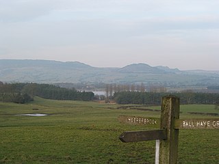
Eaton and Alsop is a civil parish within the Derbyshire Dales district, in the county of Derbyshire, England. Largely rural, in 2021 Eaton and Alsop had a population of only 80 residents. It is 130 miles (210 km) north west of London, 17 miles (27 km) north west of the county city of Derby, and 6 miles (9.7 km) north of the market town of Ashbourne. Eaton and Alsop is wholly within the Peak District national park, and touches the parishes of Alstonefield, Hartington Nether Quarter, Newton Grange and Parwich. There are five listed buildings in Eaton and Alsop.
References
- ↑ "Ilam Park, Dovedale and the White Peak". National Trust. Retrieved 7 February 2024.
- ↑ "National Trust". Made In Derbyshire. Retrieved 7 February 2024.