Whittlesey Mere

Last updated

Map made and printed on satin in 1786 by land surveyor John Bodger Whittlesey Mere map 1786.jpg
Map made and printed on satin in 1786 by land surveyor John Bodger
The present-day site of Whittlesey Mere, looking south towards Tower Farm Whittlesey Mere - geograph.org.uk - 119101.jpg
The present-day site of Whittlesey Mere, looking south towards Tower Farm

Whittlesea Mere was an area of open water in the Fenland area of the county of Huntingdonshire (now Cambridgeshire), England. The mere occupied the land southeast of Yaxley Fen, south of Farcet Fen and north of Holme Fen. The town of Whittlesey lay to the northeast. [1]

Contents

Whittlesea Mere was the last of the 'great meres' to be drained. The old course of the River Nene took it into the mere on one side and out on the other. The area covered by water was at least 1,870 acres (756 hectares) in summer, extending to 3,000 acres (1,214 ha) in winter. The mere was a source of fish, wildfowl, reed and sedge for local inhabitants, and also provided a setting for 'water picnics' for the region's nobility.

According to the traveller Celia Fiennes, who saw it in 1697, the mere was "3 mile broad and six mile long. In the midst is a little island where a great store of Wildfowle breed.... The ground is all wett and marshy but there are severall little Channells runs into it which by boats people go up to this place; when you enter the mouth of the Mer it looks formidable and its often very dangerous by reason of sudden winds that will rise like Hurricanes...." [2]

Circa 1660 map showing the size of Whittlesey Mere Whittlesey Mere 1660.jpg
Circa 1660 map showing the size of Whittlesey Mere

History

Before drainage, the fens contained many shallow lakes, of which Whittlesey Mere was the largest. The River Nene originally flowed through this mere, then south to Ugg Mere, before turning east towards the Ouse. The mere was one of the locations of Lord Orford’s Voyage Round The Fens in 1774 [3] By 1851, silting and peat expansion had reduced Whittlesey Mere to about 400 ha and only a metre deep.

Drainage

The "Black Ham Engine" used in the 1850s to drain Whittlesey Mere. Unique in that it was turf fired The Black Ham Engine - geograph.org.uk - 126248.jpg
The "Black Ham Engine" used in the 1850s to drain Whittlesey Mere. Unique in that it was turf fired
The Ramsey Abbey censer and incense boat in the V&A Museum; they were found when the mere was drained Ramsey Censer and Incense Boat.JPG
The Ramsey Abbey censer and incense boat in the V&A Museum; they were found when the mere was drained

The construction of a new main drain of the Middle Level Navigations to Wiggenhall St Germans [4] completed in 1848, [5] enabled the mere to be drained. A pumping station with an Appold centrifugal pump was used to achieve this, rather than the more traditional scoop wheel. The pump had been shown for the first time at the Great Exhibition in 1851 and its inventor was commissioned to design a pump for the draining of the mere. It was 4.5 feet (1.4 m) in diameter, and powered by a 25 hp (19 kW) steam engine, could raise 101 tons of water per minute by 2 or 3 feet (0.6 or 0.9 m). [6]

The project was funded by a group of gentlemen and local landowners: William Wells of Holmewood; Heathcote of Conington Castle; Edward Fellowes of Ramsey Abbey; Thornhill of Diddington; Lord Sandwich; and Wentworth Fitzwilliam of Milton.

The drainage turned both the mere and Holme Fen into usable farmland, but subsidence followed.

A thurible and other silver items were found in the bed of the mere and from the ram's head on one of these pieces were believed to have come from Ramsey Abbey. [7] The thurible (or censer), [8] incense boat [9] and a sword [10] are now in the Victoria & Albert Museum. Also found in the bed were blocks of quarried stone, [11] which are supposed to have fallen from a barge on their way to the Abbey.

A flood occurred in 1852 and the mere filled with water, but it was drained again. In 1862, the Marshland Sluice gave way under pressure from the tide and water flooded in. It was drained once more and farming resumed. [12]

Modern day

The name 'Whittlesea Mere' remains on maps to this day, although the only water is to be found in farmers' irrigation reservoirs and dykes draining the fertile farmland. Stage 3 of the Great Fen Project may eventually see the mere return to wetland, [13] although the lake bed is now higher than the former shoreline due to the uneven shrinkage of the surrounding peat as it has dried. [14] Subsidence of four metres since 1852 [15] is shown visually at Holme Posts.

Local legends

A local legend, first recounted in The Leisure Hour (1887) by a writer who claimed to have heard it from the principal actor, tells of a cottager's son from Holme who while employed bird scaring on Holme Fen one Sunday in February, 1851, wandered from his post and sank up to his armpits in the reed beds of Whittlesey Mere. Obscured from view, he remained stuck for 19 hours, which he ascertained from the sound of the bells of All Saints Church, Conington, until a fellow villager found him by chance, extricated him and returned him to his parents. [16] [17]

Related Research Articles

<span class="mw-page-title-main">Cambridgeshire</span> County of England

Cambridgeshire is a ceremonial county in the East of England and East Anglia. It is bordered by Lincolnshire to the north, Norfolk to the north-east, Suffolk to the east, Essex and Hertfordshire to the south, and Bedfordshire and Northamptonshire to the west. The largest settlement is the city of Peterborough, and the city of Cambridge is the county town.

<span class="mw-page-title-main">The Fens</span> Natural region on the east coast of England

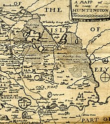
The Fens or Fenlands in eastern England are a naturally marshy region supporting a rich ecology and numerous species. Most of the fens were drained centuries ago, resulting in a flat, dry, low-lying agricultural region supported by a system of drainage channels and man-made rivers and automated pumping stations. There have been unintended consequences to this reclamation, as the land level has continued to sink and the dykes have been built higher to protect it from flooding.

<span class="mw-page-title-main">Ramsey Abbey</span> English Benedictine abbey, now ruins

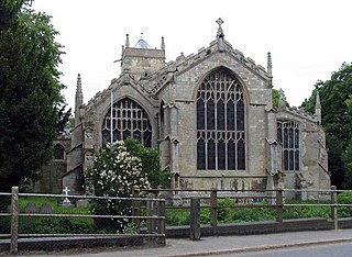
Ramsey Abbey was a Benedictine abbey in Ramsey, Huntingdonshire, England. It was founded about AD 969 and dissolved in 1539.

<span class="mw-page-title-main">Ramsey, Cambridgeshire</span> Human settlement in England

Ramsey is a market town and civil parish in the Huntingdonshire district of Cambridgeshire, England. The town is about 9 miles (14 km) north of Huntingdon. Ramsey parish includes the settlements of Ramsey Forty Foot, Ramsey Heights, Ramsey Mereside, Ramsey Hollow and Ramsey St Mary's.

<span class="mw-page-title-main">Whittlesey</span> Historic market town in Cambridgeshire, England

Whittlesey is a market town and civil parish in the Fenland district of Cambridgeshire, England. Whittlesey is 6 miles (10 km) east of Peterborough. The population of the parish was 17,667 at the 2021 Census.

Holme is a village and civil parish in Cambridgeshire, England. Holme lies approximately 7 miles (11 km) south of Peterborough, near Conington and Yaxley. Holme is situated within Huntingdonshire which is a non-metropolitan district of Cambridgeshire as well as being a historic county of England. The parish contains the lowest point in Great Britain, 2.75 metres (9.0 ft) below sea level.

Benwick is a village and civil parish in the Fenland district of Cambridgeshire, England. It is approximately 15 miles (24 km) from Peterborough and 30 miles (48 km) from Cambridge. The population of Benwick was recorded as 1137 in the United Kingdom Census 2011 with 452 households. The River Nene passes through the village, which is thus accessible by boat from the inland waterways network in England.

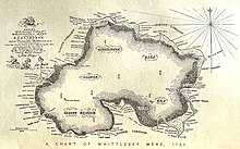
A mere is a shallow lake, pond, or wetland, particularly in Great Britain and other parts of western Europe.

<span class="mw-page-title-main">Middle Level Navigations</span> Waterway network in eastern England

The Middle Level Navigations are a network of waterways in England, primarily used for land drainage, which lie in The Fens between the Rivers Nene and Great Ouse, and between the cities of Peterborough and Cambridge. Most of the area through which they run is at or below sea level, and attempts to protect it from inundation have been carried out since 1480. The Middle Level was given its name by the Dutch Engineer Cornelius Vermuyden in 1642, who subsequently constructed several drainage channels to make the area suitable for agriculture. Water levels were always managed to allow navigation, and Commissioners were established in 1754 to maintain the waterways and collect tolls from commercial traffic.

<span class="mw-page-title-main">Guyhirn</span> Human settlement in England

Guyhirn is a village near the town of Wisbech in Cambridgeshire, England. It is on the northern bank, the North Brink, of the River Nene, at the junction of the A141 with the A47. The population is included in the civil parish of Wisbech St Mary. It is notable chiefly for the Chapel of Ease, a rare example of church architecture of the Interregnum (1649–1660), and as a key crossing point of the River Nene.

<span class="mw-page-title-main">Fens Waterways Link</span> Waterways project in eastern England

The Fens Waterways Link is a project to improve recreational boating opportunities in the counties of Cambridgeshire and Lincolnshire, England. By a combination of improvements to existing waterways and the construction of new links a circular route between Lincoln, Peterborough, Ely and Boston is planned. The project is being organised by the Environment Agency and financed from the Regional Development Agency and the European Union.

<span class="mw-page-title-main">Holme Fen</span>

Holme Fen is a 269.4-hectare (666-acre) biological Site of Special Scientific Interest near Holme in Cambridgeshire. It is also a National Nature Reserve and a Nature Conservation Review site, Grade I. It is part of the Great Fen project, which aims to create a 3,700-hectare wetland wildlife area including Holme Fen, Woodwalton Fen and other areas. It is home to a variety of birds, including the Eurasian siskin, Nightingale and Lesser redpoll, and around 450 species of fungi.

<span class="mw-page-title-main">Middle Level Commissioners</span>

The Middle Level Commissioners are a land drainage authority in eastern England. The body was formed in 1862, undertaking the main water level management function within the Middle Level following the breakup of the former Bedford Level Corporation.

<span class="mw-page-title-main">Outwell</span> Human settlement in England

Outwell is a village and civil parish in the borough of King's Lynn and West Norfolk, in the English county of Norfolk.

Pondersbridge is a village in Whittlesey civil parish, part of the Fenland district of Cambridgeshire, England. Pondersbridge is essentially a settlement which has built up around the river crossing, situated on an artificial drainage cutting called Bevill's Leam. The banks of Bevill's Leam form a strong visual boundary. The older settlement has been extended on the Main Road, north-wards by the local authority housing. The settlement has very limited services and a sporadic development pattern. The main part of Pondersbridge is contained within a triangle of roads - the B1040, the B1095 and The Drove.

<span class="mw-page-title-main">Roddon</span>

A roddon, also written as rodham, roddam or rodden, is the dried raised bed of a watercourse such as a river or tidal-creek, especially in The Fens in eastern England. Such raised silt and clay-filled beds are ideal for settlement in the less firm peat of The Fens. Many writers have followed the archaeologist Major Gordon Fowler's preference for the word roddon to define such structures though modern researchers suggest the word rodham is the more correct local word.

References

  1. "Streetmap.co.uk- search results for 522500,290500". www.streetmap.co.uk. Archived from the original on 24 May 2011.
  2. The Journeys of Celia Fiennes. Edited and introduced by Christopher Morris (London: The Cresset Press, 1949), p. 67.
  3. "Lord Orford's Voyage round the fens". www.huntshistoryfest.com. Retrieved 18 February 2021.
  4. "St Germans Pumping Station: History". Middle Level Commissioners. Archived from the original on 9 October 2013. Retrieved 13 September 2013.
  5. Hinde, K. S. G. (2006). Fenland Pumping Engines. Landmark Publishing Ltd. pp. 38–40. ISBN   978-1-84306-188-5.
  6. Page, William; Proby, Granville; Ladds, S Inskip, eds. (1936). "The Middle Level of the Fens and its reclamation". A History of the County of Huntingdon. Victoria County History. Vol. 3. pp. 249–290. Retrieved 30 December 2010.
  7. "The Ramsey Abbey Censer".
  8. "The Ramsey Abbey Censer".
  9. "The Ramsey Abbey Incense Boat".
  10. "Sword".
  11. "Ramsey Abbey Stones". Yaxley History.
  12. Wentworth Day, J. (1954). A History of the Fens. George G. Harrap & Co. Ltd, London.
  13. "Great Fen Project".
  14. "'Weirder than any other landscape': a wild walk in the Fens". the Guardian. 22 April 2018. Retrieved 26 January 2023.
  15. "Holme Fen Posts | The Great Fen". www.greatfen.org.uk. Retrieved 26 January 2023.
  16. Saunders, W.H. Bernard (1891). "A Legend of Whittlesey Mere". Fenland Notes & Queries. 1: 156–158.
  17. James, Maureen (2014), "Of the Fens and Farming: The Legend of Whittlesey Mere", Cambridgeshire Folk Tales, History Press, ISBN   9780752466286

52°29′59″N0°12′03″W / 52.4996°N 0.2007°W / 52.4996; -0.2007