Wild Horse Reservoir

Last updated
Wild Horse Reservoir
2013-06-16 12 46 26 View southeast across Wild Horse Reservoir in Nevada.jpg
Wild Horse Reservoir viewed from northwest
Relief map of U.S., Nevada.png
Red pog.svg
Wild Horse Reservoir
Location of Wild Horse Reservoir in Nevada
Location Elko County, Nevada
Coordinates 41°40′0.32″N115°48′24.99″W / 41.6667556°N 115.8069417°W / 41.6667556; -115.8069417 [1]
Type Reservoir
Primary inflows Owyhee River, Hot Creek, Penrod Creek, Warm Creek, Poorman Creek
Primary outflows Owyhee River
Basin  countries United States
Surface area2,830 acres (11.5 km2)
Average depth40 feet (12 m)
Max. depth70 feet (21 m)
Water volume71,500 acre-feet (88,200,000 m3) [2]
Surface elevation6,208 feet (1,892 m)

Wild Horse Reservoir is a man-made lake in Elko County, Nevada in the United States. The reservoir was initially created in 1937 by the construction of Wild Horse Dam. In 1969, a new concrete single-angle arch dam was constructed by the United States Bureau of Reclamation for the Bureau of Indian Affairs with a height of 87 feet (27 m) and a length of 458 feet (140 m) at its crest. The original 1937 dam was left in place and is still partly visible. The newer dam doubled the size of the reservoir. [3]

Contents

The reservoir impounds the Owyhee River for flood control and irrigation storage, part of the larger Duck Valley Irrigation Project. The dam and reservoir are owned and administered by the BIA, and leased to the nearby Duck Valley Indian Reservation (Sho-Pai). Recreation on the lake includes fishing for trout, bass, catfish and perch. The state of Nevada also maintains the adjacent Wild Horse State Recreation Area. [4]

The small community of Wild Horse is located on the south shore. [5]

Climate

Wild Horse Reservoir has a humid continental climate (Dfb) bordering on a subalpine climate (Dfc). Summers are warm to hot with brisk nights, and tend to be drier than other times of the year. Winters are very chilly with heavy snowfall and nights near zero.

Climate data for Wild Horse Reservoir, Nevada, 1991–2020 normals, extremes 1982–present
MonthJanFebMarAprMayJunJulAugSepOctNovDecYear
Record high °F (°C)58
(14)
61
(16)
70
(21)
80
(27)
89
(32)
96
(36)
102
(39)
98
(37)
98
(37)
86
(30)
71
(22)
60
(16)
102
(39)
Mean maximum °F (°C)44.7
(7.1)
47.2
(8.4)
58.1
(14.5)
69.5
(20.8)
77.9
(25.5)
87.2
(30.7)
94.1
(34.5)
92.2
(33.4)
87.5
(30.8)
75.8
(24.3)
61.9
(16.6)
47.7
(8.7)
95.0
(35.0)
Average high °F (°C)32.7
(0.4)
36.0
(2.2)
44.3
(6.8)
52.0
(11.1)
62.2
(16.8)
73.2
(22.9)
84.6
(29.2)
83.4
(28.6)
73.6
(23.1)
59.5
(15.3)
44.6
(7.0)
34.0
(1.1)
56.7
(13.7)
Daily mean °F (°C)18.8
(−7.3)
21.8
(−5.7)
30.7
(−0.7)
38.3
(3.5)
46.3
(7.9)
54.4
(12.4)
62.8
(17.1)
61.2
(16.2)
52.2
(11.2)
41.4
(5.2)
30.3
(−0.9)
20.3
(−6.5)
39.9
(4.4)
Average low °F (°C)4.9
(−15.1)
7.6
(−13.6)
17.0
(−8.3)
24.6
(−4.1)
30.4
(−0.9)
35.6
(2.0)
40.9
(4.9)
39.0
(3.9)
30.8
(−0.7)
23.3
(−4.8)
16.0
(−8.9)
6.6
(−14.1)
23.1
(−5.0)
Mean minimum °F (°C)−21.1
(−29.5)
−18.4
(−28.0)
−5.3
(−20.7)
8.7
(−12.9)
16.6
(−8.6)
23.6
(−4.7)
28.8
(−1.8)
26.6
(−3.0)
16.7
(−8.5)
6.8
(−14.0)
−8.4
(−22.4)
−19.3
(−28.5)
−27.5
(−33.1)
Record low °F (°C)−36
(−38)
−42
(−41)
−30
(−34)
−7
(−22)
7
(−14)
16
(−9)
17
(−8)
11
(−12)
5
(−15)
−10
(−23)
−32
(−36)
−42
(−41)
−42
(−41)
Average precipitation inches (mm)1.69
(43)
1.00
(25)
1.20
(30)
1.42
(36)
1.60
(41)
0.78
(20)
0.52
(13)
0.42
(11)
0.56
(14)
0.83
(21)
1.13
(29)
1.69
(43)
12.84
(326)
Average snowfall inches (cm)27.8
(71)
16.7
(42)
14.9
(38)
12.9
(33)
3.9
(9.9)
0.4
(1.0)
0.0
(0.0)
0.0
(0.0)
0.3
(0.76)
2.2
(5.6)
14.3
(36)
23.6
(60)
117.0
(297)
Average extreme snow depth inches (cm)25.4
(65)
25.8
(66)
18.2
(46)
5.6
(14)
0.8
(2.0)
0.0
(0.0)
0.0
(0.0)
0.0
(0.0)
0.0
(0.0)
0.6
(1.5)
7.3
(19)
16.1
(41)
28.9
(73)
Average precipitation days (≥ 0.01 in)11.99.710.211.010.46.04.23.64.55.68.510.896.4
Average snowy days (≥ 0.1 in)9.77.56.75.41.70.10.00.00.31.25.58.947.0
Source 1: NOAA [6]
Source 2: National Weather Service [7]

See also

Related Research Articles

<span class="mw-page-title-main">Colorado River</span> Major river in the western United States and Mexico

The Colorado River is one of the principal rivers in the Southwestern United States and in northern Mexico. The 1,450-mile-long (2,330 km) river, the 5th longest in the United States, drains an expansive, arid watershed that encompasses parts of seven U.S. states and two Mexican states. The name Colorado derives from the Spanish language for "colored reddish" due to its heavy silt load. Starting in the central Rocky Mountains of Colorado, it flows generally southwest across the Colorado Plateau and through the Grand Canyon before reaching Lake Mead on the Arizona–Nevada border, where it turns south toward the international border. After entering Mexico, the Colorado approaches the mostly dry Colorado River Delta at the tip of the Gulf of California between Baja California and Sonora.

<span class="mw-page-title-main">Owyhee River</span> River in Nevada, Idaho, and Oregon, United States

The Owyhee River is a tributary of the Snake River located in northern Nevada, southwestern Idaho and southeastern Oregon in the United States. It is 280 miles (450 km) long. The river's drainage basin is 11,049 square miles (28,620 km2) in area, one of the largest subbasins of the Columbia Basin. The mean annual discharge is 995 cubic feet per second (28.2 m3/s), with a maximum of 50,000 cu ft/s (1,400 m3/s) recorded in 1993 and a minimum of 42 cu ft/s (1.2 m3/s) in 1954.

<span class="mw-page-title-main">Rye Patch State Recreation Area</span> Recreation area in Nevada, United States

Rye Patch State Recreation Area is a 2,400-acre (970 ha) state park unit of Nevada, United States, adjoining Rye Patch Reservoir, an 11,000-acre (4,500 ha) impoundment on the Humboldt River, and the smaller Pitt-Taylor Reservoirs. The recreation area is located at the end of State Route 401, which connects to Interstate 80/U.S. Route 95 about 22 miles (35 km) northeast of Lovelock.

<span class="mw-page-title-main">McPhee Reservoir</span> Reservoir in Montezuma County, Colorado

McPhee Reservoir is located in Montezuma County, Colorado, United States. It was constructed and is operated by the United States Bureau of Reclamation as part of the Dolores Project, and dams the Dolores River to furnish municipal and irrigation water for Montezuma and Dolores counties and the Ute Mountain Ute Indian Reservation.

<span class="mw-page-title-main">South Fork State Recreation Area</span> Recreation area in Nevada, United States

South Fork State Recreation Area is a state park unit of the state of Nevada covering nearly four thousand acres, located five miles (8.0 km) due south of Elko. The park comprises the 1,650-acre (670 ha) South Fork Reservoir and surrounding marsh, meadowlands, and hills.

<span class="mw-page-title-main">Wild Horse State Recreation Area</span> Public recreation area in Nevada, US

Wild Horse State Recreation Area is a public recreation area located on the northeast shore of Wild Horse Reservoir, approximately 67 miles (108 km) north of Elko, Nevada. The 120-acre (49 ha) park is a popular destination for fishing, and especially ice fishing, on the reservoir, which was created in 1937 and enlarged to cover 2,830 acres (1,150 ha) with the creation of a new dam in 1969. In addition to year-round fishing, the park offers opportunities for camping, picnicking, boating, ice skating, sledding, snowmobiling, and skiing.

<span class="mw-page-title-main">Wilson Lake (Kansas)</span> Reservoir in Russell and Lincoln counties in Kansas

Wilson Lake is a reservoir in the U.S. state of Kansas, on the border of Russell County and Lincoln County. Built and managed by the U.S. Army Corps of Engineers for flood control, it is also used for wildlife management and recreation. Several parks are located along its shoreline, including Wilson State Park.

<span class="mw-page-title-main">New Melones Lake</span> Reservoir in California, USA

New Melones Lake is a reservoir on the Stanislaus River in the central Sierra Nevada foothills, within Calaveras County and Tuolumne County, California.

<span class="mw-page-title-main">Nevada State Route 228</span>

State Route 228 (SR 228), also known as Jiggs Highway, is a 20.803-mile (33.479 km) state highway in Elko County, Nevada, United States, that connects Jiggs with Nevada State Route 227 in Spring Creek.

<span class="mw-page-title-main">Bully Creek Reservoir</span> Reservoir in Malheur County, Oregon

Bully Creek Reservoir is a reservoir in Malheur County of the U.S. state of Oregon. It is an impoundment of Bully Creek, a tributary of the Malheur River.

<span class="mw-page-title-main">Salmon Falls Creek</span> River in Nevada and Idaho, United States

Salmon Falls Creek is a tributary of the Snake River, flowing from northern Nevada into Idaho in the United States. Formed in high mountains at the northern edge of the Great Basin, Salmon Falls Creek flows northwards 121 miles (195 km), draining an arid and mountainous basin of 2,103 square miles (5,450 km2). The Salmon Falls Creek valley served as a trade route between the Native American groups of the Snake River Plain and Great Basin. Today, most of its water is used for irrigation.

<span class="mw-page-title-main">Lovewell Reservoir</span> Reservoir in Jewell County, Kansas

Lovewell Reservoir is a reservoir in Jewell County, Kansas, United States. Built and managed by the U.S. Bureau of Reclamation, it is used for flood control, irrigation, and recreation. Lovewell State Park is located on its north shore.

<span class="mw-page-title-main">Rye Patch Reservoir</span> Dam in Pershing County, Nevada

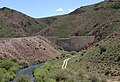
The Rye Patch Reservoir is a reservoir on the Humboldt River in the U.S. State of Nevada. It is located about 22 miles (35 km) northeast of the town of Lovelock, and is managed by the Pershing County Water Conservation District. The reservoir stores water for the agricultural area surrounding Lovelock, which is at the far downstream reach of the Humboldt, near the Humboldt Sink. Since the Lovelock area receives a mere 5.76 inches (146 mm) of rain annually, agriculture requires irrigation, but the high variability of the Humboldt means that water storage is necessary for irrigation to be feasible.

<span class="mw-page-title-main">Webster Reservoir</span> Reservoir in Rooks County, Kansas

Webster Reservoir is a reservoir in Rooks County, Kansas, United States. Built and managed by the U.S. Bureau of Reclamation, it is used for flood control, irrigation, and recreation. Webster State Park is located on its shore.

<span class="mw-page-title-main">Prosser Creek Dam</span> Dam in Nevada County, California, United States of America

Prosser Creek Dam is a dam in Nevada County, California.

<span class="mw-page-title-main">Platoro Dam</span> Dam in Conejos County, Colorado

Platoro Dam is a dam in Conejos County, Colorado.

<span class="mw-page-title-main">Wild Horse, Nevada</span> Unincorporated community in the state of Nevada, United States

Wild Horse is an unincorporated community in Elko County, Nevada, United States. It is located along Nevada State Route 225 just south of Wild Horse Reservoir, from which it derives its name.

<span class="mw-page-title-main">Wilson Reservoir (Nevada)</span> Reservoir in Elko County, Nevada

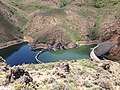
Wilson Reservoir is a man-made lake in Elko County, Nevada in the United States. The reservoir was initially created in 1954 by the construction of Wilson Reservoir Dam. The Petan Ranch owns the reservoir, water rights, and a cabin, but public land surrounding the reservoir is administered by the Bureau of Land Management. The reservoir impounds the Wilson Creek for irrigation storage. It is located 83 miles north-northwest of Elko.

References

  1. "Wild Horse Reservoir". Geographic Names Information System . United States Geological Survey, United States Department of the Interior . Retrieved Jan 17, 2021.
  2. United States Geological Survey (2013). "Wild Horse Reservoir" (PDF). Retrieved 2015-01-11.
  3. "Nevada Department of Wildlife".
  4. "Wild Horse State Recreation Area | State Parks".
  5. "Wild Horse, Nevada". Geographic Names Information System . United States Geological Survey, United States Department of the Interior.
  6. "U.S. Climate Normals Quick Access – Station: Wild Horse RSVR, NV". National Oceanic and Atmospheric Administration. Retrieved January 25, 2023.
  7. "NOAA Online Weather Data – NWS Elko". National Weather Service. Retrieved January 25, 2023.