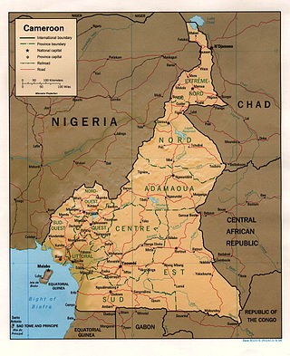
The wildlife of Cameroon is composed of its flora and fauna. Bordering Nigeria, it is considered one of the wettest parts of Africa and records Africa's second highest concentration of biodiversity.[1][2] To preserve its wildlife, Cameroon has more than 20 protected reserves comprising national parks, zoos, forest reserves and sanctuaries. The protected areas were first created in the northern region under the colonial administration in 1932; the first two reserves established were Mozogo Gokoro Reserve and the Bénoué Reserve, which was followed by the Waza Reserve on 24 March 1934. The coverage of reserves was initially about 4 percent of the country's area, rising to 12 percent; the administration proposes to cover 30 percent of the land area.[3]
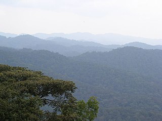
The topography of the country extends from the coastline to hill regions with elevations of up to 2,000 meters (6,600ft). The habitat consists of three regions. These are: The dense rainforests in the southern region in the hot and humid climatic conditions; the central region of semi-deciduous forests; and the northern region consisting of semi-deciduous forests of wooded savanna with scattered trees.[3][4] The climatic conditions are of low to highland with equatorial to tropical climate. Initial coverage of protected areas was in savanna region but it now covers all the ten provinces of the country with all the diversity of its topographic, climatic, hydrological biological features.[3]
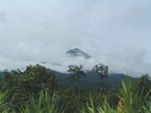
The highest mountain in the country is the Mount Cameroon with an elevation of 4,070 meters (13,350ft). It is located in southwestern Cameroon in the coastal zone close to the Nigerian border.[2]
The total forest area coverage is reported to be 238,623 hectares (589,650 acres) of which 171,090 hectares (422,800 acres) of closed forest and 65,000 hectares (160,000 acres) is fragmented forest or degraded forests accounting for 27 percent of the total forest area. The forests are also categorized as part of the "Congolian Coastal Forests, Western Congo Basin Forests, Sudanian Savannas, Sahelian Flooded Savannas, Gulf of Guinea Rivers and Crater Lakes, Guinean-Congolian Coast Mangroves, and Gulf of Guinea Marine Ecosystems."[5] One of the important regions is the Cameroonian Highlands forests which extends across the Cameroon Highlands, covering an area of 38,000 square kilometers (15,000sqmi) in western Cameroon and eastern Nigeria. The ecoregion lies above 900 metres (3,000ft) elevation, and is surrounded at lower elevations by the Cross-Sanaga-Bioko coastal forests at the southern end of the range, and by forest-savanna mosaic along the central and northern ends of the range; the Cameroon Highlands form the boundary between the Guinean and Northern Congolian forest-savanna mosaic ecoregions, consisting of sub-montane to montane forests and finally sub alpine grasslands. The region is categorized as critical/endangered, but the area under full protection is not great. The area is subject to intense population pressure and conversion of forest lands into agricultural areas.[6]
As part of the Congo Basin, the Sangha River, drained by the tributaries rising in the northern humid region, and flowing into the southern region of the country, is the main water catchment.[7] At the swampy estuary it forms several branches, and is also joined by the Likouala-aux-Herbes, Likouala-Mossaka, and Ubangi (Oubangui) rivers.[8] Another major river, which joins the Sangha River, is the Dja River, which rises in west-central Africa and flows forming the border between Cameroon and the Republic of the Congo, and through the Dja Faunal Reserve, a UNESCOWorld Heritage Site.[9] The major river drainage is the Chari subbasin of the Congo Basin, which covers Cameroon and the Central African Republic. It drains into the Atlantic Ocean.[2]
Many protected areas are still in "pristine" condition, mostly because there is less tourism in Cameroon than other regions of Africa.[10] According to reported statistics, there were ten protected areas from 1932 to 1960. Six protected areas were added between 1960 and 1980, five more were added between 1980 and 2004, and eight protected areas are under consideration within a final approval process.[3]
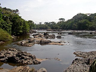
Korup became a national park in 1982.
The protected areas cover 28,104 square kilometres (10,851sqmi) of which 22,784 square kilometres (8,797sqmi) (81 percent) is part of the border protected area. The distribution of this protected area within Cameroon covers: The Lowland forest zones of Dja (5,260 square kilometres (2,030sqmi)) with corridors connecting to the Nki and Minkébé protected areas, the Nki National Park covering 1,950 square kilometres (750sqmi) with ecological corridors to Dja and Boumba–Bek, the Boumba Bek National Park covering 2,330 square kilometres (900sqmi), and the Lobéké National Park covering 2,100 square kilometres (810sqmi) (integrated with the Trinational Park of Cameroon, the Central African Republic, and the Republic of Congo and linked with an Eco-corridor to Boumba–Bek Reserve; the Campo Ma'an National Park of 3,000 square kilometres (1,200sqmi), which borders with the Rio de Campo of Equatorial Guinea; and the Savanna Zone comprising the Waza National Park of 1,700 square kilometres (660sqmi) near Chad border, Faro National Park of 3,300 square kilometres (1,300sqmi) area with common boundary with Nigeria, and the Kalamaloué National Park of 45 square kilometres (17sqmi) on the Chad border.[2]
Falling waters in Korup National Park
Cameroon's first protected area in the northern part of the country was established in 1932 under the French colonial administration of the black francophone Africa. The first forest reserve created was the Mozogo Gokoro Reserve 12 June 1932 and the second in the same year was the Benue Reserve on 19 November 1932. The third reserve, the Waza Reserve was established on 24 March 1934, initially covering an area of 155,000 hectares (380,000 acres) which was extended in 1935 to cover 165,000 hectares (410,000 acres); this is one of the most popular reserves in the country. Until 1975, there were 9 protected areas with greater focus on the north than the south. Following the Earth Summit of Rio de Janeiro in Brazil in 1992, the number of protected areas increased substantially and were well distributed covering all the ten provinces of the country in widely differing topographic, climatic, hydrological and biological conditions.[3] There are 20 protected reserves which include national parks, zoos, forest reserves and sanctuaries.[3]
The evergreen trees found in the rainforests are mahogany, ebony, obeche, dibetu, and sapelli; the trees grow to heights of 200 feet. The trees are also covered with mosses, lichens, and other epiphytes. In the drier woodlands above the rain forests are the tall grasslands and also some areas covered with mountain bamboo. In elevations between 2,400 m and 3,000 m, short grasses are the dominant species, particularly in the region of Mount Cameroon.[4]
Fauna
Leatherback turtle
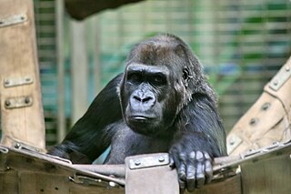
The most endangered species is the Cross River gorilla, a great ape, whose last reported count was 300, spread over 11 scattered sites both in Cameroon and Nigeria. For preservation of this species of ape, the Kagwene Gorilla Sanctuary and the Takamanda National Park have been specifically established in Cameroon.[7]Elephants migrate between the Lake Chad region in Chad and Cameroon; 300 to 400 elephants are reported to live here.[2] In the dense forest areas of the rainforest ecoregion the fauna commonly reported are; red and green monkeys, chimpanzees, mandrills, rodents, bats, and large number of birds like the small sunbirds, giant hawks and eagles. Elephants are also reported in small numbers. The grassy woodlands have baboons and many species of antelope.[4]
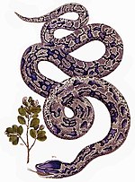
Prominent reptiles reported include the African rock python (Python sebae), the green bush viper (Atheris squamigera) and the African slender-snouted crocodile (Mecistops cataphractus).[11] Marine turtles reported near the coasts of Cameroon in the Atlantic Ocean are the loggerhead (Caretta caretta), Atlantic green (Chelonias mydas), leatherback (Dermochelys coriacea), hawksbill (Eretmochelys imbricata), and the olive ridley (Lepidochelys olivacea). Cameroon has enacted legislation to protect all these species of turtles. Olive ridley, leatherback, and green turtles are reported to nest on the sandy shoreline between Equatorial Guinea and the Wouri Estuary in Cameroon during November to January.[2]
Cameroon has more than 900 bird species which belong to 76 families. Of these 7 are endemic and 20 are specialty species[clarification needed]. With this rich reporting of birds, they are categorized as resident birds (found throughout the year), breeding birds (which breed during the season), and migrants birds found only during specific the seasons and wintering birds which resided here during winter away from the colder regions of the north.[6][12]
The wildlife is under threat due to many factors. These are: conversion of forest land for agricultural use on account of their rich soil derived from volcanic rocks; pressure to meet firewood requirements; forest fires, particularly in grass land areas; the development of industrial complexes hydro-electric power plants and bauxite mining and forest land slotted for the purpose; as well as hunting. Forest loss in the Bamenda-Banso Highlands and also to certain degree in the Obudu Plateau is reported as more than 50% since the 1960s because of conversion to agricultural lands and good rainfall conditions.[1][6] Hunting is recorded in the cross border regions of Cameroon. Trading in bush meat is common in the Sangha River Region; bush meat trade is reported to be concurrent with the logging operations. Hunting for ivory, skins and other animal parts is also reported in many national park areas in Cameroon, from within the country and also from cross border poachers.[2]
Conservation
Many NGOs are working in Cameroon for the conservation and preservation of wild life.
The Sangha Tri National Landscape. The park is labelled.
Conservation efforts in the Sangha River Tri-national Protected Area are in place in a trans-boundary program sponsored by the World Wide Fund for Nature (WWF) with participation by the Central African Republic, the Congo and the Cameroon. This covers a total area of 2,800,000 ha (6,918,951 acres) encompassing the Dzanga Sangha Special Reserve (the second largest area in the world) in the Central African Republic, which incorporates within its ambit the Nouabalé-Ndoki National Park in the Republic of Congo (Brazzaville) and the Lobéké National Park in Cameroon. Appropriate actions are under implementation in respect of anti-poaching, research and the promotion of tourism to the rain forests (the mammal species of particular interest are elephants, apes, ranging from western lowland gorilla to chimpanzees and bongo). The three park-administrations and the prefects of the three countries meet often to ensure proper monitoring of the conservation activities. Patrolling of the parks is a regular joint effort to prevent poaching, smuggling of ivory and unauthorized fishing and carriage of fire arms in the reserve park[16][17]
The German Cooperation of Technical Collaboration (GTC) in Central African Republic and Cameroon, and the World Wildlife Fund for Nature (WWF) and Wildlife Conservation Society (WCS - New York) in the Congo are providing large funds for conservation of the parks.[16][17]
A particular success story of the enabled protection, particularly in the Nouabalé-Ndoki National Park is of the special group of 'eco-guards', who operate under the MFEE (Ministry of Forestry Economy and the Environment), unlike the past practice of deploying rangers, which is reported to have stopped illegal human activities taking place in the park such as poaching.[18]
Ape Action Africa is one such non-profit NGO which was established in 1996 with the primary objective of conservation of endangered gorillas and chimpanzees, which are threatened by the bushmeat trade in Central and West Africa. The NGO not only helps in the rescue and rehabilitation of great apes but also helps in management of a large sanctuary in the Mefou forest.[19]
At 475,440 km2 (183,570 sq mi), Cameroon is the world's 53rd largest country. It is slightly larger than the nation of Sweden and the US state of California. It is comparable in size to Papua New Guinea. Cameroon's landmass is 472,710 km2 (182,510 sq mi), with 2,730 km2 (1,050 sq mi) of water.
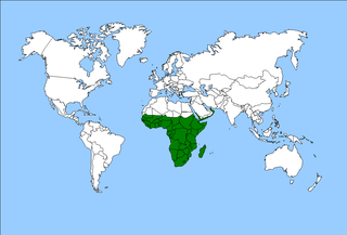
The Afrotropical realm is one of Earth's eight biogeographic realms. It includes Sub-Saharan Africa, the southern Arabian Peninsula, the island of Madagascar, and the islands of the western Indian Ocean. It was formerly known as the Ethiopian Zone or Ethiopian Region.
The Nyungwe Forest is located in southwestern Rwanda, on the border with Burundi, where it is contiguous with the Kibira National Park to the south, and Lake Kivu and the Democratic Republic of the Congo to the west. The Nyungwe rainforest is probably the best preserved montane rainforest in Africa. It is located in the watershed between the basin of the river Congo to the west and the basin of the river Nile to the east. From the east side of the Nyungwe forest comes also one of the branches of the Nile sources.
The Cross–Sanaga–Bioko coastal forests are a tropical moist broadleaf forest ecoregion of west-central Africa. This is lush forest, rich in flora and birdlife.
The Albertine Rift montane forests is a tropical moist broadleaf forest ecoregion in east-central Africa. The ecoregion covers the mountains of the northern Albertine Rift, and is home to distinct Afromontane forests with high biodiversity.
The Cameroonian Highlands forests, also known as the Cameroon Highlands forests, are a montane tropical moist broadleaf forest ecoregion located on the range of mountains that runs inland from the Gulf of Guinea and forms the border between Cameroon and Nigeria. This is an area of forest and grassland which has become more populous as land is cleared for agriculture.
The wildlife of the Democratic Republic of the Congo includes its flora and fauna, comprising a large biodiversity in rainforests, seasonally flooded forests and grasslands.
The wildlife of Rwanda comprising its flora and fauna, in prehistoric times, consisted of montane forest in one third the territory of present-day Rwanda. However, natural vegetation is now mostly restricted to the three national parks and four small forest reserves, with terraced agriculture dominating the rest of the country.
The Atlantic Equatorial coastal forests, also known as the Congolian coastal forests, are a tropical moist broadleaf forest ecoregion of Central Africa, covering hills, plains, and mountains of the Atlantic coast of Cameroon, Equatorial Guinea, Gabon, Republic of the Congo, Angola, and Democratic Republic of the Congo.
Nouabalé-Ndoki National Park is a national park in the Republic of the Congo. Established in 1993, in the northern provinces of Congo, it is home to forest elephants, great apes, including western lowland gorillas and the eastern sub-species of chimpanzees and bongo. It is 3,921.61 km2 (1,514.14 sq mi) of pristine tropical rainforest with no human habitation within it and with human population densities in its periphery that are comparatively low for the sub-region. The forests have a rich biodiversity of 300 bird species, plus 1,000 plant and tree species which include endangered mahoganies.
Lobéké National Park is a national park of southeastern Cameroon within the Moloundou Arrondissement of East Province. Located in the Congo Basin, it is bounded on the east by the Sangha River which serves as Cameroon's international border with Central African Republic and the Republic of the Congo. It is adjacent to two other reserves in the CAR and Congo. To the northwest is Boumba Bek National Park, another national park in Cameroon's East Province.
The Dzanga-Ndoki National Park is located in the southwestern extremity of the Central African Republic. Established in 1990, the national park is 1,143.26 square kilometres (441.42 sq mi). The national park is split into two non-continuous sectors, the northern Dzanga sector 49,500 ha and the southern Ndoki sector 72,500 ha. Notable in the Dzanga sector is a gorilla density of 1.6/km2 (4.1/sq mi), one of the highest densities ever reported for the western lowland gorilla.
The wildlife of the Central African Republic is in the vast natural habitat in the Central African Republic (CAR) located between the Congo Basin's rain forests and large savannas, where the human density was smaller than 0.5 per km2 prior to 1850. The forest area of 22.755 million, considered one of the richest storehouses of wildlife spread over national parks, hunting reserves and community hunting areas, experienced an alarming loss of wildlife because of greed for ivory and bushmeat exploitation by hunters – mostly Arab slavers from across the borders of the Central African Republic with Chad and Sudan.
The Eastern Congolian swamp forests are a fairly intact but underresearched ecoregion of the tropical and subtropical moist broadleaf forests biome. It is located within the Democratic Republic of the Congo. This is the eastern half of one of the largest areas of swamps in the world.
The Kahuzi-Biega National Park is a protected area near Bukavu town in eastern Democratic Republic of the Congo. It is situated near the western bank of Lake Kivu and the Rwandan border. Established in 1970 by the Belgian photographer and conservationist Adrien Deschryver, the park is named after two dormant volcanoes, Mount Kahuzi and Mount Biega, which are within its limits. With an area of 6,000 square kilometres (2,300 sq mi), Kahuzi-Biega is one of the biggest national parks in the country. Set in both mountainous and lowland terrain, it is one of the last refuges of the rare species of Eastern lowland gorilla, an endangered category under the IUCN Red List. The park is a UNESCO World Heritage Site, inscribed in 1980 for its unique biodiversity of rainforest habitat and its eastern lowland gorillas. In 1997, it was listed on the List of World Heritage in Danger because of the political instability of the region, an influx of refugees, and increasing wildlife exploitation.
Lomami National Park is a national park located in the Democratic Republic of Congo in Central Africa. Situated within the middle basin of the Lomami River, it straddles the Provinces of Tshopo and Maniema with a slight overlap into the forests of the Tshuapa and Lualaba river basins. The National Park was formally declared on 7 July 2016. It is the 9th national park in the country and the first to be created since 1992.
The Northeastern Congolian lowland forests is a tropical moist broadleaf forest ecoregion that spans the Democratic Republic of the Congo and the Central African Republic.
The Northwestern Congolian lowland forests is a tropical moist broadleaf forest ecoregion that spans Cameroon, Gabon, the Republic of Congo, the Central African Republic and a minuscule part of the Democratic Republic of the Congo. It forms part of the larger Congolian rainforests region in Central Africa. The region is noteworthy for very high levels of species richness and endemism. It is home to a core population of the critically endangered Western lowland gorilla. There are also large populations of forest elephants.
The Western Congolian forest–savanna mosaic is an ecoregion of Angola, Democratic Republic of the Congo, Republic of the Congo, and Gabon.
This page is based on this Wikipedia article Text is available under the CC BY-SA 4.0 license; additional terms may apply. Images, videos and audio are available under their respective licenses.