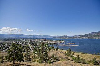
Kelowna is a city on Okanagan Lake in the Okanagan Valley in the southern interior of British Columbia, Canada. It serves as the head office of the Regional District of Central Okanagan. The name Kelowna derives from the Okanagan word kiʔláwnaʔ, referring to a grizzly bear.

William Richards Bennett, was the 27th premier of British Columbia from 1975 to 1986. He was a son of Annie Elizabeth May (Richards) and former premier W. A. C. Bennett. He was a third cousin, twice removed, of R. B. Bennett, eleventh prime minister of Canada.

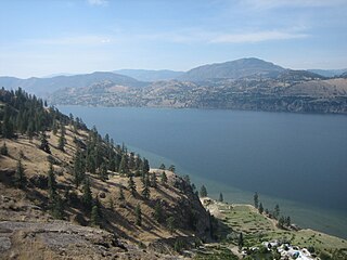
Okanagan Lake is a lake in the Okanagan Valley of British Columbia, Canada. The lake is 135 km (84 mi) long, between 4 and 5 km wide, and has a surface area of 348 km2.
Highway 97 is a major highway in the Canadian province of British Columbia. It is the longest continuously numbered route in the province, running 2,081 km (1,293 mi) and is the only route that runs the entire north–south length of the British Columbia, connecting the Canada–United States border near Osoyoos in the south to the British Columbia–Yukon boundary in the north at Watson Lake, Yukon.

The Regional District of Central Okanagan (RDCO) is a regional district in the Canadian province of British Columbia, representing two unincorporated Electoral Areas of Central Okanagan East and Central Okanagan West, along with the member municipalities of the City of Kelowna, City of West Kelowna the District of Lake Country, the District of Peachland and Westbank First Nation. The RDCO office is located in Kelowna.
Okanagan-Westside was a provincial electoral district for the Legislative Assembly of British Columbia, Canada from 2001 to 2009.
Skaha Lake is a freshwater lake, through which the Okanagan River flows, in the Okanagan region of south central British Columbia. Along the shoreline are Penticton (north), Kaleden (west), and Okanagan Falls (south).
The Okanagan Lake Bridge was a three-lane, 650-metre (2,133-foot) long floating bridge in British Columbia, Canada. It crossed Okanagan Lake, connecting the Westside area to Kelowna on the lake's eastern side. Taller boats such as sailboats were able to pass under the lift span which was located at the east end of the bridge.

The Westbank First Nation is a self-governing First Nations band in the Okanagan region of British Columbia, Canada, and is one of eight bands that comprise the Okanagan Nation Alliance. Westbank First Nation (WFN) is governed by one chief and four councillors, elected every three years by WFN membership. As of April 2019, WFN's membership totaled 914 members, and employs more than 200 people.
The UBC's Okanagan Campus is one of the University of British Columbia's campus located in Kelowna, British Columbia, Canada.

West Kelowna, formerly known as Westbank and colloquially known as Westside, is a city in British Columbia's Okanagan Valley. The city encompasses several distinct neighbourhoods, including Casa Loma, Gellatly, Glenrosa, Lakeview Heights, Shannon Lake, Smith Creek, Rose Valley, Westbank, and West Kelowna Estates. West Kelowna had an estimated population of 34,883 as of December 31, 2018.

Kelowna West, formerly Westside-Kelowna, is a provincial electoral district in British Columbia, Canada, established by the Electoral Districts Act, 2008. It was first contested in the 2009 general election. The riding was created out of parts of Okanagan-Westside, Kelowna-Lake Country and Kelowna-Mission. It was renamed Kelowna West in the 2015 electoral redistribution with only minor boundary changes.
The Coast Meridian Overpass is a four-lane cable stayed bridge in Port Coquitlam, British Columbia, crossing the Canadian Pacific railyard. The new bridge has a width of 25 metres and a length of 580 m. The bridge has a bike lane on the northbound side and a separated pedestrian walkway on the southbound side of the overpass. The construction project, officially launched in 2008, links Coast Meridian Road and Lougheed Highway on the north with Kingsway Avenue and Broadway Street on the south. The speed limit on the bridge is 50 km/h.

Floats are airtight hollow structures, similar to pressure vessels, designed to provide buoyancy in water. Their principal applications are in watercraft hulls, aircraft floats, floating pier, pontoon rhinos, pontoon causeways, and marine engineering applications such as salvage.

Mission Creek is a large creek in the Okanagan Region of British Columbia. Originally called N'wha-kwi-sen, it was later mapped as Rivière de l’Anse-au-Sable, the name Mission Creek was adopted in 1860 in honour of the Catholic Oblate Mission established by Father Pandosy and other settlers. The Creek rises in the Greystoke Mountain Range and runs west about 43 kilometres (27 mi) before emptying into Okanagan Lake south of Kelowna. Its watershed covers about 200,000 square kilometres . Mission Creek was designated a BC Heritage River by the province in 1996.
97 Express Kelowna RapidBus or 97 Okanagan is a bus rapid transit line operated by Kelowna Regional Transit System since September 2010 in Central Okanagan, British Columbia, Canada. The service connects UBC Okanagan Exchange, Downtown Kelowna and Westbank Centre. 97X RapidBus offers high speed bus service by utilizing traffic signal priority and HOV lanes on Highway 97.
MV Aricia was a ferry that operated on Okanagan Lake in British Columbia, Canada. She was built in 1912 by J. Y. Campbell and was also known as the Kelowna-Westbank ferry, because she served the communities of Kelowna and Westbank, British Columbia.
MV Lloyd-Jones was a steel ferry that operated on Okanagan Lake in British Columbia, Canada. She carried cars and freight between the communities of Kelowna and West Kelowna with two other boats, MV Lequime and MV Pendozi. However, they struggled to carry the load, especially after the opening of the Okanagan Lake Bridge in 1958. Lloyd-Jones was launched in July 1950. She had a capacity of 35 cars and was the last of a large fleet of ferries on Okanagan Lake.


