Mount Holyoke, a traprock mountain, elevation 935 feet (285 m), is the westernmost peak of the Holyoke Range and part of the 100-mile (160 km) Metacomet Ridge. The mountain is located in the Connecticut River Valley of western Massachusetts, and is the namesake of nearby Mount Holyoke College. The mountain is located in the towns of Hadley and South Hadley, Massachusetts. It is known for its historic summit house, auto road, scenic vistas, and biodiversity. The mountain is crossed by the 110-mile (180 km) Metacomet-Monadnock Trail and numerous shorter trails. Mount Holyoke is the home of J.A. Skinner State Park which is accessible from Route 47 in Hadley, Massachusetts.

West Springfield is a city in Hampden County, Massachusetts, United States. It is part of the Springfield, Massachusetts Metropolitan Statistical Area. The population was 28,835 at the 2020 United States Census. The city is also known as "West Side", in reference to the fact that it is on the western side of the Connecticut River from Springfield, a fact which played a major part in the town's early history.
The Calvin Coolidge Memorial Bridge is a major crossing of the Connecticut River in Western Massachusetts, connecting the towns of Northampton and Hadley. The bridge carries Route 9 across the river, where it connects to Interstate 91.

Interstate 391 (I-391) is an auxiliary Interstate Highway located entirely within the US state of Massachusetts. It runs from the I-91/I-391 interchange in Chicopee to the center of Holyoke, a distance of about 4.46 miles (7.18 km). It runs near the Connecticut River throughout its journey in Chicopee, crosses into Holyoke, and abruptly ends at High Street 0.4 miles (0.64 km) south of US Route 202 (US 202).

The Charles M. Braga Jr. Memorial Bridge, also known as the Braga Bridge, is a through truss bridge that carries Interstate 195 over the Taunton River between the town of Somerset and the city of Fall River, near the mouth of the Quequechan River at the confluence with Mount Hope Bay. At just over a mile long, it is one of the longest bridges in Massachusetts. Opened to traffic on April 15, 1966, it provides an important link between Providence, Rhode Island, New Bedford, and Cape Cod.

The Norwottuck Rail Trail Bridge is a former crossing of Boston and Maine Railroad over the Connecticut River in western Massachusetts, connecting the towns of Northampton and Hadley, by the Norwottuck Rail Trail, which is currently used for bicycle and foot traffic.

The Hampden County Memorial Bridge is a reinforced-concrete arch bridge that spans the Connecticut River between Springfield, Massachusetts and West Springfield, Massachusetts, constructed in 1922. The bridge is owned by Massachusetts Highway Department and is located on Massachusetts Route 147. It spans 209 feet (64 m) and rises 29.71 feet (9.06 m) above the river.

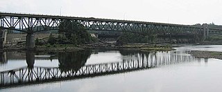
The Schell Memorial Bridge is a steel cantilever Pennsylvania (Petit) truss bridge spanning the Connecticut River in the town of Northfield, Massachusetts. Designed by Edward S. Shaw, the bridge abutments and piers were built by the firm of Ellis & Buswell of Woburn, Massachusetts, and the superstructure was built by the New England Structural Company of East Everett, Massachusetts. The bridge was commissioned by Francis R. Schell, who gave $42,000 for design and construction. Construction began in 1901 and was completed in 1903. In 1985, due to advanced deterioration of the steel truss members, the bridge was barricaded and abandoned.
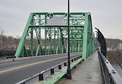
The Turners Falls–Gill Bridge, is a steel deck truss bridge crossing the Connecticut River in Massachusetts. It connects the Town of Gill with the village of Turners Falls in the Town of Montague. The bridge carries automobile and pedestrian traffic.

Route 116 is a 68.26-mile-long (109.85 km) north–south state highway in Massachusetts. The route runs from Route 20A in Springfield through mill towns, college towns and rural towns, crossing the Connecticut River three times before finally ending at Route 8 in Adams.

The Holyoke Range or Mount Holyoke Range is a traprock mountain range located in the Connecticut River Valley of Massachusetts. It is a sub-range of the narrow, linear Metacomet Ridge that extends from Long Island Sound near New Haven, Connecticut north through the Connecticut River Valley of Massachusetts to the Vermont border. A popular hiking destination, the range is known for its anomalous east–west orientation, high ledges and its scenic character. It is also notable for its unique microclimate ecosystems and rare plant communities, as well as significant historic sites, such as the Mount Holyoke Summit House and the Horse Caves.

The Carreau Block is a historic Classical Revival apartment block at 640-642 Chicopee Street in Chicopee, Massachusetts. It was built in 1912 by Louis Carreau, a locally notable builder of French Canadian extraction, and is his only known surviving building of this type. It was listed on the National Register of Historic Places in 1998.

The Amtrak Old Saybrook–Old Lyme Bridge is the last crossing of the Connecticut River before it reaches Long Island Sound. It is a Truss bridge with a bascule span, allowing boat traffic to pass through. The bridge is owned by Amtrak and used by Northeast Regional, Acela Express, Shore Line East and a few freight trains traversing the Northeast Corridor. It can be seen from the Raymond E. Baldwin Bridge, as well as from various points on Route 154.
Edward Sargent Shaw was a prominent civil engineer who lived in Cambridge, Massachusetts. Born on October 26, 1853, he spent most of his life in Cambridge, and graduated from the Massachusetts Institute of Technology with a bachelor's degree in civil engineering in the class of 1874; his thesis being a design for a Murphy-Whipple truss bridge. Immediately following graduation he continued his studies in some non-degree capacity at his alma mater. During his professional career, his office was located in Boston, Massachusetts. He died of heart failure at the age of 65, on October 3, 1919.

The East Washington Avenue Bridge refers to the bridges that have connected East Washington Avenue over the Pequonnock River in Bridgeport, Connecticut. Records state that a bridge was first constructed on the site in 1836, but no description of the bridge has been found. The second bridge was a truss swing design and underwent heavy repair and modernization in 1893. The third design was a movable Strauss underneath-counter weight deck-girder bascule bridge. The plans were drafted by James A. McElroy, using Joseph B. Strauss's design in 1916. However, construction was delayed for years because of a dispute with the contractor and a lack of funds. The bridge was completed by Bridgeport Dry Dock and Dredging when the State of Connecticut appropriated $350,000 to erect the bridge. Completed in 1925, the bridge underwent several modifications throughout its service life. On July 26, 1983, the bridge was closed after it was found to be in danger of collapse. It reopened after repair, but was closed in the 1990s before being replaced with a modern bascule bridge in 1998. In 2010, the report listed the deck and superstructure conditions as "Good" and the substructure condition as "Satisfactory".

Holyoke station is an Amtrak intercity train station near the corner of Main and Dwight streets in Holyoke, Massachusetts, United States. The station opened on August 27, 2015, eight months after Amtrak's Vermonter service was re-routed to the Connecticut River Line through the Pioneer Valley.

The Tyngsborough Bridge is a steel tied-arch bridge located in Tyngsborough, Massachusetts and carries Route 113 over the Merrimack River. With a span of 547 feet, it has the longest span of any steel rib through arch bridges in Massachusetts. It is also the 2nd oldest steel rib through arch bridge in the state. The bridge is center hinged and features pratt-type trussing.
The Rio Vista Bridge is a continuous truss span with a vertical-lift bridge in the middle which carries California State Route 12 across the Sacramento River at Rio Vista, California. The present bridge was completed in 1960 and is one of several moveable bridges spanning rivers in the Sacramento–San Joaquin River Delta. It is named after Helen Madere, who served as vice-mayor of Rio Vista. As of 2013 the bridge carries approximately 21,000 cars per day.

The Holyoke Dam, also referred to as the Hadley Falls Dam, or Hadley Falls Station is a granite dam built in tandem with the Holyoke Canal System at Hadley Falls on the Connecticut River, between Holyoke and South Hadley, Massachusetts. The water differential created by the dam produced mechanical hydropower for industrial uses in Holyoke, and later hydroelectric power.