
Louth is a market town and civil parish in the East Lindsey district of Lincolnshire, England. Louth serves as an important town for a large rural area of eastern Lincolnshire. Visitor attractions include St James' Church, Hubbard's Hills, the market, many independent retailers, and Lincolnshire's last remaining cattle market.

West Lindsey is a local government district in Lincolnshire, England. Its council is based in Gainsborough and covers the towns of Market Rasen and Caistor, as well as the villages of Bardney, Saxilby, Morton, Hemswell Cliff, Scampton, Torksey, Cherry Willingham, Nettleham and Dunholme.
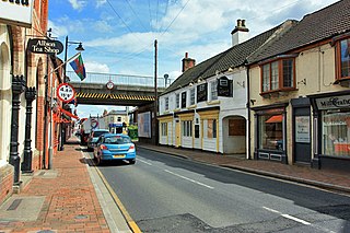
Market Rasen is a market town and civil parish within the West Lindsey district of Lincolnshire, England. The River Rase runs through it east to west, approximately 13 miles (21 km) north-east from Lincoln, 18 miles (29 km) east from Gainsborough, 14 miles (23 km) west of Louth and 16 miles (26 km) south-west from Grimsby. It lies on the main road between Lincoln and Grimsby, the A46 and is famous for its racecourse. In 2001 the town had a population of 3,200. In the 2011 census the population of the civil parish was 3,904.

Caistor is a town and civil parish in the West Lindsey district of Lincolnshire, England. As its name implies, it was originally a Roman castrum or fortress. It lies at the north-west edge of the Lincolnshire Wolds, on the Viking Way, and just off the A46 between Lincoln and Grimsby, at the A46, A1084, A1173 and B1225 junction. It has a population of 2,601. Its name comes from the Anglo-Saxon ceaster and was given in the Domesday Book as Castre.

The Caistor Canal was a 4-mile (6.4 km) canal in Lincolnshire, England, constructed between 1793 and 1798. It fell into disuse sometime after 1850 and was legally abandoned in 1936. It ran from the River Ancholme, near South Kelsey toward Caistor through six locks, terminating at Moortown, 3.5 miles (5.6 km) away from its intended terminus at Caistor. Parts of it were dredged in 2010, to aid flood defences in South Kelsey.
Reepham is a small village in the West Lindsey district of Lincolnshire, England. It is situated 5 miles (8.0 km) north-east from the city and county town of Lincoln. Village population is approximately 1,250, reducing to 915 at the 2011 census.
The Priory Pembroke Academy is a school for pupils aged 11–16 on Croft Lane in the village Cherry Willingham, located just outside the city of Lincoln, England.
De Aston School is a mixed secondary school with academy status in Market Rasen, Lincolnshire, England. It also has a sixth form but no longer has a boarding house as of 2020, following the country's decision to leave the European Union, due to its declining popularity and dwindling funds. The school has a broad Christian ethos but accommodates those of other faiths.

Goltho is a hamlet in the West Lindsey district of Lincolnshire, England. The population was 157 at the 2011 census. It is situated 1 mile (1.6 km) south-west from Wragby, and 0.5 miles (0.8 km) south from the A158 road.

The A631 is a road running from Sheffield, South Yorkshire to Louth, Lincolnshire in England. It passes through the counties of South Yorkshire, Nottinghamshire and Lincolnshire. The road has many towns on its route including Rotherham, Maltby, Gainsborough and Market Rasen. It is mostly single road throughout its length but has some stretches of dual carriageway as well.

Ludford is a village and civil parish in the East Lindsey district of Lincolnshire, England. The parish is composed of the villages of Ludford Magna and Ludford Parva.
Osgodby is a village and civil parish in the West Lindsey district of Lincolnshire, England. The population of the civil parish, including Kingerby, Kirkby and Usselby, and West Rasen in its own civil parish, was 660 at the 2011 census.

(Emilia) Jessie Boucherett was an English campaigner for women's rights.

Claxby and Usselby railway station was a station that served the hamlets of Claxby and Usselby in Lincolnshire, England. It was opened in 1848 on a branch line of the Great Grimsby and Sheffield Junction Railway to Market Rasen but closed in 1960.

The Louth to Bardney Line was an English railway line built by the Louth and Lincoln Railway Company, in Lincolnshire, England. It opened in stages between 1874 and 1876, after serious difficulties in raising subscription capital, and following alteration to the planned route. It was hoped to serve large reserves of ironstone along its route, but the deposits were not as large as hoped, and the line was never financially successful.
Edward James Willson (1787–1854) was an English architect, antiquary, architectural writer, and mayor of Lincoln in 1851–2.

South Willingham is a village and civil parish in the East Lindsey district of Lincolnshire, England, and partly within the Lincolnshire Wolds Area of Outstanding Natural Beauty,. It is situated 1 mile (2 km) south of the A157 Lincoln to Louth road, 15 miles (24 km) west of Lincoln, where the central Lincolnshire Vale and the Lincolnshire Wolds meet. Its population was 160 at the 2011 census, down from a maximum of 341 in 1851.

North Willingham is a village and civil parish in the West Lindsey district of Lincolnshire, England. The population of the civil parish was 181 at the 2011 census. It is situated 3.5 miles (6 km) east from the town of Market Rasen on the A631 road between Market Rasen and Louth.

Lieutenant-Colonel Ayscoghe Boucherett, was a British landowner, businessman and Member of Parliament for Great Grimsby from 1796 to 1803.
Lieutenant-Colonel Michael Barne was a British military officer and a Member of Parliament for Dunwich between 1812 and 1830.
