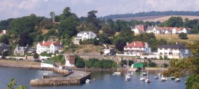
Aberdour is a scenic and historic village on the south coast of Fife, Scotland. It is on the north shore of the Firth of Forth, looking south to the island of Inchcolm and its Abbey, and to Leith and Edinburgh beyond. According to the 2011 census, the village has a population of 1,633.
Kinglassie is a small village and parish in central Fife, Scotland. It is located two miles southwest of Glenrothes. It has a population of around 1,900 (mid-2020 est.) The civil parish has a population of 22,543.

Fife is a council area, historic county, registration county and lieutenancy area of Scotland. It is situated between the Firth of Tay and the Firth of Forth, with inland boundaries with Perth and Kinross and Clackmannanshire. By custom it is widely held to have been one of the major Pictish kingdoms, known as Fib, and is still commonly known as the Kingdom of Fife within Scotland. A person from Fife is known as a Fifer. In older documents the county was very occasionally known by the anglicisation Fifeshire.

North Queensferry is a village in Fife, Scotland, situated on the Firth of Forth where the Forth Bridge, the Forth Road Bridge, and the Queensferry Crossing all meet the Fife coast, some 10 miles from the centre of Edinburgh. It is the southernmost settlement in Fife. The prefix North serves to distinguish it from South Queensferry, on the opposite shore of the Forth. Both towns derive their name from the ferry service established by Queen Margaret in the 11th century, which continued to operate at the town until 1964, when the Road Bridge was opened.

Queensferry, also called South Queensferry or simply "The Ferry", is a town to the west of Edinburgh, Scotland. Traditionally a royal burgh of West Lothian, it is now administered by the City of Edinburgh Council. It lies ten miles to the north-west of Edinburgh city centre, on the shore of the Firth of Forth between the Forth Bridge, Forth Road Bridge and the Queensferry Crossing. The prefix South serves to distinguish it from North Queensferry, on the opposite shore of the Forth. Both towns derive their name from the ferry service established by Queen Margaret in the 11th century, which continued to operate at the town until 1964, when the Road Bridge was opened.
Kinross is a burgh in Perth and Kinross, Scotland, around 13 miles south of Perth and around 20 miles northwest of Edinburgh. It is the traditional county town of the historic county of Kinross-shire.

Houston, is a village in the council area of Renfrewshire and the larger historic county of the same name in the west central Lowlands of Scotland.

Anderston is an area of Glasgow, Scotland. It is on the north bank of the River Clyde and forms the south western edge of the city centre. Established as a village of handloom weavers in the early 18th century, Anderston was an independent burgh of barony from 1824 until it was incorporated into the City of Glasgow in 1846.
Leven is a seaside town in Fife, set in the east Central Lowlands of Scotland. It lies on the coast of the Firth of Forth at the mouth of the River Leven, 8.1 miles (13.0 km) north-east of the town of Kirkcaldy and 6.4 miles (10.3 km) east of Glenrothes.

Falkland, previously in the Lands of Kilgour, is a village, parish and former royal burgh in Fife, Scotland, at the foot of the Lomond Hills. According to the 2008 population estimate, it has a population of 1,180.

Lochgelly is a town in Fife, Scotland. It is located between Lochs Ore and Gelly to the north-west and south-east respectively. It is separated from Cowdenbeath by the village of Lumphinnans. According to the 2007 population estimate, the town has a population of 6,834.

The Fife Circle Line is the local rail service north from Edinburgh. It links towns of south Fife and the coastal towns along the Firth of Forth before heading to Edinburgh. Operationally, the service is not strictly a circle route, but, rather, a point to point service that reverses at the Edinburgh end, and has a large bi-directional balloon loop at the Fife end.

Cairneyhill is a village in West Fife, Scotland. It is 3 miles west of Dunfermline, on the A994, and has a population of around 2,510 (mid-2020 est.)

Markinch (, is both a village and a parish in the heart of Fife, Scotland. According to an estimate taken in 2008, the village has a population of 2,420. The civil parish had a population of 16,530. Markinch is east of Fife's administrative centre, Glenrothes and preceded Cupar as Fife's place of warranty and justice prior to the 13th century.
Levenmouth is a conurbation comprising a network of settlements on the north side of the Firth of Forth, in Fife on the east coast of Scotland. It consists of three principal coastal towns; Leven, Buckhaven, and Methil, and a number of villages and hamlets inland. The industrial towns of Buckhaven and Methil lie on the west bank of the River Leven, and the resort town of Leven is on the east bank. The "Bawbee Bridge" links the two sides of the river. Historically, Buckhaven and Methil were joined together as one burgh, while Leven was separate. The area had an estimated population of 37,238 in 2006.

Buckhaven is a town on the east coast of Fife, Scotland, on the Firth of Forth between East Wemyss and Methil. Buckhaven is on the Fife Coastal Path, and near to Wemyss Caves and Largo Bay.

East Calder is a village located in West Lothian, Scotland, about a mile east of Mid Calder and a mile west of Wilkieston. It forms part of 'the Calders, three small neighbouring communities situated west of Edinburgh and south of the "New Town" of Livingston.
Cameron Bridge is a village in the conurbation of Levenmouth in Fife, Scotland. It is near to the village of Windygates and 2 miles west of the town of Leven. A distillery was established in the 19th century by the Haig family, which is now part of Diageo. The distillery produces Scotch whisky.
Balcurvie is a Scottish rural hamlet located within the Windygates district of Levenmouth in Fife.
Gowkhall is a hamlet in Fife Scotland, 3.6 miles (5.794 km) west of Dunfermline. The nearest village of size is Carnock 0.8 miles (1.287 km) to the west, which has a church and primary school. To the south there is the Dean Woods past which is the village of Crossford, which has two hotels and businesses.