
Georgetown County is a county located in the U.S. state of South Carolina. As of the 2020 census, the population was 63,404. Its county seat is Georgetown. The county was founded in 1769. It is named for George III of the United Kingdom.

Georgetown is the third oldest town in the U.S. state of South Carolina and the county seat of Georgetown County, in the Lowcountry. As of the 2010 census it had a population of 9,163. Located on Winyah Bay at the confluence of the Black, Great Pee Dee, Waccamaw, and Sampit rivers, Georgetown is the second largest seaport in South Carolina, handling over 960,000 tons of materials a year, while Charleston is the largest.
Pawleys Island is a town in Georgetown County, South Carolina, United States, and the Atlantic coast barrier island on which the town is located.

Slavery in the colonial history of the United States, from 1526 to 1776, developed from complex factors, and researchers have proposed several theories to explain the development of the institution of slavery and of the slave trade. Slavery strongly correlated with the European colonies' demand for labor, especially for the labor-intensive plantation economies of the sugar colonies in the Caribbean and South America, operated by Great Britain, France, Spain, Portugal and the Dutch Republic.
The Pee Dee River, also known as the Great Pee Dee River, is a river in the Carolinas of the United States. It originates in the Appalachian Mountains in North Carolina, where its upper course, above the mouth of the Uwharrie River, is known as the Yadkin River. The river empties into Winyah Bay, and then into the Atlantic Ocean near Georgetown.

Delaware Bay is the estuary outlet of the Delaware River on the northeast seaboard of the United States. It is approximately 782 square miles (2,030 km2) in area, the bay's fresh water mixes for many miles with the salt water of the Atlantic Ocean.

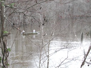
The Waccamaw River is a river, approximately 140 miles (225 km) long, in southeastern North Carolina and eastern South Carolina in the United States. It drains an area of approximately 1,110 square miles (2886 km²) in the coastal plain along the eastern border between the two states into the Atlantic Ocean. Along its upper course, it is a slow-moving, blackwater river surrounded by vast wetlands, passable only by shallow-draft watercraft such as canoe. Along its lower course, it is lined by sandy banks and old plantation houses, providing an important navigation channel with a unique geography, flowing roughly parallel to the coast.

Lucas Vázquez de Ayllón was a Spanish magistrate and explorer who in 1526 established the short-lived San Miguel de Gualdape colony, one of the first European attempts at a settlement in what is now the United States. Ayllón's account of the region inspired a number of later attempts by the Spanish and French governments to colonize the southeastern United States.
The Waccamaw people were an Indigenous people of the Southeastern Woodlands, who lived in villages along the Waccamaw and Pee Dee rivers in North and South Carolina in the 18th century.

The history of the colonial period of South Carolina focuses on the English colonization that created one of the original Thirteen Colonies. Major settlement began after 1651 as the northern half of the British colony of Carolina attracted frontiersmen from Pennsylvania and Virginia, while the southern parts were populated by wealthy English people who set up large plantations dependent on slave labor, for the cultivation of cotton, rice, and indigo.
The Winyaw were a Native American tribe living near Winyah Bay, Black River, and the lower course of the Pee Dee River in South Carolina. The Winyaw people disappeared as a distinct entity after 1720 and are thought to have merged with the Waccamaw.

Robert Francis Withers Allston was the 67th Governor of South Carolina. He was born in Waccamaw, South Carolina.
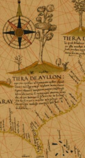
San Miguel de Gualdape is a former Spanish colony in present-day Georgetown County, South Carolina, founded in 1526 by Lucas Vázquez de Ayllón. It was the first European settlement in what became the continental United States, and the third in North America north of Mexico.

Chicora was a legendary Native American kingdom or tribe sought during the 16th century by various European explorers in present-day South Carolina. The legend originated after Spanish slave traders captured an Indian they called Francisco de Chicora in 1521; afterward, they came to treat Francisco's home country as a land of abundant wealth and natural resources. The "Chicora Legend" influenced both the Spanish and the French in their attempts to colonize North America for the next 60 years.
Waccamaw Siouan Indians are one of eight state-recognized tribes in North Carolina. They are also known as the "People of the Fallen Star." Historically Siouan-speaking, they are located predominantly in the southeastern North Carolina counties of Bladen and Columbus. Their congressional representative introduced a failed bill for federal recognition in 1948. North Carolina recognized the group in 1971.
Port Royal Sound is a coastal sound, or inlet of the Atlantic Ocean, located in the Sea Islands region, in Beaufort County in the U.S. state of South Carolina. It is the estuary of several rivers, the largest of which is the Broad River.

The Cusabo or Cosabo were a group of American Indian tribes who lived along the coast of the Atlantic Ocean in what is now South Carolina, approximately between present-day Charleston and south to the Savannah River, at the time of European colonization. English colonists often referred to them as one of the Settlement Indians of South Carolina, tribes who "settled" among the colonists.
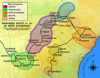
Cofitachequi was a paramount chiefdom founded about 1300 AD and encountered by the Hernando de Soto expedition in South Carolina in April 1540. Cofitachequi was later visited by Juan Pardo during his two expeditions (1566–1568) and by Henry Woodward in 1670. Cofitachequi ceased to exist as a political entity prior to 1701.
Francisco de Chicora was the baptismal name given to a Native American kidnapped in 1521, along with 70 others, from near the mouth of the Pee Dee River by Spanish explorer Francisco Gordillo and slave trader Pedro de Quexos, based in Santo Domingo and the first Europeans to reach the area. From analysis of the account by Peter Martyr, court chronicler, the ethnographer John R. Swanton believed that Chicora was from a Catawban group.

The North Inlet-Winyah Bay National Estuarine Research Reserve, in the U.S. State of South Carolina, features the salt marshes and ocean dominated tidal creeks of the North Inlet Estuary plus the brackish waters and marshes of the adjacent Winyah Bay Estuary. North Inlet is a relatively pristine system in which water and habitat quality are much higher than those in Winyah Bay. As the estuary with the third largest watershed on the east coast, Winyah Bay has been greatly influenced by agriculture, industry and other human activities. More than 90 percent of North Inlet's watershed is in its natural forested state

