Witham First District IDB

Last updated

Witham First District IDB
Pumping Station at Thorpe Tilney Dales - geograph.org.uk - 418646.jpg
Timberland pumping station at Thorpe Tilney Dales, which was superseded by electric pumps, and is open to the public.
Lincolnshire UK location map.svg
Red pog.svg
Witham First District IDB
Location within Lincolnshire
OS grid reference TF187560
Shire county
Region
Country England
Sovereign state United Kingdom
List of places
UK
England
Lincolnshire
53°05′N0°13′W / 53.08°N 0.22°W / 53.08; -0.22 (Witham First District IDB) Coordinates: 53°05′N0°13′W / 53.08°N 0.22°W / 53.08; -0.22 (Witham First District IDB)

Witham First District IDB is an English internal drainage board which was set up under the terms of the Land Drainage Act 1930. The Board inherited the responsibilities of the Witham General Drainage Commissioners, who were first constituted by an Act of Parliament of 1762. They manage the land drainage of an area to the west of the River Witham, between Lincoln and Dogdyke, which includes the valley of the River Slea to above Sleaford.

Contents

The district is divided into a number of compartments, as it is intersected by embanked rivers which cross the area, carrying water from the Car Dyke, which acts as a catchwater drain at the western boundary, to the Witham on its eastern edge. Most of the parishes were enclosed in the late 1700s, by separate Acts of Parliament, and steam-powered drainage was introduced from the 1830s. Steam engines were gradually replaced by oil and diesel engines, and most have since been superseded by electric pumps. The Witham First District IDB maintains thirteen pumping stations and 165 miles (266 km) of drainage channels.

Organisation

The River Witham passes through low-lying land in Lincolnshire, which is susceptible to flooding. In 1762, an Act of Parliament was passed, which created the Witham General Drainage Commissioners, and divided the area into six districts, each with responsibility for land drainage. [1] These were called the Witham First, Second, Third, Fourth, Fifth and Sixth Districts. [2] The First District covered an area of 24,916 acres (10,083 ha), bounded on the north and east by the river, and on the south and west by the Car Dyke, an ancient navigation channel. The Fifth District covered a much smaller area of 5,176 acres (2,095 ha) between Billinghay Skirth and Kyme Eau, the lower part of the River Slea. It became part of the First District in 1953. [1]

There were initially 23 commissioners for the district, one elected by each of the eighteen parishes which formed the First District, and another five from parishes in the Fifth District. Each district also elected some of the 31 General Drainage Commissioners. Seven came from the First District and another two from the Fifth District. The remainder came from the other four similar bodies created by the original Act. [3]

The Land Drainage Act 1930 made provision for the creation of internal drainage boards. The Witham and Steepings Catchment Board, who were responsible for the rivers at the time, proposed the creation of the Witham First District IDB, which took effect from 8 January 1934. In 1951, the Board was restructured to include six extra members, when the Witham Fifth District IBD was abolished, and was effectively amalgamated with the First District. Its area of responsibility was extended in 1968, when parts of fourteen parishes and the Urban District of Sleaford came under its jurisdiction, and the board was again restructured on 7 July 1993, to include representatives from local Councils, as required by the Land Drainage Act of 1991. [3]

Landscape

Witham First District
BSicon uexCONTg.svg
BSicon uCONTg.svg
To Lincoln
BSicon uexSTR.svg
BSicon uSTR.svg
Sincil Dyke + River Witham
BSicon uexSTRq.svg
BSicon uexABZg+r.svg
BSicon uSTR.svg
Sandhill Beck
BSicon uexSTRq.svg
BSicon uxSTRbl.svg
BSicon uSTR.svg
Sandhill Beck PS
BSicon uexSTRq.svg
BSicon uxSTRbl.svg
BSicon uSTR.svg
Heighington PS
BSicon uexSTR.svg
BSicon uSTR.svg
BSicon uexSTR+l.svg
Barlings Eau
BSicon uexSTR+l.svg
BSicon uexSTR+r.svg
BSicon uexSTR.svg
BSicon uWEIRr.svg
BSicon uABZg+r.svg
Old course of R Witham
BSicon uexSTR.svg
BSicon uexFABZgl+l.svg
BSicon uexSTRq.svg
BSicon uexABZg+r.svg
BSicon uSTR.svg
BSicon uSTR.svg
Branston Delph
BSicon uexSTRr.svg
BSicon uexSTR.svg
BSicon uexSTR.svg
BSicon uSTR.svg
BSicon uSTR.svg
Car Dyke
BSicon uexSTR.svg
BSicon uexSTRq.svg
BSicon uxSTRbl.svg
BSicon uLock5.svg
BSicon uSTR.svg
Branston PS + Bardney lock
BSicon uexSTR.svg
BSicon uexSTRl.svg
BSicon uABZg+lxr.svg
BSicon uSTRr.svg
BSicon uexSTR.svg
BSicon uexSTRq.svg
BSicon uSTRbl.svg
Nocton PS
BSicon uexFABZgl+l.svg
BSicon uSTRq.svg
BSicon uFGATEr.svg
BSicon uFABZgr+r.svg
Nocton Delph
BSicon uexSTR.svg
BSicon uexSTRq.svg
BSicon uSTRbl.svg
Metheringham PS
BSicon uexFABZgl+l.svg
BSicon uSTRq.svg
BSicon uFGATEr.svg
BSicon uFABZgr+r.svg
Metheringham Delph
BSicon uexSTR.svg
BSicon uexSTRq.svg
BSicon uSTRbl.svg
Blankney PS
BSicon uexFABZgl+l.svg
BSicon uSTRq.svg
BSicon uFGATEr.svg
BSicon uFABZgr+r.svg
Timberland Delph
BSicon uexSTR.svg
BSicon uexSTRq.svg
BSicon uSTRbl.svg
Engine Drain + Timberland PS
BSicon uexSTR.svg
BSicon uSTRl.svg
BSicon uSTR+r.svg
BSicon uexSTR.svg
BSicon uSTR+l.svg
BSicon uFGATEr.svg
BSicon uFABZgr+r.svg
Billinghay Skirth
BSicon uexSTR.svg
BSicon uexSTRl.svg
BSicon uSTRbl.svg
BSicon uSTR.svg
Billinghay PS
BSicon uexSTRl.svg
BSicon uxWEIRfr.svg
BSicon ueABZgr.svg
BSicon uSTR.svg
Car Dyke sluice
BSicon uexSTR+r.svg
BSicon uexSTRl.svg
BSicon uSTRbl.svg
BSicon uSTR.svg
Ringmoor PS
BSicon uexSTRq.svg
BSicon uxHSTRbu.svg
BSicon uexSTRq.svg
BSicon uexABZgr.svg
BSicon uSTR.svg
Digby Drain + PS
BSicon uexSTRq.svg
BSicon uxHSTRbm.svg
BSicon uexSTRq.svg
BSicon uexSTRr.svg
BSicon uSTR.svg
Farroway Drain + PS
BSicon uSTR+l.svg
BSicon uFGATEr.svg
BSicon uFABZgr+r.svg
Kyme Eau
BSicon uexSTRl.svg
BSicon uSTRbl.svg
BSicon uSTR.svg
Chapel Hill PS
BSicon uCONTgq.svg
BSicon uSTR+r.svg
BSicon uLock3.svg
BSicon uSTR.svg
To Sleaford
BSicon uABZl+xl.svg
BSicon uSTRr.svg
BSicon uSTR.svg
BSicon uexCONTf.svg
BSicon uSTR.svg
Car Dyke + River Witham
BSicon uCONTf.svg
To Boston

The district is effectively broken up into compartments by a number of rivers, acting as highland carriers, whose water level is normally above that of the surrounding land, but flooding is prevented by flood banks. The main river is the Witham, running broadly north to south through the district, but there is also the Car Dyke, which runs parallel to the Witham and further to the west, acting as a catchwater drain for water which would otherwise flow into the low-lying region. Between them, running broadly west to east, are seven other channels. Beginning in the north, below Lincoln, and working south towards Boston, these are Sandhill Beck, Branston Delph, Nocton Delph, Metheringham Delph, Timberland Delph, Billinghay Skirth, and Kyme Eau, which is another name for the lower part of the River Slea. The water level of most of these is normally the same as that of the Witham, but they are fitted with pointed doors where they meet, which are designed to close by gravity if water levels in the Witham rise significantly. They are all classified as main rivers, [4] and are therefore managed by the Environment Agency. The total length of rivers passing through the district or adjacent to it is 94 miles (151 km), and they are restrained by 125 miles (201 km) of banks. [5]

The area managed by the First District IDB lies to the east of the Lincoln Edge, a limestone escarpment which is a prominent feature of Lincolnshire. Several small streams are fed by springs on its dip slope, and the Car Dyke intercepts these. It connects with the heads of the Delphs, discharging water from the streams into them by gravity. At Billinghay Skirth, a small sluice connects the two waterways. [6] The district covers an area of 60.82 square miles (157.5 km2), of which all but 1.03 square miles (2.7 km2) is agricultural land. The catchment for the district includes an additional 2.88 square miles (7.5 km2). Within the district, 11.8 acres (4.8 ha) are a designated Site of Special Scientific Interest, and the 74 acres (30 ha) of Metheringham Delph are a nature reserve. [5]

Development

Before the eighteenth century, the district was open common land, where those living in adjoining parishes had grazing rights. The fens were used as summer pasture, as they were frequently flooded for most of the winter period. Efforts to improve the Witham by straightening the channel, making it deeper, and constructing the Grand Sluice to the north of Boston did not prevent flooding. Following the passing of the 1762 Act, the structure was in place to address these issues. The commissioners had responsibility for the district, but also powers to collect rates, to ensure that the drainage works could be built and maintained. [7]

For administrative purposes, the district was divided up into a number of sub-districts, based on parish boundaries and enclosure acts. A series of Acts of Parliament, passed between 1779 and 1840 authorised improvements to these sub-districts, [3] and initial attempts to drain the land used wind-pumps. The work had significant effects on land values. Arthur Young, writing in 1799, noted that land which was previously let at one shilling and sixpence (7.5p) per acre (0.4 ha), was now valued at between eleven shillings (55p) and seventeen shillings (85p) per acre. A Commissioner called Mr. Parkinson estimated that the rental value of 43,407 acres (17,566 ha) had risen from £5,982 to £42,375. This was "effected by a moderate embankment and the erection of windmills for throwing out the superfluous water." [7]

The science of Fen drainage was not well understood when the first enclosure acts were passed, and it was thought that flooding might be worse if the embankments were placed too close to the river. Consequently, the Dales Head Dyke was constructed, about 1 mile (1.6 km) to the west of the Witham, and the land between it and the river was used as washland, and was flooded for up to nine months each year. By 1797, the process was better understood, and an Act of Parliament authorised the reclaiming of 2,800 acres (1,100 ha) of washland, by moving the banks much closer to the river, and extending the banks at the sides of several fens to join the repositioned flood bank. A drainage engine was to be moved from Blankney Fen to Martin Fen, and the documents were to be stored in a chest in Timberland Church, where they could be viewed on payment of one shilling (5p). [8]

Pumping engines

By the 1840s, several steam-powered pumping stations had been built, to pump water from the drains into the river more efficiently. Early installations, such as that at Dunston and Metheringham, consisted of a beam engine driving a scoop wheel. By 1913, this had been replaced by a steam engine driving a pump made by Smithdale, which was itself replaced by a 100 hp (75 kW) oil engine and a Gwynnes Limited pump between 1933 and 1943. Two electric motors with 24-inch (61 cm) Gwynnes pumps replaced them in 1952, located at a different site, and in 1990, a submersible electric pump was installed at a third site. [9]

An Act to enclose the fen land in the parish of Branston was obtained in 1765, and another for the parish of Potterhanworth in 1774. This also gave the Commissioners powers to build banks, engines and sluices. A third Act was obtained in 1789, which authorised the embanking of 5,850 acres (2,370 ha) in Nocton, Potterhanworth and Branston. It included provision for enlarging the Car Dyke, and raising its eastern bank. In 1812, the Witham was straightened by cutting the South Delph, and the part of Branston parish which was now on the east bank of the Witham became known as Branston Island. Drainage was by a wind engine, but this was not adequate for the job, and in 1832 a further Act was obtained to allow a steam engine to be used. The Witham Commissioners thought that the extra volume of water and the speed with which it would be pumped would damage the river banks, and sought an injunction to prevent the use of steam power. This was refused, and a 40 hp (30 kW) engine was installed. Much of the fen was flooded in 1862, when a 156-foot (48 m) section of the South Delph flood bank failed. [10] The Great Northern Railway Company, who owned the Witham at this time, argued that although the river was their responsibility, the bank was not, as it was not specifically mentioned in the 1812 Act. However, Lincoln Assizes decided differently, and awarded damages to those affected by the flood. [11] The engine was replaced by a Marshall steam engine and 36-inch (91 cm) Gwynnes pump sometime in the early twentieth century, which was itself replaced by a Ruston oil engine in 1940. An Allen-Gwynnes electric motor driving a 24-inch (61 cm) axial flow pump was installed in 1956. [12]

The Timberland and Thorpe fens cover an area of 2,850 acres (11.5 km2) and were enclosed in 1785. An Act of Parliament obtained in 1839 authorised drainage, and the first Timberland pumping station was constructed in that year. A 26.5-foot (8.1 m) scoop wheel was driven by a 30 hp (22 kW) beam engine, discharging water into the Witham. A high-pressure condensing beam engine replaced it in 1881, which was coupled to a 48-inch (120 cm) centrifugal pump. Further upgrades included a Foster tandem horizontal steam engine in 1924 and a Ruston diesel engine in 1938. When the equipment was replaced by electric pumps in 1976, the diesel engine and Gwynnes pump were retained, and are open to the public during the summer. [13]

Billinghay South Fen was enclosed in 1777, and covered 4,526 acres (18.32 km2). The first beam engine, which was manufactured by Green Atkinson, and its scoop wheel, lasted from 1841 until 1935. It was then replaced by two diesel engines with Gwynnes pumps. The building was bombed by enemy aircraft in 1941, during the Second World War, and five members of the Richardson family were killed. Richardson was the engine driver at the time. After the incident many redundant chimneys were demolished, as they were prominent targets for enemy aircraft. By 1977 pumping was performed by two electric-powered 30-inch (76 cm) pumps manufactured by Allen-Gwynnes. [14]

Pumping stations

The table shows the locations of the IDB pumping stations, with the number of pumps in 2008, and the maximum pumped flow in megalitres per day (Mld) [15] (1 Mld is 0.233 million gallons per day).

Map this section's coordinates using: OpenStreetMap  
Download coordinates as: KML

See also

Witham Navigable Drains
Witham Third District IDB
Upper Witham IDB

Bibliography

Related Research Articles

River Witham River in eastern England

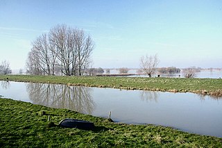
The River Witham is a river almost entirely in the county of Lincolnshire in the east of England. It rises south of Grantham close to South Witham at SK8818, passes through the centre of Grantham, passes Lincoln at SK9771 and at Boston, TF3244, flows into The Haven, a tidal arm of The Wash, near RSPB Frampton Marsh. The name "Witham" seems to be extremely old and of unknown origin. Archaeological and documentary evidence shows the importance of the Witham as a navigable river from the Iron Age onwards. From Roman times it was navigable to Lincoln, from where the Fossdyke was constructed to link it to the River Trent. The mouth of the river moved in 1014 following severe flooding, and Boston became important as a port.

Old Bedford River Watercourse in Cambridgeshire, England

The Old Bedford River is an artificial, partial diversion of the waters of the River Great Ouse in the Fens of Cambridgeshire, England. It was named after the fourth Earl of Bedford who contracted with the local Commission of Sewers to drain the Great Level of the Fens beginning in 1630. It provided a steeper and shorter path for the waters of the Great Ouse, and was embanked to prevent them flooding the low ground of the South Fens. Throughout the project, the Earl and his Adventurers faced disruption from those who were opposed to drainage schemes. The project was deemed to have succeeded in draining the fens in 1637, but that decision was reversed in 1638. After a lull during the English Civil War, when much of the work was damaged, the Dutch engineer Cornelius Vermuyden worked with William Russell, the fifth Earl of Bedford to complete the drainage. Disruption and unrest continued while the work was carried out, resulting in the Adventurers employing armed guards. A second river, the New Bedford River, was cut parallel to the first channel, which then became the Old Bedford River. At some point, the Old Bedford River was split into two parts, when the upper section was diverted into the River Delph at Welches Dam, and the lower section was joined to the Counter Drain. Both parts retain the name, but are not connected to each other. The area between the two Bedford rivers acts as a large washland, which holds floodwater when the river channels cannot cope with the volume of water in them.

New Bedford River Watercourse in Cambridgeshire, England

The New Bedford River, also known as the Hundred Foot Drain because of the distance between the tops of the two embankments on either side of the river, is a navigable man-made cut-off or by-pass channel of the River Great Ouse in the Fens of Cambridgeshire, England. It provides an almost straight channel between Earith and Denver Sluices. It is tidal, with reverse tidal flow being clearly visible at Welney, some 19 miles (31 km) from the sea.

South Forty-Foot Drain Drainage canal in eastern England

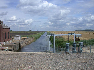
The South Forty-Foot Drain, also known as the Black Sluice Navigation, is the main channel for the land-drainage of the Black Sluice Level in the Lincolnshire Fens. It lies in eastern England between Guthram Gowt and the Black Sluice pumping station on The Haven, at Boston. The Drain has its origins in the 1630s, when the first scheme to make the Fen land available for agriculture was carried out by the Earl of Lindsey, and has been steadily improved since then. Water drained from the land entered The Haven by gravity at certain states of the tide until 1946, when the Black Sluice pumping station was commissioned.

Car Dyke Ditch in the Fens in eastern England

The Car Dyke was, and to a large extent still is, an 85-mile (137 km) long ditch which runs along the western edge of the Fens in eastern England. It is generally accepted as being of Roman age and, for many centuries, to have been taken as marking the western edge of the Fens. There, the consensus begins to break down.

Bourne Eau River in Lincolnshire, England

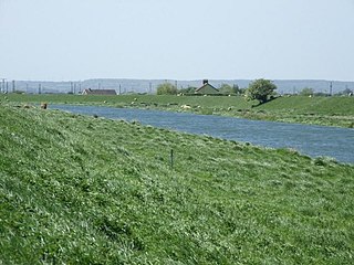
Bourne Eau is a short river which rises from an artesian spring in the town of Bourne in Lincolnshire, England, and flows in an easterly direction to join the River Glen at Tongue End. Within the town, it once powered three water mills, one of which is now a heritage centre. At Eastgate, it becomes much wider as it was navigable in the 18th and 19th centuries, and this was the location of the terminal basin. Below the town it is an embanked river, as its normal level is higher than that of the surrounding Fens. Navigation ceased in the 1860s and the river now forms an important part of the drainage system that enables the surrounding fen land to be used for agriculture.

Hatfield Chase Human settlement in England

Hatfield Chase is a low-lying area in South Yorkshire and North Lincolnshire, England, which was often flooded. It was a royal hunting ground until Charles I appointed the Dutch engineer Cornelius Vermuyden to drain it in 1626. The work involved the re-routing of the Rivers Don, Idle and Torne, and the construction of drainage channels. It was not wholly successful, but changed the whole nature of a wide swathe of land including the Isle of Axholme and caused legal disputes for the rest of the century. The civil engineer John Smeaton looked at the problem of wintertime flooding in the 1760s, and some remedial work was carried out.

Burnt Fen Human settlement in England

Burnt Fen is an area of low-lying land crossed by the A1101 road between Littleport in Cambridgeshire and Mildenhall in Suffolk, England. It is surrounded on three sides by rivers, and consists of prime agricultural land, with sparse settlement. It is dependent on pumped drainage to prevent it from flooding.

Barlings Eau River in Lincolnshire, England

Barlings Eau is a small river near Barlings, Lincolnshire, England. It is a tributary of the River Witham, joining it near Short Ferry. It acts as the central spine for a number of other small rivers, which drain the low-lying land to either side. Most of its course is within the area managed by the Witham Third District IDB, an Internal Drainage Board responsible for land drainage. One of their pumping stations is on the banks of the river.

Middle Level Commissioners

The Middle Level Commissioners are a land drainage authority in eastern England. The body was formed in 1862, undertaking the main water level management function within the Middle Level following the breakup of the former Bedford Level Corporation.

Witham Navigable Drains

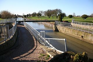
The Witham Navigable Drains are located in Lincolnshire, England, and are part of a much larger drainage system managed by the Witham Fourth District Internal Drainage Board. The Witham Fourth District comprises the East Fen and West Fen, to the north of Boston, which together cover an area of 97 square miles (250 km2). In total there are over 438 miles (705 km) of drainage ditches, of which under 60 miles (97 km) are navigable. Navigation is normally only possible in the summer months, as the drains are maintained at a lower level in winter, and are subject to sudden changes in level as a result of their primary drainage function, which can leave boats stranded. Access to the drains is from the River Witham at Anton's Gowt Lock.

Pode Hole Small village 2 mi to the west of the centre of Spalding, Lincolnshire, England

Pode Hole is a small village 2 miles (3.2 km) to the west of the centre of Spalding, Lincolnshire, England. The village lies at the confluence of several drainage channels, where two pumping stations discharge water into Vernatt's Drain from land in Deeping Fen to the South and West. Water from Pinchbeck South Fen to the North is also lifted into Vernatt's Drain. The village arose to service the pumping stations.

Guthram Gowt Small settlement in the South Holland district of Lincolnshire, England

Guthram Gowt is a small settlement in the South Holland district of Lincolnshire, England. It is situated 5 miles (8 km) both east from Bourne and west from Spalding, and at a bend in the River Glen.

Dogdyke Pumping Station

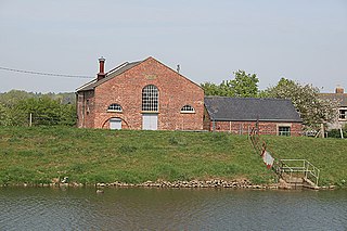
The Dogdyke Engine is a drainage engine near Tattershall, Lincolnshire, in England. The drainage of 2,500 acres (1,012 ha) of land around Tattershall was authorised in 1796, and came under the control of the Witham Third District commissioners in 1844

Dogdyke Hamlet in the North Kesteven district of Lincolnshire, England

Dogdyke is a hamlet in the North Kesteven district of Lincolnshire, England. It is situated approximately 2 miles (3 km) south from Tattershall, and at the confluence of the Rivers Bain and Witham, and close to where the River Slea joins the Witham.

Deeping Fen Human settlement in England

Deeping Fen is a low-lying area in the South Holland district of Lincolnshire, England, which covers approximately 47 square miles (120 km2). It is bounded by the River Welland and the River Glen, and is extensively drained, but the efficient drainage of the land exercised the minds of several of the great civil engineers of the 17th and 18th centuries.

South Holland IDB Human settlement in England

South Holland IDB is an English internal drainage board set up under the terms of the Land Drainage Act 1930. It has responsibility for the land drainage of 148.43 square miles (384.4 km2) of low-lying land in South Lincolnshire. It is unusual as its catchment area is the same as the area of the drainage district, and so it does not have to deal with water flowing into the area from surrounding higher ground. No major rivers flow through the area, although the district is bounded by the River Welland to the west and the River Nene to the east.

Witham Third District IDB Human settlement in England

Witham Third District IDB is an English internal drainage board set up under the terms of the Land Drainage Act 1930. The Board inherited the responsibilities of the Witham General Drainage Commissioners, who were first constituted by an Act of Parliament of 1762. They manage the land drainage of an area to the north and east of the River Witham, between Lincoln and Dogdyke, which includes the valley of the River Bain to above Hemingby, and the valleys of Barlings Eau and most of its tributaries, to the north east of Lincoln.

River Till, Lincolnshire River in Lincolnshire, England

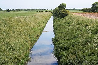
The River Till is a river in the county of Lincolnshire in England and is ultimately a tributary of the River Witham. Its upper reaches drain the land east of Gainsborough. The middle section is embanked, as the water level is higher than that of the surrounding land, and pumping stations pump water from low level drainage ditches into the river. Its lower reaches from the hamlet of Odder near Saxilby into the city of Lincoln were canalised, possibly as early as Roman times, as part of the Foss Dyke.

Upper Witham IDB Human settlement in England

The Upper Witham IDB is an English Internal Drainage Board responsible for land drainage and the management of flood risk for an area to the west of the Lincolnshire city of Lincoln, broadly following the valleys of the upper River Witham, the River Till and the course of the Fossdyke Navigation.

References

  1. 1 2 Hinde 2006 , pp. 168–169
  2. IDB map
  3. 1 2 3 IDB 2003
  4. Lobley 2009 , p. v (pdf:15)
  5. 1 2 Elkington 2009 Sect:3
  6. Lobley 2009 , p. 8 (pdf:26)
  7. 1 2 Wheeler & Batty 1896 , p. 182
  8. Wheeler & Batty 1896 , pp. 183–184
  9. Hinde 2006 , pp. 170–171
  10. Wheeler & Batty 1896 , pp. 185–186
  11. Wheeler & Batty 1896 , pp. 170
  12. Hinde 2006 , p. 169
  13. Hinde 2006 , pp. 171–172
  14. Hinde 2006 , p. 172
  15. Lobley 2009 , p. 118