
Tyne and Wear is ceremonial county in North East England. It borders Northumberland to the north and County Durham to the south, and the largest settlement is the city of Newcastle-upon-Tyne.

Washington is a town in the City of Sunderland district of Tyne and Wear, England. Historically part of County Durham, it is the ancestral settlement of the Washington family, from which George Washington descended.

Sunderland is a port city in Tyne and Wear, England. It is the City of Sunderland's administrative centre and in the historic county of Durham. The city is 10 miles (16 km) from Newcastle-upon-Tyne and is on the River Wear's mouth to the North Sea. The river also flows through Durham roughly 12 miles (19 km) south-west of Sunderland City Centre. It is the only other city in the county and the second largest settlement in the North East after Newcastle upon Tyne.

Gateshead is a town in the Metropolitan Borough of Gateshead in Tyne and Wear, England. It is on the River Tyne's southern bank, opposite Newcastle to which it is joined by seven bridges. The town contains the Millennium Bridge, The Sage, and the Baltic Centre for Contemporary Art, and has on its outskirts the twenty metre tall Angel of the North sculpture.
South Tyneside is a metropolitan borough in the metropolitan county of Tyne and Wear, North East England.
North Tyneside is a metropolitan borough in the metropolitan county of Tyne and Wear, England. It forms part of the greater Tyneside conurbation. North Tyneside Council is headquartered at Cobalt Park, Wallsend.

The Tyne and Wear Metro is an overground and underground light rail rapid transit system serving Newcastle upon Tyne, Gateshead, North Tyneside, South Tyneside, and the City of Sunderland. The network opened in stages from August 1980 and now serves a total of 60 stations, with two lines covering 77.5 km (48.2 mi) of track. The Metro can be accessed from a mixture of under ground and above ground stations. It has been described as the "first modern light rail system in the United Kingdom". The system is currently owned and operated by the Tyne and Wear Passenger Transport Executive, thus is fully under public ownership and operation.

Fulwell is an affluent area and former civil parish in the City of Sunderland. The parish was abolished in 1928 as a result of the Sunderland Corporation Act 1927, and the area incorporated into the former County Borough of Sunderland. It borders Seaburn, Southwick, Monkwearmouth, and Roker, and the district border between Sunderland and South Tyneside. Fulwell ward, including South Bents and Seaburn, is the least socially deprived of the city's 25 wards.

Tyne and Wear PTE, branded as Nexus, is an executive body of the North East Joint Transport Committee and is best known for owning and operating the Tyne and Wear Metro. It replaced the Tyneside PTE on 1 April 1974.
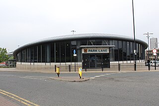
Park Lane is a Tyne and Wear Metro station, serving the port city of Sunderland in Tyne and Wear, England. It joined the network on 28 April 2002, following the opening of the extension from Pelaw to South Hylton.

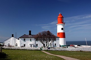
Cleadon is a suburban village in South Tyneside in the North East of England. Prior to the creation of Tyne and Wear in 1974 by the Local Government Act 1972, the village was part of the historic County Durham. In the 2011 UK Census the population of the South Tyneside ward of Cleadon and East Boldon was 8,427. Nearby population centres include East Boldon, Whitburn, and Jarrow. The village is located approximately 5 miles (8 km) from the city of Sunderland and 5 miles from the town South Shields. It is situated on the south west of Cleadon Hills, an example of a Magnesian Limestone grassland home to a number of regionally and nationally rare species.
Southwick is a former village and now a suburb on the north banks of the River Wear in the city of Sunderland in the county of Tyne and Wear, historically in County Durham. From 1894 to 1928, Southwick was administered by the Southwick-on-Wear Urban District Council, before being absorbed by Sunderland.

Tyne and Wear Fire and Rescue Service, formerly known as the Tyne and Wear Metropolitan Fire Brigade, is the fire and rescue service (FRS) for the metropolitan boroughs of Newcastle Upon Tyne, Gateshead, North Tyneside, South Tyneside and Sunderland, serving a population of 1.14 million people across an area of 208 square miles (540 km2). Tyne and Wear Fire and Rescue Authority is responsible for the running of the service, as well as the publication of performance indicators in accordance with its legal obligations. In April 2017, Chris Lowther was appointed chief fire officer.

Springwell Village is a village in the City of Sunderland, bordering Gateshead, approximately 7.6 miles (12.2 km) from Newcastle upon Tyne, 9 miles (14 km) from Sunderland, and 13 miles (21 km) from Durham. In 2011, Census data for the City of Sunderland ward of Washington West recorded a total population of 11,833.

Tyne and Wear is a metropolitan area covering the cities of Newcastle upon Tyne and Sunderland, as well as North and South Tyneside, Gateshead and Washington.
Seaburn Dene is a northern suburb of Sunderland, England, located about one mile inland from the North Sea, near the boundary with South Tyneside.
Carley Hill is a suburb of Sunderland, Tyne and Wear in North East England.
