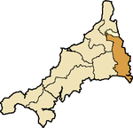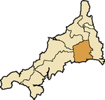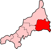
Caradon was a local government district in Cornwall, United Kingdom. It contained five towns: Callington, Liskeard, Looe, Saltash and Torpoint, and over 80 villages and hamlets within 41 civil parishes. Its District Council was based in Liskeard 50.453°N 4.465°W.

West Country English is a group of English language varieties and accents used by much of the native population of South West England, the area sometimes popularly known as the West Country.

Godrevy is an area on the eastern side of St Ives Bay, west Cornwall, England, United Kingdom, which faces the Atlantic Ocean. It is popular with both the surfing community and walkers. It is part owned by the National Trust, and offshore on Godrevy Island is a lighthouse maintained by Trinity House which is said to be the inspiration for Virginia Woolf's novel To the Lighthouse. Godrevy lies within the Cornwall Area of Outstanding Natural Beauty (AONB) and the South West Coast Path runs around the whole promontory. There are several public car parks on the western side where the National Trust owns and operates a café.
The history of Cornwall goes back to the Paleolithic, but in this period Cornwall only had sporadic visits by groups of humans. Continuous occupation started around 10,000 years ago after the end of the last ice age. When recorded history started in the first century BCE, the spoken language was Common Brittonic, and that would develop into Southwestern Brittonic and then the Cornish language. Cornwall was part of the territory of the tribe of the Dumnonii that included modern-day Devon and parts of Somerset. After a period of Roman rule, Cornwall reverted to rule by independent Romano-British leaders and continued to have a close relationship with Brittany and Wales as well as southern Ireland, which neighboured across the Celtic Sea. After the collapse of Dumnonia, the remaining territory of Cornwall came into conflict with neighbouring Wessex.

The Diocese of Truro is a Church of England diocese in the Province of Canterbury which covers Cornwall, the Isles of Scilly and a small part of Devon. The bishop's seat is at Truro Cathedral.

The hundreds of Cornwall were administrative divisions (hundreds) into which Cornwall, the present day administrative county of England, in the United Kingdom, was divided between c. 925 and 1894, when they were replaced with local government districts.

Ludgvan is a civil parish and village in Cornwall, England, UK, 2+1⁄2 miles (4.0 km) northeast of Penzance. Ludgvan village is split between Churchtown, on the hill, and Lower Quarter to the east, adjoining Crowlas. For the purposes of local government, Ludgvan elects a parish council every four years; the town elects a member to Cornwall Council under the Ludgvan division.
Cornish bagpipes are the forms of bagpipes once common in Cornwall in the 19th century. Bagpipes and pipes are mentioned in Cornish documentary sources from c.1150 to 1830 and bagpipes are present in Cornish iconography from the 15th and 16th centuries.

The hundred of Kerrier was the name of one of ten ancient administrative shires of Cornwall, in the United Kingdom. Kerrier is thought by Charles Thomas to be derived from an obsolete name of Castle Pencaire on Tregonning Hill, Breage. It is likely that an even earlier name for the district was Predannack which has been displaced by the Lizard Peninsula as a geographical name.
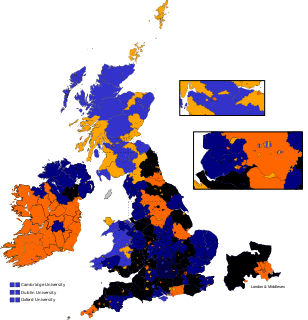
East Cornwall was a county constituency in the House of Commons of the Parliament of the United Kingdom. It elected two Members of Parliament (MPs) by the bloc vote system of election.
Linkinhorne is a civil parish and village in southeast Cornwall, England, United Kingdom. The village itself is situated at grid reference SX 320 736 and is approximately four miles (6.5 km) northwest of Callington and seven miles (11 km) south of Launceston. The parish population at the 2011 census including Downgate was 1,541
This timeline summarizes significant events in the History of Cornwall

St Stephens by Launceston Rural is a civil parish in the east of Cornwall, England, United Kingdom. It is in the Registration district of Launceston. The population of the parish in the 2001 census was 312, increasing to 360 and including Dutson at the 2011 census. The former parish of St Stephens by Launceston was abolished in 1894: St Stephens by Launceston Urban became part of the town of Launceston, while St Stephens by Launceston Rural became part of Launceston Rural District.

South Petherwin is a village and civil parish in east Cornwall, England, United Kingdom. It is in the Registration District of Launceston. The civil parish is bounded to the north by the Launceston parishes of St Thomas and St Mary Magdalene, to the east by Lawhitton and Lezant parishes and to the west by Trewen parish. The population of the parish in the 2001 census was 932. The district falls in the Altarnun electoral ward but the population of the civil parish at the 2011 Census was almost unchanged at 931.
Dobwalls and Trewidland is a civil parish in south-east Cornwall, England, United Kingdom.

St Martin-by-Looe is a coastal civil parish in south Cornwall, England, United Kingdom. The parish is immediately east of the town and parish of Looe, seven miles (11 km) south of Liskeard. The parish is in the Liskeard Registration District and the population in the 2001 census was 321, which had increased to 429 at the 2011 census.
South West 1 West is an English, level six, rugby union league for clubs based in the south-west of England; mainly Bristol, Cornwall, Devon, Gloucestershire and Somerset. It was originally a single division known as South West 2 but in 1996 the division was split into two regional leagues - South West 1 West and South West 1 East.

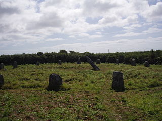
Lammana Priory was a priory on Looe Island in Cornwall, UK, consisting of two Benedictine monks until 1289. It was owned by Glastonbury Abbey and the property was sold in 1289 to a local landowner.

Launceston is a town, ancient borough, and civil parish in Cornwall, England, United Kingdom. It is 1 mile (1.6 km) west of the middle stage of the River Tamar, which constitutes almost the entire border between Cornwall and Devon. The landscape of the town is generally steep particularly at a sharp south-western knoll topped by Launceston Castle. These gradients fall down to the River Kensey and smaller tributaries.
Presented below is an alphabetical index of articles related to Cornwall: