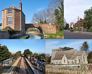
Stroud is a market town and civil parish in Gloucestershire, England. It is the main town in Stroud District. The town's population was 13,500 in 2021.

Nailsworth is a town and civil parish in the Stroud District in Gloucestershire, England, lying in one of the Stroud Valleys in the Cotswolds, on the A46 road, 4 miles (6.4 km) south of Stroud and about 25 miles (40 km) north-east of Bristol and Bath. The parish had a population of 5,794 at the 2011 census.
Fairford is a market town in Gloucestershire, England. The town lies in the Cotswold hills on the River Coln, 6 miles (9.7 km) east of Cirencester, 4 miles (6.4 km) west of Lechlade and 9 miles (14 km) north of Swindon. Nearby are RAF Fairford and the Cotswold Water Park.
Allestree is a suburb and ward of the city of Derby, a unitary authority area, in Derbyshire, England. It is the northernmost ward and is on the A6 road, about 2 miles (3 km) north of Derby city centre. It is bordered by the district of Amber Valley along its western and northern edges and Erewash in its north-east corner. To the south it borders the ward of Mackworth and to the east the ward of Darley Abbey.

Winterbourne Abbas is a village and civil parish in south west Dorset, England, situated in a valley on the A35 road 5 miles (8.0 km) west of Dorchester. In the 2011 census the parish had a population of 355.
King's Stanley is a civil parish and village in Gloucestershire, England, to the south of Stonehouse and southwest of the town of Stroud.
Stonehouse is a town in the Stroud District of Gloucestershire in southwestern England.
Esh is a village and civil parish situated around five miles north-west of Durham in County Durham, England. The central area of the village contains a stone cross, which probably replaced a former market cross. This is locally known as St Cuthberts Cross and bears the inscription I. H. S., and the date 1687. Esh is a rural village, nestled between a number of working farms; it has two primary schools, a pub and two churches, St Michael and All Angels and St. Michael's.

Stroud is a constituency represented in the House of Commons of the UK Parliament. It is held by Siobhan Baillie of the Conservative Party. Formerly a safe Conservative seat, Stroud has been a marginal seat since 1997, changing hands four times in seven elections.
Ashurst is a village in the New Forest district of Hampshire, England, which together with Colbury hamlet makes the parish of Ashurst and Colbury. Ashurst is on the A35 road near the Southampton conurbation. According to the 2001 census the parish had a population of 2,011, increasing to 2,093 at the 2011 Census. The parish is on the edge of the designated New Forest National Park area. The village has a campsite, some shops and a railway station. The parish is bounded to the west by Netley Marsh parish and the Bartley Water, to the north by the A326 road and Totton and Eling, and to the south by Denny Lodge parish in the New Forest.

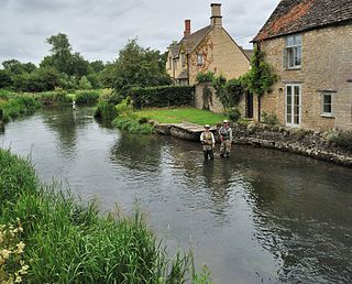
The Five Valleys are a group of valleys in Gloucestershire, England, which converge on the town of Stroud at the western edge of the Cotswolds. The Five Valleys are notable both for the landscape, which attracts visitors, and their role in industrial development of Britain starting with the wool trade in the 11th century, and developing through cloth manufacturing in the 18th century. Despite very poor roads, the use of the rivers and streams in developing links to other centres, via, for example the Thames and Severn Canal, helped the Five Valleys to prosper.
Walberton is a village and civil parish in the Arun District of West Sussex, England, 5 miles (8 km) north-west of Littlehampton, and south of the A27 road. The land rises from 33–115 feet (10–35 m) above sea level, a quarter of the height of Nore Hill, the nearest foothill of the South Downs, which is to the north of the parish. The parish includes the smaller village of Binsted to the east and the larger neighbourhood of Fontwell, less than two-thirds of a mile (1 km) to the north-west. Walberton has a medieval church next to its clustered centre. Binsted's medieval church retains an original setting of village houses dispersed over farm fields.

Gotherington is a small village north of Bishops Cleeve in Gloucestershire, England. It is surrounded on the north by the villages of Woolstone and Oxenton, and to the south by Woodmancote and Bishop's Cleeve, a very large urban village. Gotherington has a population of around 1,200, while its neighbour, Bishops Cleeve, has a population of 15,000. The populations reduced at the 2011 census to 995 for Gotherington.
Rodborough is a large village and civil parish in the district of Stroud, Gloucestershire, in South West England. It is directly south of the town of Stroud, north of the town of Nailsworth and north-west of the town of Minchinhampton. The parish includes the settlements of Bagpath, Butterrow, Kingscourt, Lightpill and Rooksmoor, and is adjacent to the Stroud suburb of Dudbridge. The population taken at the 2011 census was 5,334.

Reed is a small village and civil parish in North Hertfordshire. It is situated on a chalk ridge, approximately 3 miles (4.8 km) south of the market town of Royston. The Prime Meridian passes just to the east of the village, between Reed and Barkway. The modern A10 road passes just to the west of the village. The population of the parish was 310 at the time of the 2011 census.

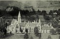
A former Convent of Poor Clares is located in Woodchester, near Stroud in Gloucestershire. The convent was home to nuns of the Poor Clares order from 1850 to 2011.

Edvin Loach and Saltmarshe is a civil parish in north-east Herefordshire, England, and is approximately 15 miles (24 km) north-east from the city and county town of Hereford. The nearest town is Bromyard, 2.5 miles (4 km) to the south-west. Within the parish is a George Gilbert Scott built parish church in the virtually depopulated settlement of Edvin Loach, and the repurposed site of the demolished Saltmarshe Castle.