
Abbots Ripton is a village and civil parish in Cambridgeshire, England. Abbots Ripton is situated within Huntingdonshire which is a non-metropolitan district of Cambridgeshire as well as being an historic county of England. Abbots Ripton lies approximately 4 miles (6 km) north of Huntingdon on the B1090.

Wood Walton is a village and civil parish in Cambridgeshire, England. Wood Walton lies approximately 6 miles (10 km) north of Huntingdon and just east of the A1. Wood Walton is situated within Huntingdonshire which is a non-metropolitan district of Cambridgeshire as well as being a historic county of England.
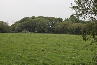
Great Raveley and Little Raveley are villages near Upwood south of Ramsey. They are located in Huntingdonshire, England, 3½ miles south-west of Ramsey. The population is shown in the civil parish of Upwood and the Raveleys.
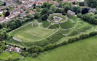
Castle Acre Castle and town walls are a set of ruined medieval defences built in the village of Castle Acre, Norfolk. The castle was built soon after the Norman Conquest by William de Warenne, the Earl of Surrey, at the intersection of the River Nar and the Peddars Way. William constructed a motte-and-bailey castle during the 1070s, protected by large earthwork ramparts, with a large country house in the centre of the motte. Soon after, a small community of Cluniac monks were given the castle's chapel in the outer bailey; under William, the second earl, the order was given land and estates to establish Castle Acre Priory alongside the castle. A deer park was created nearby for hunting.
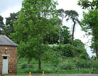
Bury Mount Motte is the remains of an earthwork motte and bailey fortification or ancient castle, and has been designated a Scheduled Ancient Monument. The Motte probably dates back to the 11th Century when it was a Norman fortification but over time was subject to neglect.

Ashton Keynes Castle was in the village of Ashton Keynes, near to the town of Cricklade in Wiltshire, England. It is also known as Hall's Close, while locals call it The Battlefield. The scheduled monument consists of a ringwork and bailey 100 metres (330 ft) west of Kentend Farm.

Aslockton Castle is a ruined fortification, a motte-and-bailey castle, in the village of Aslockton, Nottinghamshire. The original name of the settlement was Aslachetone, which suggests a possible Norse origin; it was mentioned in the Domesday Book of 1086 where it was described as a large settlement.

Castlethorpe Castle stood in the village of Castlethorpe, to the north of Milton Keynes, Buckinghamshire.

Deddington Castle is an extensive earthwork in the village of Deddington, Oxfordshire, all that remains of an eleventh century motte-and-bailey castle, with only the earth ramparts and mound now visible.

Haughley Castle was a medieval castle situated in the village of Haughley, some 4 kilometres (2.5 mi) north-west of the town of Stowmarket, Suffolk. Prominent historians such as J. Wall consider it "the most perfect earthwork of this type in the county," whilst R. Allen Brown has described it as "one of the most important" castle sites in East Anglia.
Huntingdon Castle was situated in the town of Huntingdon in Cambridgeshire.
Castle Camps was a Norman Castle located in what is now the civil parish of Castle Camps, Cambridgeshire.
Tilsworth Castle refers to both "Warren Knoll Motte" and "Tilsworth Manor", both built in the same general area, located in the civil parish of Tilsworth, in the county of Bedfordshire, England.

While there are many castles in South Yorkshire, the majority are manor houses and motte-and-bailey which were commonly found in England after the Norman Conquest.
St Andrew's Church is a redundant Anglican church standing in an isolated position in fields about 2 kilometres (1.2 mi) to the north of the village of Woodwalton in Huntingdonshire, Cambridgeshire, England. It is about 200 metres (219 yd) to the east of the East Coast Main Line and is visible from the passing trains. The church is recorded in the National Heritage List for England as a designated Grade II* listed building, and is under the care of the Friends of Friendless Churches. As of 2010 it is not regularly open to visitors because its foundations are moving and it is unsafe.

Sawtry Abbey was a Cistercian abbey located between Sawtry and Woodwalton in Cambridgeshire, England. The abbey was founded in 1147 by Simon II de Senlis, Earl of Northampton, who was the grandson of Earl Waltheof and Judith, the niece of William the Conqueror who held the manor when the Domesday Survey was compiled. It is the only Cistercian abbey in the county.

Lidgate Castle is a medieval motte and bailey castle in the village of Lidgate, Suffolk, England, built to an unusual quadrangular design.
Down End Castle, also known as Downend Castle, Chisley Mount or Chidley Mount, was a motte-and-bailey castle at Down End, north of Dunball in the parish of Puriton, Somerset, England. It has been designated as a Scheduled Ancient Monument.

Bolbec Castle or Bolebec Castle, was a castle in the village of Whitchurch, Buckinghamshire, England.

Rampton Castle, known locally as Giant's Hill, is the earthwork remains of a motte and bailey castle in Rampton, Cambridgeshire. It is believed that the castle was constructed during The Anarchy by the forces of King Stephen to contain the revolt of Geoffrey de Mandeville. The castle was not completed; construction was probably halted by de Mandeville's death at nearby Burwell Castle in 1144. Sited near to the churchyard of All Saints' Church, the castle is thought to have been built over the eastern end of the medieval village.

