Worlingworth

Last updated

Worlingworth
Worlingworth Village Sign - geograph.org.uk - 1055157.jpg
Worlingworth Village Sign
Suffolk UK location map.svg
Red pog.svg
Worlingworth
Location within Suffolk
Area10.01 km2 (3.86 sq mi)
Population802 (2011) [1]
  Density 80/km2 (210/sq mi)
District
Shire county
Region
Country England
Sovereign state United Kingdom
Post town Woodbridge
Postcode district IP13
Dialling code 01728
Police Suffolk
Fire Suffolk
Ambulance East of England
UK Parliament
List of places
UK
England
Suffolk
52°16′04″N1°15′30″E / 52.26778°N 1.25833°E / 52.26778; 1.25833

Worlingworth is a village and civil parish in the Mid Suffolk district of Suffolk in eastern England, located around ten miles south-east of Diss. In 2011 it had a total population of 802 people. [1]

Contents

The village has a primary school called Worlingworth CEVC Primary School. The school was judged by Ofsted to be 'Outstanding' in all areas in March 2016. The school's motto is "Cherish All, Achieve Together". [2] The local church of St. Mary is a grade I listed building [3] and the chancel, the oldest surviving part, dates to the late 13th century. [4]

Between 1908 and 1952 the village was served by Worlingworth railway station on the Mid-Suffolk Light Railway.

History

In Old English, the meaning of Worlingworth is an 'enclosure of the followers of Wilhere'. Broken down, 'Wilhere' is a personal name, '-ingas' means 'the people of' or 'the people called after' and 'worð' is for 'an enclosure'. [5]

The Domesday book states Worlingworth to be "quite large", with a population of 32 households, made up from 16 villagers, 14 smallholders, 1 slave and 1 freeman. The livestock of Worlingworth in 1066 included 8 cattle, 24 pigs, 25 sheep, 35 goats and 2 horses, this remained the same by 1086 however the village had gained 6 beehives and lost the 2 horses. [6]

The Swan Inn was originally built shortly before 1550, by Swan Lane. [7]

John Marius Wilson wrote about Worlingworth in 1870 and described it as:

"a parish, with a village, in Hoxne district, Suffolk; 5 miles NW by N of Framlingham r. station. It has a post-office under Wickham-Market. Acres, 2,446. Real property, £4,562. Pop., 740. Houses, 170. The manor, with W. Hall, belongs to Lord Henniker." [8]

In 1801 the village had the facilities of a blacksmith, a wheelwright, a shoemaker, a dressmaker, a brewers and maltsters, a general tradesman, a general store, a beerhouse and coaching inn, a workhouse, a school, a church and a stately hall. [9]

The workhouse was founded in 1730, after the village guild hall was converted. It was able to accommodate 35 people up until it was closed in 1836, shortly after outbreaks of typhus in 1820. [10]

By 2014 the village amenities have changed considerably compared to those available in 1801. There is now a church, a community centre, and a primary school. [11] The village had a public house called The Swan Inn, which closed in 2016. [11] The building is still standing as it is a grade II listed building. [3]

Demographics

Population

Total Population of Worlingworth Civil Parish, Suffolk, as reported by the Census of Population from 1801 to 2011 Worlingworth population time series 1801-2011.jpg
Total Population of Worlingworth Civil Parish, Suffolk, as reported by the Census of Population from 1801 to 2011

The earliest records for population in Worlingworth date back to the 1801 census where there was a total population of 729. [12] There has been a steady decline in Worlingworth's total population from 1851 where the population total was 811 to 460 in 1961, possibly due to the migration of people and families to towns or cities to find work in factories rather than as farm labourers. By 2011 the population had increased to 802, and was made up of 390 females and 412 males. [13]

In 1831 the majority of Worlingworth's population, 78 people, were classed as Labourers and Servants, the lowest social class, compared to just 27 people who were in the highest being Employers and Professionals. 43 people were of the Middling Sorts which includes masters, skilled workers and small farmers who do not employ labourers and just 21 classified as Other. [14] This suggests that Worlingworth was a small rural community which was strongly based around agriculture.

Employment

The enumeration of 1831 shows Worlingworth to have a total population of 729, split between 145 families. 86 people were "chiefly employed in agriculture", the biggest employer as only 30 people were working in trade, manufacturing and handicraft and just 29 in other classes. [15]

In the 1881 census, 324 people were counted in the occupation section in Worlingworth. The main occupation for the villagers at this time was in agriculture which employed 103 males, 81 of these worked as an agricultural labourer, farm servant or cottager. 30 females were employed as domestic indoor servants, although the majority of females, 75, were without specified occupations, the second biggest employment sector within Worlingworth in 1881. [16]

The 2001 census shows that there are 487 economically active people, ages 16 to 74, in Worlingworth. The majority, 181 of these were in full-time employment, compared to only 67 who were in part-time employment. [17]

In 2011, the occupations of the villagers was almost equally mixed between employment sectors. The biggest employing sector was Wholesale and Retail Trade which employed 52 people. The second largest sector was Agriculture, Forestry and Fishing which employed 47 people, this includes L.E Tuckwell Ltd. who is an agricultural supplier and a major employer within Worlingworth. [18] [11]

Occupation of Males and Females in Worlingworth, as reported by the 1881 Census Occupation of Males and Females in Worlingworth 1881.png
Occupation of Males and Females in Worlingworth, as reported by the 1881 Census
Industry of Employment in Worlingworth from 2011 census on Office for National Statistics, Neighbourhood Statistics Industry of Employment in Worlingworth 2011.png
Industry of Employment in Worlingworth from 2011 census on Office for National Statistics, Neighbourhood Statistics

Notable residents

Related Research Articles

<span class="mw-page-title-main">Cratfield</span> Human settlement in England

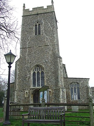
Cratfield is a village in northern Suffolk, England. "It has a population of 292 according to the 2011 census." Neighbouring villages include Laxfield, Metfield, Cookley, Huntingfield, Heveningham. The nearest town, Halesworth, is approximately 6.7 miles (10.7 km) away. Southwold is a popular, nearby coastal town. The market town of Framlingham is also close by.

<span class="mw-page-title-main">Rickinghall Inferior</span> Human settlement in England

Rickinghall Inferior is a civil parish in the Mid Suffolk district of Suffolk, England. According to the 2011 census there were 233 males and 216 females in this civil parish, for a total population of 449. It includes the western part of the village of Rickinghall and is adjacent to the village and parish of Wattisfield. The old road from the market town of Bury. St Edmunds to the City of Norwich and the town of Great Yarmouth passes through the centre of the village but the new road, the A143, uses a by-pass to the East.

<span class="mw-page-title-main">Belstead</span> Human settlement in England

Belstead is a village and civil parish in the Babergh district of the English county of Suffolk. Located on the southern edge of Ipswich, around 3 miles (5 km) south-west of Ipswich town centre. It had a population of 202 according to the 2011 census. Belstead has amenities such as a village hall, St Mary's the Virgin Church, The bridge school for children with learning difficulties and Belstead Brook Hotel and Spa. It is in the Belstead Brook electoral division of Suffolk County Council.

<span class="mw-page-title-main">Parham, Suffolk</span> Village and civil parish in Suffolk, England

Parham is a village and civil parish in the East Suffolk district of Suffolk in eastern England. Located seven miles north of Woodbridge, in 2005 it had a population of 300, reducing to 263 at the 2011 census and according to the 2011 census there were 129 males and 134 females living at this time.

<span class="mw-page-title-main">Brent Eleigh</span> Human settlement in England

Brent Eleigh is a village and civil parish in the Babergh district of Suffolk, England. Located between Hadleigh and Lavenham, in 2005 it had a population of 180 reducing to 174 at the 2011 census.

<span class="mw-page-title-main">Heveningham</span> Village in Suffolk, England

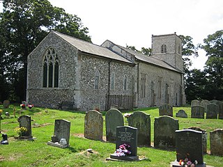
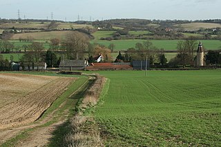
Heveningham is a village and civil parish in the East Suffolk district of Suffolk in eastern England. Located four miles south-west of Halesworth, in 2005 it had a population of 120.

<span class="mw-page-title-main">Clopton, Suffolk</span> Human settlement in England

Clopton is a village and civil parish in Suffolk. It is located between Ipswich and Debenham two kilometres north of Grundisburgh on the River Lark. The village is no larger than a series of houses either side of the B1078, surrounded by farm land. The village itself has no clear centre; houses and other buildings are concentrated around the four manors of Kingshall, Brendhall, Rousehall and Wascolies, all of which are mentioned in the Domesday Book of 1086.

<span class="mw-page-title-main">Flowton</span> Village and civil parish in Suffolk, England

Flowton is a village and civil parish in the Mid Suffolk district of Suffolk in eastern England, with a population of 117 people. The name 'Flowton' originally derives from the word 'Flocctun', meaning a flock of sheep or a sheep farm. The parish is located around six miles north west of Ipswich, which is the county town of Suffolk. Flowton contains the hamlet of Flowton Brook, and consists of rural farmland accompanied by scattered farm houses and a few newer builds situated nearby the parish church of 'St Mary's'. In the 1870s, Flowton was described as:

<span class="mw-page-title-main">Hessett</span> Human settlement in England

Hessett is a village and civil parish in the Mid Suffolk district of Suffolk in eastern England. Hessett is located around four miles south-east of Bury St Edmunds. It is a rural village with a single north-south road off which most other roads flow. In 2011 its population was 464 which is towards the highest recorded population since its peak in 1850. Hessett is south of Beyton and west of Drinkstone.

<span class="mw-page-title-main">Fakenham Magna</span> Human settlement in England

Fakenham Magna is a village and civil parish in the West Suffolk district of Suffolk in eastern England. The meaning of the word 'Fakenham' can be split into two: 'Faken' and 'ham', both of which derive from Old English. The former refers to somebody by the name of 'Facca', with the latter meaning 'a village / a homestead', making the direct translation 'Facca's homestead'. 'Magna' translates from Latin as 'great', hence the alternative name of the village of 'Great Fakenham'. During World War Two, however, the village was referred to as 'Little Fakenham', which was used to avoid confusion with the larger civil parish of Fakenham in Norfolk.

<span class="mw-page-title-main">Withersfield</span> Human settlement in England

Withersfield is a village and civil parish in the West Suffolk district of Suffolk in eastern England. In 2011 its population was 450. It has a public house and a village hall, and centres on the parish church, St. Mary the Virgin. It is in a rural location, surrounded by farmland, yet only a mile north of the busy market town of Haverhill. Surrounding villages include Great Wratting, West Wickham and Great Thurlow.

<span class="mw-page-title-main">Stansfield</span> Human settlement in England

Stansfield is a village and civil parish in the West Suffolk district of Suffolk in eastern England. Located seven miles south-west of Bury St Edmunds, in 2011 its population was 221. The village has an Anglican church dedicated to All Saints. In 1870, John Marius Wilson's Imperial Gazetteer of England and Wales described Stansfield as

<span class="mw-page-title-main">Ousden</span> Human settlement in England

Ousden is a village and civil parish in the West Suffolk district of Suffolk in eastern England. It is located around 6 miles (10 km) west of Bury St Edmunds and 72 miles (116 km) north of London, and as of 2011, its population is 266. The village has an Anglican church of St Peter's and a chapel in the cemetery dedicated to St Barnabas.

<span class="mw-page-title-main">Stanfield, Norfolk</span> Human settlement in England

Stanfield is a civil parish in the English county of Norfolk. It covers an area of 3.80 km2 (1.47 sq mi) and had a population of 162 in 2011, and 144 at the 2001 census. For the purposes of local government, it falls within the district of Breckland. Stanfield belongs to the Parliamentary Constituency of Mid-Norfolk and is currently governed by George Freeman as their member of Parliament who is representative of the Conservative Party.

<span class="mw-page-title-main">Lamarsh</span> Human settlement in England

Lamarsh is a village and a civil parish in the Braintree District, in the county of Essex, England. It is near the large village of Bures and the village of Alphamstone. The village is west of the River Stour. It has a pub, a village hall and a church called The Friends of Holy Innocents Church. The civil parish's name, Lamarsh, comes from the phrase "Loamy marsh". This is derived from the Old English terms lām and mersc, which translate into loam or clay and a marsh respectively.

<span class="mw-page-title-main">Walpole, Suffolk</span> Human settlement in England

Walpole is a small village and civil parish in the district of East Suffolk in Suffolk, England. Walpole has a parish church, a redundant chapel, but the primary school has closed. The village is on the River Blyth. Nearby settlements include the town of Halesworth and the village of Cookley. It was in the hundred of Blything. It had a population of 238 according to the 2011 census.

<span class="mw-page-title-main">Shottisham</span> Human settlement in England

Shottisham is a village and civil parish in the East Suffolk district, in the county of Suffolk. It lies in the Wilford Hundred, about four and a half miles south-east of Woodbridge, between the parishes of Sutton, Alderton, Ramsholt and Hollesley, in the Bawdsey peninsula. About three miles from the coast at Hollesley Bay and Shingle Street, the village street overlooks a slight hollow of meads and copses at the road crossing of Shottisham Creek, a tributary brook of the river Deben.

<span class="mw-page-title-main">Eyke</span> Human settlement in England

Eyke is a village and a civil parish in the East Suffolk district, in the English county of Suffolk. It is located on the A1152 road near the town of Woodbridge. Eyke has a primary school, the manor house of Lord and Lady Lucas with scenic pond and horse paddock, and a pub. The mediaeval parish church of All Saints was restored in the 1860s. Services are normally held on the first and third Sundays of the month.

<span class="mw-page-title-main">Sibton</span> Human settlement in England

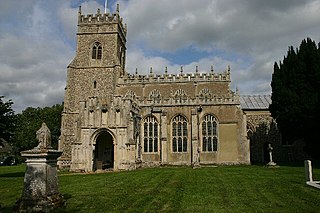
Sibton is a village and civil parish on the A1120 road, in the East Suffolk district, in the English county of Suffolk. It is near the towns of Saxmundham and Halesworth, the village of Peasenhall and the hamlet of Sibton Green. The church is dedicated to St Peter; there is also the remains of a medieval abbey, Sibton Abbey. There is a large stately house set in the grounds of Sibton Park which dates back 1827 in the Georgian period, which is now used as a hotel. The estate consists of 4500 acres, being part of the Wilderness Reserve where there are holiday cottages and a lake. The Parish is also in close proximity to the River Yox which runs past the White Horse Inn and down through Pouy Street, it then goes on past both the A1120 road and a small, wooded area called Abbey Woods to pass through the grounds of Sibton Park and then on to Yoxford.

<span class="mw-page-title-main">Huntingfield, Suffolk</span> Human settlement in England

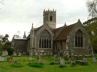
Huntingfield is a village near the B1117 road, in the East Suffolk district, in the county of Suffolk, England. The village is close to the source of the River Blyth and the parish is 12 miles from the seaside town of Southwold. Nearby settlements include the town of Halesworth and the villages of Walpole, Heveningham, Cookley and Laxfield.

References

  1. 1 2 "Worlingworth (Parish): Key Figures for 2011 Census: Key Statistics". Neighbourhood Statistics. Office for National Statistics. Retrieved 5 February 2014.
  2. "Welcome". Worlingworth CEVC Primary School. Retrieved 27 February 2014.
  3. 1 2 "Listed Buildings in Worlingworth, Suffolk, England". British Listed Buildings. Retrieved 20 March 2014.
  4. "St. Mary's Church". Worlingworth Local History Group. Retrieved 27 February 2014.
  5. "Key to English Place-names". The University of Nottingham. Retrieved 25 February 2014.
  6. Plamer, Professor J.J.N. "Place: Worlingworth". University of Hull. Retrieved 3 March 2014.
  7. Ingate, Rosemary; Robinson, Geoffrey (2016). Worlingworth past and present in photographs. Volume two. Worlingworth: Worlingworth Local History Group. ISBN   978-0-9572292-2-8.
  8. Wilson, John Marius (1870–72). Imperial Gazetteer of England and Wales (1st ed.). Edinburgh: A.Fullarton & Co. Retrieved 5 February 2014.
  9. "Places". Worlingworth Local History Group. Retrieved 19 March 2014.
  10. "The Parish Workhouse". Worlingworth Local History Group. Retrieved 27 April 2014.
  11. 1 2 3 "About our village". Welcome To Worlingworth. Retrieved 19 March 2014.
  12. "Total Population". A Vision of Britain Through Time. Retrieved 23 April 2014.
  13. "Sex, 2011". Neighbourhood Statistics. Retrieved 23 April 2014.
  14. "Social Status, based on 1831 occupational statistics". A Vision of Britain. Retrieved 27 April 2014.
  15. "Enumeration abstract, 1831 (Part 2) page 614". Online Historical Population Reports. University of Essex. Retrieved 27 March 2014.
  16. "1881 Census of England and Wales". A Vision of Britain Through Time. Retrieved 19 March 2014.
  17. "Economic Activity – All People, 2001". Neighbourhood Statistics. Retrieved 27 April 2014.
  18. "Industry, 2011". Neighbourhood Statistics. Retrieved 27 April 2014.

Commons-logo.svg Media related to Worlingworth at Wikimedia Commons