Gansu is a landlocked province in Northwest China. Its capital and largest city is Lanzhou, in the southeast part of the province.

Qinghai is a landlocked province in the northwest of the People's Republic of China. It is the largest province of China by area and has the third smallest population. Its capital and largest city is Xining.

Lanzhou is the capital and largest city of Gansu province in northwestern China. Located on the banks of the Yellow River, it is a key regional transportation hub, connecting areas further west by rail to the eastern half of the country. Historically, it has been a major link on the Northern Silk Road and it stands to become a major hub on the New Eurasian Land Bridge. The city is also a center for heavy industry and petrochemical industry.

Amdo is one of the three traditional Tibetan regions, the others being U-Tsang in the west and Kham in the east. Ngari in the north-west was incorporated into Ü-Tsang. Amdo is also the birthplace of the 14th Dalai Lama. Amdo encompasses a large area from the Machu to the Drichu (Yangtze). Amdo is mostly coterminous with China's present-day Qinghai province, but also includes small portions of Sichuan and Gansu provinces.

The Qinghai–Tibet railway or Qingzang railway, is a high-elevation railway line in China between Xining, Qinghai Province, and Lhasa, Tibet. With over 960 km (600 mi) of track being more than 4,000 m (13,123 ft) above sea level, it is the highest railway line in the world.

The Hexi Corridor (Chinese: 河西走廊; pinyin: Héxī Zǒuláng; Wade–Giles: Ho2-hsi1 Tsou3-lang2, Xiao'erjing: حْسِ ظِوْلاْ, Mandarin pronunciation:[xɤ˧˥ɕi˥tsoʊ˨˩˦lɑŋ˧˥]), also known as the Gansu Corridor, is an important historical region located in the modern western Gansu province of China. It refers to a narrow stretch of traversable and relatively arable plain west of the Yellow River's Ordos Loop (hence the name Hexi, meaning "west of the river"), flanked between the much more elevated and inhospitable terrains of the Mongolian and Tibetan Plateaus.

Jiuquan, formerly known as Suzhou, is a prefecture-level city in the northwesternmost part of Gansu Province in the People's Republic of China. It is more than 600 km (370 mi) wide from east to west, occupying 191,342 km2 (73,878 sq mi), although its built-up area is mostly located in its Suzhou District.

Golmud, also known by various other romanizations, is a county-level city in the Haixi Mongol and Tibetan Autonomous Prefecture of Qinghai Province, China. It is now the second-largest city in Qinghai and the third largest in the Tibetan Plateau. The population in 2020 is 221,863.
The Lanzhou–Qinghai railway, abbreviated as the Lanqing railway was built as the first step of an ambitious plan set by the People's Republic of China to connect Tibet with the rest of China by railway. LanQing railway, designed in 1956 and built from May 1958 to September 1959, runs 188 Kilometers long, connecting Lanzhou, the capital city of Gansu province, and Xining, the capital city of Qinghai province.

The Lanzhou−Xinjiang railway or Lanxin railway, is the longest railway in Northwestern China. It runs 1904 kilometres from Lanzhou, Gansu, through the Hexi Corridor, to Ürümqi, in Xinjiang. It was Xinjiang's only rail link with the rest of China until the opening of the Lanzhou–Xinjiang high-speed railway in December 2014. The railway follows the path of the ancient Silk Road.

Haixi Mongolian and Tibetan Autonomous Prefecture, locally also known as Qaidam Prefecture, is an autonomous prefecture occupying much of the northern half of Qinghai Province, China. It has an area of 325,785 square kilometres (125,786 sq mi) and its seat is Delingha. The name of the prefecture literally means "west of (Qinghai) Lake."

Hainan Tibetan Autonomous Prefecture, formerly known as Tsolho Tibetan Autonomous Prefecture, is an autonomous prefecture of Northeastern Qinghai Province in Western China. The prefecture has an area of 45,895 square kilometres (17,720 sq mi) and its seat is located in Gonghe County. Its name literally means "south of (Qinghai) Lake."

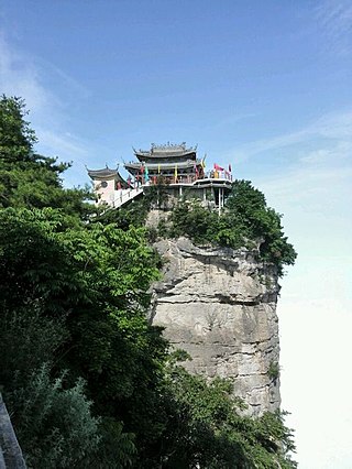
Bairi Tibetan Autonomous County, also known as Tianzhu from its Chinese name, is in the prefecture-level city of Wuwei in the central part of Gansu province, China, bordering Qinghai province to the south and west. It has an area of 7,147 km2 (2,759 sq mi) and approximately 230,000 inhabitants (2003). Its administrative seat is Rabgyai Town (Huazangsi).

The Qaidam, Tsaidam, or Chaidamu Basin is a hyperarid basin that occupies a large part of Haixi Prefecture in Qinghai Province, China. The basin covers an area of approximately 120,000 km2 (46,000 sq mi), one-fourth of which is covered by saline lakes and playas. Around one third of the basin, about 35,000 km2 (14,000 sq mi), is desert.
Longnan is a prefecture-level city in the southeast of Gansu province in China. It borders Sichuan on its south and Shaanxi on its east. As of the 2020 Chinese census, the population of the prefecture-level city was 2,855,555.
Zhangye, formerly romanized as Changyeh or known as Kanchow, is a prefecture-level city in central Gansu Province in the People's Republic of China. It borders Inner Mongolia on the north and Qinghai on the south. Its central district is Ganzhou, formerly a city of the Western Xia and one of the most important outposts of western China.

Wuwei is a prefecture-level city in northwest central Gansu province. In the north it borders Inner Mongolia, in the southwest, Qinghai. Its central location between three western capitals, Lanzhou, Xining, and Yinchuan makes it an important business and transportation hub for the area. Because of its position along the Hexi Corridor, historically the only route from central China to western China and the rest of Central Asia, many major railroads and national highways pass through Wuwei.
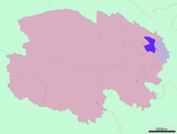
Haidong is a prefecture-level city of Qinghai province in Western China. Its name literally means "east of the (Qinghai) Lake." On 8 February 2013 Haidong was upgraded from a prefecture (海东地区) into a prefecture-level city. Haidong is the third most populous administrative division in Qinghai after Xining and Golmud.

Ma Bufang (1903 – 31 July 1975) (traditional Chinese: 馬步芳; simplified Chinese: 马步芳; pinyin: Mǎ Bùfāng; Wade–Giles: Ma3 Pu4-fang1, Xiao'erjing: مَا بُفَانْ) was a prominent Muslim Ma clique warlord in China during the Republic of China era, ruling the province of Qinghai. His rank was Lieutenant-general.
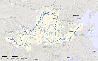
The Huangshui River or Huang Shui is a river in Qinghai and Gansu, China. The river is a left tributary of the Yellow River and its total length is 374 km (232 mi) with a basin area of 3,200 km2 (1,200 sq mi).